|
MIAMI — As the of peak the hurricane season approaches, forecasters predicted with confidence on Thursday that storm activity would remain low this year. “We have an even higher confidence that this year’s hurricane season will be below normal,” said Gerry Bell, the lead seasonal hurricane forecaster at the National Oceanic and Atmospheric Administration’s Climate Prediction… Continue reading Hurricane season is predicted to remain below average |
A Real Climate Scientist Demolishes Bill Nye’s Global Warming Alarmism
|
By Michael Bastasch Global warming alarmist talking heads like Bill Nye, Neil deGrasse Tyson and Al Gore are constantly paraded around as experts on climate, often claiming that global warming is making weather more extreme and bashing those who “deny” that humans are the main culprit behind this. So, Fox Business host John Stossel brought in… Continue reading A Real Climate Scientist Demolishes Bill Nye’s Global Warming Alarmism |
August 2 to August 8: This week in Denver weather history

On first glance our look at this week in Denver weather history appears to be less eventful than many we have looked at previously. However, the severity of the events that appear on the historical weather calendar this week are enough to make you stand up and pay attention. While August is typically a pretty quiet weather month, it is clear that severe weather can certainly strike and Thornton is mentioned in more than one significant event.
From the National Weather Service:
2
In 1878…the high temperature reached 100 degrees in downtown Denver.
In 1911…an apparent dry microburst produced sustained west winds to 42 mph.
In 1972…one workman was killed and another injured when a strong gust of wind destroyed a partially completed apartment building in south Denver. Hail to 1 3/4 inch diameter fell in Golden.
In 1973…hail to 3/4 inch diameter was reported in Boulder.
In 1986…a major outbreak of severe thunderstorms occurred along the Front Range. Thunderstorms developed explosively. Some places were hit by large hail twice. Two inch diameter hail broke car windows on I-25 west of Brighton…and up to 1 1/4 inch hail broke windows in Thornton. Baseball size hail damaged several planes near Watkins. Funnel clouds were sighted around Aurora. Hail over 1/2 inch in diameter covered the ground 3 to 4 inches deep at Hudson northeast of Denver. Most of the hail fell north of metro Denver…but 3/4 inch diameter hail was measured at Stapleton International Airport. Total damage from the hail storms this day was estimated at over 10 million dollars.
In 1991…late afternoon thunderstorms produced heavy rain across metro Denver. Two feet of water covered parts of I-25 in southeast Denver…while one foot of water covered parts of U.S. Highway 285 in Englewood. Thunderstorm rainfall totaled 0.50 inch at Stapleton International Airport.
In 2001…severe thunderstorms producing heavy rain and hail… Either washed out or damaged several County roads in the Watkins and Bennett areas. A small tornado (f0) touched down near Bennett…but did no damage. Hail as large as 1 3/4 inches in diameter fell near Watkins. One inch diameter hail was measured near Hudson and Keenesburg.
In 2008…strong winds blew several trees down in Denver… Damaging homes and downing power lines. A peak wind gust of 67 mph occurred at Centennial Airport…with gusts to 60 mph estimated in Denver. A peak wind gust of 37 mph was measured at Denver International Airport. An elderly man was killed when a wind damaged tree broke free and crushed him while he attempted to remove it. The downed power lines caused outages to about 500 Xcel energy customers.
2-3
In 1876…grasshoppers were in great abundance in the city and caused considerable damage to gardens and to crops in the surrounding farms and ranches.
In 1951…heavy thunderstorms rumbled across metro Denver through the night. Heavy rain totaled 3.45 inches at Stapleton Airport. This was the greatest 24 hour precipitation ever recorded during the month of august in Denver.
In 2007…heavy rain caused localized flash flooding near Ft. Lupton. Up to 8 inches of water was reported across County road 18. In addition…several other County roads in the immediate area were washed out.
3
In 1878…the high temperature climbed to 100 degrees in downtown Denver.
In 1900…a thunderstorm produced west winds sustained to 48 mph with gusts to 55 mph…but only a trace of rain.
In 1903…a thunderstorm produced a trace of rainfall and northwest winds sustained to 45 mph with gusts to 60 mph. The high temperature was 99 degrees.
In 1927…a thunderstorm produced hail and sustained north winds to 22 mph.
In 1933…heavy cloudburst rains caused the failure of the Castlewood dam…which resulted in flash flooding on Cherry Creek…the deaths of 7 people in Denver…and flood damage estimated at 1 million dollars. Lower Denver was flooded during the morning by waters pouring down Cherry Creek and its valley from Castlewood Dam…which had broken between midnight and 2:00 am. Heavy rain of 3 to 9 inches in 9 hours in the watershed above the dam resulted in the failure. At 7:30 am…the flow in Cherry Creek was reported at 16 thousand second-feet as compared with a peak flow of 3 thousand second-feet in other years. The flood waters ruined hundreds of acres of crops and drowned scores of farm animals. Six bridges in Denver were swept away. Great deposits of mud were left in the lower sections of the city…including hundreds of basements and lower floors of buildings. At the end of the month…a deadly stench still rose from swampy areas near the lower city limits.
In 1963…heavy thunderstorm rains in the Parker area caused Cherry Creek to overflow…which damaged roads.
In 1985…a tornado touched down briefly about 10 miles northeast of Parker. No damage was reported.
In 1991…upslope northeast winds produced chilly temperature readings and heavy rain across metro Denver. Rainfall… With no thunder…totaled 1.56 inches at Stapleton International Airport where the heavy rain briefly reduced the surface visibility to 7/8 mile. The mercury climbed to a high of only 63 degrees.
In 1992…a thunderstorm wind gust to 64 mph was recorded in Brighton. A wind gust to 60 mph was measured near the construction site of the new Denver International Airport. Lightning started a fire in an Evergreen church…causing over 75 thousand dollars in damage.
In 1998…3/4 inch hail fell in Jefferson County 15 miles northwest of Arvada.
In 2006…heavy thunderstorm rainfall caused flash flooding along Leyden Creek in unincorporated Jefferson County. An automated rain gauge on upper Leyden Creek…6 miles northwest of Arvada…measured 2.68 inches of rainfall in less than 2 hours. Two to three feet of water covered the roadway at the intersection of 82nd and Quaker Street.
In 2009…a woman riding her bike… In training for an ironman triathlon…was struck by lightning in Boulder. She was in the 78th mile of a 100-mile training ride when she was hit. The woman lost her vision initially and couldn`t move her arms. After a short stay in the hospital…she made of complete recovery.
In 2013…severe wet microburst thunderstorms produced damaging winds and very heavy rain in and around Buckley Air Force Base…Erie and Lafayette. Peak gusts included: 68 mph in Erie…61 mph at Buckley AFB… And 60 mph in Broomfield…4 miles east-southeast of Erie and Lafayette. In Erie…a velodrome under construction was heavily damaged by heavy rain and high winds. The wind toppled the eastern third of the 250-meter cycling track. Bolts measuring one-half-inch thick by 7 1/2 inches in length were ripped out of concrete footers while 16-inch-wide trusses…collapsed under the force of the wind. In town…heavy rain… Around 2.5 inches in less than one hour…caused extensive street flooding. The intense wind also downed trees which resulted in localized power outages. In addition…an empty semi-trailer was blown on its side. A weak non supercell tornado touched down briefly in an open field…7 miles northwest of Hudson. The storm forced seven incoming flights at Denver International Airport to be diverted and contributed to 45-minute delays for others. At Denver International Airport…a peak wind gust of 55 mph was observed from the northeast…with 0.66 inches of rainfall recorded. The very heavy rain produced flash flooding in part of Aurora. Road closures were set up in both directions on both Picadilly Road and Gun Club Road…just north of Buckley AFB. A man had to be rescued when his car was trapped in flood waters at the intersection of 6th Ave. and Picadilly Road. Flash flooding was also observed at the junction of e-470 and I-70 with water running over the road.
3-4
In 1988…two inches of rain fell in 3 hours at both Morrison and Wheat Ridge. Thunderstorm rainfall totaled 0.80 inch overnight at Stapleton International Airport.
4
In 1889…southwest winds were sustained to 42 mph with an extreme velocity to 52 mph.
In 1924…0.01 inch of rain fell over downtown Denver. This along with the 0.01 inch of rainfall on the 10th was the only rainfall of the month…the driest august on record.
In 1963…heavy rains in the foothills above Idaho Springs caused mud and rock slides which closed U.S. Highways 6 and 40 for a time.
In 1976…hail to 1 inch diameter was reported 12 miles southwest of Denver. Hail to 3/4 inch in diameter was reported in Lakewood. Small hail…1/4 to 1/2 inch in diameter…fell at Stapleton International Airport.
In 1982…heavy rain poured through the roof of a clothing store in Aurora…causing widespread water damage. The roof was being repaired when the storm hit.
In 1983…hail up to one inch in diameter fell in Aurora where heavy rain produced street flooding.
In 1984…a Colorado state trooper was struck and injured by lightning in Northglenn.
In 1989…a microburst wind gust to 52 mph was recorded at Stapleton International Airport.
In 1997…lightning sparked a small fire in a home in Arvada… Causing minor damage. Several intersections in both Arvada and Westminster were flooded by thunderstorms producing heavy rain. Several cars were damaged by the high waters… And a number of businesses were flooded.
In 1999…flooding and flash flooding problems developed over metro Denver as slow moving thunderstorms dumped from 2 to 3.5 inches of rainfall in about 3 hours. Near the junction of I-25 and U.S. Highway 36…up to 4 feet of water flooded an auto dealership. About 45 cars were ruined. Damage estimates to the dealership alone totaled nearly a half million dollars. Sections of I-25 and U.S. 36 near the interchange were closed due to floodwaters. Floodwaters… Up to 5 feet deep…forced the evacuation of two mobile home parks in Federal Heights. Railroad tracks were washed out near Federal Blvd. and 64th Avenue. Numerous power outages caused widespread blackouts in Thornton and Littleton. Along Massey Draw near Carr St. and Chatfield Reservoir…4 homes were flood damaged and portions of their backyards washed out. Widespread street flooding was also reported in Boulder where several buildings were flood damaged…including the University of Colorado Memorial Center.
In 2004…two golfers were shocked when lightning struck the eighth green of the golf course at Castle Pines North of Castle Rock. The two men suffered only minor injuries. Heavy thunderstorm rain from the same storm caused flash flooding. Floodwaters rushed across parts of U.S. Highway 85 near the entrance to the castle pines golf club. The traffic lanes were covered with up to 6 inches of running water.
In 2008…lightning sparked a grassfire that consumed 300 acres on the northern edge of Green Mountain…in Jefferson County. Gusty winds and very dry conditions allowed the wildfire to quickly spread and threaten several houses. Fortunately…only minor damage was reported to homes due to smoke and melted siding.
Continue reading August 2 to August 8: This week in Denver weather history
Obama power plant rules spark 2016 fight over climate change
|
WASHINGTON (AP) – President Barack Obama’s sweeping new power plant regulations are thrusting the divisive debate over climate change into the race for the White House, with candidates in both parties seeing an opportunity to capitalize. To Democrats, rallying around global climate change is a way to energize liberal supporters and paint Republicans as out of… Continue reading Obama power plant rules spark 2016 fight over climate change |
Update: Typhoon Soudelor continues to intensify
|
The typhoon with international name “Soudelor” (International Name) continues to gain strength and expected to enter the Philippine Area of Responsbility (PAR) by Wednesday morning, the Philippine Atmospheric Geophysical and Astronomical Services Administration (PAGASA) said in its weather bulletin issued at 11 a.m. on Tuesday. PAGASA said that as of 10 a.m. The Typhoon “Soudelor” was… Continue reading Update: Typhoon Soudelor continues to intensify |
Over 100 dead in India floods
|
New Delhi (dpa) – More than 100 people have been killed, most of them in India’s eastern states, during heavy rains and floods over the past week, officials said Monday. More than 4 million people in 10,000 villages were affected in the states of West Bengal, Orissa and Manipur after cyclone Komen struck the region on… Continue reading Over 100 dead in India floods |
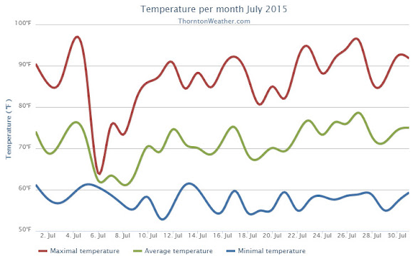
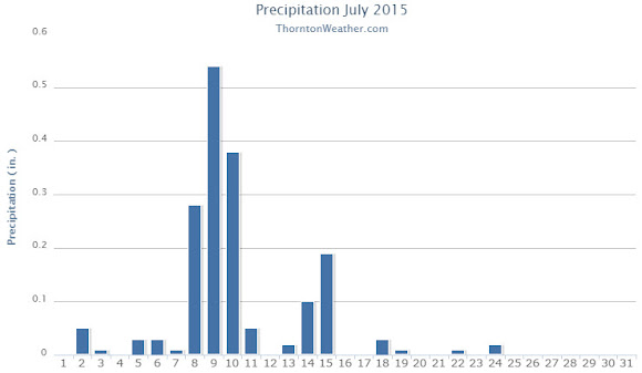
July 2015 weather recap: Cooler than normal temps, a bit drier than average
The month of July continued the recent trend of cool, damp weather. By the time it was said and done though, while temperatures overall were below average, precipitation fell short of normal.
Temperatures were at or above normal for the first few days allowing for a pleasant Independence Day.
The day after, however, a monsoonal weather pattern cooled things down and brought most of the month’s moisture over the following 10 days.
Ridging then built and we settled into a relatively normal period for the final two weeks although precipitation became scarcer.
Thornton saw an average temperature for July 2015 of 71.2 degrees. This was a good bit below the long term Denver average of 74.2 degrees. Out at Denver International Airport where the Mile High City’s official measurements are taken, the average for the month was 72.8 degrees.
Our temperatures ranged from a high of 96.1 degrees on the 27th down to a low of 53 degrees on the 11th. Denver saw a maximum of 97 degrees and a minimum of 52 degrees.
Denver averages 2.16 inches of precipitation during July. Thornton fell a bit short of that mark recording 1.76 inches. At the airport, only 1.06 inches was recorded.
Click here to view Thornton’s July 2015 climate report.
CLIMATE REPORT
NATIONAL WEATHER SERVICE BOULDER, CO
202 PM MDT SAT AUG 1 2015

...................................

...THE DENVER CO CLIMATE SUMMARY FOR THE MONTH OF JULY 2015...

CLIMATE NORMAL PERIOD 1981 TO 2010
CLIMATE RECORD PERIOD 1872 TO 2015

WEATHER         OBSERVED          NORMAL  DEPART  LAST YEAR`S
                 VALUE   DATE(S)  VALUE   FROM    VALUE  DATE(S)
                                          NORMAL
................................................................
TEMPERATURE (F)
RECORD
 HIGH             105   07/20/2005
 LOW               42   07/04/1903
                        07/31/1873
HIGHEST            97   07/27                        100  07/07
LOWEST             52   07/28                         55  07/17
                                                          07/16
AVG. MAXIMUM     87.6              89.4    -1.8     88.3
AVG. MINIMUM     57.9              58.9    -1.0     60.6
MEAN             72.8              74.2    -1.4     74.5
DAYS MAX >= 90     16              16.0     0.0       17
DAYS MAX <= 32      0               0.0     0.0        0
DAYS MIN <= 32      0               0.0     0.0        0
DAYS MIN <= 0       0               0.0     0.0        0
PRECIPITATION (INCHES) RECORD
MAXIMUM         6.41   1965
MINIMUM         0.01   1901
TOTALS           1.06              2.16   -1.10     3.85
DAILY AVG.       0.03              0.07   -0.04     0.12
DAYS >= .01        12               8.3     3.7        8
DAYS >= .10         3               4.3    -1.3        6
DAYS >= .50         0               1.4    -1.4        2
DAYS >= 1.00        0               0.7    -0.7        2
GREATEST
 24 HR. TOTAL    0.33   07/18/15                    2.85  07/29/14
                        07/18/15                          07/30/14

SNOWFALL (INCHES)
 TOTAL            0.0                                0.0

DEGREE_DAYS
HEATING TOTAL       5                 6      -1        5
 SINCE 7/1          5                 6      -1        5
COOLING TOTAL     251               289     -38      304
 SINCE 1/1        409               444     -35      431

FREEZE DATES
RECORD
 EARLIEST     09/08/1962
 LATEST       06/08/2007
EARLIEST                        10/07
LATEST                          05/05
..................................................

WIND (MPH)
AVERAGE WIND SPEED              9.3
RESULTANT WIND SPEED/DIRECTION   3/176
HIGHEST WIND SPEED/DIRECTION    46/320    DATE  07/15
HIGHEST GUST SPEED/DIRECTION    60/330    DATE  07/15

SKY COVER
POSSIBLE SUNSHINE (PERCENT)   MM
AVERAGE SKY COVER           0.60
NUMBER OF DAYS FAIR            4
NUMBER OF DAYS PC             22
NUMBER OF DAYS CLOUDY          5

AVERAGE RH (PERCENT)     52

WEATHER CONDITIONS. NUMBER OF DAYS WITH
THUNDERSTORM              0     MIXED PRECIP               0
HEAVY RAIN                3     RAIN                       1
LIGHT RAIN               16     FREEZING RAIN              0
LT FREEZING RAIN          0     HAIL                       0
HEAVY SNOW                0     SNOW                       0
LIGHT SNOW                0     SLEET                      0
FOG                       7     FOG W/VIS <= 1/4 MILE      0
HAZE                      6

-  INDICATES NEGATIVE NUMBERS.
R  INDICATES RECORD WAS SET OR TIED.
MM INDICATES DATA IS MISSING.
T  INDICATES TRACE AMOUNT.
Thornton’s August weather preview: Cooler weather arrives
As summer vacations wind down and families prepare to send their kids back to school in August, Colorado weather also starts to settle down. The chances for severe weather decrease markedly during August and by the end of the month daytime temperatures are dropping quite a bit as well.
Find out more about what lies ahead with Thornton’s August weather here.

July 2015 top shots: Monthly photo slideshow
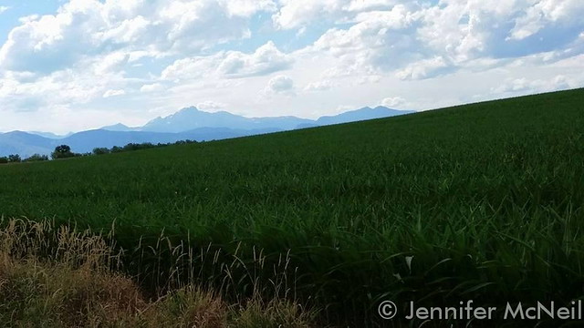
Colorado offers outdoor opportunities unlike any other state and while the summer heat settles in, photos of the amazing scenes across our state provide a view into why we love it here so much.
The weather this time of year has a pretty standard pattern of quickly warming temperatures followed by afternoon thunderstorms that can cool things down. These storms sometimes provide a good bit of ‘excitement’ and are a prime photo subject.
- Slideshow updated July 31, 2015
Recreationalists head outdoors and take advantage of urban, suburban and rural opportunities. As they do, our abundant wildlife that is found just about anywhere comes into focus.
Showcasing images captured by ThorntonWeather.com readers as well as some of our own, our monthly slideshow covers the entire gamut of weather and nature related imagery. Sunsets, sunrises, wildlife and of course every type of weather condition are vividly depicted.
To learn more about how to send your photo to us for inclusion in the slideshow, see below the slideshow.
| [flickr_set id=”72157656079164135″] |
What is missing in the slideshow above? Your photo!
Our monthly photo slideshow is going to feature images that we have taken but more importantly images that you have captured. The photos can be of anything even remotely weather-related.
Landscapes, current conditions, wildlife, pets, kids. Whimsical, newsy, artsy. Taken at the zoo, some other area attraction, a local park, a national park or your backyard. You name it, we want to see and share it!
Images can be taken in Thornton, Denver or anywhere across the extraordinary Centennial State. We’ll even take some from out of state if we can tie it to Colorado somehow.
We’ll keep the criteria very open to interpretation with just about any image eligible to be shown in our slideshows.
What do you win for having your image in our slideshow? We are just a ‘mom and pop’ outfit and make no money from our site so we really don’t have the means to provide prizes. However you will have our undying gratitude and the satisfaction that your images are shared on the most popular website in Thornton.
To share you images with us and get them included in the slideshow just email them to us or share them with ThorntonWeather.com on any of the various social media outlets. Links are provided below.
So come on, get those camera’s rolling!
- Email: info@ThorntonWeather.com
- Facebook: https://www.facebook.com/ThorntonWeather
- Google+: https://plus.google.com/+Thorntonweather
- Twitter: @ThorntonWeather (https://twitter.com/thorntonweather)
Climate change ‘urgent and growing threat’ to national security: Pentagon
|
A new Pentagon report says that climate change is an “urgent and growing threat to our national security” and blames it for “increased natural disasters” that will require more American troops designated to combat bad weather. Some studies have questioned whether such a trend exists. Says the Pentagon report released Wednesday, “Global climate change will have… Continue reading Climate change ‘urgent and growing threat’ to national security: Pentagon |