On June 3, 1981 a tornado struck Thornton in what is the worst twister to have struck the Denver metro area. Are you ready should disaster strike again? Image courtesy the City of Thornton archives.
Severe weather is a fact of life in Colorado – from blizzards to tornadoes we can and do see it all. Each year the weather is responsible for claiming lives in our state and across the nation and the threat is very real. Storm spotter training allows you to learn how to protect yourself and your family while providing a public service.
Education is key to knowing how to protect you and your family. Whether you want to be an official storm spotter or maybe just want to learn more about severe weather, storm spotter training can provide you an incredible opportunity to learn.
The storm spotter program is a nationwide program with more than 280,000 trained spotters. These volunteers report weather hazards to their local National Weather Service office providing vital information when severe strikes. Data from spotters include severe wind, rain, snow measurements, thunderstorms and hail and of course tornadoes.
Storm spotters are part of the ranks of citizens who form the Nation’s first line of defense against severe weather. There can be no finer reward than to know that their efforts have given communities the precious gift of time–seconds and minutes that can help save lives.
By completing one of these training classes you can become an official storm spotter. When severe weather strikes, you can report it by calling a special toll free number or submit your report via the National Weather Service’s website.
These are great sessions for anyone wanting to learn more about the severe weather we experience in Colorado, whether you want to be an official spotter or not. All training is free. Topics include:
Below are the dates, times and locations announced thus far. The embedded calendar should automatically update with new dates and changes but be sure to check the National Weather Service site for the latest.
March 6 to March 12: This Week in Denver Weather History
March is Denver’s snowiest month and it is not unusual for us to receive heavy, wet snows during this time. Our look back at this week in Denver weather history highlights many such events.
From the National Weather Service:
4-6
In 1931…a cold front with north winds gusting to 35 mph on the evening of the 4th brought snowfall on the 5th into the early morning of the 6th. Heavy snowfall totaled 6.2 inches. Temperatures plunged from a high of 58 degrees on the 4th to a low of only 22 degrees by midnight…which was also the high reading on the 5th.
In 1983…a slow moving moisture laden storm produced heavy snow and rain. Two to three feet of snow fell in the foothills at Wondervu and Nederland. The southern portion of metro Denver was buried with 26 inches of snow in southeast Aurora…25 inches at Franktown…and 19 inches at Littleton. Snowfall totaled 18.7 inches at Stapleton International Airport with most of the snow…18.0 inches… Falling on the 5th. Brighton received only 11 inches of new snow. Boulder was drenched by rain and received no snow. Precipitation from the storm totaled 3.06 inches at Stapleton International Airport where north winds gusted to 28 mph. The heavy wet snow snapped many tree limbs…which fell on power and phone lines causing many outages. Numerous highways were closed. Two thousand travelers were stranded at Stapleton International Airport where only one runway was open for a time. Many flights were canceled. One home in Denver was severely damaged when its roof collapsed under the weight of the heavy snow. The 2.68 inches of precipitation on the 5th was the greatest calendar day precipitation ever recorded in the city during March. The 2.79 inches of precipitation on the 4th and 5th was the greatest 24 hour precipitation ever measured during March.
5-6
In 1935…3.0 inches of snow fell in downtown Denver. This was the only measurable snow of the month. Northwest winds gusted to 29 mph on the 5th.
In 1940…heavy snowfall totaled 9.1 inches over downtown Denver. North winds gusted to 22 mph.
In 2000…high winds developed in and near the foothills just prior to the passage of an upper level storm system moving in from the west. Peak gusts from the windstorm included: 88 mph at the National Center for Atmospheric Research near Boulder…82 mph in Boulder…80 mph at the national wind technology center south of Boulder…79 mph on Rocky Flats…and 71 mph in Golden Gate Canyon. Several power lines were downed causing a few brief outages. Thunderstorms produced southeast wind gusts to 51 mph at Denver International Airport on the 5th.
In 2003…high winds spread from the mountains down the eastern slopes. The highest wind gusts were 85 mph atop the Gamow Tower on the University of Colorado campus in Boulder and 70 mph at the national wind technology center on Rocky Flats west of Broomfield. West winds gusted to 44 mph at Denver International Airport on the 6th.
6
In 1900…west winds were sustained to 41 mph with gusts to 49 mph.
In 1920…the high temperature warmed to only 6 degrees… The all-time record low maximum temperature for the month of March. The same reading also occurred on March 10…1948.
In 1972…a wind gust to 100 mph was recorded at Jefferson County Airport in Broomfield. Winds gusted in Boulder at speeds of 50 to 65 mph. A light plane was overturned… And there was damage to other planes at Boulder airport. The roof of a garage was blown off…and a mobile home was overturned in Boulder. A truck was blown off the highway 15 miles east of Boulder. West winds gusted to 51 mph at Stapleton International Airport. The warm Chinook winds were responsible for setting a new record high temperature for the date of 75 degrees…exceeding the old record of 72 degrees set in 1925.
In 1990…a blizzard pummeled metro Denver. Snow fell at a rate of 2 to 3 inches an hour. Gusty north winds whipped the snow into 2- to 3-foot drifts by noon. During the afternoon many stores and schools closed. By rush hour sustained winds of 35 to 46 mph and gusts to 58 mph reduced visibilities to near zero and whipped the new snow into 3- to 4-foot drifts. Many residential as well as secondary and primary roads became impassable. I-25 and I-70 were closed in and out of the city. Road crews cleared drifts as high as 12 feet in southeast Boulder and northwest Adams counties. Several hundred rush hour commuters…including the state’s governor…were caught in the blizzard conditions along a 15-mile stretch of the Denver-Boulder turnpike. Many remained snowbound in their vehicles up to 8 hours until rescued by police and the National Guard. The highway remained closed until mid-day on the 7th. Shelters for stranded commuters and travelers were opened in Broomfield and Castle Rock. Many workers didn’t even try to go home…but filled downtown hotels to near capacity. By early evening…Stapleton International Airport was shut down after an airliner with 82 passengers aboard skidded off a runway. Snowfall totals for the storm varied from 18 to 50 inches in the foothills above 6 thousand feet…9 to 24 inches west of I-25…and 2 to 12 inches over eastern metro Denver. Snowfall from the storm totaled 11.8 inches at Stapleton International Airport where the maximum snow depth on the ground was 7 inches due to melting.
In 2004…very strong downslope winds developed in and near the eastern foothills…causing numerous traffic accidents and extensive property damage to roofs and aluminum sheds. Three semi-trucks were toppled by the strong winds near the I-70 and C-470 interchange. One of the trucks was carrying a modular home…while another was hauling hazardous material. I-70 had to be closed in both directions until the accidents could be cleaned up. Strong winds forced the closure of State Highway 93 between Golden and Boulder…when the road became icy and snowpacked from localized ground blizzards. Another semi- truck was blown over near the intersection of State Highways 72 and 93 atop Rocky Flats. Scattered power outages were reported across northern and western sections of metro Denver…affecting around 2000 residents. In Boulder…several pine trees were uprooted by the high winds.
6-7
In 1981…a storm dumped 4 to 8 inches of snow over higher elevations between Denver and Colorado springs. At Stapleton International Airport…north winds gusted to 16 mph and snowfall totaled only 2.5 inches.
In 1998…heavy snow fell over portions of metro Denver and the adjacent foothills. Snowfall totals included 11 inches at Chief Hosa…10 inches near Evergreen…8.5 inches in Broomfield…8 inches at Bailey…and 7 inches at both Standley Lake and Thornton. Elsewhere…snowfall across metro Denver ranged from 3 to 6 inches with 4.9 inches measured at the site of the former Stapleton International Airport. North winds gusted to 26 mph at Denver International Airport on the 7th. Several accidents occurred along area roads and highways when they became icy and snowpacked.
6-8
In 1932…snowfall totaled 6.3 inches in downtown Denver. Most of the snow…5.2 inches…fell on the 8th. Northeast winds gusted to 20 mph on the 6th.
7
In 1872…heavy rain started shortly after midnight and soon turned to sleet…which continued to just after sunrise…the ground at that time not even being white. At about 7:00 am the worst snow storm of the winter commenced and continued until 10:00 pm…snowing heavily nearly all the time. North winds averaged a sustained speed of 25 mph. About 8 inches of snow fell…but it drifted too much to obtain a direct measurement.
In 1901…northwest winds were sustained to 40 mph with gusts as high as 58 mph. The strong Chinook winds warmed the temperature to a high of 70 degrees.
In 1902…northwest winds were sustained to 45 mph with gusts to 53 mph.
In 1950…strong north winds at 40 mph with gusts as high as 60 mph produced a dust storm across metro Denver. At Stapleton Airport…blowing dust reduced visibility to as low as 1/4 mile for most of the day.
In 1972…northwest winds gusted to 51 mph at Stapleton International Airport. The Chinook winds warmed temperatures to a high of 64 degrees.
In 1984…a wind gust to 63 mph was recorded at Golden Gate Canyon west of Denver. West winds gusted to 39 mph at Stapleton International Airport.
7-8
In 1878…snow from the evening of the 7th until noon of the 8th totaled only 5 inches in downtown Denver. Apparent heavier snow over the plains along with strong winds drifted the snow into high drifts…which delayed trains for several days and caused a great loss of livestock. Melting of the snow caused a rise in Cherry Creek…which resulted in much damage. Precipitation from the storm totaled only 0.50 inch in Denver.
In 2000…high winds developed in and near the Front Range foothills…as well as parts of the northeast Colorado plains as another pacific storm system moved across the area. Several trees and power lines were downed near Blackhawk…Boulder…and in Coal Creek Canyon. About 30 homes in the Pinebrook Hills subdivision in Boulder were evacuated when downed power lines sparked a grassfire. The winds eventually shifted the fire onto itself…thus allowing firefighters to contain the two acre blaze. Several roofs were blown off barns…sheds… And garages. Two semi-trailers were blown over…one along C-470 between Golden and Morrison and another north of Denver on I-25. Wind gusts reached 101 mph on Rocky Flats…100 mph at the nearby national wind technology center…90 mph at Blackhawk and atop Blue Mountain…92 mph in south Boulder…73 mph in Coal Creek Canyon…72 mph in Golden…and 70 mph at Louisville. Northwest winds gusted to 45 mph on the 7th and to 49 mph on the 8th at Denver International Airport.
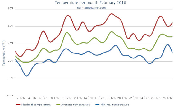
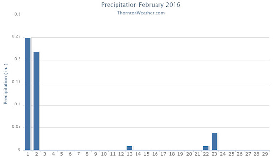
The month of February was a bit of a mixed bag of weather conditions for Thornton. While it started out cold and snowy, it finished quite warm.
Snow and cold were the main features for the month initially as we received our biggest snowfall of the season on the 1st and 2nd. Thornton recorded a healthy 11.1 inches from the system while Denver officially saw 11.6 inches.
The white stuff and the cold with it did not last long however. Cold did linger for a few days but an extended period from the 9th to the 20th saw dry conditions and warmer than normal temperatures.
A very brief interlude then arrived cooling things down and delivering light snow on the 23rd. From there, the warm and dry conditions returned and closed out the month.
Thornton saw an average monthly temperature of 38.5 degrees for the month. Out at the airport where Denver’s official measurements are taken, the month averaged 37.8 degrees. Both were well above the historical February average of 32.5 degrees.
Temperatures in Thornton ranged from a high of 74.5 degrees on the 18th down to a low of 3.3 degrees on the morning of the 3rd. Denver’s maximum reading for the month was 73 degrees and its lowest 1 degree, both occurring on the same day as Thornton’s. The Mile High City’s reading on the 18th was a record high for the date.
In terms of precipitation, Denver averages 0.37 inches during what is usually a relatively dry month. Thornton saw 0.53 inches of liquid precip while DIA recorded 0.48 inches. For both locations, the bulk of the moisture occurred with the snowstorm that started the month.
Snowfall was well above normal for February 2016. Thornton saw 11.9 inches and Denver 11.6 inches. Average for February is 5.9 inches.
Thornton, Colorado’s February 2016 Temperature Summary. (ThorntonWeather.com)Thornton, Colorado’s February 2016 Precipitation Summary. (ThorntonWeather.com)
From the National Weather Service:
CLIMATE REPORT
NATIONAL WEATHER SERVICE DENVER/BOULDER CO
1035 AM MST TUE MAR 1 2016

...................................

...THE DENVER CO CLIMATE SUMMARY FOR THE MONTH OF FEBRUARY 2016...

CLIMATE NORMAL PERIOD 1981 TO 2010
CLIMATE RECORD PERIOD 1872 TO 2016

WEATHER         OBSERVED          NORMAL  DEPART  LAST YEAR`S
                 VALUE   DATE(S)  VALUE   FROM    VALUE  DATE(S)
                                          NORMAL
................................................................
TEMPERATURE (F)
RECORD
 HIGH              77   02/28/2006
                        02/04/1890
 LOW              -25   02/01/1951
                        02/08/1936
HIGHEST            73   02/18        68       5       74  02/07
LOWEST              1   02/03         5       4       -6  02/27
AVG. MAXIMUM     52.2              46.2     6.0     46.6
AVG. MINIMUM     23.4              18.9     4.5     21.0
MEAN             37.8              32.5     5.3     33.8
DAYS MAX >= 90      0               0.0     0.0        0
DAYS MAX <= 32      3               3.9    -0.9        7
DAYS MIN <= 32     25              26.9    -1.9       24
DAYS MIN <= 0       0               1.3    -1.3        2

PRECIPITATION (INCHES)
RECORD
 MAXIMUM         2.01   1934
 MINIMUM         0.01   1970
TOTALS           0.48              0.37    0.11     1.25
DAILY AVG.       0.02                MM      MM     0.04
DAYS >= .01         2               5.3    -3.3       10
DAYS >= .10         2               0.7     1.3        5
DAYS >= .50         0               0.0     0.0        0
DAYS >= 1.00        0               0.0     0.0        0
GREATEST
 24 HR. TOTAL    0.45   02/01 TO 02/02                    02/15 TO 02/16
                                                          02/21 TO 02/21

SNOWFALL (INCHES)
RECORDS
 TOTAL           11.6               5.7
RECORD FEBRUARY  22.4                            2015

DEGREE_DAYS
HEATING TOTAL     780               908    -128      864
 SINCE 7/1       3988              4468    -480     4113
COOLING TOTAL       0                 0       0        0
 SINCE 1/1          0                 0       0        0

FREEZE DATES
RECORD
 EARLIEST     09/08/1962
 LATEST       06/08/2007
EARLIEST                        10/07
LATEST                          05/05
..................................................

WIND (MPH)
AVERAGE WIND SPEED              11.3
RESULTANT WIND SPEED/DIRECTION   3/217
HIGHEST WIND SPEED/DIRECTION    43/220    DATE  02/18
HIGHEST GUST SPEED/DIRECTION    53/230    DATE  02/18

SKY COVER
POSSIBLE SUNSHINE (PERCENT)   MM
AVERAGE SKY COVER           0.50
NUMBER OF DAYS FAIR            8
NUMBER OF DAYS PC             18
NUMBER OF DAYS CLOUDY          3

AVERAGE RH (PERCENT)     50

WEATHER CONDITIONS. NUMBER OF DAYS WITH
THUNDERSTORM              0     MIXED PRECIP               0
HEAVY RAIN                0     RAIN                       0
LIGHT RAIN                0     FREEZING RAIN              0
LT FREEZING RAIN          0     HAIL                       0
HEAVY SNOW                0     SNOW                       2
LIGHT SNOW                3     SLEET                      0
FOG                       4     FOG W/VIS <= 1/4 MILE      3
HAZE                      2

-  INDICATES NEGATIVE NUMBERS.
R  INDICATES RECORD WAS SET OR TIED.
MM INDICATES DATA IS MISSING.
T  INDICATES TRACE AMOUNT.
The month of February was quite generous in terms of snowfall at the start. However things quickly transitioned to drier and warmer conditions that lasted most of the rest of the month.
March usually offers healthy snowfall giving us an opportunity to add to those numbers. While there is good snow potential in March, the month also typically brings much warmer temperatures.
March is historically Denver’s snowiest month and brings about 20% of our annual snowfall. Heavy, wet spring snow storms can oftentimes bring the entire month’s snowfall total in one monstrous snow.
We also start the transition to spring and severe weather season and the month typically brings our first thunderstorms of the year. Temperatures climb throughout the month and by the end our average daytime highs are near 60 degrees.
February 2016 started with snow but the weather changed for the warmer allowing for a gorgeous day to welcome home the Super Bowl champion Denver Broncos. (Brandon Donahue)
February in Colorado typically brings to an end an extended period when average temperatures are at their lowest. Winter begins to loosen its grip and temperatures get warmer but precipitation is not a particularly common event during the month.
The month started out a bang with our biggest snowfall of recent years. That brought some great weather pics and was followed by unseasonably warm weather which allowed everyone to get outside and enjoy it. The varying conditions afford a wide variety of photographic opportunities.
Slideshow updated February 29, 2016
To learn more about how to send your photo to us for inclusion in the slideshow, see below the slideshow.
Showcasing images captured by ThorntonWeather.com readers as well as some of our own, our monthly slideshow covers the entire gamut of weather-related imagery.
Sunsets, sunrises, wildlife and of course every type of weather condition are vividly depicted in images captured from yours and our cameras.
[flickr_set id=”72157664509668855″]
What is missing in the slideshow above? Your photo!
Our monthly photo slideshow is going to feature images that we have taken but more importantly images that you have captured. The photos can be of anything even remotely weather-related.
Landscapes, current conditions, wildlife, pets, kids. Whimsical, newsy, artsy. Taken at the zoo, some other area attraction, a local park, a national park or your backyard. You name it, we want to see and share it!
Images can be taken in Thornton, Denver or anywhere across the extraordinary Centennial State. We’ll even take some from out of state if we can tie it to Colorado somehow.
We’ll keep the criteria very open to interpretation with just about any image eligible to be shown in our slideshows.
What do you win for having your image in our slideshow? We are just a ‘mom and pop’ outfit and make no money from our site so we really don’t have the means to provide prizes. However you will have our undying gratitude and the satisfaction that your images are shared on the most popular website in Thornton.
To share you images with us and get them included in the slideshow just email them to us or share them with ThorntonWeather.com on any of the various social media outlets. Links are provided below.
February 28 to March 6: This week in Denver weather history
Wild weather is a fact of life in Denver and in Colorado in general. We see that consistently in the history books and this week demonstrates that. As usual we see high wind events and extreme cold. Also notable is that as we enter the month of March, we start to see occurrences of those heavy, wet spring snows that can wreak havoc.
From the National Weather Service:
22-29
In 1960…heavy snowfall of 6.1 inches at Stapleton Airport on the 22nd and 23rd marked the beginning of a protracted cold spell which lasted until the end of the month. The cloudy… Cold weather was accompanied by occasional light snow or flurries and fog. New record low temperatures for the dates were set on the 24th thru the 29th with the lowest temperature of 11 degrees below zero on the 28th. The seven consecutive days of low temperatures of zero or below had been exceeded in duration only 4 times previously. New low maximum temperatures for the dates were set on the 23rd… 24th…and the 26th thru the 29th with the lowest maximum temperature of 8 degrees recorded on the 26th.
27-28 in 1918…heavy snowfall totaled 9.6 inches in downtown Denver. Most of the snow…8.4 inches… Fell on the 27th.
In 1931…a major winter storm dumped 12.0 inches of heavy snowfall over downtown Denver. This is the greatest 24 hour snowfall ever recorded during the month of February. North winds gusted to 18 mph on the 28th.
In 2006…a warm spell resulted in 3 temperature records. The high temperature of 73 degrees on the 27th equaled the record high for the date. High temperature of 77 degrees on the 28th was a record high for the date and equaled the all time record high temperature for February first set on February 4…1890.
28
In 1896…northwest winds were sustained to 54 mph with gusts to 65 mph. The winds warmed the temperature to a high of 56 degrees. This was the second consecutive day of strong winds in the city.
In 1958…at Stapleton Airport… Snowfall totaled 5.3 inches and northeast winds gusted to 24 mph.
28-29
In 2012…another round of high winds occurred along the Front Range foothills. Peak wind gusts included: 84 mph at the National Wind Technology Center; 77 mph…3 miles south-southwest of Boulder; and 75 mph…3 miles southwest of Rocky Flats. At Denver International Airport…west winds gusted to 36 mph on the 28th and 35 mph on the 29th.
28-1
In 1875…6 inches of snow fell from 3:15 pm on the 28th to 1:00 am on the 1st. Precipitation for the two days was 0.50 inch.
29
In 1896…southwest winds were sustained to 41 mph with gusts to 60 mph. This was the third consecutive day that strong winds occurred in the city.
In 1992…Chinook winds gusted to only 25 mph at Stapleton International Airport…but warmed the temperature to a high of 70 degrees…which equaled the record for the date first set in 1940.
In 2004…only light snow fell across metro Denver… While a blizzard raged across northeast Colorado. Both I-70 and I-76 were closed to the east of Denver by winds gusting to 60 mph producing drifting snow to depths of 2 to 6 feet. Snowfall was only 1.6 inches at the Denver Stapleton site. North winds gusted to 41 mph at Denver International Airport.
29-1
In 1896…snowfall totaled 5.5 inches in the city. Northeast winds gusted to 24 mph.
In 1948…snowfall totaled 5.9 inches in downtown Denver. North winds were sustained to 15 mph.
1
In 1904…west winds were sustained to 42 mph with gusts as high as 58 mph. The Chinook winds warmed the temperature to a high of 67 degrees.
In 1906…snowfall was heavy and totaled 7.5 inches over downtown Denver. Northeast winds were sustained to 37 mph.
In 1940…snowfall was heavy and totaled 7.7 inches in downtown Denver.
In 1943…6.0 inches of snow fell over downtown Denver. North winds were sustained to 19 mph.
In 1956…west-northwest wind gusts to 52 mph were recorded at Stapleton Airport.
In 1961…a wind gust to 65 mph was recorded at the Colorado building in downtown Boulder. The high winds caused some minor damage. Northwest winds gusted to 43 mph at Stapleton International Airport.
In 1974…a wind gust to 77 mph was recorded in Boulder. Southwest winds gusted to 37 mph at Stapleton International Airport.
In 2002…upslope conditions caused heavy snow to develop in and near the eastern foothills. Snow totals included 14 inches at Eldorado Springs and near Genesee; 13 inches atop Lookout Mountain; 12 inches in Coal Creek Canyon; 10 inches in Nederland and just east of Boulder; 9 inches in Boulder and Morrison; and 8 inches at Broomfield…Erie… Golden…Louisville… And Littleton. Snowfall totaled 6.5 inches at the site of the former Stapleton International Airport. Northeast winds gusted to 31 mph at Denver International Airport.
In 2014…a localized band of heavy snow over downtown Denver produced around one inch in less than 30 minutes and contributed to a chain of accidents in the northbound lanes of Interstate 25…between Logan Street and University Blvd. The combination of excessive speed and very poor driving conditions led the chain reaction; it involved 104 vehicles and resulted in one death along with 30 injuries. The interstate was closed for approximately 5 hours. At Denver International Airport…1 inch of snow was observed.
1-2
In 1969…heavy snowfall totaled 7.0 inches at Stapleton International Airport where north-northwest winds gusted to 18 mph.
In 1988…3 to 6 inches of snow fell over metro Denver. Snowfall totaled 3.2 inches at Stapleton International Airport where north winds gusted to 32 mph.
In 2003…localized heavy snow developed in the foothills of Jefferson County. Storm totals included: 12.5 inches near conifer…11 inches in the foothills southwest of Boulder…and 10 inches near Genesee. Only 0.9 inch of snow fell at the site of the former Stapleton International Airport.
2
In 1904…west winds sustained to 52 mph with gusts to 60 mph warmed the temperature to a high of 68 degrees. Snowfall was 0.4 inch in the evening.
In 2008…a storm system brought heavy snow to portions of the Front Range foothills; as well as localized blizzard conditions to areas along the palmer divide. In the foothills of Jefferson and park counties storm totals included: 16 inches at Genesee…14 inches… 4 miles south of Evergreen; 13 inches…3 miles southeast of Pinecliffe; 12 inches…5 miles west-southwest of conifer; 10 inches at Evergreen and 5 miles west of Littleton. Along the Palmer Divide…south and southeast of Denver… The combination of gusty northerly winds and snow caused localized blizzards. Storm totals included: 7 inches… 2 miles east of Castle Rock; 6 inches…4 miles east of Parker and 2 miles northwest of Elizabeth; and 5 inches near Castle Pines. The wind…gusting to 35 mph… Stirred up snow drifts from 1 to 3 feet in depth. Northeast winds gusted up to 49 mph at Denver International Airport; and 2.0 inches of snow was observed at the former Stapleton International Airport.
2-3
In 1901…strong northwest winds raked the city for 2 days. On the 2nd…winds were sustained to 55 mph with gusts to 62 mph. The Chinook winds warmed the temperature to a high of 72 degrees…a record maximum for the date. On the 3rd…winds were sustained to 61 mph with gusts as high as 65 mph. The high temperature was 59 degrees.
In 1964…heavy snowfall of 6.3 inches was measured at Stapleton International Airport. East winds gusted to only 20 mph behind a cold front.
In 1978…5.0 inches of snowfall were measured at Stapleton International Airport where northeast winds gusted to 24 mph on the 2nd. The passage of a cold Canadian front kept temperatures only in the teens and 20`s on the 2nd after a high temperature of 33 degrees shortly after midnight. The temperature…after a morning low of 3 degrees below zero…climbed to only 14 degrees on the 3rd… Setting a record low maximum for the date.
2-4
In 1963…heavy wet snow was accompanied by strong gusty winds across metro Denver. Snowfall totaled 11.6 inches at Stapleton Airport where north winds gusting to 44 mph caused much blowing and drifting snow. Hazardous driving conditions resulted in many traffic accidents.
In 1976…snowfall totaled 8.0 inches at Stapleton International Airport where…on the 4th… Northeast winds gusted to 31 mph reducing the visibility to as low as 1/4 mile. Maximum snow depth on the ground was 7 inches. Nine inches of snow were measured in Boulder.
The US southeast and mid-Atlantic region have been lashed by violent thunderstorms and tornadoes that killed several people. The states of Louisiana, Mississippi, North and South Carolina, Georgia and Virginia were among the worst hit. In Convent, Louisiana, a tornado ravaged a caravan park, killing two people and injuring about 30 others. The town of Waverley… Continue reading Several dead as US south and east lashed by storms and tornadoes→
Sydney (dpa) – More than 30 researchers were stranded in the Antarctic on Thursday after an Australian ship scheduled to pick them up ran aground in a blizzard. The Aurora Australis icebreaker ran aground in a Wednesday storm and suffered a breach in its hull, Australian Antarctic Division (AAD) said. The scientists waiting to be taken… Continue reading Antarctic researchers stranded after icebreaker vessel runs aground→
At least 20 people are now reported dead after a powerful storm tore through the Pacific island nation of Fiji. A massive clean-up operation has started after tropical cyclone Winston flattened remote villages and cut off communications. It packed winds of up to 325 kilometres per hour when it hit on Saturday. Fiji Cyclone Winston at… Continue reading Fiji: At least 20 reported dead in wake of powerful storm→
February 21 to February 27: This week in Denver weather history
Snow and wind dominate our look back at this week in Denver weather history. In 2009, high winds on the Boulder Turnpike blew a trailer into oncoming traffic damaging two cars and injuring one driver. 46 years ago, a protracted cold spell resulted in seven consecutive days with low temperatures dropping to zero or below. Those are just two of the many events – see more below.
From the National Weather Service:
19-21
In 1971…heavy snowfall totaled 9.0 inches at Stapleton International Airport where north winds gusted to only 16 mph. Most of the snow occurred on the 19th and 20th. The 24 hour snowfall of 8.2 inches was the greatest in February since 1953.
20-21
In 1997…heavy snow fell in the foothills. Snowfall totals included: 16 inches at Eldora Ski Area; 15 inches at South Turkey Creek; 14 inches at Conifer and Morrison; and 11 inches at Blackhawk…Evergreen…and Intercanyon. Only 1.0 inch of snow fell at the site of the former Stapleton International Airport. Northeast winds gusted to 32 mph at Denver International Airport on the 20th.
In 2014…high winds occurred in and near the foothills of Boulder and Jefferson counties. Peak wind reports included: 93 mph near gold hill; 89 mph at NCAR Mesa Lab; 83 mph at the National Wind Technology Center; 76 mph…in Boulder… 4 miles east-northeast of Nederland and the junction of Colorado highways 72 and 93; and 75 mph at Lyons. Scattered electrical outages were reported in Boulder…Denver and Littleton…which affected 3400 Xcel Energy customers. At Denver International Airport…a peak wind of 50 mph was observed from the west on the 21st.
21
In 1901…northwest winds sustained to 43 mph with gusts to 46 mph warmed the temperature to a high of 55 degrees.
In 1935…strong west to northwest winds sustained to 30 mph with gusts to 34 mph produced considerable blowing dust. The Chinook winds warmed the temperature to a high of 60 degrees.
In 1967…west winds gusting to 53 mph produced some blowing dust at Stapleton International Airport. Winds were strong and gusty all day.
In 1988…high winds were reported along the foothills with 90 mph in east Boulder where the winds knocked out a few street and traffic lights. The strong winds whipped a grass and timber fire in Boulder canyon. The fire threatened some homes for a time…but was extinguished before causing any significant property damage. West winds gusting to 35 mph at Stapleton International Airport warmed the temperature to a high of 63 degrees.
21-22
In 1909…a major storm dumped 12.9 inches of heavy snowfall over the city. North winds were sustained to 37 mph on the 22nd. Temperatures during the storm hovered in the 20’s.
22
In 1893…northwest winds were sustained to 36 mph with gusts to 50 mph.
In 1900…northwest winds sustained to 40 mph with gusts to 45 mph warmed the temperature to a high of 61 degrees.
In 1910…a cold front caused a remarkably sharp drop in temperature from 43 degrees at 3:00 am to only 3 degrees at 8:30 am. These were the high and low temperatures for the day. Early west winds switched to northeast behind the front.
In 1927…west winds were sustained to 42 mph with a measured maximum velocity to 60 mph.
In 1954…strong and gusty west winds persisted throughout the day. The highest wind gust recorded at Stapleton Airport was 58 mph.
In 1960…snowfall totaled 5.9 inches…producing near-blizzard conditions in snow and blowing snow at Stapleton Airport where northeast wind gusts to 40 mph reduced visibility to 1/2 mile.
In 1986…high winds occurred in the foothills. Wind gusts of 65 to 70 mph were reported at Golden Gate Canyon…and a peak gust of 83 mph was recorded at Echo Lake. Northwest winds gusted to only 29 mph at Stapleton International Airport.
In 1988…a wind gust to 83 mph was recorded in Boulder with 80 mph clocked at Rollinsville. Northwest winds gusted to 45 mph at Stapleton International Airport.
In 1996…wind gusts to 63 mph were reported in western Elbert County. Southwest winds gusted to 45 mph at Denver International Airport.
In 1999…strong post-frontal…Bora winds developed over the foothills and spread over the northeast plains. Peak wind gusts included: 87 mph at Golden Gate Canyon; 84 mph at Wondervu; 80 mph at the National Center for Atmospheric Research mesa lab; 75 mph at the Rocky Flats Environmental Test Facility; 74 mph at Jefferson County Airport near Broomfield; 72 mph at the Gamow Tower on the University of Colorado campus in Boulder; and 60 mph at Bennett. West to northwest winds gusted to 44 mph at Denver International Airport.
In 2000…thunder was heard across much of metro Denver. Thunderstorms over southwest metro Denver produced 1/4 to 1/2 inch diameter hail at Pinehurst Country Club. A thunderstorm at Denver International Airport produced wind gusts to 34 mph. This was only the 6th time since 1891 that thunder had been reported in February.
22-23
In 1985…a snowstorm struck the eastern foothills with 8 to 15 inches of new snow. Three to 7 inches of new snow fell across metro Denver and parts of I-70 were closed at times. Snowfall totaled only 3.3 inches at Stapleton International Airport where northeast wind gusts to 29 mph were recorded.
In 1992…a snow storm dumped heavy snow in the Front Range foothills. Conifer received 12 inches of new snow with 7.5 inches at Aspen Springs. Snow only dusted the plains and metro Denver…but winds were strong with a gust to 43 mph from the north at Stapleton International Airport where snowfall totaled only 0.3 inch. This was the only measurable snowfall of the month…equaling the record for the least snowiest February first set in 1970. Rare thunder for February accompanied the snow during the early morning hours of the 23rd.
In 1999…strong Chinook winds developed on a very localized scale overnight in and near the foothills of northern Jefferson and southern Boulder counties. Peak wind reports included: 82 mph at the Rocky Flats Environmental Test Facility…80 mph at the National Center for Atmospheric Research mesa lab in Boulder…77 mph near Nederland…and 75 mph atop the Gamow Tower on the University of Colorado campus in Boulder.
In 2012…a strong upper level jet stream produced high winds along the Front Range. In Boulder…the strong winds snapped power poles and toppled trees. As a result…about 7 thousand Xcel Energy customers were without power for several hours. The high winds overturned a tractor-trailer on foothills highway overpass…north of Valmont road. The driver suffered minor injuries. A parked car was totaled when it was crushed by a fallen tree near the University of Boulder. The strong winds were also responsible for two Boulder County wildfires which consumed a total of 65 acres. Colorado department of transportation officials closed U.S. 36 at McCaslin Boulevard in both directions after the wind caused damage to the pedestrian overpass. Metal siding from the overpass fell into highway; fortunately there were no injuries. In total…electrical outages affected 46 thousand customers along the Front Range. Damage to roofs…siding… Garage doors and fences was also reported. Peak wind gusts included: 93 mph near Lyons; 88 mph at NCAR Mesa Lab; 85 mph…2 miles southwest of Rocky Flats; 82 mph… 5 miles northwest of Boulder; 81 mph…2 miles north of Longmont… 4 miles east-northeast of Nederland…the National Wind Technology Center and near Wondervu; 80 mph at the junction of highways 72 and 93; 79 mph at the Boulder Municipal Airport; 78 mph…6 miles northwest of Boulder; 77 mph at Rocky Mountain Municipal Airport; 76 mph atop Berthoud Pass; 75 mph near Aspen Springs; 70 mph at Longmont Municipal Airport; 64 mph at Erie Municipal Airport. At Denver International Airport…peak wind gusts of 53 mph on the 22nd and 55 mph on the 23rd were observed.
22-29
In 1960…heavy snowfall of 6.1 inches at Stapleton Airport on the 22nd and 23rd marked the beginning of a protracted cold spell which lasted until the end of the month. The cloudy… Cold weather was accompanied by occasional light snow or flurries and fog. New record low temperatures for the dates were set on the 24th thru the 29th with the lowest temperature of 11 degrees below zero on the 28th. The seven consecutive days of low temperatures of zero or below had been exceeded in duration only 4 times previously. New low maximum temperatures for the dates were set on the 23rd… 24th…and the 26th thru the 29th with the lowest maximum temperature of 8 degrees recorded on the 26th.
23
In 1904…west winds sustained to 42 mph with gusts as high as 60 mph warmed the temperature to a high of 63 degrees.
In 1907…a thunderstorm…relatively rare in February…was observed over the city. The chance of occurrence is around once every ten years.
In 1977…while 60 to 100 mph winds produced a huge dust storm over much of eastern Colorado…only an experimental windmill at the Rocky Flats nuclear plant was destroyed in the Denver area. Winds at Rocky Flats were clocked to 90 mph. Northwest winds gusted to 46 mph at Stapleton International Airport.
In 1986…wind gusts to 79 mph were clocked at Echo Lake in the foothills west of Denver.
In 1992…a rare February thunderstorm occurred. This was only the 5th time since 1891 that thunder has been heard in February.
In 1994…periodic high winds occurred over the higher elevations of the Front Range eastern foothills. The strongest wind gusts reached 87 mph atop Squaw Mountain near Idaho Springs. Southwest winds gusted to only 25 mph at Stapleton International Airport.
In 1996…high winds gusting as high as 76 mph were reported along the Front Range foothills and adjacent urban corridor. Wind gusts to 70 mph were reported atop Table Mesa near Boulder and to 63 mph in Broomfield. West winds gusted to 38 mph at Denver International Airport.
In 2012…bands of moderate to heavy snow… Associated with a strong upper level jet…formed over the southern Front Range foothills…Palmer Divide and southern Denver suburbs. Storm totals included: 10 inches…2 miles west-northwest of Highlands Ranch and Kiowa; 9.5 inches near Castle Rock and Littleton; 8 inches at Aspen Springs and Marston Reservoir; 7.5 inches at Evergreen and Louviers; 7 inches…5 miles south-southwest of Arapahoe Park; with 4 to 6 inches elsewhere. Officially…Denver International Airport observed 1.9 inches of snowfall.