Heavy rain, flooding, lightning, tornadoes and hail are not at all uncommon this time of year and we see plenty of those types of events in our look back at this week in Denver weather history. Probably one of the most notable events occurred 10 years ago when a thunderstorms with large hail ripped through Denver International Airport causing $10 million in property damage and damaged dozens of airplanes.
From the National Weather Service:
19
In 1874…during the afternoon… Large columns of smoke from extensive fires in the mountain forests moved over the city from the west and southwest.
In 1875…while no precipitation was measured in the city… Rainfall over the Palmer Divide caused Cherry Creek to rise to the highest level in 10 years.
In 1977…hail up to 2 inch diameter damaged two patrol cars in Castle Rock.
In 1983 golf ball size hail fell just north of Bennett.
In 1990…lightning from a thunderstorm struck the roof of a house in south Boulder. Residents of the house were able to extinguish the ensuing fire with a garden hose…but not before several shingles had burned.
In 1992…thunderstorms produced hail up to 2 inches in diameter in central Douglas County near Castle Rock. Hail was 3 inches deep on I-25 south of Castle Rock. A funnel cloud was sighted near Parker.
In 1997…a 66-year-old man was knocked unconscious by a bolt of lightning while he was golfing at the eagle country club in Broomfield.
In 2000…dry microburst winds gusting to near 70 mph were reported across southeast Boulder and northern Jefferson counties. Peak wind gusts included: 68 mph at the national wind technology center…67 mph at Jefferson County airport… And 65 mph in Broomfield.
In 2001…severe thunderstorms produced large hail in the foothills southwest of Denver. Hail as large as 1 3/4 inch in diameter fell near conifer and Bailey.
In 2002…lightning damaged the Evergreen fire protection district radio repeater. One microwave transmitter…the main fire channel transmitter…and two solar panel controllers were destroyed. Lightning struck a garage and caused a small fire. Two vehicles parked in the garage were damaged. Hail to 3/4 inch in diameter fell near Castle Rock.
In 2004…severe thunderstorms produced hail to 3/4 inch in diameter near Castle Rock…Larkspur… And Golden.
19-21
In 1875…smoke from several large forest fires in the mountains was visible from the city on each of these days.
20
In 1888…northwest winds were sustained to 44 mph.
In 1956…a microburst caused a brief wind gust to 58 mph at Stapleton Airport.
In 1964…hail up to 1 inch in diameter was reported 1 mile north of Stapleton International Airport. A 3 minute hail storm at both Stapleton International Airport and lowry field piled small hail to one half inch deep.
In 1967…a strong thunderstorm dumped 1.95 inches of rain in less than an hour at Stapleton International Airport and produced a wind gust to 54 mph. The storm caused some flooding in east Denver and Aurora. There was widespread flooding to streets…basements… And store buildings and automobiles. Hail stones to 3/4 inch in diameter were measured at Buckley Field in Aurora. A tornado touched down just south of Littleton…damaging a barn and killing several head of cattle.
In 1985…a wind gust to 61 mph was reported at Golden Gate Canyon in the foothills west of Denver.
In 1986…a man was killed by lightning at Highlands Ranch south of Denver.
In 1987…several tornadoes were sighted across metro Denver. A tornado touched down briefly 5 miles west of Parker. A tornado was sighted just north of Chatfield Reservoir. A tornado just northwest of Watkins was on the ground for 15 minutes. A tornado near Barr Lake was taped by a television news crew. It had a double vortex and was on the ground for about 10 minutes. In addition to the 4 tornadoes…severe thunderstorms dumped large hail across metro Denver. One inch hail was reported in southeast Aurora; 3/4 inch hail fell at the Denver Technology Center…Buckley Field… And Franktown.
In 1992…several short-lived tornadoes occurred in the vicinity of Barr Lake. No injuries or damages were reported. A water spout was sighted over the southern end of Barr Lake. Funnel clouds were also sighted on the grounds of the rocky mountain arsenal by national weather service observers at Stapleton International Airport.
In 1994…hail up to dime size covered I-25 south of Denver and near Sedalia. Heavy rain caused local flooding on the interstate Highway.
In 1996…strong thunderstorm winds downed several large tree limbs in Boulder on the University of Colorado campus. A stop light in the city was also blown down.
In 1999…lightning sparked an oil tank fire near Brighton.
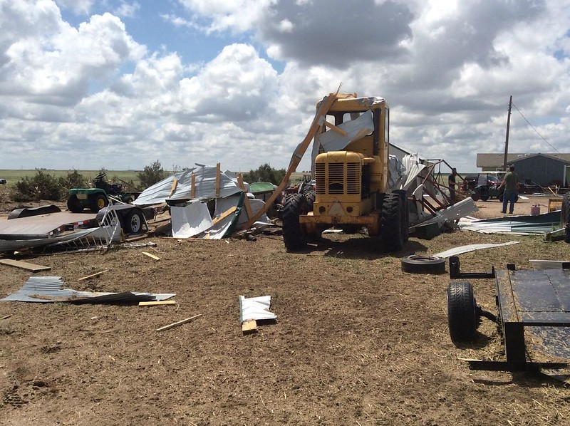
In 2001…large hail driven by strong thunderstorm winds raked Denver International and Front Range airports. Wind gusting to 54 mph along with hail as large 2 inches in diameter punched at least 14 thousand holes and cracks in the flat roofs of several buildings at Denver International Airport. In addition…93 planes and hundreds of cars were damaged. About 100 flights had to be cancelled…stranding 1500 travelers. The airport was completely shut down for about 20 minutes. The storm also damaged a ground avoidance radar used to track planes on the ground to prevent collisions. Damage was estimated at 10 million dollars…not counting the damage to the 93 airliners. The storm moved south and struck Watkins with hail as large as 2 1/2 inches in diameter and winds gusting to 60 mph. A least 30 private planes at Front Range airport were destroyed. The radome protecting the National Weather Service Doppler radar…which was tracking the storm…also sustained damage. The large hail…damaging winds… And heavy rain pummeled a mobile home park near Watkins. In the park…52 mobile homes… 14 recreational vehicles…3 homes… And a commercial building were damaged. Siding was riddled with holes and windows were broken. Vehicles sustained extensive damage and car windows were shattered. A handful of people were treated for minor cuts and bruises. The strong winds also flipped a tractor trailer along I-70 near Watkins. The storm caused power outages…which affected about 1200 residents. Excluding the damage at Denver International Airport…damage estimates totaled 49 million dollars…making the storm the costliest in the last 3 years and the 10th costliest since 1984. A small tornado touched down just east of Brighton… But did no damage. Hail as large as 2 inches in diameter fell near Fort Lupton with 3/4 inch hail measured in Bennett. Precipitation from the storm totaled only 0.23 inch at Denver International Airport.
In 2002…heavy rain fell near the Hayman wildfire burn area. Flash flooding washed out a 40-foot section of the access road to Cheeseman Reservoir. Some debris was washed against a gate…blocking the road. Hail to 1 1/2 inches in diameter fell near central city with 3/4 inch hail near Blackhawk.
In 2003…hail as large as 1 inch in diameter fell near Bennett and Strasburg with 3/4 inch hail measured in Denver…Golden… At Centennial Airport…and near Parker. Hail as large as 7/8 inch was reported in Arvada.
In 2004…a severe thunderstorm produced hail to 3/4 inch in diameter in and near Brighton.
In 2005…severe thunderstorms produced large hail near the palmer divide. Hail to 1 inch in diameter was measured near larkspur with 7/8 inch hail near Sedalia and 3/4 inch hail in Greenland. An apparent thunderstorm outflow produced a wind gust to 59 mph at Denver International Airport during the evening hours.
20-21
In 1897…high winds raked the city overnight. Southeast winds were sustained to 60 mph with gusts as high as 72 mph on the 20th. Southeast winds were sustained to 57 mph with gusts to 60 mph on the 21st.
In 2007…a brief hot spell produced two temperature records. The high temperature of 97 degrees was tied on the 20th. A new record high temperature of 99 degrees was established on the 21st.
Continue reading June 19 to June 25: This Week in Denver Weather History


 Extreme weather can occur during in month in Colorado we well know. June however is when traditional spring severe weather arrives in the state oftentimes with hail, damaging wind and tornadoes.