Severe weather is less common as we enter the fall season but it is not entirely unheard of. As we see in our look back at this week in Denver weather history, we have seen everything ranging from torrential rains to tornadoes and even heavy snow.
11
In 1910…west winds were sustained to 42 mph.
In 1951…a vigorous Canadian cold front produced a dust storm across metro Denver. Northeast wind gusts to 43 mph reduced the visibility at Stapleton Airport to as low as 1 1/2 miles for nearly 5 hours. The temperature dropped 47 degrees in 8 hours…from a high of 92 degrees to a low of 45 degrees.
In 1967…a microburst wind gust to 52 mph produced blowing dust and briefly reduced the visibility to 1/2 mile at Stapleton International Airport.
In 1974…a trace of snow…the first of the season…ended the shortest period without snow…94 days from June 9th through September 10th. A trace of snow also fell on June 8th.
In 1995…strong post-frontal winds associated with a fast moving pacific cold front knocked down power poles and trees as it moved through metro Denver. Numerous power outages affected nearly one thousand people in Denver and Jefferson counties. West winds gusted to 34 mph at Denver International Airport.
11-16
In 2013…a deep southerly flow over Colorado… Ahead of a nearly stationary low pressure system over the great basin… Pumped copious amounts of monsoonal moisture into the area. In addition…a weak stationary front stretched along the Front Range foothills and Palmer Divide. This resulted in a prolonged period of moderate to heavy rain across the Front Range foothills…Palmer Divide…urban corridor. By the 14th…storm totals ranged from 6 to 18 inches… Highest in the foothills of Boulder County. The headwaters then moved down the South Platte River and caused widespread flooding with record flood stages at several locations as it made its way downstream. The record high flood stages resulted in widespread flooding along the South Platte River basin. The flood damage encompassed 4500 square miles of the Front Range…left 7 dead… Forced thousands to evacuate…and destroyed thousands of homes and farms. Record amounts of rainfall generated flash floods that tore up roads and lines of communication… Leaving many stranded. Nearly 19000 homes were damaged… And over 1500 destroyed. Colorado department of transportation estimated at least 30 state highway bridges were destroyed and an additional 20 seriously damaged. Preliminary assessments of the state`s infrastructure showed damage of $40 million to roads and $112 million to bridges. Repair costs for state and county roads ran into the hundreds of millions of dollars. Miles of freight and passenger rail lines were washed out or submerged… Including a section servicing Amtrak`s iconic California Zephyr. The town of Lyons was isolated by the flooding of St. Vrain creek…and several earth dams along the Front Range burst or were over-topped. Floodwaters swept through Estes Park; damaged hundreds of buildings and destroyed large sections of U.S. 34 from Loveland and U.S. 36 from Lyons to Boulder. U.S. 34 suffered the most damage… With 85 percent of its roadway and bridges destroyed. In Weld County…about nearly two thousand gas wells were damaged and had to be closed off as the floodwaters inundated entire communities. Sewage treatment plants and other utilities were knocked out in a number of towns. Governor Hickenlooper declared a disaster emergency on September 13th…in 11 counties across northeast Colorado including: Adams…Arapahoe…Broomfield…Boulder…Denver… Jefferson…Larimer…Logan…Morgan… Washington and Weld. By the 15th…federal emergency declarations covered those counties as well as Clear Creek County. Projected losses from the flooding statewide was nearly two billion dollars in property damage…according to Eqecat… A catastrophe modeling firm. The damage was most severe in and around Lyons and Boulder. More than 11 thousand people were evacuated…reportedly the largest since Hurricane Katrina. President Obama declared a state of emergency for Boulder and Larimer counties. An additional 10 counties were added on the 16th and included: Adams… Arapahoe…Broomfield…Clear Creek…Denver…Jefferson… Morgan…Logan… Washington and Weld counties. The president also declared a major disaster specifically for Boulder County. There were six fatalities directly attributed to flash flooding. Two 19-yr old teenagers died on the 11th…after they were swept away by floodwaters after abandoning their car on Lindon Drive in Boulder. In Jamestown…a 72-yr old man was killed when the building he was in collapsed. An 80-yr old Lyons resident died in the early morning hours of the 12th…when his truck was swept into the St. Vrain River near his home. Later on the 12th…a 79-yr old Larimer County resident was killed when she was swept away while trying to climb to safety from her home in Cedar Point. A 61-yr old cedar point resident died when her home was swept down the Big Thompson River by the floodwaters. An 80-yr old Idaho Springs resident drowned in Clear Creek when the embankment he was standing on collapsed. In Boulder…some of the monthly records broken included: one-day all-time record: 9.08 inches which shattered the previous wettest day of 4.8 inches set on July 31… 1919; one-month record of 18.16 inches…which broke the previous all-time monthly record of 9.59 inches set in May of 1995; wettest September on record which broke the previous record of 5.5 inches set in September of 1940; one-year record of 34.15 inches broke the previous wettest year of 29.93 inches set in 1995. At Denver International Airport…the total precipitation for the month of September was 5.61 inches…which was 4.65 inches above the normal of 0.96 inches. This is the most precipitation ever recorded in Denver for the month of September. Daily precipitation records included 1.11 inches on the 12th and 2.01 inches on the 14th.
11-12
In 1974…post-frontal rain changed to snow overnight for the first snow of the season. Snowfall totaled only 1.8 inches at Stapleton International Airport where north winds gusted to 40 mph on the 11th. High temperature of only 46 degrees on the 12th set a new record low maximum for the date.
Continue reading September 11 to September 17: This Week in Denver Weather History
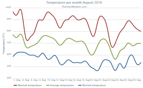
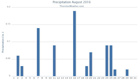
 Following on what was a cool but dry August, some are certainly hoping for a bit of precipitation. The month can bring plenty of rain and even our first snow of the season but more often than not, it is one of the most pleasant along the Colorado Front Range.