High pressure was the general rule for much of the month of June 2017. This resulted in overall average temperatures that were warmer than normal and precipitation that fell a good ways short of average.
The month was largely short on weather excitement, beyond the temps and lack of precipitation. The National Weather Service said that 23 of the 30 days saw above normal temperature readings. Denver recorded only five days with precipitation while in Thornton we saw eight.
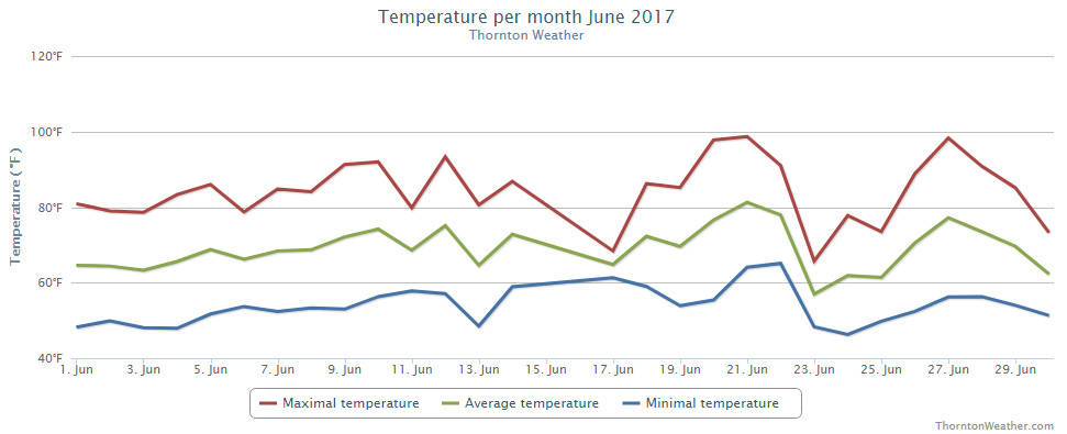
Thornton saw an overall average monthly temperature of 69.2 degrees. Out at DIA where Denver’s official measurements are taken, the Mile High City was close with an average of 69.5 degrees. Both locations’ readings were well above the long term June average of 67.4 degrees.
Temperatures in Thornton ranged from a high of 98.7 degrees on the 21st down to a low of 46.3 degrees on the morning of the 24th. Denver saw a maximum of 99 degrees on the 20th and a low of 42 degrees on the 13th.
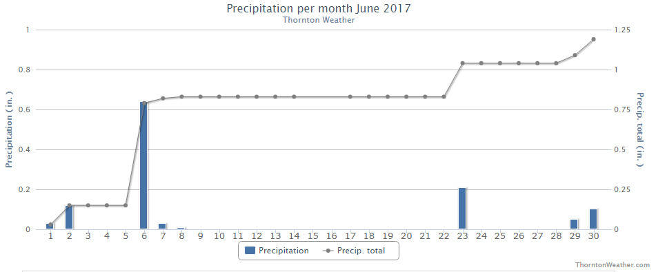
In terms of precipitation, Denver averages 1.98 inches during the month of June. Thornton fell short of the mark with 1.20 inches falling into our rain bucket while Denver’s reading was far worse with a mere 0.33 inches falling there.
Neither Thornton nor Denver saw any snowfall during the month.
Thornton, Colorado’s June 2017 temperature summary. (ThorntonWeather.com)Thornton, Colorado’s June 2017 precipitation summary. (ThorntonWeather.com)
From the National Weather Service:
CLIMATE REPORT
NATIONAL WEATHER SERVICE DENVER/BOULDER CO
729 AM MDT SAT JUL 1 2017

...................................

...THE DENVER CO CLIMATE SUMMARY FOR THE MONTH OF JUNE 2017...

CLIMATE NORMAL PERIOD 1981 TO 2010
CLIMATE RECORD PERIOD 1872 TO 2017

WEATHER         OBSERVED          NORMAL  DEPART  LAST YEAR`S
                 VALUE   DATE(S)  VALUE   FROM    VALUE  DATE(S)
                                          NORMAL
................................................................
TEMPERATURE (F)
RECORD
 HIGH             105   06/26/2012
                        06/25/2012
  LOW              30   06/02/1951

HIGHEST            99   06/20        96       3       98  06/21
LOWEST             42   06/13        42       0       49  06/02
AVG. MAXIMUM     85.5              82.4     3.1     85.5
AVG. MINIMUM     53.6              52.3     1.3     56.2
MEAN             69.5              67.4     2.1     70.8
DAYS MAX >= 90      9               7.9     1.1       12
DAYS MAX <= 32      0               0.0     0.0        0
DAYS MIN <= 32      0               0.0     0.0        0
DAYS MIN <= 0 0 0.0 0.0 0
PRECIPITATION (INCHES)
RECORD
 MAXIMUM 4.96 1882
 MINIMUM T 1890
TOTALS 0.33 1.98 -1.65 1.62
DAILY AVG. 0.01 0.07 -0.06 0.05
DAYS >= .01         5               8.4    -3.4        7
DAYS >= .10         2               4.6    -2.6        4
DAYS >= .50         0               1.4    -1.4        1
DAYS >= 1.00        0               0.3    -0.3        0
GREATEST
 24 HR. TOTAL    0.13   06/29 TO 06/29           06/13 TO 06/13

SNOWFALL (INCHES)
RECORD            0.5 1953
 TOTAL            0.0 2017          0.0

DEGREE_DAYS
HEATING TOTAL      25                62     -37        4
 SINCE 7/1       5109              6058    -949     5560
COOLING TOTAL     167               133      34      185
 SINCE 1/1        173               155      18      188

FREEZE DATES
RECORD
 EARLIEST     09/08/1962
 LATEST       06/08/2007
EARLIEST      04/01             10/07
LATEST        05/04             05/05
....................................................

WIND (MPH)
AVERAGE WIND SPEED              10.1
RESULTANT WIND SPEED/DIRECTION   2/135
HIGHEST WIND SPEED/DIRECTION    44/270    DATE  06/27
HIGHEST GUST SPEED/DIRECTION    66/270    DATE  06/27

SKY COVER
POSSIBLE SUNSHINE (PERCENT)   MM
AVERAGE SKY COVER           0.50
NUMBER OF DAYS FAIR            6
NUMBER OF DAYS PC             22
NUMBER OF DAYS CLOUDY          2

AVERAGE RH (PERCENT)     47

WEATHER CONDITIONS. NUMBER OF DAYS WITH
THUNDERSTORM             10     MIXED PRECIP               0
HEAVY RAIN                2     RAIN                       2
LIGHT RAIN                8     FREEZING RAIN              0
LT FREEZING RAIN          0     HAIL                       0
HEAVY SNOW                0     SNOW                       0
LIGHT SNOW                0     SLEET                      0
FOG                       3     FOG W/VIS <= 1/4 MILE      0
HAZE                      1

-  INDICATES NEGATIVE NUMBERS.
R  INDICATES RECORD WAS SET OR TIED.
MM INDICATES DATA IS MISSING.
T  INDICATES TRACE AMOUNT.
U.S. Vice President Mike Pence pledged to usher in a “new era” of American leadership in space during a tour of the Kennedy Space Center in Florida Thursday. “Our nation will return to the Moon, and we will put American boots on the face of Mars,” Pence told the cheering crowd of about 800 NASA employees,… Continue reading Pence Vows: ‘American Boots on the Face of Mars’→
July 2 to July 8: This Week in Denver Weather History
In our July weather preview we discussed how the month is not only Denver’s hottest but also its stormiest. Our look back at this week in Denver weather history helps to illustrate that fact. We start seeing 100+ degree days as well as many of the types of fast moving thunderstorm events expected this time of year.
From the National Weather Service:
29-2
In 1990…almost a year to date after the record breaking heat in early July 1989…the third longest heat wave in Denver history started. From June 29th through July 2nd the temperature reached 100 degrees or more on four consecutive days. The highest reading of 102 degrees occurred on the 29th…30th…and 1st. Combined with the 102 degree reading on June 27th this would have been the longest heat wave on record…but the temperature climbed to only 98 degrees on June 28th.
29-15
In 2000…the 29th marked the beginning of a near record hot streak for metro Denver. The high temperatures…as recorded at Denver International Airport…exceeded the 90 degree mark for 17 consecutive days from June 29th through July 15th. The record of 24 consecutive 90 degree or above days was set from July 13th through August 5th…2008.
1-18
In 1874…a streak of 18 consecutive days of 90 degrees tied for second with another streak that was later set in the summer of 1901. The record of 24 consecutive days was established in the summer of 2008.
1-31
In 2012…it was the hottest July on record in Denver since weather records began in 1872. The average temperature for the month was 78.9 degrees which was 4.7 degrees above normal. There were 27 days in which the high temperature equaled or exceeded 90 degrees…which established a new record. There were also 7 days in which the temperature equaled or exceeded 100 degrees which tied the record set in 2005.
2
In 1879…a severe hail storm produced considerable damage in the vicinity of Arvada. Some of the stones were unusually large…measuring 6.5 inches in circumference (2 inches in diameter) with an average weight of 1 ounce. The stones were uniformly large with one side concave. The greatest damage was to early wheat…cabbage…and vines. A tree just to the south of the weather station in downtown Denver was struck by lightning. Residents in the house 15 feet away were affected by the strike.
In 1885…thunderstorm winds were sustained to 50 mph in the city.
In 1892…an apparent cold front produced sustained northeast winds to 40 mph with gusts to 45 mph.
In 1955…a apparent microburst wind gust to 69 mph was recorded at Stapleton Airport where the brief strong wind reduced the visibility to zero in blowing dust.
In 1965…hail…up to 2 inches in diameter…struck southwest Adams and northeast Denver counties…damaging cars…windows… And foliage. Hail accumulated up to a foot deep. Wind gusts to 48 mph and hail to 1 inch in diameter fell at Stapleton International Airport where the large hail broke three storm windows and shredded shrubs at the U.S. Weather Bureau Upper Air building.
In 1968…a pilot reported a tornado 10 miles southeast of Parker.
In 1971…one inch diameter hail stones were reported in Adams County about 30 miles east of Denver.
In 1987…a large tornado touched down 10 miles northeast of Stapleton International Airport. The tornado was vertical and thick and kicked up a large dust and debris cloud. Later…it developed a sinuous rope-like shape as it slowly dissipated. The tornado was visible for 15 minutes. The twister occurred in open country and did only minor damage to a metal shed…porch…and mailbox. A man was killed by lightning in southwest Aurora. He was in his backyard and had a shovel in his hand at the time of the strike. A group of soccer players were hit by lightning on a field in Boulder. A 10-year-old boy was critically injured and hospitalized; fortunately he recovered. Six other people were knocked to the ground by the strike. Two of these were slightly injured. Golf ball size hail fell just east of Littleton and at Highlands Ranch. Hail as large as 3/4 inch in diameter was reported in Aurora and Parker and near Hudson and Franktown.
In 1988…a 45-year-old man was injured by lightning at Cheery Creek Reservoir. Administration of CPR probably saved his life.
In 1990…the temperature reached a high of 100 degrees at Stapleton International Airport.
In 1993…thunderstorm winds blew a roof off a barn near Parker…causing an estimated 15 hundred dollars damage.
In 1994…thunderstorm winds downed power lines in Boulder… Causing power outages. Winds gusted to 66 mph in Boulder… 64 mph in Arvada…and 60 mph in Golden.
In 1998…a small tornado touched down briefly near Barr Lake… But caused no damage.
In 2002…hail as large as 1 3/4 inches in diameter fell in the city of Denver and in Arapahoe County near Littleton. The low temperature of 69 degrees equaled the record high minimum for the date.
In 2006…lightning struck a teenager in Castle Rock as he was mowing his lawn and listening to an iPod. The teen suffered burns to his hands and feet…and had blood running from his ears when he was found. The victim’s eardrums were ruptured…which damaged his hearing. Lightning also struck a house in Castle Rock causing extensive damage to the roof and side of the home. Heavy rains caused flash flooding at Castlewood Canyon State Park near Franktown. The floodwaters destroyed four footbridges along the high trail. A culvert and several roads were washed out in the area. In addition… Two driveways crossing Cherry Creek were washed out near Prairie Canyon Ranch. Heavy rainfall also caused minor flooding on murphy and sand creeks…just east of Buckley AFB. Gun Club Road was closed between Alameda and Mississippi avenues…north of the Murphy Creek Golf Course…where 3 feet of standing water reportedly covered the road. A severe thunderstorm produced large hail to 7/8 inch in diameter in south Aurora near Cherry Creek.
3
In 1874…the temperature climbed to a high of 101 degrees in downtown Denver.
In 1881…the all time highest recorded daily minimum temperature of 77 degrees occurred in the city. This was also the highest daily minimum temperature ever recorded in July.
In 1885…a severe thunderstorm produced hail the size of hazel nuts…which fell with great force. A telegraph pole in west Denver was struck by lightning and shattered to pieces.
In 1955…a brief microburst wind gust to 61 mph was recorded at Stapleton Airport.
In 1960…a major hail storm caused 1.5 million dollars in damage across metro Denver. The heaviest damage occurred in south Denver…Englewood…Littleton…and Golden from wind- driven hail as large as golf balls and heavy rain which caused flooding. Winds were estimated at 60 to 70 mph. Rainfall was estimated at 2 to 3 inches. Hail accumulated 3 to 4 inches deep in some sections. Hail carried by flood waters drifted 3 to 4 feet deep. An Englewood policeman was injured when hail broke the windshield of his car. One inch of rain in 10 minutes…and heavy hail damage were reported in Parker. At some places the hail from the storm was still on the ground the next morning.
In 1967…large hail stones from 1 3/4 to 2 1/2 inches in diameter damaged cars and buildings in southwest Denver and Littleton where hail drifted to depths of 3 to 4 feet. The hail caused a great deal of damage…and streets were flooded by heavy rain over many sections of west metro Denver. At centennial race track near Littleton…a few hail stones were as large as tennis balls. Large hail broke the windshield on a Littleton police car. Golf ball to tennis ball size hail fell in the vicinity of Arapahoe road and south Broadway. One inch diameter hail fell at the intersection of orchard and south university. Golf ball size hail fell in Broomfield. Hail in Westminster was measured from 1 to 1 1/4 inches in diameter. Tornadoes were sighted by the public near Cheery Creek Reservoir… north of Commerce City…and in Arvada…but caused no reportable damage.
In 1993…high winds developed behind a strong cold front along portions of the Front Range. While the strongest winds were reported north of metro Denver…the winds blew out a half inch thick pane of glass from a vacant 9-story building. The glass landed on a parked car below. West winds gusting to 52 mph kicked up some blowing dust at Stapleton International Airport.
In 1996…lightning sparked a small fire near buffalo creek in southern Jefferson County. Only one acre burned before the fire was contained.
In 2002…heavy thunderstorm rain washed out a frontage road 6 miles north of Larkspur. The nearby mountain ranch subdivision was also flooded. Heavy rainfall in the Hayman fire burn area washed out a secondary road when debris from the runoff blocked a culvert. Hail as large as 3/4 inch fell near Keenesburg…in Castle Rock…and 7 miles to the south of Castle Rock.
In 2005…severe thunderstorms produced high winds. Wind gusts to 75 mph were measured near Longmont and to 60 mph just west of Boulder. No damage was reported.
In 2007…severe thunderstorms produced large hail in the foothills and suburbs west of Denver. Large hail from 1 to 2 inches in diameter was reported in the vicinity of Idaho Springs…Rollins and Edgewater.
In 2009…severe thunderstorms produced large hail and north and east of Denver. Hail up to one inch in diameter was observed near Erie and firestone. Hail up to 1 3/4 inches was observed 5 to 6 miles west-southwest of Byers. The golfball size hail caused extensive damage to a wheat field. In Aurora…six children received minor injuries when lightning struck a nearby tree. The injuries occurred when they were knocked down by the blast. None of the children suffered burns or appeared to have been directly hit by lightning.
In 2014…a severe thunderstorm produced large… up to 1 ½ inches in diameter…about 14 miles northwest of Golden.
Change is of course the one constant in Denver’s weather but come July, things actually get pretty consistent.
The standard formula for a day in July is a sunny morning, clouds developing in the late morning and early afternoon. Come mid-afternoon, thunderstorms are rolling off of the foothills and into the metro area and the eastern plains. These storms do occasionally reach severe status containing hail, gusty winds and heavy downpours of rain.
WASHINGTON — With wildfire season raging in western states, Congress is embroiled in a battle over how best to fight the fires. Many Republicans want to help prevent and fight wildfires by giving the agencies that manage the federal forests more money and greater ability to thin out the forests. Most Democrats, as well as environmental… Continue reading As wildfires rage in West, DC lawmakers fight over forest policy→
June 25 to July 1: This Week in Denver Weather History
Our look back at this week in Denver weather history certainly has plenty of the usual suspects related to severe weather. Most notable however are the many occurrences of lightning strikes and the effects they can have from sparking fires to causing significant injury and death.
From the National Weather Service:
22-26
In 2012…the maximum temperature exceeded 100 degrees for five consecutive days. Two of the high temperatures on the 25th and 26th peaked at 105 degrees…which set the all time record for the month of June and tied the all time maximum temperature for Denver.
25
In 1873…forest fires produced a great deal of smoke in the mountains to the southwest of the city.
In 1958…an unusually cold day for summer set two temperature records for the date. Under cloudy skies with occasional drizzle…a record low maximum temperature of 55 degrees was established along with a record minimum temperature of 42 degrees.
In 1959…a waitress…working at a kitchen sink… Was injured by a bolt of lightning…which struck the rear of a tavern in Denver. She was hospitalized.
In 1971…a tornado touched down briefly at a high school football field in Brighton…but caused no damage.
In 1981…3/4 inch hail pelted Wheat Ridge and hail to 1 1/4 inches fell in Louisville. A brief funnel cloud was sighted by national weather service personnel 4 miles east of Stapleton International Airport.
In 1982…a bolt of lightning struck a cabin in the foothills west of Denver. The resulting fire totally destroyed the cabin.
In 1987…golf ball size hail fell near Bennett.
In 1988…a tornado touched down 1 mile south of Watkins and was on the ground for 4 minutes. Another tornado was spotted just southeast of Barr Lake and was on the ground for 5 minutes. No damage was reported from either tornado. Lightning struck two rock climbers near Eldorado Springs. A 25-year-old man was killed…and a 21-year-old man suffered extensive injuries. Thunderstorm winds knocked over two elm trees near downtown Denver. One fell on a house destroying most of it. A nearby building was unroofed…and two cars were damaged. A truck that had been severely damaged by one of the Denver tornadoes 10 days before was hit again. Thunderstorm wind gusts to 51 mph were recorded at Stapleton International Airport.
In 1991…the temperature reached a high of 100 degrees… Setting a new record for the date.
In 1997…one inch diameter hail fell in Arvada and 1 1/2 inch hail in Boulder. Hail as large as 3/4 inches fell in Denver…Louisville…Westminster… And near Broomfield.
In 1999…thunderstorm winds gusted to 58 mph near Fort Lupton toppling an oil rig. A 37-year-old man was killed when he fell 55 feet from the derrick of the rig.
In 2001…four golfers and one construction worker received minor injuries from a nearby lightning strike on the Broadlands Golf Course in Broomfield.
In 2002…hail to 1 inch in diameter was measured in greenwood village.
In 2005…hail to 3/4 inch in diameter fell near Bennett and Roggen. A thunderstorm wind gust to 61 mph was recorded near Golden.
In 2009…lightning struck the Darlington Prismatic Electric Fountain in City Park`s lake. The damage was estimated to be approximately $25000.
In 2010…wind gusts associated with a dry microburst downed several trees in the vicinity of 14th and federal…and near Bayaud St. and Clarkson St. in Denver. At Denver International Airport…a peak wind gust to 45 mph was observed from the southwest.
25-26
In 1969…high winds raked Boulder causing one fatality and some injuries. One man was injured by a falling tree limb. At the National Center for Atmospheric Research in Boulder… Sustained winds of 55 to 60 mph with wind gusts to 123 mph were recorded. In downtown Boulder…winds averaged 30 to 40 mph with gusts to 70 mph. Widespread minor damage occurred… Especially in the Table Mesa area of south Boulder. Much tree damage occurred in the older areas of Boulder where several trees were uprooted. A mobile home was overturned by the winds. At Stapleton Airport…west winds gusted to 43 mph on the 25th and 37 mph on the 26th.
In 1975…strong winds damaged utility lines…buildings… Vehicles…trees… And power lines in Boulder and other communities to the north of Boulder. Microburst winds gusted to 45 mph at Stapleton International Airport on the 25th.
In 1983…heavy rain fell in the foothills west of Denver with 1.50 inches in 30 minutes at Intercanyon. Heavy rain continued over metro Denver on the 26th with two-day storm totals at many locations ranging from 1.00 to 2.50 inches. Rainfall totaled 1.37 inches at Stapleton International Airport on the 26th.
In 1985…one to two inches of rain fell over metro Denver. At Stapleton International Airport…rainfall totaled 0.93 inches…thunderstorm winds gusted to 44 mph… And 7/10 inch hail was measured. The air mass was unusually cold for the season…and snow fell in the foothills above 8 thousand feet. The high temperature of only 63 degrees on the 26th equaled the record low maximum reading for the date.
26
In 1873…there was a great deal of smoke from a large forest fire in the mountains to the southwest of the city and a smaller fire directly to the west.
In 1874…fires at timberline to the west were visible from the city. New and extensive fires were continually started from south to northwest along the ridge line. Carelessness of tourists was the apparent cause of the fires. Large and valuable tracts of timber had already been destroyed.
In 1890…the only thunderstorm of the month produced a trace of rain. A trace of rain also fell on 7 other days. This was the only precipitation recorded during the month… Making it the driest June on record.
In 1893…northwest winds were sustained to 45 mph with gusts to 48 mph.
In 1971…a microburst wind gust to 58 mph was recorded at Stapleton International Airport. Dust devils were sighted.
In 1980…strong gusty thunderstorm winds damaged several mobile homes in Thornton. Thunderstorm winds gusted to 37 mph at Stapleton International Airport.
In 1986…hail piled up 1 1/2 inches deep in Golden Gate Canyon and covered roadways an inch deep in Evergreen.
In 1988…a tornado touched down 2 miles north of Watkins. It was on the ground for 15 minutes and did no reported damage.
In 1989…two inch diameter hail fell at Kassler…1 inch hail at Louviers…and 1 1/2 inch hail at tiny town.
In 1991…high winds…not associated with thunderstorms… Damaged a home in the Green Mountain area. The strong winds picked up a heavy metal and glass table on the deck of a house and threw it into the house. The table was destroyed and the house received considerable damage.
In 1992…3/4 inch diameter hail fell in south Aurora and near Buckley Air National Guard base. Golf ball size hail was reported in Parker.
In 1994…the all-time highest recorded temperature in June and the second highest temperature ever recorded in Denver… 104 degrees occurred. This was the hottest day in Denver since August 8…1878…when the temperature reached 105 degrees.
In 2005…strong thunderstorm winds gusting to 58 mph damaged a garage and some nearby trees near Fort Lupton. Winds also gusted to 58 mph near Watkins. Thunderstorm winds gusted to 60 mph near Roggen. Hail to 3/4 inch in diameter was measured in southwest Aurora.
In 2009…severe thunderstorms moving through Denver and the surrounding metro area produced intense thunderstorm winds. At Denver International Airport…a wind gust blew a luggage car into a southwest airlines airplane causing some damage. Peak wind gusts included: 68 mph at Denver International Airport…4 miles west of rocky mountain metropolitan airport and 12.5 miles north of Lowry AFB; 64 mph near Arvada and Parker; and 60 mph in Aurora/cherry.
26-27
In 1965…wind gusts to 38 mph were recorded in downtown Boulder…causing widespread minor damage. A microburst wind gust to 41 mph was recorded at Stapleton International Airport.
27
In 1873…Pikes Peak was hidden from view by smoke from forest fires in the mountains to the southwest of the city.
In 1927…the temperature cooled to a low of only 72 degrees… The all-time record high minimum for the month.
In 1980…lightning injured 4 people on a baseball diamond in Broomfield. The bolt seriously injured the pitcher while also striking (out) the batter…catcher and second baseman.
In 1987…a microburst wind gust to 53 mph was recorded at Stapleton International Airport.
In 1990…the temperature reached a high of 102 degrees… Setting a new record maximum for the date.
In 1993…thunderstorm winds gusted to 60 mph across parts of metro Denver. A wind gust to 50 mph blew over a 30-foot canvas tent at an amusement park southeast of Denver. Fifteen people…mostly children…were injured. Microburst wind gusts to 33 mph were recorded at Stapleton International Airport.
In 2002…heavy rain…up to 3/4 inch…fell across sections of the Hayman burn area near Cheeseman Reservoir. Several forest service roads were washed out and many culverts were plugged by debris.
In 2004…heavy rain producing thunderstorms caused rock and mud slides across the overland fire burn area in Jamestown. An estimated 50 tons of sand…dirt…rock…and ash slid into town…filling a culvert under main street. The slide covered 150 to 225 feet of main street. The flood was produced by half an inch of rain in 30 minutes. A deluge of very heavy rainfall from nearly stationary thunderstorms caused flooding and flash flooding problems over parts of Jefferson and Douglas counties. An automated rain gage in Golden measured 3.60 inches of rainfall in one hour. Numerous homes were flooded in Golden…including one that was 146 years old. The home was listed as a complete loss. State Highway 93 had to be closed from the Pine Ridge subdivision to the Golden Gate Canyon Road. At the height of the storm…about 4 feet of water covered State Highway 93 through Golden… Forcing its temporary closure. Several intersections were also flooded and impassable. Rock and mud slides were reported in Golden Gate Canyon state park. At the Deer Creek Golf Course at Colorado 470 and Kipling…the greens were completely inundated by floodwaters. Some backyards near the golf course were partially washed out. In Douglas County…water up to a foot deep covered the roadways in Roxborough State Park. The Waterton Canyon Road also had to be closed due to high water.
In 2010…a severe thunderstorm produced hail up to 1 inch in diameter near Strasburg. Hail up to 3/4 inch in diameter was reported in Aurora and Buckley Air Field.
Over 800 earthquakes have now been recorded at Yellowstone supervolcano over the last two weeks, with the ongoing swarm taking place on the western edge of the National Park. But there is virtually no risk of the volcano erupting, the United States Geological Survey (USGS) currently lists the volcano alert level as normal and the aviation… Continue reading Over 800 Earthquakes Recorded at Yellowstone Volcano→
We knew it would be hot today and the proof is in the numbers as Denver set a new record high temperature for the date.
According to the National Weather Service, the mercury topped out at 99 degrees at Denver International Airport. This breaks the previous record high for June 20 of 97 degrees set in 2007.
Here in Thornton, we almost matched the record with a high of 97.9 degrees at 3:57pm.
There will be no break from the heat until Friday.
Tomorrow’s forecast high of 98 degrees mirrors today’s high and will again come close to the record for June 21 (99 degrees in 2007). Thursday does cool some but with a forecast high of 91 degrees, the reading will still be well above normal for the date (85 degrees).
Stay up to date with Thornton’s weather: Be sure to ‘like’ us on Facebook, follow us on Twitter and add us to your Google+ circles.
Yellowstone supervolcano has been hit by a series of earthquakes, with more 30 recorded since June 12. The latest was recorded on Monday, June 19, with a magnitude 3 earthquake striking 8.6 miles north north-east of West Yellowstone, Montana. The swarm began last week, and on June 15 saw a magnitude 4.5 earthquake take place in… Continue reading Yellowstone Supervolcano Hit by a Swarm of Earthquakes→
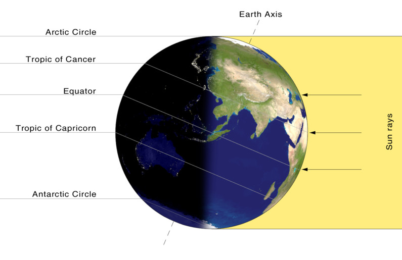
On the June solstice, the Earth’s northern hemisphere is tilted at its maximum toward the sun. The result is the longest day of the year for the northern part of the planet. (NASA)
Astronomical summer arrives in Thornton tonight and with the solstice we will enjoy our longest day of the year.
Summer officially begins at 10:24pm MDT tonight. The Summer Solstice occurs when the North Pole is tilted at it closest to the sun – 23.4 degrees. This results in the longest day of the year in the Northern Hemisphere.
Here in Denver the sun rises at 5:32am today and sets at 8:31pm. This will give us 14 hours, 59 minutes and 14 seconds of daytime. Tomorrow it will be a bit less than one second shorter than today and each day from now through the Winter Solstice in December will get gradually shorter as well.
At the poles of the globe, the seasonal extremes will be quite notable. Areas north of the Arctic Circle to the North Pole will see 24 hours of daylight and have a midnight sun. On the opposite end of the globe, the South Pole will have no direct sunlight at all as they are in the depths of their winter.
Did you know that there is a difference between the astronomical seasons that we are discussing here and meteorological seasons?
Meteorological seasons differ slightly and are geared toward matching the calendar with the annual temperature cycle. This is done primarily for meteorological observing and forecasting and in many ways it is more logical than the astronomical seasons.
For the Northern Hemisphere, the meteorological spring covers the months of March, April and May. Summer brings the hottest months of the year and so meteorological summer is June, July and August. Meteorological fall then is September, October and November followed by the coldest months of December, January and February as meteorological winter.
Weather, natural disasters & climate news and information.