Category Archives: Thornton Weather

Thornton’s September weather preview posted

Denver & Thornton Climatological Preview - September 2009

As temperatures start to drop, September reminds us that summer is at an end and fall is now here. Sunshine is predominant though as the month actually has the highest percentage of sun out of any month. Sunny days and clear, cool nights are the standard weather pattern for the month.

Normal highs on the first of the month are 82 degrees with a low of 53. By the end of the month we see those high temperatures drop to an average of 73 and the lows get to a chilly 42. Overall the month averages 62.4 degrees.

Click here to get all the details on Thornton’s September weather.

August 30 to September 5 – This week in Denver weather history
August 30 to September 5 – This week in Denver weather history.

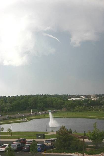
As always, when looking at weather history we are reminded of the varied and sometimes dangerous weather conditions we have here in Colorado.  Our look this week we see high temperatures soaring to 97 degrees but also we see the earliest snowfall on record.

From the National Weather Service:

19-30

In 1875…grasshoppers appeared in great numbers at 10:00 am on the 19th.  Thousands landed on the ground.  The streets were literally covered with them.  Swarms of grasshoppers were seen on each day.  All gardens in the city were devastated…and in the countryside the grasshoppers were very destructive to ripened grain.  On the 30th the grasshoppers were so numerous as to almost darken the sun.

30

In 1981…60 mph winds were reported in Boulder.
 
In 2004…a severe thunderstorm produced hail as large as 1 inch in diameter in south Aurora near Cherry Creek.

31

In 1951…hail as large as 1 3/4 inches in diameter caused an estimated 300 thousand dollars damage in metro Denver. Hail as large as 1 1/2 inches in diameter was measured at Stapleton Airport.
 
In 1978…strong thunderstorm winds tore the roof off an apartment building in Aurora…downed trees…and damaged windows in Denver.  A microburst wind gust to 58 mph was recorded at Stapleton International Airport.
 
In 1985…a thunderstorm wind gust to 60 mph was clocked at Buckley Field in Aurora.
 
In 1997…hail to 1 1/4 inches in diameter was measured in Aurora.
 
In 2006…a female postal worker was struck and injured by lightning while delivering mail in Westminster.
 
In 2008…lightning struck a home in Brighton…damaging the roof and a bedroom.  The damaged totaled 20 thousand dollars.

Continue reading August 30 to September 5 – This week in Denver weather history

August 23 to August 29 – This week in Denver weather history

August 23 to August 29 – This week in Denver weather history
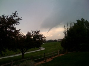

Quite the interesting week in Denver weather history.  Swarms of grasshoppers are the most unusual item we see but there is plenty of standard severe weather including tornadoes, landspouts, hail, lightning and much more.

From the National Weather Service:

19-30

In 1875…grasshoppers appeared in great numbers at 10:00 am on the 19th.  Thousands landed on the ground.  The streets were literally covered with them.  Swarms of grasshoppers were seen on each day.  All gardens in the city were devastated…and in the countryside the grasshoppers were very destructive to ripened grain.  On the 30th the grasshoppers were so numerous as to almost darken the sun.

22-24

In 1987…some locations in metro Denver had a total 3-day rainfall of 2 to 4 inches.  Rainfall totaled 0.96 inch at Stapleton International Airport.

23

In 1900…northwest winds were sustained to 42 mph with gusts to 49 mph.
 
In 1921…a thunderstorm cloudburst produced 2.20 inches of rainfall in an hour over downtown Denver.  This is the greatest 1 hour rainfall on record at the official observing site in the city.  Precipitation totaled 2.93 inches…which is the greatest calendar day precipitation ever recorded in august.
 
In 1941…one man was killed by lightning about 2 miles from the official weather station in downtown Denver.
 
In 1962…a home near Boulder was destroyed by a lightning- caused fire.
 
In 1968…strong winds buffeted Boulder briefly during the early morning hours.  At the National Center for Atmospheric Research…winds averaged 55 mph with gusts to 85 mph.  Damage was minor.  Northwest winds gusted to 31 mph at Stapleton International Airport.
 
In 1977…lightning damaged at least 6 homes in Aurora.
 
In 2008…a landspout touched down near Westcreek in Douglas County.  One man was seriously injured when he tried to escaped several falling trees in his ATV.  One of the trees struck his back and broke two vertebra.  Another camper narrowly escaped injury.  Seconds after he back up his truck…a tree came down where it had been parked.

Continue reading August 23 to August 29 – This week in Denver weather history

Hurricane Bill now a Category 3 as Bermuda issues warnings

Hurricane Bill on Thursday morning is seen as it nears the United States.

Wind shear helped to slow Hurricane Bill’s wind speeds to Category 3 levels of 125 mph over the last 24 hours. However, the National Hurricane Center cautions that some strengthening is expected in the next 24 hours and Bill may return to Category 4 levels.

The storm now has hurricane force winds extended out 85 miles from its center and tropical storm winds extending out 230 miles. Moving toward the northwest at 18 mph, the effects of the season’s first major Atlantic hurricane will begin to be felt in the next 72 hours.

The Bahamas and Bermuda will begin to experience large swells in the next 24 to 48 hours. Portions of the United States east coast will also feel similar effects Friday into Saturday. The National Hurricane Center is cautioning residents of these areas that ocean waters will be “extremely dangerous” with “life-threatening rip currents.”

For more information:

There's more to this story on the Denver Weather Examiner's site!There is much more to this story including latest images and forecast tracks on Examiner.com.

August 16 to August 22 – This week in Denver weather history

August 16 to August 22 - This week in Denver weather history

August is usually considered one of the calmer weather months in Denver but as our look back in weather history for this week shows, that isn’t always the case.  Thunderstorms and all their associated dangers – lightning, flooding, tornadoes and more – all present a very real danger even this time of year.

From the National Weather Service:

16

In 1902…a thunderstorm produced west winds sustained to 48 mph with gusts to 60 mph…but only a trace of rain.
 
In 1952…a thunderstorm wind gust to 50 mph was recorded at Stapleton Airport.
 
In 1960…lightning struck a warehouse in central Denver… Causing 8 thousand dollars in damage to the building and stored electrical equipment.
 
In 1975…large hail…1 1/2 to 1 3/4 inches in diameter…fell about 4 miles north of Castle Rock.  Hail caused some minor damage in Aurora.  A funnel cloud was reported 25 miles east of Denver near Bennett.
 
In 1981…a tornado touched down briefly in open country just to the east of Aurora.  No damage was reported.
 
In 1982…a thunderstorm wind gust to 61 mph was recorded at Buckley Field in Aurora.  At the same time almost an inch of rain flooded and closed streets in south Aurora.  A women was hit by lightning just north of Denver.  A house in the area was also struck.
 
In 1985…a thunderstorm produced strong wind gusts over southern metro Denver.  One strong wind gust hit Cheery Creek Reservoir…capsizing a boat and drowning a man.  The wind gusts…clocked as high as 50 mph…also downed a few trees.
 
In 1989…1 3/4 inch diameter hail fell at Intercanyon in the foothills of Jefferson County.
 
In 1990…lightning caused minor damage to a south Aurora home.  No injuries were reported.
 
In 1994…strong thunderstorm winds caused damage in southern Weld County near Hudson and Fort Lupton.  Two mobile homes were destroyed and a few lost their roofs.  Up to 20 downed power poles and the destruction of two 115 thousand-volt towers caused widespread power outages.  Thunderstorm gust front winds from the north gusted to 48 mph at Stapleton International Airport.
 
In 2000…lightning ripped most of the roof from a home in southeast Aurora.  The bolt sparked a fire which destroyed the residence.  Damage was estimated at 250 thousand dollars.
 
In 2002…the temperature climbed to a maximum of 100 degrees setting a new record high for the date.
 
In 2003…a teenager was injured when he was struck by lightning while camping at Herman Lake…13 miles northwest of Georgetown.  The boy was knocked unconscious and suffered minor injuries.

16-19

In 1979…heavy thunderstorm rains on each of 4 consecutive days dumped a total of 2.62 inches of rain on Stapleton International Airport.  The heaviest rain…1.05 inches… On the 19th was accompanied by 1/4 inch diameter hail.

Continue reading August 16 to August 22 – This week in Denver weather history

August 9 to August 15 – This week in Denver weather history

August 9 to August 15 - This week in Denver weather history

Denver and Colorado as a whole are known for their unusual weather.  This week in particular is notable for one extraordinary event in weather history – clouds of grasshoppers!

8-10 

In 1979…heavy thunderstorm rains on each of three consecutive days dumped a total of 2.22 inches of rain at Stapleton International Airport.  The heaviest rain… 0.95 inches…fell on the 9th.  Small hail to 1/8 inch diameter fell on the 8th.

8-13 

In 1875…clouds of grasshoppers were seen flying through the air on the prevailing winds during each day.

9    

In 1900…a thunderstorm produced west winds sustained to 47 mph with gusts to 55 mph…but only 0.01 inch of rain.
 
In 1902…a thunderstorm produced no rain and north winds sustained to 52 mph with gusts to 60 mph.
 
In 1934…heavy cloudbursts in the foothills near Kittredge and at the head of Mount Vernon creek caused flash flooding on both bear creek and Mount Vernon Creek at Morrison… Which resulted in 6 deaths and much property damage. The highway in Mount Vernon Canyon was destroyed by the flood waters.
 
In 1981…3/4 inch hail fell at Kittredge near Evergreen in Jefferson County.
 
In 1987…3/4 inch hail fell in Boulder and 9 miles northwest of Castle Rock.
 
In 1995…lightning struck a 16-year-old counselor in the back of the head while he and a friend were standing under a tree at the singing river ranch…7 miles west of Evergreen.  He stopped breathing…but his friend was able to summon help and they were able to revive him.  He was hospitalized for a few days and released.
 
In 1998…brief…weak tornadoes (f0) were sighted near Bennett and Roggen.  No damage was reported.  Hail as large as 1 inch diameter fell in Franktown with 3/4 inch diameter hail measured near Castle Rock. Thunderstorm winds gusted to 61 mph near Roggen.

Continue reading August 9 to August 15 – This week in Denver weather history

August 2 to August 8 – This week in Denver weather history

August 2 to August 8 - This week in Denver weather history

On first glance our look at this week in Denver weather history appears to be less eventful than many we have looked at previously.  However, the severity of the events that appear on the historical weather calendar this week are enough to make you stand up and pay attention.  While August is typically a pretty quiet weather month, it is clear that severe weather can certainly strike and Thornton is mentioned in more than one significant event.

From the National Weather Service:

2    

In 1878…the high temperature reached 100 degrees in downtown Denver.
 
In 1911…an apparent dry microburst produced sustained west winds to 42 mph.
 
In 1972…one workman was killed and another injured when a strong gust of wind destroyed a partially completed apartment building in south Denver.  Hail to 1 3/4 inch diameter fell in Golden.
 
In 1973…hail to 3/4 inch diameter was reported in Boulder.
 
In 1986…a major outbreak of severe thunderstorms occurred along the Front Range.  Thunderstorms developed explosively.  Some places were hit by large hail twice. Two inch diameter hail broke car windows on I-25 west of Brighton…and up to 1 1/4 inch hail broke windows in Thornton.  Baseball size hail damaged several planes near Watkins.  Funnel clouds were sighted around Aurora.  Hail over 1/2 inch in diameter covered the ground 3 to 4 inches deep at Hudson northeast of Denver.  Most of the hail fell north of metro Denver…but 3/4 inch diameter hail was measured at Stapleton International Airport.  Total damage from the hail storms this day was estimated at over 10 million dollars.
 
In 1991…late afternoon thunderstorms produced heavy rain across metro Denver.  Two feet of water covered parts of I-25 in southeast Denver…while one foot of water covered parts of U.S. Highway 285 in Englewood.  Thunderstorm rainfall totaled 0.50 inch at Stapleton International Airport.
 
In 2001…severe thunderstorms producing heavy rain and hail… Either washed out or damaged several County roads in the Watkins and Bennett areas.  A small tornado (f0) touched down near Bennett…but did no damage.  Hail as large as 1 3/4 inches in diameter fell near Watkins.  One inch diameter hail was measured near Hudson and Keenesburg.
 
In 2008…strong winds blew several trees down in Denver… Damaging homes and downing power lines.  A peak wind gust of 67 mph occurred at Centennial Airport…with gusts to 60 mph estimated in Denver.  A peak wind gust of 37 mph was measured at Denver International Airport.  An elderly man was killed when a wind damaged tree broke free and crushed him while he attempted to remove it.  The downed power lines caused outages to about 500 Xcel energy customers.

Continue reading August 2 to August 8 – This week in Denver weather history

A new record low maximum temperature set & snow comes to the mountains

Denver has record setting cool temperatures and snow arrives in the Rocky Mountains.  Image courtesy Victor Lewis.
Denver has record setting cool temperatures and snow arrives in the Rocky Mountains. Image courtesy Victor Lewis.

While some parts of the nation experience record setting heat, on Thursday Denver had the opposite problem. The high temperature as measured at Denver International Airport reached a mere 64 degrees. This was two degrees below the previous record low maximum temperature of 66 degrees for this date set in 1925 and previous years. That is also an amazing 24 degrees below the normal temperature for this time of year!

Here in Thornton, we were even cooler than the official temperature on Thursday as the mercury climbed to a mere 61.3 degrees! 

The unseasonably cold weather has also brought an unusual sight to the Colorado mountains in July – snow! Some northern parts of the Rocky Mountains in the state above 12,000 feet received a couple inches of snow.

August 2009 climate and weather preview posted

Thorntons August weather preview.
Thornton's August weather preview.

As summer vacations wind down and families prepare to send their kids back to school in August, Colorado weather also starts to settle down. The chances for severe weather decrease markedly during August and by the end of the month daytime temperatures are dropping quite a bit as well.

At the start of the month Denver usually averages around 88 degrees for a high temperature. By the end of August that drops to 82 degrees. Similarly, nighttime lows drop from 60 to 53 from the start to the end of the month. Generally clear skies can be expected between midnight and noon but the afternoon often brings showers and thunderstorms. These storms typically develop over the foothills then bring precipitation to the Denver metro area.

Despite that moisture, the chance for severe weather decreases considerably compared to the first two months of summer. Cooler air near the surface helps to create a stable atmosphere thus keeping thunderstorms from usually becoming too intense. After the middle of August, tornadoes and damaging hail are pretty rare. The slow movement of storms this time of year are more likely to produce potentially heavy rain.

Click here to read the complete preview including a look back at what was a record setting month last year.

July 26 to August 1 – This week in Denver weather history

July 26 to August 1 - This week in Denver weather history

Weather can be deadly – we are all well (hopefully) aware of that.  Looking at this week in Denver weather history we are reminded of that and the tragedy that weather can bring to our state.  We see numerous cases of lightning causing death and injury but no one incident highlights the dangers of weather more than what occurred on July 31, 1976.  The Big Thompson Flood was Colorado’s worth weather-related disaster and claimed 144 lives.  More details on all these events are below.

13-5 

In 2008…a streak of 26 consecutive days of 90 degrees shattered the previous record of 18 consecutive days established in 1901 and 1874.   Ironically…no new single day record high temperatures were set in the month of July. In August however…a record of 104 degrees was set on the 1st…and another record of 103 degrees was set on the 2nd. In addition…a record low min of 70 degrees was set on August 2nd.

26   

In 1891…a thunderstorm produced sustained northeast winds to 44 mph with gusts to 60 mph and 0.16 inch of rain.
 
In 1894…a thunderstorm produced sustained southwest winds to 36 mph with gusts to 58 mph…but only 0.04 inch of rain.
 
In 1910…the high temperature reached 100 degrees in downtown Denver.
 
In 1959…a Denver man was stunned while standing by a car that was struck by lightning.  He was treated for burns and shock at a local hospital.  Thunderstorm winds gusted to 55 mph at Stapleton Airport.
 
In 1983…two heavy thunderstorms hit the northern and western suburbs.  The first drenched Northglenn with an inch of rain in 30 minutes.  The second storm dumped an inch or more of rain in Idaho Springs and Evergreen.  The heaviest rainfall… 2.90 inches in an hour…caused minor street flooding in Golden.
 
In 1984…heavy early morning thunderstorms drenched the foothills southwest of Denver.  Rainfall to 1 1/2 inches in just 30 minutes occurred between Evergreen and Conifer.  In nearby turkey creek canyon…1.80 inches of rain was recorded in 35 minutes.
 
In 1985…a long rope-like white tornado touched down 5 miles east of Erie and stayed on the ground…mainly over an open field…for 18 minutes.  However…the twister damaged a few cars on I-25 and injured 3 people from broken glass.  The storm flipped over a van…blew out car windows…and ripped a highway sign.  It also blew an outbuilding off its foundation.  A tornado also touched down briefly 8 miles north of Bennett.  No damage was reported from this storm.
 
In 1988…a 9-year-old girl was slightly injured by lightning in Parker.
 
In 2003…a severe thunderstorm in and south of Franktown produced hail as large as 1.75 inches in diameter.

Continue reading July 26 to August 1 – This week in Denver weather history