The stage is set for Thornton to receive its most significant snowfall of the season thus far. Up in the high country snowfall will be measured in feet.
Here at lower elevations current forecasts are calling for 5 to 10 inches between Thursday and Friday afternoon. Many variables are in play that could affect the total that is eventually realized but this is certainly our best shot at a heavy snow thus far in the snow season.
We will be monitoring monitoring the storm very closely and posting regularly to our Facebook page and Twitter feed. You can follow along in real time below. We are also on Google+ here.
In a very brief period of time the forecast for the next 48 hours has changed considerably. The latest data indicates Thornton and the Colorado Front Range may be receiving a healthy dose of snow starting Thursday afternoon and lasting into Friday.
Abundant moisture streaming in from the Pacific coupled with a series of cold fronts stands to bring a wintry blast to the area. While the arrival is still a good ways out and much could change between now and when it gets here, the potential for a significant snow event exists.
The National Weather Service has issued a Winter Storm Watch for the Denver metro area and western plains. In effect from 3:00 p.m. Thursday through 3:00 p.m. Friday, the watch cautions that heavy snow will be possible.
Total forecast amounts are in the 3 to 6 inch range for the Denver area and 5 to 10 inches in the foothills. Bands of heavier snowfall are possible and could serve to drive those totals up. The Weather Prediction Center is giving at least a 40% chance of snowfall greater than or equal to 4 inches in our area.
The arrival later in the day Thursday should help to mitigate impacts to tomorrow’s commute home. However if this pans out as forecast, Friday morning’s drive to work may be a rough one.
With those forecast snowfall amounts comes the caveat that there is the possibility for less snowfall than mentioned above. A strong jet is overhead and while we expect upslope winds to help create a sustained snow event, should downslope flow prevail amounts will decrease.
One example of an amazing image captured by a ThorntonWeather.com fan that will be featured in our monthly slideshows. (Marla Winter)
From stunning sunsets and impressive storms to cute snow-covered dogs and amazing wildlife, Coloradans witness amazing things every day. Starting today ThorntonWeather.com begins a new feature showcasing the imagery captured by cameras and we want YOUR pictures to share with others.
Colorado’s weather is anything but boring and virtually every day we are greeted with wonders large and small. Even in the quietest of weather conditions, the views of our landscape are stunningly varied from the vast plains to the east through the urban corridor of Denver and Thornton to the massive peaks towering over 14,000 feet high.
We all love our state and the wonders we see every day. ThorntonWeather.com wants to share what you see with others.
Our monthly photo slideshow is going to feature images that we have taken but more importantly images that you have captured. The photos can be of anything even remotely weather-related.
Landscapes, current conditions, wildlife, pets, kids. Whimsical, newsy, artsy. Taken at the zoo, some other area attraction, a local park, a national park or your backyard. You name it, we want to see and share it!
Images can be taken in Thornton, Denver or anywhere across the extraordinary Centennial State. We’ll even take some from out of state if we can tie it to Colorado somehow.
We’ll keep the criteria very open to interpretation with just about any image eligible to be shown in our slideshows.
What do you win for having your image in our slideshow? We are just a ‘mom and pop’ outfit and make no money from our site so we really don’t have the means to provide prizes. However you will have our undying gratitude and the satisfaction that your images are shared on the most popular website in Thornton.
To share you images with us and get them included in the slideshow just email them to us or share them with ThorntonWeather.com on any of the various social media outlets. Links are provided below.
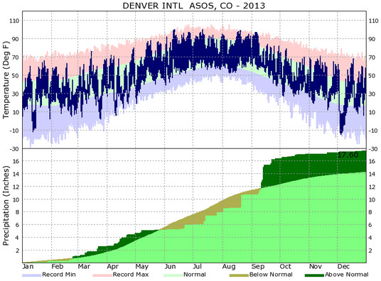
Another year is in the books and as we look back at 2013’s weather, we see Thornton – and indeed much of the state – saw cooler and wetter than normal conditions.
In terms of temperatures, Thornton saw an average overall annual temperature of 49.3 degrees. Out at Denver International Airport where the Mile High City’s official records are kept, the average was warmer at 50.1 degrees. By comparison, Denver’s 1981 to 2010 annual average temperature is 50.4 degrees.
Thornton recorded 47 days with temperatures at or above the 90 degree mark. At DIA 54 such days were recorded. Both were above the average of 40 90 degree days per year.
The hottest temperature recorded during the year in Thornton came on June 11th when the mercury climbed to 99.2 degrees. Denver’s hottest temperature of 100 degrees came on June 11th and July 11th.
At the opposite end of the thermometer, Thornton saw 175 days with low temperatures below freezing. Denver was very similar with 169 days with temperatures below 32 degrees. On average we expect to see 157 days below freezing.
Our coldest temperature in Thornton came last month on December 5th when the mercury dropped to -9.3 degrees. Denver’s occurred on the same date as the mercury at the airport dropped to -15 degrees.
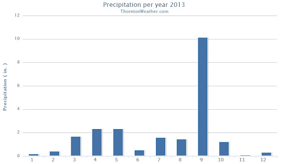
Precipitation for 2013 came in well above normal thanks largely in part to the extraordinary amount of rain received in September.
In all, Thornton saw 21.67 inches of liquid precipitation in our bucket. Denver, as always drier due to the station being at DIA, saw 17.60 inches. Both were above the annual average of 14.92 inches.
Above and by far the wettest month of the year was September and was responsible for the above average precipitation numbers. Thornton saw 10.15 inches in the rain bucket that month alone, Denver 5.61 inches.
Snowfall during the calendar year ended up relatively strong thanks to healthy totals from February through April. Overall the rest of the months of the year saw below normal snowfall.
Thornton’s annual snow total came in at an even 70.0 inches. Denver bested us with 74.1 inches during 2013.
Denver’s 2013 / 2014 season however has started out dismally with only 8.1 inches so far in the Mile High City. Thornton ended December a bit better with 10.8 inches. Both are well below the long term average that would have us see 21.2 inches by the end of the year.
Thornton, Colorado temperature summary chart for 2013.Thornton, Colorado precipitation summary for 2013.Denver, Colorado temperature and precipitation summary. (National Weather Service)
CLIMATE REPORT
NATIONAL WEATHER SERVICE BOULDER, CO
427 PM MST WED JAN 1 2014

...................................

...THE DENVER CO CLIMATE SUMMARY FOR THE YEAR OF 2013...

CLIMATE NORMAL PERIOD 1981 TO 2010
CLIMATE RECORD PERIOD 1872 TO 2013

WEATHER         OBSERVED          NORMAL  DEPART  LAST YEAR`S
                 VALUE   DATE(S)  VALUE   FROM    VALUE  DATE(S)
                                          NORMAL
................................................................
TEMPERATURE (F)
RECORD
 HIGH             105   06/26/2012
                        06/25/2012
                        07/20/2005
 LOW              -29   01/09/1875
HIGHEST           100   07/11        64      36      105  06/26
                        06/11                             06/25
LOWEST            -15   12/05        36     -51       -6  01/11
AVG. MAXIMUM     63.9              64.7    -0.8     68.4
AVG. MINIMUM     36.3              36.3     0.0     39.3
MEAN             50.1              50.5    -0.4     53.9
DAYS MAX >= 90     54              39.6    14.4       73
DAYS MAX <= 32     29              20.0     9.0       19
DAYS MIN <= 32    169             156.9    12.1      132
DAYS MIN <= 0      11               5.8     5.2        4

PRECIPITATION (INCHES)
RECORD
 MAXIMUM        23.31   1967
 MINIMUM         7.29   2008
TOTALS          17.60             14.30    3.30    10.11
DAILY AVG.       0.05              0.03    0.02     0.03
DAYS >= .01        82              79.7     2.3       52
DAYS >= .10        42              34.9     7.1       23
DAYS >= .50         8               7.6     0.4        9
DAYS >= 1.00        3               2.3     0.7        1
GREATEST
 24 HR. TOTAL    2.39   09/13 TO 09/14

 STORM TOTAL     4.65   09/09 TO 09/15

SNOWFALL (INCHES) RECORDS
TOTAL          115.9   1913
24 HR TOTAL     23.6   12/24/1982 TO 12/24/1982
SNOW DEPTH        MM   MM
TOTALS           72.1              53.8    18.3     38.5
 LIQUID EQUIV    5.40              5.40      MM     3.85
SINCE 7/1         8.1              22.5   -14.4     12.4
 LIQUID 7/1      0.81              2.20   -1.39     1.24
SNOWDEPTH AVG.      0                MM      MM        0
DAYS >= TRACE      60              33.3    26.7       36
DAYS >= 1.0        20              16.3     3.7       13
GREATEST
 SNOW DEPTH         9   02/25                         11  02/04
 24 HR TOTAL      9.1   02/24 TO 02/24              12.5  03/03
 STORM TOTAL     11.7   03/22 TO 03/24              15.9  03/02
                                                          03/04

DEGREE_DAYS
HEATING TOTAL    6302              6059     243     5198
 SINCE 7/1       2451              2468     -17     2233
COOLING TOTAL     999               769     230     1236
 SINCE 1/1        999               769     230     1236

FREEZE DATES
RECORD
 EARLIEST     09/08/1962
 LATEST       06/08/2007
EARLIEST                        10/07
LATEST                          05/05
..................................................

WIND (MPH)
AVERAGE WIND SPEED              9.7
RESULTANT WIND SPEED/DIRECTION   2/201
HIGHEST WIND SPEED/DIRECTION    64/060    DATE  06/18
HIGHEST GUST SPEED/DIRECTION    97/040    DATE  06/18

SKY COVER
POSSIBLE SUNSHINE (PERCENT)   MM
AVERAGE SKY COVER           0.60
NUMBER OF DAYS FAIR           69
NUMBER OF DAYS PC            232
NUMBER OF DAYS CLOUDY         64

AVERAGE RH (PERCENT)     52

WEATHER CONDITIONS. NUMBER OF DAYS WITH
THUNDERSTORM              0     MIXED PRECIP               0
HEAVY RAIN               14     RAIN                      25
LIGHT RAIN               80     FREEZING RAIN              0
LT FREEZING RAIN          4     HAIL                       0
HEAVY SNOW               11     SNOW                      23
LIGHT SNOW               58     SLEET                      0
FOG                     105     FOG W/VIS <= 1/4 MILE     33
HAZE                     88

-  INDICATES NEGATIVE NUMBERS.
R  INDICATES RECORD WAS SET OR TIED.
MM INDICATES DATA IS MISSING.
T  INDICATES TRACE AMOUNT.
As we begin the new year the winter chill begins to set in. While January can see its share of extremes, the month historically sees stable temperatures and is usually relatively dry.
January ranks as the second coldest month in Denver next to December with average temperatures remaining virtually the same from the start to the end of the month. In terms of snowfall, the month only ranks as the fourth snowiest and it is not uncommon for it to be quite dry.
What does January 2013 hold for us? Indications are that we may very well continue the recent pattern of below normal temperatures and relatively dry conditions.
The best photos of 2013 as seen through ThorntonWeather.com’s lenses. View the slideshow below.
Colorado’s weather and scenery can certainly be dramatic and the past year has been no different. Armed with our camera, we captured hundreds of images and shared them with our readers.
While we are entirely amateur photographers, sometimes Colorado makes it hard to take a bad picture. Over the course of 2013 we took hundreds of photos, many of which were shared with you on Facebook, Google+ and Twitter.
Picking which of the images we liked the best was not easy. The subject matter ranged from weather to wildlife to expansive landscapes and even heavenly bodies.
As we sorted through we couldn’t help but notice the lack of real weather drama in the photos we took. While there were wildfires to our south and floods to the north, Thornton managed to escape the year relatively unscathed from Mother Nature’s wrath.
We also were unable to do any real storm chasing so severe weather imagery was lacking. Hopefully that can be rectified in 2014. 😉
When all was said and done we came up with 25 images that we thought were our best photos of the year. You can view them in the slideshow below. Leave a comment here or on our social media pages and let us know what you think.
Remember too that we love seeing your photos so be sure to share them with us!
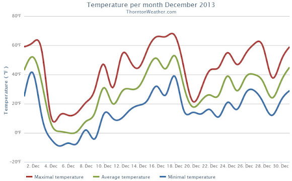
Thornton and the Denver area closed out 2013 with a display of typically highly variable weather. We recorded some record low temperatures followed by unseasonably warm conditions. One thing that was lacking was snow.
The first three days of the month started out quite mild with highs well above normal. That changed quickly midday on the third as low pressure moved in bringing an extended Arctic blast.
For six straight days high temperatures remained stubbornly below freezing and lows dipped into the single digits. The cold snap was notable but not record-setting in terms of length. Two daily low temperature records were tied or broken however.
Warmer weather returned on the 10th as the mercury finally started to climb. Unseasonably warm temperatures became the rule for the next nine days that included a record high temperature on the 18th.
The last third of the month was a bit more variable with its ups and downs but overall warmer than normal conditions.
Overall Thornton’s monthly average temperature came in at 29.2 degrees. Out at Denver International Airport where the Mile High City’s official stats are recorded, it was a bit cooler with an average of 28.4 degrees. Both were below Denver’s December average of 30.0 degrees.
Thornton recorded nine days with high temperatures that failed to reach 32 degrees. On five days, low temperatures dropped below zero. Denver saw eight days with highs below freezing, six with lows below zero.
The warmest temperature of the month in Thornton came on the 18th when we recorded 66.8 degrees. Our coldest was -9.3 degrees on the 5th. Denver’s warmest day was on the 18th as well with a high of 68 degrees. Its lowest temperature was -15 degrees on the 5th.
Four temperature records were tied or broken in Denver.
The low temperature of -13 degrees on December 4th shattered the old record low for the date of -5 degrees last set in 2008. The following day, on December 5th, the low temperature of -15 degrees tied the record low last set in 1972.
The mild weather December 18 saw two records. The high of 68 degrees broke the previous high temperature record for the date of 66 degrees last set in 1979. Also, the day tied the record high minimum for the 18th of 40 degrees set in 1917.
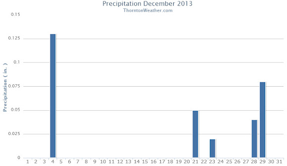
Precipitation for the month of December 2013 was not as noteworthy as the temperatures. Thornton recorded only 0.24 inches in our bucket while Denver received 0.25 inches. Both were a good bit below the December average of 0.35 inches.
Snow was similarly less than extraordinary. Thornton measured 5.7 inches of the white stuff while Denver lagged that with 4.7 inches. Both totals were below the normal for December of 8.5 inches. Seasonal snowfall totals at this point are about half of what they normally are.
Thornton’s December 2013 Temperatures.Thornton’s December 2013 Precipitation.
CLIMATE REPORT
NATIONAL WEATHER SERVICE BOULDER, CO
200 AM MST WED JAN 1 2014

...................................

...THE DENVER CO CLIMATE SUMMARY FOR THE YEAR OF 2013...

CLIMATE NORMAL PERIOD 1981 TO 2010
CLIMATE RECORD PERIOD 1872 TO 2013

WEATHER         OBSERVED          NORMAL  DEPART  LAST YEAR`S
                 VALUE   DATE(S)  VALUE   FROM    VALUE  DATE(S)
                                          NORMAL
................................................................
TEMPERATURE (F)
RECORD
 HIGH             105   06/26/2012
                        06/25/2012
                        07/20/2005
 LOW              -29   01/09/1875
HIGHEST           100   07/11        64      36      105  06/26
                        06/11                             06/25
LOWEST            -15   12/05        36     -51       -6  01/11
AVG. MAXIMUM     63.9              64.7    -0.8     68.4
AVG. MINIMUM     36.3              36.3     0.0     39.3
MEAN             50.1              50.5    -0.4     53.9
DAYS MAX >= 90     54              39.6    14.4       73
DAYS MAX <= 32     29              20.0     9.0       19
DAYS MIN <= 32    169             156.9    12.1      132
DAYS MIN <= 0      11               5.8     5.2        4
PRECIPITATION (INCHES)
RECORD
 MAXIMUM        23.31   1196
 MINIMUM         7.29   2008
TOTALS          17.60             14.30    3.30    10.11
DAILY AVG.       0.05              0.04    0.01     0.03
DAYS >= .01        82              79.7     2.3       52
DAYS >= .10        42              34.9     7.1       23
DAYS >= .50         8               7.6     0.4        9
DAYS >= 1.00        3               2.3     0.7        1
GREATEST
 24 HR. TOTAL    2.39   MM                       12/31 TO 12/31
                                                          12/31 TO 12/31
                                                          12/31 TO 12/31
 STORM TOTAL       MM                                 MM
 (MM/DD(HH))            MM                    12/31(00) TO 12/31(00)
                                                 12/31(00) TO 12/31(00)1
                                                 12/31(00) TO 12/31(00)1

SNOWFALL (INCHES)
RECORDS
 TOTAL             MM   5
 24 HR TOTAL       MM
 SNOW DEPTH        MM   MM
TOTALS           74.1              53.8    20.3     38.5
 LIQUID EQUIV    7.41              5.40    2.01     3.85
SINCE 7/1         8.1              22.5   -14.4     12.4
 LIQUID 7/1      0.81              2.20   -1.39     1.24
SNOWDEPTH AVG.      0                MM      MM        0
DAYS >= TRACE      60              33.3    26.7       36
DAYS >= 1.0        20              16.3     3.7       13
GREATEST
 SNOW DEPTH         9   02/25                         11  02/04
 24 HR TOTAL      9.1   MM                       12/31 TO 12/31
                                                          12/31 TO 12/31
                                                          12/31 TO 12/31
 STORM TOTAL       MM                                 MM
 (MM/DD(HH))            MM                    12/31(00) TO 12/31(00)
                                                 12/31(00) TO 12/31(00)1
                                                 12/31(00) TO 12/31(00)1

DEGREE_DAYS
HEATING TOTAL    6302              6059     243     5198
 SINCE 7/1         MM              2468      MM       MM
COOLING TOTAL     999                 0     999     1236
 SINCE 1/1        999               769     230     1236

FREEZE DATES
RECORD
 EARLIEST     09/08/1962
 LATEST       06/08/2007
EARLIEST                        10/07
LATEST                          05/05
..................................................

WIND (MPH)
AVERAGE WIND SPEED              9.7
RESULTANT WIND SPEED/DIRECTION   2/201
HIGHEST WIND SPEED/DIRECTION    64/060    DATE  06/18
HIGHEST GUST SPEED/DIRECTION    97/040    DATE  06/18

SKY COVER
POSSIBLE SUNSHINE (PERCENT)   MM
AVERAGE SKY COVER           0.60
NUMBER OF DAYS FAIR           69
NUMBER OF DAYS PC            232
NUMBER OF DAYS CLOUDY         64

AVERAGE RH (PERCENT)     52

WEATHER CONDITIONS. NUMBER OF DAYS WITH
THUNDERSTORM              0     MIXED PRECIP               0
HEAVY RAIN               14     RAIN                      25
LIGHT RAIN               80     FREEZING RAIN              0
LT FREEZING RAIN          4     HAIL                       0
HEAVY SNOW               11     SNOW                      23
LIGHT SNOW               58     SLEET                      0
FOG                     105     FOG W/VIS <= 1/4 MILE     33
HAZE                     88

-  INDICATES NEGATIVE NUMBERS.
R  INDICATES RECORD WAS SET OR TIED.
MM INDICATES DATA IS MISSING.
T  INDICATES TRACE AMOUNT.
Santa Claus begins his whirlwind trip around the globe tonight to deliver toys to all the good little boys and girls! For more than 50 years the North American Aerospace Defense Command (NORAD) has tracked Kris Kringle on Christmas Eve and helped to ensure he completes his journey safely.
ThorntonWeather.com is pleased to be able to provide live Santa tracking from NORAD right here on our site!
For many, the holiday season isn’t complete without a chill in the air and snow on the ground. Here in Denver we historically enjoy a better chance of experiencing the proverbial white Christmas than many places in the nation.
However, how the Mile High City fares in experiencing a white Christmas does depend on your definition of one.
If it means having actual snowfall on Christmas Day the chances aren’t that good. But, if simply having snow on the ground suffices, the chances improve considerably.
Colorado’s famously inconsistent weather appears to be on full display this month. Just two weeks ago we were setting records for cold. Today we broke a record high temperature and tied the record high minimum.
At 12:59 p.m. the temperature at Denver International Airport reached 68 degrees. This broke the old record high temperature for December 18 of 66 degrees last set in 1979.
Additionally, Denver’s low temperature was 40 degrees. This tied the record low maximum for the date set in 1917.
The average high for December 18 is 42 degrees and the average low is 17 degrees.
Here in Thornton we were just slightly cooler as the mercury here topped out at 67 degrees at 12:44 p.m. Our low dropped to 39 degrees.
 The stage is set for Thornton to receive its most significant snowfall of the season thus far. Up in the high country snowfall will be measured in feet.
 In a very brief period of time the forecast for the next 48 hours has changed considerably. The latest data indicates Thornton and the Colorado Front Range may be receiving a healthy dose of snow starting Thursday afternoon and lasting into Friday.
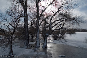
 Another year is in the books and as we look back at 2013’s weather, we see Thornton – and indeed much of the state – saw cooler and wetter than normal conditions.
 As we begin the new year the winter chill begins to set in. While January can see its share of extremes, the month historically sees stable temperatures and is usually relatively dry.
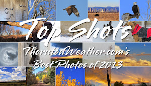

. NOAA / NCDC")
 Colorado’s famously inconsistent weather appears to be on full display this month. Just two weeks ago we were setting records for cold. Today we broke a record high temperature and tied the record high minimum.