Category Archives: Thornton Weather

September snowfall in Denver not so unusual

September snow in Denver?  Possible and not at all unusual.
September snow in Denver? Possible and not at all unusual.

With a significant blast of cold air set to arrive this week, there is a chance for the Mile High City to see its first snowfall of the season.  While such an event would be the first September snow of this millennium, it would hardly be unusual.

Looking back at Denver’s snowfall records dating to 1882, 45 Septembers have recorded a trace or more of snowfall.  That means that out of 132 Septembers including this one, roughly one third of them have seen snow. Overall, the month averages 1.1 inches.

Of those 45 Septembers with snow, 17 were for only a trace.  Twenty eight, or roughly 21 percent, had measurable snowfall of 0.1” or more.

Denver’s heaviest 24 hour September snowfall came between September 24 and 25 in 1936 when a hefty 15.0 inches fell to the ground.  That snowfall contributed to 1936 taking its place as the second snowiest September on record.

For the entire month of September, some years saw rather significant totals.  The top 10 September snowfall totals include:

17.2 inches in 1971
16.5 inches in 1936
12.9 inches in 1959
11.4 inches in 1895
8.7 inches in 1985
7.4 inches in 1995
6.5 inches in 1908
5.8 inches in 1961
5.5 inches in 1965
5.4 inches in 1993

The earliest snowfall on record occurred on September 3, 1961.  On that date 4 inches of snowfall fell at the old Stapleton International Airport and the mercury dropped to a low of 33 degrees.

The last time Denver saw a September snow was on September 23, 2000 when 0.2 inches was recorded.

On average, we receive our first snow on October 19 so should snow fall, it will be well ahead of normal.

The cold that looks to come could very well bring an end to the growing season.  The Mile High City’s first frost on average comes on September 20th followed by the average first freeze on October 7.  Given that, a frost at the current time of the month is not that far off the mark.  It does not appear at this moment we will see that first freeze – yet – but a frost is possible.

Will September 2014 break the 13 year streak with no September snow?  Standby and check our forecast for the latest.

Thornton’s September weather preview: Usually one of our more pleasant months

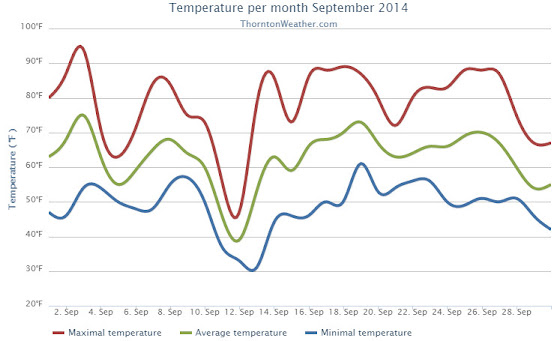
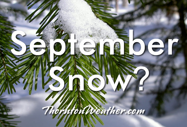
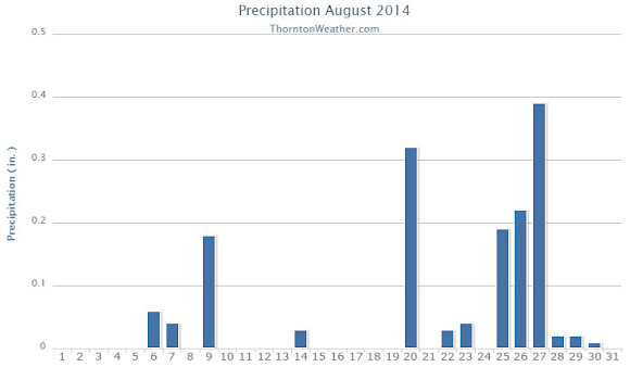
Following on a cooler and wetter than normal August, the month of September arrives and one can’t help but wonder if an early fall lies in wait as well.  The month can bring our first snow of the season but more often than not, it is one of the most pleasant along the Colorado Front Range.

As temperatures start to drop, September usually reminds us that summer is at an end and fall is now here. Sunshine is predominant though as the month actually has the highest percentage of sun out of any month. Sunny days and clear, cool nights are the standard weather pattern for the month.

The month can bring extremes however.  We will of course forever remember last year’s devastating floods brought on by record-setting rain.  Longtime residents might remember September 1971 which brought over 17 inches of snowfall.

Get a complete look at September’s weather and more details as to what we can expect this year here.

August 2014 weather recap: Thornton sees cooler than normal temps, near normal precip

Periods of monsoonal moisture contributed to rain and clouds in August 2014.  Coupled with the occasional cold front, the end result was a month that saw temperatures below normal and regular daily thunderstorms.

Thornton’s average temperature for the month came in at 68.2 degrees.  This was more than four degrees cooler than Denver’s long term August average of 72.5 degrees.  Out at Denver International Airport it was similarly cool with an average reading of 70.6 degrees.

Temperatures in Thornton ranged from a high of 94.4 degrees on the 17th down to a low of 47.6 degrees on the 30th.  Only six days saw readings of 90 degrees or higher.

Denver’s warmest reading of 91 degrees occurred on the 17th and again on the 19th.  Low readings of 52 degrees were seen on four days during the month.  Four 90 degree days were recorded at DIA.

In terms of precipitation, Thornton measured 1.55 inches in the rain bucket over the course of the month.  This was slightly below Denver’s August average of 1.69 inches.

The airport however fared better with 2.73 inches as many of the afternoon storms didn’t really get started until they were past Thornton.

Click here to view Thornton’s August 2014 climate report.

Thornton, Colorado's August 2014 Temperature Summary. (ThorntonWeather.com)
Thornton, Colorado’s August 2014 Temperature Summary. (ThorntonWeather.com)
Thornton, Colorado's August 2014 Precipitation Summary. (ThorntonWeather.com)
Thornton, Colorado’s August 2014 Precipitation Summary. (ThorntonWeather.com)
CLIMATE REPORT
NATIONAL WEATHER SERVICE BOULDER, CO
136 PM MDT MON SEP 1 2014

...................................

...THE DENVER CO CLIMATE SUMMARY FOR THE MONTH OF AUGUST 2014...

CLIMATE NORMAL PERIOD 1981 TO 2010
CLIMATE RECORD PERIOD 1872 TO 2014

WEATHER         OBSERVED          NORMAL  DEPART  LAST YEAR`S
                 VALUE   DATE(S)  VALUE   FROM    VALUE  DATE(S)
                                          NORMAL
................................................................
TEMPERATURE (F)
RECORD
 HIGH             105   08/08/1878
 LOW               40   08/26/1910
                        08/25/1910
                        08/24/1910
                        08/22/1904
HIGHEST            91   08/19       105     -14       99  08/20
                        08/17
LOWEST             52   08/31        40      12       52  08/09
                        08/30
                        08/25
                        08/24
AVG. MAXIMUM     83.8              87.2    -3.4     89.4
AVG. MINIMUM     57.4              57.9    -0.5     59.8
MEAN             70.6              72.5    -1.9     74.6
DAYS MAX >= 90      4              11.5    -7.5       16
DAYS MAX <= 32      0               0.0     0.0        0
DAYS MIN <= 32      0               0.0     0.0        0
DAYS MIN <= 0       0               0.0     0.0        0

PRECIPITATION (INCHES)
RECORD
 MAXIMUM         5.85   1979
 MINIMUM         0.02   1924
TOTALS           2.73              1.69    1.04     2.78
DAILY AVG.       0.09              0.05    0.04     0.09
DAYS >= .01        13               8.6     4.4        7
DAYS >= .10         5               4.3     0.7        2
DAYS >= .50         3               1.2     1.8        2
DAYS >= 1.00        0               0.3    -0.3        1
GREATEST
 24 HR. TOTAL    1.45   08/25 TO 08/26

SNOWFALL (INCHES)
RECORDS
 TOTAL            0.0
TOTALS            0.0               0.0

DEGREE_DAYS
HEATING TOTAL       2                10      -8        0
 SINCE 7/1          7                16      -9        0
COOLING TOTAL     182               244     -62      308
 SINCE 1/1        613               688     -75      866

FREEZE DATES
RECORD
 EARLIEST     09/08/1962
 LATEST       06/08/2007
EARLIEST                        10/07
LATEST                          05/05
..................................................

WIND (MPH)
AVERAGE WIND SPEED              8.9
RESULTANT WIND SPEED/DIRECTION   3/194
HIGHEST WIND SPEED/DIRECTION    48/320    DATE  08/25
HIGHEST GUST SPEED/DIRECTION    48/320    DATE  08/25

SKY COVER
POSSIBLE SUNSHINE (PERCENT)   MM
AVERAGE SKY COVER           0.50
NUMBER OF DAYS FAIR            5
NUMBER OF DAYS PC             24
NUMBER OF DAYS CLOUDY          2

AVERAGE RH (PERCENT)     53

WEATHER CONDITIONS. NUMBER OF DAYS WITH
THUNDERSTORM             14     MIXED PRECIP               0
HEAVY RAIN                5     RAIN                       4
LIGHT RAIN               17     FREEZING RAIN              0
LT FREEZING RAIN          0     HAIL                       1
HEAVY SNOW                0     SNOW                       0
LIGHT SNOW                0     SLEET                      0
FOG                       6     FOG W/VIS <= 1/4 MILE      0
HAZE                      1

-  INDICATES NEGATIVE NUMBERS.
R  INDICATES RECORD WAS SET OR TIED.
MM INDICATES DATA IS MISSING.
T  INDICATES TRACE AMOUNT.

August 2014 top shots: Monthly photo slideshow

August 7, 2014 - A butterfly enjoys blooming flowers in Thornton. (Bobby Hake)
August 7, 2014 – A butterfly enjoys blooming flowers in Thornton. (Bobby Hake)

August’s weather typically consists of warm daytime temperatures followed by afternoon and evening thunderstorms. Those storms provide excellent photo opportunities as do the various flora and fauna we see around this time of year.

Thornton’s spring and summer have been relatively wet allowing for a very lush, green landscape. Flowers are blooming and butterflies, bees and birds are all taking advantage of them. The near daily thunderstorms offer rain as well as lightning and sometimes hail. All make for prime photo subjects.

  • Slideshow updated August 31, 2014
  • To learn more about how to send your photo to us for inclusion in the slideshow, see below the slideshow.

Showcasing images captured by ThorntonWeather.com readers as well as some of our own, our monthly slideshow covers the entire gamut of weather-related imagery.

Sunsets, sunrises, wildlife and of course every type of weather condition are vividly depicted in images captured from yours and our cameras.

Click the play button below and sit back and enjoy the images.

What is missing in the slideshow above?  Your photo!

Our monthly photo slideshow is going to feature images that we have taken but more importantly images that you have captured.  The photos can be of anything even remotely weather-related.

Landscapes, current conditions, wildlife, pets, kids.  Whimsical, newsy, artsy.  Taken at the zoo, some other area attraction, a local park, a national park or your backyard.  You name it, we want to see and share it!

Images can be taken in Thornton, Denver or anywhere across the extraordinary Centennial State.  We’ll even take some from out of state if we can tie it to Colorado somehow.

We’ll keep the criteria very open to interpretation with just about any image eligible to be shown in our slideshows.

What do you win for having your image in our slideshow?  We are just a ‘mom and pop’ outfit and make no money from our site so we really don’t have the means to provide prizes.  However you will have our undying gratitude and the satisfaction that your images are shared on the most popular website in Thornton.

To share you images with us and get them included in the slideshow just email them to us or share them with ThorntonWeather.com on any of the various social media outlets.  Links are provided below.

So come on, get those camera’s rolling!

July 2014 weather recap: Thornton sees cooler, wetter than normal month

July 2014 will go into the history books as one of the wettest on record in the Mile High City.  A healthy monsoon flow also contributed to overall below normal temperatures.

The month started out cooler than normal but the third of the month brought a string of 90 plus degree days that lasted until the 11th of the month with only one day not reaching the mark during that time.

Cooler temperatures arrived for the next seven days with three of those seeing highs only in the 70s.  A healthy shot of moisture on the 11th turned lawns green.

We bounced right back to the 90s on the 19th but then saw the cool weather return on the 27th.  Light rain on the 28th was followed by heavy rain on the 29th and 30th pushing the month into the rain fall record books.

The 30th of the month was notable for a record setting low maximum temperature with a reading more like we would expect to see in April or October.

Thornton saw an overall average temperature for July 2014 of 71.5 degrees.  This is well below the Denver July average of 74.2 degrees.

As measured at Denver International Airport, the Mile High City’s official reading was warmer than ours with an average of 74.5.  The airport’s location further east allows it to hold off seeing the typical afternoon clouds for a bit longer than areas to the west and thus it typically sees warmer temperatures.

Our warmest temperature reading of the month was 98.2 degrees on the 7th.  Thornton recorded 16 days of 90 degree or warmer temperatures.  Conversely, our coldest reading was 54.1 degrees on the first of the month.

Denver’s maximum reading also occurred on the 7th but was warmer at 100 degrees.  The airport saw 17 days with reading of 90 degrees or higher.  The lowest reading of the month was 55 degrees on the 16th and 17th.

One temperature record was set during July.  On the 30th the maximum temperature only reached 62 degrees (Thornton recorded 62.2 degrees).  This broke the record low maximum for the date of 64 degrees set in 2009.

In terms of precipitation, there was plenty of it across the board.

Denver averages 2.16 inches during July.  In Thornton we recorded a healthy 4.69 inches while Denver officially saw 3.85 inches.

For both locations, nearly half of those totals came on the 29th and 30th.  The Denver total puts it into the books as one of the wettest Julys on record. Additionally, the Denver total on the 29th set a record for that date.

Click here to view Thornton’s July 2014 climate report.

Thornton, Colorado July 2014 Temperature Summary. (ThorntonWeather.com)
Thornton, Colorado July 2014 Precipitation Summary. (ThorntonWeather.com)
CLIMATE REPORT
NATIONAL WEATHER SERVICE BOULDER, CO
550 AM MDT FRI AUG 1 2014

...................................

...THE DENVER CO CLIMATE SUMMARY FOR THE MONTH OF JULY 2014...

CLIMATE NORMAL PERIOD 1981 TO 2010
CLIMATE RECORD PERIOD 1872 TO 2014

WEATHER         OBSERVED          NORMAL  DEPART  LAST YEAR`S
                 VALUE   DATE(S)  VALUE   FROM    VALUE  DATE(S)
                                          NORMAL
................................................................
TEMPERATURE (F)
RECORD
HIGH             105   07/20/2005
LOW               42   07/04/1903
                        07/31/1873
HIGHEST           100   07/07       105      -5      100  07/11
LOWEST             55   07/17        42      13       55  07/02
                        07/16
AVG. MAXIMUM     88.3              89.4    -1.1     88.2
AVG. MINIMUM     60.6              58.9     1.7     60.4
MEAN             74.5              74.2     0.3     74.3
DAYS MAX >= 90     17              16.0     1.0       17
DAYS MAX <= 32      0               0.0     0.0        0
DAYS MIN <= 32      0               0.0     0.0        0
DAYS MIN <= 0       0               0.0     0.0        0

PRECIPITATION (INCHES)
RECORD
MAXIMUM         6.41   1965
MINIMUM         0.01   1901
TOTALS           3.85              2.16    1.69     1.98
DAILY AVG.       0.12              0.07    0.05     0.06
DAYS >= .01         8               8.3    -0.3        7
DAYS >= .10         6               4.3     1.7        4
DAYS >= .50         2               1.4     0.6        2
DAYS >= 1.00        2               0.7     1.3        0
GREATEST
24 HR. TOTAL    2.85   07/29 TO 07/30

SNOWFALL (INCHES)
RECORDS
TOTAL            0.0
TOTALS            0.0               0.0

DEGREE_DAYS
HEATING TOTAL       5                 6      -1        0
SINCE 7/1          5                 6      -1        0
COOLING TOTAL     304               289      15      295
SINCE 1/1        431               444     -13      558

FREEZE DATES
RECORD
EARLIEST     09/08/1962
LATEST       06/08/2007
EARLIEST                        10/07
LATEST                          05/05
......................................................

WIND (MPH)
AVERAGE WIND SPEED              9.7
RESULTANT WIND SPEED/DIRECTION   3/193
HIGHEST WIND SPEED/DIRECTION    51/310    DATE  07/11
HIGHEST GUST SPEED/DIRECTION    51/290    DATE  07/11

SKY COVER
POSSIBLE SUNSHINE (PERCENT)   MM
AVERAGE SKY COVER           0.60
NUMBER OF DAYS FAIR            4
NUMBER OF DAYS PC             24
NUMBER OF DAYS CLOUDY          3

AVERAGE RH (PERCENT)     51

WEATHER CONDITIONS. NUMBER OF DAYS WITH
THUNDERSTORM              0     MIXED PRECIP               0
HEAVY RAIN                2     RAIN                       7
LIGHT RAIN               13     FREEZING RAIN              0
LT FREEZING RAIN          0     HAIL                       0
HEAVY SNOW                0     SNOW                       0
LIGHT SNOW                0     SLEET                      0
FOG                       8     FOG W/VIS <= 1/4 MILE      1
HAZE                      7

-  INDICATES NEGATIVE NUMBERS.
R  INDICATES RECORD WAS SET OR TIED.
MM INDICATES DATA IS MISSING.
T  INDICATES TRACE AMOUNT.

July 2014 top shots: Monthly photo slideshow

July 3, 2014 - A gorgeous July sunset. (LE Worley)
July 3, 2014 – A gorgeous July sunset. (LE Worley)

The month of July typically brings a pretty tried and true daily weather pattern with hot days and afternoon thunderstorms.  Like any month of the year in Colorado, a wide variety of subjects will be presented for photo opportunities.

Flowers are now in full bloom, wildlife is abundant with many creatures showing their young for the first time, and then of course there is the weather.  Scorching heat, damaging thunderstorms, heavy rains and more are all possible during the month.

  • Slideshow updated July 31, 2014
  • To learn more about how to send your photo to us for inclusion in the slideshow, see below the slideshow.

Showcasing images captured by ThorntonWeather.com readers as well as some of our own, our monthly slideshow covers the entire gamut of weather-related imagery.

Sunsets, sunrises, wildlife and of course every type of weather condition are vividly depicted in images captured from yours and our cameras.

Click the play button below and sit back and enjoy the images.

What is missing in the slideshow above?  Your photo!

Our monthly photo slideshow is going to feature images that we have taken but more importantly images that you have captured.  The photos can be of anything even remotely weather-related.

Landscapes, current conditions, wildlife, pets, kids.  Whimsical, newsy, artsy.  Taken at the zoo, some other area attraction, a local park, a national park or your backyard.  You name it, we want to see and share it!

Images can be taken in Thornton, Denver or anywhere across the extraordinary Centennial State.  We’ll even take some from out of state if we can tie it to Colorado somehow.

We’ll keep the criteria very open to interpretation with just about any image eligible to be shown in our slideshows.

What do you win for having your image in our slideshow?  We are just a ‘mom and pop’ outfit and make no money from our site so we really don’t have the means to provide prizes.  However you will have our undying gratitude and the satisfaction that your images are shared on the most popular website in Thornton.

To share you images with us and get them included in the slideshow just email them to us or share them with ThorntonWeather.com on any of the various social media outlets.  Links are provided below.

So come on, get those camera’s rolling!

Record low maximum temperature set for July 30

July 31, 2014 - Sunrise snow on Mount Evans. (DU Observatory)
July 31, 2014 – Sunrise snow on Mount Evans. (DU Observatory)

With monsoonal moisture streaming into the state and cool air coming in from the north, Denver set its second weather record in as many days.

Denver’s official high temperature yesterday, July 30, as measured at DIA topped out at 62 degrees.  This sets a new record low maximum for the date easily besting the previous mark of 64 degrees set in 2009.

The reading is more akin to what we expect to see in April and October and well below the average high temperature for the date of 90 degrees.

Here in Thornton we matched that reading with 62 degrees as well.

Ironically, Al Gore’s Climate Reality Project was in Denver the past two days for EPA hearings. The group pushed the theme “I’m too hot” while serving up ice cream from Ben & Jerry’s.  Similar hearings were held in Washington DC and Atlanta and both cities saw below normal temperatures.

Perhaps not quite too hot, eh?  It would appear the “Gore Effect” has proven itself again.

On Tuesday Denver set a daily rainfall record as 1.80 inches fell in the bucket that day.

Thornton’s two-day rainfall total came in at 2.03 inches, nearly as much as Denver averages for the entire month of July.

Denver sets daily rainfall record for July 29

Record RainLate afternoon thunderstorms and showers began falling yesterday and continued through midnight.  Areas to the east and north, including Denver International Airport, saw more precipitation than other locations and DIA set a daily rainfall record as a result.

Denver’s official rainfall total for July 29 came in at a healthy 1.80 inches.  The previous 24 hour precipitation record for the date was 1.44 inches back in 1989.  Precipitation records in Denver began in 1872.

Here in Thornton we recorded 0.82 inches for the date.  While well short of Denver’s number, that is still a great deal of rain.

  • Stay up to date with the dynamic weather: Be sure to ‘like’ us on Facebook, follow us on Twitter and add us to your Google+ circles.

Two tornadoes touch down in north Denver metro area, minor damage seen

July 28, 2014 - Image of the tornado at the Rocky Mountain Arsenal. (Ed Dalton)  Click for a larger view.
July 28, 2014 – Image of the tornado at the Rocky Mountain Arsenal. (Ed Dalton) Click for a larger view.

Monday’s forecast called for a chance for thunderstorms but Mother Nature threw in a couple of wildcards in the form of two tornadoes in the area.  The landspout tornadoes caused minor damage in north Denver and were widely seen across much of the area.

The first tornado was reported at 3:53pm just across the Adams County line in Weld County near Fort Lupton.  The twister was the better defined of the two but appears to have struck farmland with no damage reported.

At 4:09pm a second tornado was reported near the Rocky Mountain Arsenal National Wildlife Refuge in Adams County.  A diesel repair shop near 51st and Havana had one of its garage doors ripped off and some material thrown about.

Denver International Airport sent travelers to shelters for a period of time and warning sirens were sounded in Brighton, Commerce City and other nearby locations.

Three people on a small boat on Barr Lake were overturned by the strong thunderstorm winds.  The trio managed to swim to shore and were not injured.

Tuesday’s weather is not expected to contain quite as much excitement as yesterday’s.  However, heavy rain will be possible and a Flash Flood Watch has been issued.

June 2014 weather recap: Slightly cooler, drier than normal conditions for the month

All-in-all, while temperatures and precipitation rain a bit lower than average, June 2014’s weather was pretty close to what we typically expect to see.  Thunderstorms made their appearances as always but we were spared much in the way of severe weather.

A series of fronts and troughs moved through northern Colorado during the month.  This helped to keep temperatures down and provided thunderstorms with a bit of regularity.

  • June 2014 top shots: Monthly photo slideshow
  • Thornton’s average temperature for the month came in at 66.5 degrees.  This is less than one degree below Denver’s historical June average of 67.4 degrees.  The Mile High City’s average came in slightly warmer at 67.3 degrees.

    Temperatures in Thornton ranged from a high of 92.1 degrees on June 3rd down to a low of 38.2 degrees on the morning of the 9th.  Denver was warmer on both measurements with a maximum reading of 94 degrees on the 26th and a low of 42 degrees on the 15th.

    Six days saw temperatures top the 90 degree mark in Thornton and Denver.  This is below the historical average of 7.9 days of 90 degree or warmer readings we expect to see.

    No temperature records were set during the month.

    In terms of precipitation, Thornton had 1.59 inches fall into our rain bucket.  Denver was a bit wetter with 1.82 inches.  Both fell below the June average of 1.98 inches.  Thornton saw eight days with measurable precipitation, Denver nine.

    Denver set a daily precipitation record of 0.51 inches on the 27th.  This bested the old record for that date of 0.29 inches in 1949.  Thornton recorded 0.60 inches on the same day.

    Click here to view Thornton’s June 2014 climate report.

    Thornton, Colorado temperature summary for June 2014.
    Thornton, Colorado temperature summary for June 2014.
    Thornton, Colorado precipitation summary for June 2014.
    Thornton, Colorado precipitation summary for June 2014.
    ...THE DENVER CO CLIMATE SUMMARY FOR THE MONTH OF JUNE 2014...
    
    CLIMATE NORMAL PERIOD 1981 TO 2010
    CLIMATE RECORD PERIOD 1872 TO 2014
    
    WEATHER         OBSERVED          NORMAL  DEPART  LAST YEAR`S
                     VALUE   DATE(S)  VALUE   FROM    VALUE  DATE(S)
                                              NORMAL
    ................................................................
    TEMPERATURE (F)
    RECORD
     HIGH             105   06/26/2012
                            06/25/2012
                            54/01/2206
     LOW               30   06/02/1951
    HIGHEST            94   06/26
    LOWEST             42   06/15
    AVG. MAXIMUM     83.4              82.4     1.0     87.8
    AVG. MINIMUM     51.2              52.3    -1.1     54.3
    MEAN             67.3              67.4    -0.1     71.1
    DAYS MAX >= 90      6               7.9    -1.9       14
    DAYS MAX <= 32      0               0.0     0.0        0
    DAYS MIN <= 32      0               0.0     0.0        0
    DAYS MIN <= 0       0               0.0     0.0        0
    
    PRECIPITATION (INCHES)
    RECORD
     MAXIMUM         4.96   1882
     MINIMUM            T   1890
    TOTALS           1.82              1.98   -0.16     0.75
    DAILY AVG.       0.06              0.07   -0.01     0.03
    DAYS >= .01         9               8.4     0.6        4
    DAYS >= .10         5               4.6     0.4        2
    DAYS >= .50         1               1.4    -0.4        1
    DAYS >= 1.00        0               0.3    -0.3        0
    GREATEST
     24 HR. TOTAL    0.51   06/27 TO 06/27           06/23 TO 06/23
                            06/26 TO 06/27                    06/22 TO 06/23
                            06/27 TO 06/27                    06/23 TO 06/23
     STORM TOTAL       MM                                 MM
     (MM/DD(HH))            MM                    06/23(00) TO 06/23(00)
                                                     06/23(00) TO 06/23(00)3
                                                     06/23(00) TO 06/23(00)3
    
    SNOWFALL (INCHES)
    RECORDS
     TOTAL             MM   MM
    TOTALS            0.0               0.0
    
    DEGREE_DAYS
    HEATING TOTAL      30                62     -32       29
     SINCE 7/1       6004              6058     -54     6084
    COOLING TOTAL     106               133     -27      221
     SINCE 1/1        127               155     -28      263
    
    FREEZE DATES
    RECORD
     EARLIEST     09/08/1962
     LATEST       06/08/2007
    EARLIEST      10/04             10/07
    LATEST        05/14             05/05
    ....................................................
    
    WIND (MPH)
    AVERAGE WIND SPEED              10.5
    RESULTANT WIND SPEED/DIRECTION   3/148
    HIGHEST WIND SPEED/DIRECTION    39/300    DATE  06/18
    HIGHEST GUST SPEED/DIRECTION    55/220    DATE  06/18
    
    SKY COVER
    POSSIBLE SUNSHINE (PERCENT)   MM
    AVERAGE SKY COVER           0.50
    NUMBER OF DAYS FAIR            8
    NUMBER OF DAYS PC             21
    NUMBER OF DAYS CLOUDY          1
    
    AVERAGE RH (PERCENT)     53
    
    WEATHER CONDITIONS. NUMBER OF DAYS WITH
    THUNDERSTORM              0     MIXED PRECIP               0
    HEAVY RAIN                3     RAIN                       3
    LIGHT RAIN               12     FREEZING RAIN              0
    LT FREEZING RAIN          0     HAIL                       3
    HEAVY SNOW                0     SNOW                       0
    LIGHT SNOW                0     SLEET                      0
    FOG                       7     FOG W/VIS <= 1/4 MILE      4
    HAZE                      4
    
    -  INDICATES NEGATIVE NUMBERS.
    R  INDICATES RECORD WAS SET OR TIED.
    MM INDICATES DATA IS MISSING.
    T  INDICATES TRACE AMOUNT.