Wildlife is still quite active along the Front Range and flowers will hold on to their petals for at least the first part of the month. Then of course there is the weather which you never know what to expect. Thunderstorms, heavy rain, and even snow are a possibility.
Slideshow updated October 4, 2016
To learn more about how to send your photo to us for inclusion in the slideshow, see below the slideshow.
Showcasing images captured by ThorntonWeather.com readers as well as some of our own, our monthly slideshow covers the entire gamut of weather-related imagery.
Sunsets, sunrises, wildlife and of course every type of weather condition are vividly depicted in images captured from yours and our cameras.
[flickr_set id=”72157670754216514″]
What is missing in the slideshow above? Your photo!
Our monthly photo slideshow is going to feature images that we have taken but more importantly images that you have captured. The photos can be of anything even remotely weather-related.
Landscapes, current conditions, wildlife, pets, kids. Whimsical, newsy, artsy. Taken at the zoo, some other area attraction, a local park, a national park or your backyard. You name it, we want to see and share it!
Images can be taken in Thornton, Denver or anywhere across the extraordinary Centennial State. We’ll even take some from out of state if we can tie it to Colorado somehow.
We’ll keep the criteria very open to interpretation with just about any image eligible to be shown in our slideshows.
What do you win for having your image in our slideshow? We are just a ‘mom and pop’ outfit and make no money from our site so we really don’t have the means to provide prizes. However you will have our undying gratitude and the satisfaction that your images are shared on the most popular website in Thornton.
To share you images with us and get them included in the slideshow just email them to us or share them with ThorntonWeather.com on any of the various social media outlets. Links are provided below.
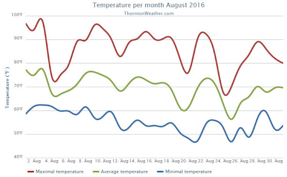
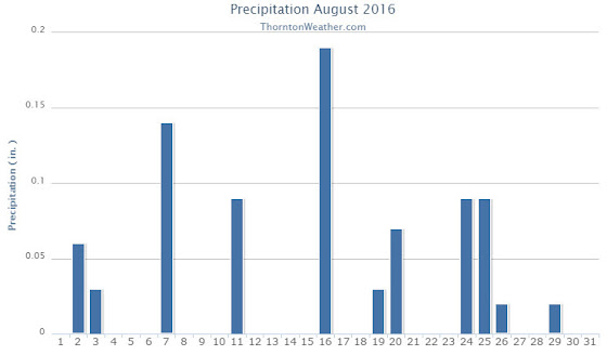
Our August weather was a bit of a mixed bag by the two biggest standards. On one hand, it was cooler than normal which was nice. On the other, we saw less than half the amount of precipitation we normally see during August.
August typically is when the monsoon kicks in and we see healthy doses of precipitation. This year however, the monsoonal flow was regularly disrupted by troughs digging in from the north and west.
August 2016 top shots: Monthly photo slideshow
We certainly started the month hot with three days of temperatures near or above 95 degrees. Things then cooled down for a few days as the first trough moved through. Warmer temperatures then returned with readings not too far off of normal for the next two weeks. The final 10 days or so of the month then saw cooler conditions with the majority of days recording readings below normal.
Thornton’s overall average temperature for the month came in at 69.5 degrees. That was three degrees cooler than Denver’s long term average of 72.5 degrees. Out at the airport where Denver’s official measurements are taken, the airport split the difference with an average of 71.2 degrees.
Temperature ranged from a high of 97.2 degrees on the third of the month down to a cool 46.7 degrees on the 25th. Denver saw a maximum of 97 degrees on the 9th and a low of 47 degrees on the 25th. Thornton saw 14 days with highs at or above 90 degrees while Denver recorded 15.
Officially, one temperature record was made. On the morning of the 27th the mercury at DIA dropped to 48 degrees typing the record low for the date.
In terms of precipitation, Denver averages 1.69 inches during the month of August. Thornton saw only 0.76 inches in our rain bucket. The airport fared even worse with only 0.22 inches making the month the eight driest August on record in Denver.
Thornton, Colorado’s August 2016 temperature summary. (ThorntonWeather.com)Thornton, Colorado’s August 2016 precipitation summary. (ThorntonWeather.com)
From the National Weather Service:
CLIMATE REPORT
NATIONAL WEATHER SERVICE DENVER/BOULDER CO
848 AM MDT THU SEP 1 2016

...................................

...THE DENVER CO CLIMATE SUMMARY FOR THE MONTH OF AUGUST 2016...

CLIMATE NORMAL PERIOD 1981 TO 2010
CLIMATE RECORD PERIOD 1872 TO 2016

WEATHER         OBSERVED          NORMAL  DEPART  LAST YEAR`S
                 VALUE   DATE(S)  VALUE   FROM    VALUE  DATE(S)
                                          NORMAL
................................................................
TEMPERATURE (F)
RECORD
 HIGH             105   08/08/1878
 LOW               40   08/26/1910
                        08/25/1910
                        08/24/1910
HIGHEST            97   08/09                         98  08/15
LOWEST             47   08/25                         43  08/23
                        08/20
AVG. MAXIMUM     86.3              87.2    -0.9     89.8
AVG. MINIMUM     56.2              57.9    -1.7     58.3
MEAN             71.2              72.5    -1.3     74.0
DAYS MAX >= 90     15              11.5     3.5       19
DAYS MAX <= 32      0               0.0     0.0        0
DAYS MIN <= 32      0               0.0     0.0        0
DAYS MIN <= 0       0               0.0     0.0        0

PRECIPITATION (INCHES)
RECORD
 MAXIMUM         5.85   1979
 MINIMUM         0.02   1924
TOTALS           0.22              1.69   -1.47     1.18
DAILY AVG.       0.01              0.05   -0.04     0.04
DAYS >= .01         4               8.6    -4.6        9
DAYS >= .10         1               4.3    -3.3        4
DAYS >= .50         0               1.2    -1.2        1
DAYS >= 1.00        0               0.3    -0.3        0
GREATEST
 24 HR. TOTAL    0.12   08/24 TO 08/24           08/11 TO 08/11
                                                          08/10 TO 08/11

DEGREE_DAYS
HEATING TOTAL      15                10       5       13
 SINCE 7/1         15                16      -1       18
COOLING TOTAL     218               244     -26      304
 SINCE 1/1        762               688      74      713

FREEZE DATES
RECORD
 EARLIEST     09/08/1962
 LATEST       06/08/2007
EARLIEST                        10/07
LATEST                          05/05
..................................................

WIND (MPH)
AVERAGE WIND SPEED              9.9
RESULTANT WIND SPEED/DIRECTION   2/173
HIGHEST WIND SPEED/DIRECTION    43/010    DATE  08/19
HIGHEST GUST SPEED/DIRECTION    55/020    DATE  08/19

SKY COVER
POSSIBLE SUNSHINE (PERCENT)   MM
AVERAGE SKY COVER           0.60
NUMBER OF DAYS FAIR            4
NUMBER OF DAYS PC             22
NUMBER OF DAYS CLOUDY          5

AVERAGE RH (PERCENT)     47

WEATHER CONDITIONS. NUMBER OF DAYS WITH
THUNDERSTORM             11     MIXED PRECIP               0
HEAVY RAIN                0     RAIN                       1
LIGHT RAIN               10     FREEZING RAIN              0
LT FREEZING RAIN          0     HAIL                       0
HEAVY SNOW                0     SNOW                       0
LIGHT SNOW                0     SLEET                      0
FOG                       5     FOG W/VIS <= 1/4 MILE      3
HAZE                      4

-  INDICATES NEGATIVE NUMBERS.
R  INDICATES RECORD WAS SET OR TIED.
MM INDICATES DATA IS MISSING.
T  INDICATES TRACE AMOUNT.
Following on what was a cool but dry August, some are certainly hoping for a bit of precipitation. The month can bring plenty of rain and even our first snow of the season but more often than not, it is one of the most pleasant along the Colorado Front Range.
As temperatures start to drop, September usually reminds us that summer is at an end and fall is now here. Sunshine is predominant though as the month actually has the highest percentage of sun out of any month. Sunny days and clear, cool nights are the standard weather pattern for the month.
The month can bring extremes however. We will of course forever remember last year’s devastating floods brought on by record-setting rain. Longtime residents might remember September 1971 which brought over 17 inches of snowfall.
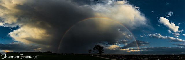
August 11, 2016 – An evening thunderstorm brings a gorgeous rainbow. (Shannon Dizmang)
As the calendar turns to August, the summertime heat begins to fade and that makes it easier to get out and enjoy all of the outdoor activities Colorado has to offer. From a walk in a park to afternoon thunderstorms to an abundance of wildlife, photo opportunities abound as is seen in our slideshow.
Our monsoon season typically arrives about now and that means better chances for moisture. However with limited instability, the intensity of storms are more sedate. That doesn’t mean however that the weather is any less photographic.
Slideshow updated August 31, 2016
By the end of the month some of our seasonal feathered friends will be looking to leave the state giving our last chance to see them till spring. Larger mammals are gearing up for the rut (mating season) and that can make for some intense scenes.
Showcasing images captured by ThorntonWeather.com readers as well as some of our own, our monthly slideshow covers the entire gamut of weather and nature related imagery. Sunsets, sunrises, wildlife and of course every type of weather condition are vividly depicted.
To learn more about how to send your photo to us for inclusion in the slideshow, see below the slideshow.
[flickr_set id=”72157669403542203″]
What is missing in the slideshow above? Your photo!
Our monthly photo slideshow is going to feature images that we have taken but more importantly images that you have captured. The photos can be of anything even remotely weather-related.
Landscapes, current conditions, wildlife, pets, kids. Whimsical, newsy, artsy. Taken at the zoo, some other area attraction, a local park, a national park or your backyard. You name it, we want to see and share it!
Images can be taken in Thornton, Denver or anywhere across the extraordinary Centennial State. We’ll even take some from out of state if we can tie it to Colorado somehow.
We’ll keep the criteria very open to interpretation with just about any image eligible to be shown in our slideshows.
What do you win for having your image in our slideshow? We are just a ‘mom and pop’ outfit and make no money from our site so we really don’t have the means to provide prizes. However you will have our undying gratitude and the satisfaction that your images are shared on the most popular website in Thornton.
To share you images with us and get them included in the slideshow just email them to us or share them with ThorntonWeather.com on any of the various social media outlets. Links are provided below.
August 14 to August 20: This week in Denver weather history
Severe weather is a fact of life in Colorado during the summer months and while August is historically relatively calm, that isn’t always the case. In our look back at this week in Denver weather history we see the dangers of lightning, incidents of large hail and flooding rains and even a tornado.
From the National Weather Service:
14
In 1960…a bolt of lightning struck a man in Henderson… Causing serious burns.
In 1962…the temperature climbed to a high of 100 degrees at Stapleton Airport.
In 1968…a young man on a golf course in Denver was injured when lightning struck a tree under which he was standing. Lightning caused minor damage to a house in Denver. Heavy thunderstorm rain caused local street flooding. One inch diameter hail fell at Jefferson County Airport near Broomfield.
In 1973…winds as high as 85 mph damaged 20 aircraft at the Arapahoe County airport…now centennial airport.
In 1977…three tornadoes were sighted in Bennett. A man suffered a broken leg when hit by a flying board. He was outside his camper home…which was destroyed. All windows were broken in a near-by farmhouse where some shingles were ripped off and a 2 car garage was knocked down. Several vehicles were damaged and a cat…some rabbits…and chickens were killed. A broken oar from a boat was driven into the side of a house. A mobile home was overturned. One old barn was destroyed. Half a dozen homes and several agricultural buildings were damaged just west of State Highway 79.
In 1978…high winds produced much blowing dust…causing many traffic accidents in the Denver-Boulder area. Winds gusts of 70 to 101 mph were recorded. Northwest winds gusted to 44 mph at Stapleton International Airport.
In 1980…lightning hit two power poles in Littleton…causing 400 dollars in damage. Rainfall of 1.23 inches in a short time caused minor flooding…which included damage to a ground floor apartment and partially submerging a few vehicles in water. Thunderstorm rainfall totaled 0.98 inch at Stapleton International Airport.
In 1983…2.10 inches of rain drenched Golden in an hour with similar amounts in Lakewood and Boulder. Over ten thousand dollars worth of plants were washed away at a nursery in Lakewood.
In 1997…twelve motorists were injured in a multi-car accident when strong microburst winds estimated to 50 mph blew blinding dust across I-70 near Bennett.
In 1998…lightning struck a hydro-electric plant in Nederland… Causing a power outage. Residents in the foothills west of Boulder…including Nederland…Ward…Eldora…Jamestown… And Gold Hill…were without power for about an hour.
In 2006…heavy thunderstorm rainfall near Deckers washed away some the banks along State Highway 67 between Deckers and Westcreek. Several driveways on both sides of the highway were also damaged.
15
In 1899…a thunderstorm produced southwest sustained winds to 43 mph with gusts to 46 mph.
In 1972…a pilot reported a funnel cloud briefly touching the ground in open fields…17 miles east-northeast of Stapleton International Airport.
In 1980…thunderstorm winds gusted to 55 mph in Boulder.
In 1982…brief heavy rain and winds estimated as high as 70 mph occurred in the conifer-Evergreen area. No damage was reported.
In 1990…lightning triggered a small attic fire in a house near Sedalia…20 miles south of Denver. A furious lightning storm caused widespread power outages across southern sections of metro Denver. One lightning bolt knocked out an electrical substation…causing a 90-minute blackout in southeast Denver affecting nearly 10 thousand homes and businesses.
In 2007…severe thunderstorms produced large hail…up to 2 inches in diameter…near larkspur. Extensive damage to vehicles in the area was reported.
In Parker…lightning struck a residence. The ensuing fire damaged the attic and top floor; causing $100000 in property damage.
In 2008…at least three homes were hit by lightning during the early morning hours in Arapahoe County. Lightning also struck two homes in Castle Rock…damaging the roofs.
16
In 1902…a thunderstorm produced west winds sustained to 48 mph with gusts to 60 mph…but only a trace of rain.
In 1952…a thunderstorm wind gust to 50 mph was recorded at Stapleton Airport.
In 1960…lightning struck a warehouse in central Denver… Causing 8 thousand dollars in damage to the building and stored electrical equipment.
In 1975…large hail…1 1/2 to 1 3/4 inches in diameter…fell about 4 miles north of Castle Rock. Hail caused some minor damage in Aurora. A funnel cloud was reported 25 miles east of Denver near Bennett.
In 1981…a tornado touched down briefly in open country just to the east of Aurora. No damage was reported.
In 1982…a thunderstorm wind gust to 61 mph was recorded at Buckley Field in Aurora. At the same time almost an inch of rain flooded and closed streets in south Aurora. A women was hit by lightning just north of Denver. A house in the area was also struck.
In 1985…a thunderstorm produced strong wind gusts over southern metro Denver. One strong wind gust hit Cheery Creek Reservoir…capsizing a boat and drowning a man. The wind gusts…clocked as high as 50 mph…also downed a few trees.
In 1989…1 3/4 inch diameter hail fell at Intercanyon in the foothills of Jefferson County.
In 1990…lightning caused minor damage to a south Aurora home. No injuries were reported.
In 1994…strong thunderstorm winds caused damage in southern weld County near Hudson and Fort Lupton. Two mobile homes were destroyed and a few lost their roofs. Up to 20 downed power poles and the destruction of two 115 thousand-volt towers caused widespread power outages. Thunderstorm gust front winds from the north gusted to 48 mph at Stapleton International Airport.
In 2000…lightning ripped most of the roof from a home in southeast Aurora. The bolt sparked a fire which destroyed the residence. Damage was estimated at 250 thousand dollars.
In 2002…the temperature climbed to a maximum of 100 degrees setting a new record high for the date.
In 2003…a teenager was injured when he was struck by lightning while camping at Herman Lake…13 miles northwest of Georgetown. The boy was knocked unconscious and suffered minor injuries.
In 2013…a dry microburst uprooted 30 to 40 large trees across a 12-block area of the Park Hill neighborhood in east central Denver. Several trees were snapped near the base along with numerous branches…8 to 10 inches in diameter. Power poles and lines were also downed with resulted in outages which affected seven hundred residents. One of the downed trees crushed a car`s hood… narrowly missing the driver. At Denver International Airport…a peak wind gust of 22 mph was observed from the southwest.
16-19
In 1979…heavy thunderstorm rains on each of 4 consecutive days dumped a total of 2.62 inches of rain on Stapleton International Airport. The heaviest rain…1.05 inches… On the 19th was accompanied by 1/4 inch diameter hail.
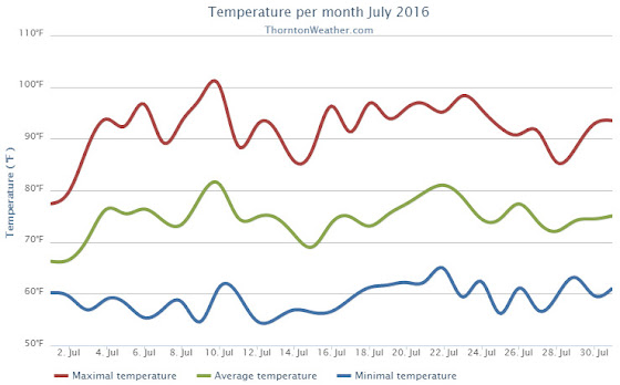
While the month of July seemed hot and dry, statistics show that only one of those two conditions held true. We definitely saw a big time lack of precipitation but temperatures averaged out to near normal.
High pressure was the dominate feature for the month leading to overall dry conditions. We started out cooler than normal and somewhat wet for the first two days of the month. That however changed quickly.
From the 3rd through the 17th of the month, Thornton saw temperatures largely remain above normal. Only two days during that period saw precipitation and both were minimal amounts. We saw our hottest temperature of the year to date and our only 100-degree temperature reading of the year on the 10th when the mercury topped out at 100.4 Degrees.
On the 14th and 15th of the month, we had a brief respite from the heat as temperatures were a bit below normal. However, we then put together a string of 12 straight days of 90 degree or hotter readings.
The 28th and 29th then broke the streak with temperatures in the mid to upper 80s. The month then closed with two days of above normal readings.
Thornton’s overall average temperature for the month came in at 74.7 degrees. This is just above the long term Denver average for July of 74.2 degrees. Out at DIA where the Mile High City’s official measurements are taken, the average for this July was much higher at 76.2 degrees.
Temperatures in Thornton ranged from the aforementioned 100.4 degrees on the 10th down to a low of 54.6 degrees on the morning of the 9th. Denver’s official high for the month was 102 degrees on the 10th and its low of 51 degrees came on the 12th.
In terms of precipitation, Denver averages 2.16 inches during the July. Thornton fell far short of that with a paltry 0.55 inches of rain in our bucket. The airport, while receiving nearly double our total at 1.09 inches, was well short of average as well.
Thornton, Colorado’s July 2016 temperature summary. (ThorntonWeather.com)Thornton, Colorado’s July 2016 precipitation summary. (ThorntonWeather.com)
From the National Weather Service:
CLIMATE REPORT
NATIONAL WEATHER SERVICE DENVER/BOULDER CO
235 AM MDT MON AUG 1 2016

...................................

...THE DENVER CO CLIMATE SUMMARY FOR THE MONTH OF JULY 2016...

CLIMATE NORMAL PERIOD 1981 TO 2010
CLIMATE RECORD PERIOD 1872 TO 2016

WEATHER         OBSERVED          NORMAL  DEPART  LAST YEAR`S
                 VALUE   DATE(S)  VALUE   FROM    VALUE  DATE(S)
                                          NORMAL
................................................................
TEMPERATURE (F)
RECORD
 HIGH             105   07/20/2005
 LOW               42   07/04/1903
                        07/31/1873
HIGHEST           102   07/10         M      -3       97  07/27
LOWEST             51   07/12         M       9       52  07/28
AVG. MAXIMUM     92.0              89.4     2.6     87.6
AVG. MINIMUM     60.5              58.9     1.6     57.9
MEAN             76.2              74.2     2.0     72.8
DAYS MAX >= 90     22              16.0     6.0       16
DAYS MAX <= 32      0               0.0     0.0        0
DAYS MIN <= 32      0               0.0     0.0        0
DAYS MIN <= 0       0               0.0     0.0        0

PRECIPITATION (INCHES)
RECORD
 MAXIMUM         6.41   1965
 MINIMUM         0.01   1901
TOTALS           1.07              2.16   -1.09     1.06
DAILY AVG.       0.03              0.07   -0.04     0.03
DAYS >= .01         6               8.3    -2.3       12
DAYS >= .10         4               4.3    -0.3        3
DAYS >= .50         1               1.4    -0.4        0
DAYS >= 1.00        0               0.7    -0.7        0
GREATEST
 24 HR. TOTAL    0.61   07/01 TO 07/01           07/18 TO 07/18
                        06/30 TO 07/01                    07/29 TO 07/29
                        07/01 TO 07/01                    07/29 TO 07/29
 STORM TOTAL       MM                                 MM
 (MM/DD(HH))            MM                    07/18(00) TO 07/18(00)
                                                 07/29(00) TO 07/29(00)9
                                                 07/29(00) TO 07/29(00)9

SNOWFALL (INCHES)
RECORDS
 TOTAL             MM   MM
TOTALS            0.0               0.0

DEGREE_DAYS
HEATING TOTAL       0                 6      -6        5
 SINCE 7/1          0                 6      -6        5
COOLING TOTAL     356               289      67      251
 SINCE 1/1        544               444     100      409

FREEZE DATES
RECORD
 EARLIEST     09/08/1962
 LATEST       06/08/2007
EARLIEST                        10/07
LATEST                          05/05
..........................................................

WIND (MPH)
AVERAGE WIND SPEED              10.2
RESULTANT WIND SPEED/DIRECTION   3/169
HIGHEST WIND SPEED/DIRECTION    54/340    DATE  07/24
HIGHEST GUST SPEED/DIRECTION    74/340    DATE  07/24

SKY COVER
POSSIBLE SUNSHINE (PERCENT)   MM
AVERAGE SKY COVER           0.50
NUMBER OF DAYS FAIR           10
NUMBER OF DAYS PC             19
NUMBER OF DAYS CLOUDY          2

AVERAGE RH (PERCENT)     46

WEATHER CONDITIONS. NUMBER OF DAYS WITH
THUNDERSTORM             12     MIXED PRECIP               0
HEAVY RAIN                1     RAIN                       0
LIGHT RAIN               13     FREEZING RAIN              0
LT FREEZING RAIN          0     HAIL                       0
HEAVY SNOW                0     SNOW                       0
LIGHT SNOW                0     SLEET                      0
FOG                       3     FOG W/VIS <= 1/4 MILE      0
HAZE                      1

-  INDICATES NEGATIVE NUMBERS.
R  INDICATES RECORD WAS SET OR TIED.
MM INDICATES DATA IS MISSING.
T  INDICATES TRACE AMOUNT.
As summer vacations wind down and families prepare to send their kids back to school in August, Colorado weather also starts to settle down. The chances for severe weather decrease markedly during August and by the end of the month daytime temperatures are dropping quite a bit as well.
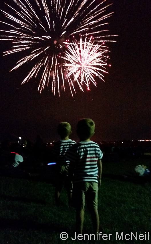
The McNeil twins take in the fireworks on the 4th of July. (Jennifer McNeil)
Colorado offers outdoor opportunities unlike any other state and while the summer heat settles in, photos of the amazing scenes across our state provide a view into why we love it here so much.
The weather this time of year has a pretty standard pattern of quickly warming temperatures followed by afternoon thunderstorms that can cool things down. These storms sometimes provide a good bit of ‘excitement’ and are a prime photo subject.
Slideshow updated July 25, 2016
Recreationalists head outdoors and take advantage of urban, suburban and rural opportunities. As they do, our abundant wildlife that is found just about anywhere comes into focus.
Showcasing images captured by ThorntonWeather.com readers as well as some of our own, our monthly slideshow covers the entire gamut of weather and nature related imagery. Sunsets, sunrises, wildlife and of course every type of weather condition are vividly depicted.
To learn more about how to send your photo to us for inclusion in the slideshow, see below the slideshow.
[flickr_set id=”72157670236285162″]
What is missing in the slideshow above? Your photo!
Our monthly photo slideshow is going to feature images that we have taken but more importantly images that you have captured. The photos can be of anything even remotely weather-related.
Landscapes, current conditions, wildlife, pets, kids. Whimsical, newsy, artsy. Taken at the zoo, some other area attraction, a local park, a national park or your backyard. You name it, we want to see and share it!
Images can be taken in Thornton, Denver or anywhere across the extraordinary Centennial State. We’ll even take some from out of state if we can tie it to Colorado somehow.
We’ll keep the criteria very open to interpretation with just about any image eligible to be shown in our slideshows.
What do you win for having your image in our slideshow? We are just a ‘mom and pop’ outfit and make no money from our site so we really don’t have the means to provide prizes. However you will have our undying gratitude and the satisfaction that your images are shared on the most popular website in Thornton.
To share you images with us and get them included in the slideshow just email them to us or share them with ThorntonWeather.com on any of the various social media outlets. Links are provided below.
Sunday dawned with the very real opportunity to be a scorcher and Mother Nature lived up to her promise. Temperatures rose quickly and brought record-setting mercury readings.
Here in Thornton the mercury topped out at 100.4 degrees at 4:22pm. This was our first 100 degree or higher reading since June 26, 2012.
Out at DIA where Denver’s official readings are taken, the temperature climbed even higher as clouds were slower to move that way. A reading of 102 degrees was made at 4:01pm.
Both readings exceeded the previous record high temperature for July 10 of 99 degrees set in 1955.
The month of June was highly variable, as Colorado’s weather always is. However, high pressure dominated the pattern overall leading to a month with temperatures slightly above normal and precipitation below average.
We started out on the cool side of things and enjoyed a very wet first day of the month. Little did we know that the moisture we received on that day would make up the vast majority of the total for the entire month.
High pressure built and the next 10 days were largely dry and warmer than normal. The 11th, 12th and 13th did finally bring some precipitation to Thornton although the first two of those three days was unseasonably warm.
For the latter half of the month, dry and warm were the key weather words. Temperatures were above normal on 14 of the 17 days and only three days saw precipitation.
Thornton’s overall monthly temperature came in at 71.3 degrees. That is well above Denver’s historical June average of 67.4 degrees. Out at the airport, Denver’s average came in a bit cooler at 70.8 degrees.
Temperatures in Thornton ranged from a high of 98.6 degrees on the 21st down to a low of 47.6 degrees on the 14th. The Mile High City saw its highest reading of 98 degrees on the 21st as well and its coolest of 49 degrees on the 2nd.
In terms of precipitation, Denver averages 1.98 inches during the month of June. Here in Thornton we saw 1.75 inches while DIA recorded 1.62 inches.
Thornton, Colorado’s June 2016 temperature summary. (ThorntonWeather.com)Thornton, Colorado’s June 2016 precipitation summary. (ThorntonWeather.com)
CLIMATE REPORT
NATIONAL WEATHER SERVICE DENVER/BOULDER CO
515 PM MDT SAT JUL 2 2016

...................................

...THE DENVER CO CLIMATE SUMMARY FOR THE MONTH OF JUNE 2016...

CLIMATE NORMAL PERIOD 1981 TO 2010
CLIMATE RECORD PERIOD 1872 TO 2016

WEATHER         OBSERVED          NORMAL  DEPART  LAST YEAR`S
                 VALUE   DATE(S)  VALUE   FROM    VALUE  DATE(S)
                                          NORMAL
................................................................
TEMPERATURE (F)
RECORD
 HIGH             105   06/26/2012
                        06/25/2012
 LOW               30   06/02/1951

HIGHEST            98   06/21
LOWEST             49   06/02
AVG. MAXIMUM     85.5              82.4     3.1     82.9
AVG. MINIMUM     56.2              52.3     3.9     56.1
MEAN             70.8              67.4     3.4     69.5
DAYS MAX >= 90     12               7.9     4.1        6
DAYS MAX <= 32      0               0.0     0.0        0
DAYS MIN <= 32      0               0.0     0.0        0
DAYS MIN <= 0 0 0.0 0.0 0 PRECIPITATION (INCHES) RECORD MAXIMUM 4.96 1882 MINIMUM T 1890 TOTALS 1.62 1.98 -0.36 2.53 DAILY AVG. 0.05 0.07 -0.02 0.08 DAYS >= .01         7               8.4    -1.4       13
DAYS >= .10         4               4.6    -0.6        5
DAYS >= .50         1               1.4    -0.4        2
DAYS >= 1.00        0               0.3    -0.3        0
GREATEST
 24 HR. TOTAL    0.63   06/13 TO 06/13           06/05 TO 06/05

DEGREE_DAYS
HEATING TOTAL       4                62     -58       11
 SINCE 7/1       5560              6058    -498     5583
COOLING TOTAL     185               133      52      154
 SINCE 1/1        188               155      33      158

FREEZE DATES
RECORD
 EARLIEST     09/08/1962
 LATEST       06/08/2007
EARLIEST      04/01             10/07
LATEST        05/08             05/05
..........................................................

WIND (MPH)
AVERAGE WIND SPEED              9.0
RESULTANT WIND SPEED/DIRECTION   3/168
HIGHEST WIND SPEED/DIRECTION    43/270    DATE  06/13
HIGHEST GUST SPEED/DIRECTION    56/260    DATE  06/24

SKY COVER
POSSIBLE SUNSHINE (PERCENT)   MM
AVERAGE SKY COVER           0.50
NUMBER OF DAYS FAIR            8
NUMBER OF DAYS PC             20
NUMBER OF DAYS CLOUDY          2

AVERAGE RH (PERCENT)     52

WEATHER CONDITIONS. NUMBER OF DAYS WITH
THUNDERSTORM             13     MIXED PRECIP               0
HEAVY RAIN                1     RAIN                       3
LIGHT RAIN               11     FREEZING RAIN              0
LT FREEZING RAIN          0     HAIL                       1
HEAVY SNOW                0     SNOW                       0
LIGHT SNOW                0     SLEET                      0
FOG                       7     FOG W/VIS <= 1/4 MILE      0
HAZE                      3

-  INDICATES NEGATIVE NUMBERS.
R  INDICATES RECORD WAS SET OR TIED.
MM INDICATES DATA IS MISSING.
T  INDICATES TRACE AMOUNT.
Weather, natural disasters & climate news and information.
 Following on what was a cool but dry August, some are certainly hoping for a bit of precipitation. The month can bring plenty of rain and even our first snow of the season but more often than not, it is one of the most pleasant along the Colorado Front Range.