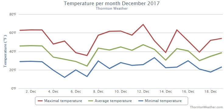
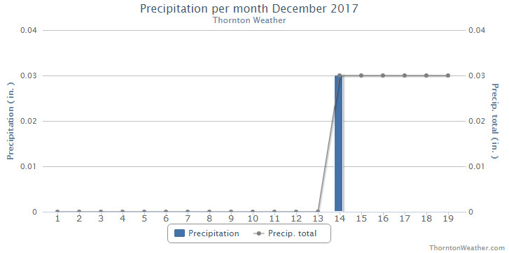
With the last part of December fresh in our minds, it would not be surprising to think of the month as a cold one. However, reaching back, if you recall, we actually enjoyed a lot of mild days earlier and very little precipitation. As a result, December 2017 goes into the books as a warm and dry one.
The first half of the month was notable for stable conditions yielding above normal temperatures and no precipitation. Denver set a record high temperature on the 12th of 69 degrees which was also our warmest reading of the month.
Not long after the warmth came the cold. Arctic air infiltrated from the north on the 21st resulting in much cooler temperatures and a pre-Christmas snow. This was followed by another snow on the 23rd that lasted into the early morning hours of Christmas Eve. Single digit lows were seen for seven days from the 21st to the 27th.
We then saw a brief warmup for the 27th to the 29th but that was short lived. We closed out the month with the final two days’ high temperatures failing to reach even the freezing mark.
On average, Denver’s temperature for December comes in at 30.0 degrees. Both Thornton and the Mile High City came in above that with average readings of 31.8 degrees and 33.2 degrees respectively.
Thornton saw its warmest temperature reading of 69.1 degrees on the 12th and its coldest of 1.6 degrees on the morning of the 27th. Denver’s warmest reading of 69 degrees also came on the 12th and its coldest of -4 degrees came on the 24th.
In terms of precipitation, Thornton saw a mere 0.16 inch of liquid in its bucket for the month. Denver was a bit better with 0.21 inches. Both were below the long-term Denver average of 0.35 inches.
December on average brings 8.5 inches of snowfall to Denver. Thornton fell well short of that with 4.7 inches and Denver just a bit less with 4.0 inches.
Click here to view Thornton’s December 2017 climate report.
CLIMATE REPORT
NATIONAL WEATHER SERVICE DENVER/BOULDER CO
645 AM MST MON JAN 1 2018

...................................

...THE DENVER CO CLIMATE SUMMARY FOR THE MONTH OF DECEMBER 2017...

CLIMATE NORMAL PERIOD 1981 TO 2010
CLIMATE RECORD PERIOD 1872 TO 2017

WEATHER         OBSERVED          NORMAL  DEPART  LAST YEAR`S
                 VALUE   DATE(S)  VALUE   FROM    VALUE  DATE(S)
                                          NORMAL
................................................................
TEMPERATURE (F)
RECORD
 HIGH              79   12/05/1939
 LOW              -25   12/22/1990
                        12/24/1876
HIGHEST            69   12/12        62       7       65  12/30
LOWEST             -4   12/24        -4       0      -15  12/17
AVG. MAXIMUM     48.3              42.8     5.5     42.7
AVG. MINIMUM     18.0              17.1     0.9     12.9
MEAN             33.2              30.0     3.2     27.8
DAYS MAX >= 90      0               0.0     0.0        0
DAYS MAX <= 32      4               5.8    -1.8        6
DAYS MIN <= 32     28              29.4    -1.4       30
DAYS MIN <= 0       1               2.0    -1.0        4

PRECIPITATION (INCHES)
RECORD
 MAXIMUM         5.21   1913
 MINIMUM         0.00   1881
TOTALS           0.21              0.35   -0.14     0.78
DAILY AVG.       0.01              0.01    0.00     0.03
DAYS >= .01         4               4.1    -0.1        6
DAYS >= .10         1               1.1    -0.1        2
DAYS >= .50         0               0.1    -0.1        0
DAYS >= 1.00        0               0.0     0.0        0
GREATEST
 24 HR. TOTAL    0.10   12/23 TO 12/23
 STORM TOTAL     0.10   12/23 TO 12/23

SNOWFALL (INCHES)
RECORDS
 TOTAL           57.4   1913
TOTALS            4.0   2017        8.5

DEGREE_DAYS
HEATING TOTAL     979              1086    -107     1146
 SINCE 7/1       2150              2468    -318     2042
COOLING TOTAL       0                 0       0        0
 SINCE 1/1        881               769     112      878

FREEZE DATES
RECORD
 EARLIEST     09/08/1962
 LATEST       06/08/2007
EARLIEST                        10/07
LATEST                          05/05
.................................................................

WIND (MPH)
AVERAGE WIND SPEED              10.0
RESULTANT WIND SPEED/DIRECTION   2/214
HIGHEST WIND SPEED/DIRECTION    37/270    DATE  12/04
HIGHEST GUST SPEED/DIRECTION    48/280    DATE  12/04

SKY COVER
POSSIBLE SUNSHINE (PERCENT)   MM
AVERAGE SKY COVER           0.50
NUMBER OF DAYS FAIR            8
NUMBER OF DAYS PC             18
NUMBER OF DAYS CLOUDY          5

AVERAGE RH (PERCENT)          49

WEATHER CONDITIONS. NUMBER OF DAYS WITH
FOG OR MIST                   12
FOG VSBY LESS 1/4 MI           4
THUNDER                        0
ICE PELLETS                    0
HAIL                           0
FREEZING RAIN DRIZZLE          0
DUST STORM                     0
SMOKE OR HAZE                  5
BLOWING SNOW                   0
TORNADO                        0

-  INDICATES NEGATIVE NUMBERS.
R  INDICATES RECORD WAS SET OR TIED.
MM INDICATES DATA IS MISSING.
T  INDICATES TRACE AMOUNT.
 As we begin the new year the winter chill begins to set in. While January can see its share of extremes, the month historically sees stable temperatures and is usually relatively dry.

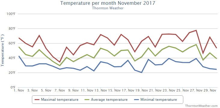
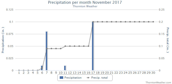
 November proved to be an extraordinarily warm and dry month. Does December have hope for relief?