Severe weather is a fact of life in Colorado – from blizzards to tornadoes we can and do see it all. Each year the weather is responsible for claiming lives in our state and across the nation and the threat is very real. Storm spotter training allows you to learn how to protect yourself and your family while providing a public service.
Education is key to knowing how to protect you and your family. Whether you want to be an official storm spotter or maybe just want to learn more about severe weather, storm spotter training can provide you an incredible opportunity to learn.
The National Weather Service Denver / Boulder office has announced a series of Skywarn storm spotter training dates for Colorado for the 2017 season.
The storm spotter program is a nationwide program with more than 280,000 trained spotters. These volunteers report weather hazards to their local National Weather Service office providing vital information when severe strikes. Data from spotters include severe wind, rain, snow measurements, thunderstorms and hail and of course tornadoes.
Storm spotters are part of the ranks of citizens who form the Nation’s first line of defense against severe weather. There can be no finer reward than to know that their efforts have given communities the precious gift of time–seconds and minutes that can help save lives.
By completing one of these training classes you can become an official storm spotter. When severe weather strikes, you can report it by calling a special toll free number or submit your report via the National Weather Service’s website.
These are great sessions for anyone wanting to learn more about the severe weather we experience in Colorado, whether you want to be an official spotter or not. All training is free. Topics include:
- Basics of thunderstorm development
- Fundamentals of storm structure
- Identifying potential severe weather features
- Information to report
- How to report information
- Basic severe weather safety
To learn more about the program, see here: http://www.crh.noaa.gov/bou/awebphp/spotter.php
Below are the dates, times and locations announced thus far. The embedded calendar should automatically update with new dates and changes but be sure to check the National Weather Service site for the latest.
–> |
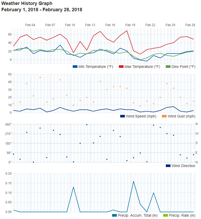


 February in Colorado typically brings to an end an extended period when average temperatures are at their lowest. Winter begins to loosen its grip and temperatures get warmer but precipitation is not a particularly common event during the month.