When the cold of the past 36 hours or so is called “unprecedented”, that is a very accurate statement as Denver has seen three cold temperature records fall.
The latest record set came this morning when the low temperature in Denver as measured at Denver International Airport dropped to 11 degrees. That shatters the previous record low temperature for the date of 15 degrees set in 1933. Thornton stayed warmer but still in record-setting territory with a low of 14 degrees.
A second cold temperature record of the day has fallen.
The high temperature in Denver as measured at Denver International Airport only reached 25 degrees today. That breaks the previous record low maximum for the date of 27 degrees set in 1933. Here in Thornton we were just a touch “warmer” with a high of 26 degrees.
Our spring cold and snow has claimed one record today and may very well break another before the day is over.
As measured at DIA, Denver hit a lot temperature of 15 degrees this morning. That easily breaks the previous record low temperature for the date of 17 degrees set in 1933. Here in Thornton, our low dipped to 16 degrees.
Additionally, the record low maximum for April 13th is 27 degrees, also set in 1933. It is quite possible that we will fail to get that warm and thus set another cold temperature record today.
Tomorrow’s record low is 15 degrees (1933), and with overnight temperatures tonight forecast to dip that low, there is yet another record that may fall.
The month of March was a relatively quiet one for the most part. We didn’t see any particularly notable extremes and only one significant snowstorm.
The month started out on the cool side and we received our first snow of the month on the 2nd. We then put together a stretch lasting two weeks with largely calm and dry conditions.
The 19th offered up a return to wintry conditions as after some rain early in the day, a transition to snow began and we received a healthy 7.5 inches of the white stuff.
Mostly dry conditions were the feature of the last 10 days of the month with a few days seeing temps above normal but most coming in below.
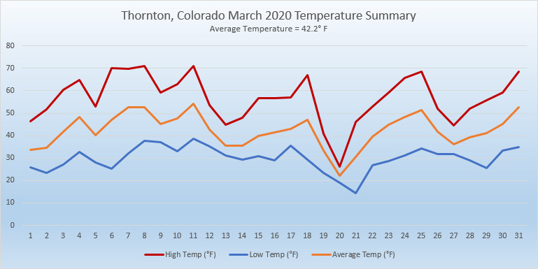
Thornton’s overall average temperature for the month came in at 42.2 degrees. This was a good bit above Denver’s March average of 40.4 degrees. Out at Denver International Airport where the Mile High City’s official records are kept, the reading nearly matched ours at 42.5 degrees.
Our warmest day on the 11th delivered a high of 71.1 degrees while our coldest, the 21st, saw a morning low of 14.2 degrees. Denver’s maximum reading of 68 degrees came on four different days. Their coldest of 11 degrees came on the 21st.
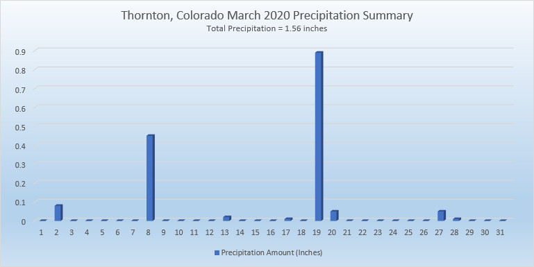
In terms of precipitation, Denver averages 0.92 inches in March. Thornton bested that easily with 1.56 inches and Denver did as well with 1.26 inches.
Both Thornton and Denver fell short of March’s average monthly snowfall of 10.7 inches. Thornton came closest with 9.3 inches while at the airport 7.5 inches was measured.
April marks a transition between winter and summer for most of the country but for Denver it is especially true as we can see a stunning variety of weather.
The proverbial April showers are certainly a possibility for Denver. Snow? Tornadoes? Thunderstorms? You bet – all can happen!
For good measure throw in a chance for hail and even dust storms and April gives every type of weather condition you could like – or hate.
The first sunrise of March 2020 is a stunner. (Alycia Gilliland)
The month of March is the start of meteorological spring and while conditions do begin warming, winter weather is certainly out of the question. From hot to cold, snow to rain, the conditions can be very conducive to great pictures as we see in our slideshow.
March in Denver typically means frequent and rapid weather changes. The days grow longer and we start enjoying more sunshine and sometimes summer-like weather. However, on occasion arctic air masses can still force their way south into Colorado dropping temperatures quickly and markedly.
With the active wildlife, increased outdoor activities by us humans, and of course the weather, March imagery contains a wide variety of subjects and extremes.
Slideshow updated March 31, 2020. To learn more about how to send your photo to us for inclusion in the slideshow, see below the slideshow.
Showcasing images captured by ThorntonWeather.com readers as well as some of our own, our monthly slideshow covers the entire gamut of weather-related imagery.
Sunsets, sunrises, wildlife and of course every type of weather condition are vividly depicted in images captured from yours and our cameras.
[flickr_set id=”72157713421651497″]
What is missing in the slideshow above? Your photo!
Our monthly photo slideshow is going to feature images that we have taken but more importantly images that you have captured. The photos can be of anything even remotely weather-related.
Landscapes, current conditions, wildlife, pets, kids. Whimsical, newsy, artsy. Taken at the zoo, some other area attraction, a local park, a national park or your backyard. You name it, we want to see and share it!
Images can be taken in Thornton, Denver or anywhere across the extraordinary Centennial State. We’ll even take some from out of state if we can tie it to Colorado somehow.
We’ll keep the criteria very open to interpretation with just about any image eligible to be shown in our slideshows.
What do you win for having your image in our slideshow? We are just a ‘mom and pop’ outfit and make no money from our site so we really don’t have the means to provide prizes. However you will have our undying gratitude and the satisfaction that your images are shared on the most popular website in Thornton.
To share you images with us and get them included in the slideshow just email them to us or share them with ThorntonWeather.com on any of the various social media outlets. Links are provided below.
On June 3, 1981 a tornado struck Thornton in what is the worst twister to have struck the Denver metro area. Are you ready should disaster strike again? Image courtesy the City of Thornton archives.
Severe weather is a fact of life in Colorado – from blizzards to tornadoes we can and do see it all. Each year the weather is responsible for claiming lives in our state and across the nation and the threat is very real. Storm spotter training allows you to learn how to protect yourself and your family while providing a public service.
Education is key to knowing how to protect you and your family. Whether you want to be an official storm spotter or maybe just want to learn more about severe weather, storm spotter training can provide you an incredible opportunity to learn.
The storm spotter program is a nationwide program with more than 280,000 trained spotters. These volunteers report weather hazards to their local National Weather Service office providing vital information when severe strikes. Data from spotters include severe wind, rain, snow measurements, thunderstorms and hail and of course tornadoes.
Storm spotters are part of the ranks of citizens who form the Nation’s first line of defense against severe weather. There can be no finer reward than to know that their efforts have given communities the precious gift of time–seconds and minutes that can help save lives.
By completing one of these training classes you can become an official storm spotter. When severe weather strikes, you can report it by calling a special toll free number or submit your report via the National Weather Service’s website.
These are great sessions for anyone wanting to learn more about the severe weather we experience in Colorado, whether you want to be an official spotter or not. All training is free. Topics include:
Below are the dates, times and locations announced thus far. The embedded calendar should automatically update with new dates and changes but be sure to check the National Weather Service site for the latest.
The United States returns to Daylight Saving Time at 2:00am Sunday, March 8, 2020.
The biannual ritual of changing our clocks to adjust for Daylight Saving Time occurs this Saturday night providing yet another signal of the changing of seasons. The United States will ‘spring forward’ one hour at 2:00am Sunday morning as we begin Daylight Saving Time.
The ritual of changing our clocks twice a year can be met with some resistance as some people struggle to adjust their body’s internal clock. The start of Daylight Saving Time can be particularly problematic given the one hour less sleep people receive on the night of the change.
However, longer days as we head into the milder months are a very real benefit and for many worth the inconvenience of a lost hour of sleep. The time change definitely has big effects on how much daylight we enjoy during our normal waking hours.
On Saturday, prior to the change, sunset will occur at 5:59pm but on Sunday the sun won’t disappear over the horizon until 7:00pm. This affords folks more time in the evening to get started on those spring-time chores and allows us to get outside and enjoy the warming weather.
The March Equinox is also on the horizon. Spring officially begins at 9:49pm on Thursday, March 19.
This year Daylight Savings Time will come to an end on November 1.
Some of the recent history of Daylight Savings Time (from Wikipedia):
Daylight saving time in the United States was first observed in 1918. Most areas of the United States currently observe daylight saving time, with the exceptions being the states of Arizona and Hawaii along with the territories of Puerto Rico, American Samoa, Guam, and the Northern Mariana Islands.
From 1987 to 2006, daylight saving time in the United States began on the first Sunday of April and ended on the last Sunday of October. The time was adjusted at 2:00 AM (0200) local time (as it still is done now).
Since 2007, daylight saving time starts on the second Sunday of March and ends on the first Sunday of November, with all time changes taking place at 2:00 AM (0200) local time.
Certainly when you look back on February 2020, you probably will remember it as being cold and snowy. That indeed is true, as the numbers show, however that really only pertained to the first half of the month. The latter part was far more on par with what we expect to see.
The month did start out quite warm as we saw temperature readings well above normal on the first and second. The third, however, brought about significant changes and an end to the warmth that had carried over from January.
Several storm systems moved through over the next 10 days, bringing significantly colder temperatures and regular doses of snow. Indeed, 8 of the first 12 days of the month brought measurable snowfall. Into the third week of the month it appeared we were on pace for one of the coldest Februarys on record.
Things changed again on the 21st and five of the last nine days of the month brought warmer than normal temperatures. This was enough to drive up our average temperature which, while it did come in well below normal, was not in record-setting territory.
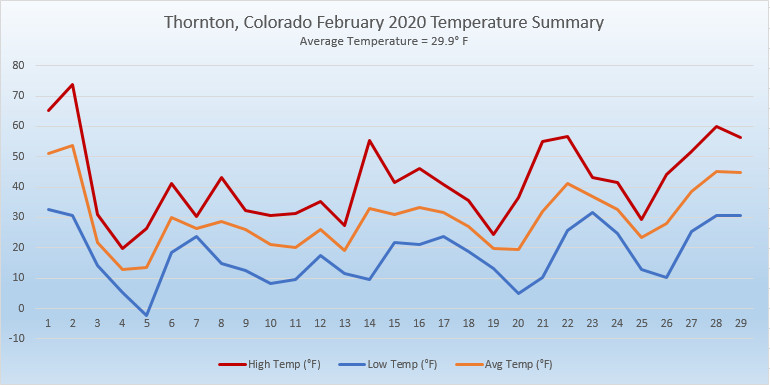
Thornton’s average temperature for the month came in at 29.9 degrees. This was a good ways below Denver’s long term average for February of 32.5 degrees. Out at Denver International Airport where the Mile High City’s official measurements are taken, it actually was colder with an average of 28.1 degrees.
Our temperatures ranged from a high of 73.7 degrees on the 2nd down to a low of -2.2 degrees on the morning of the 5th. Out at DIA, they saw their warmest and coldest temperatures of 74 degrees and -5 degrees on the same dates.
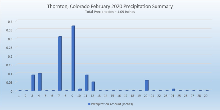
Precipitation came in well above the Denver average for the month of 0.37 inches. Thornton recorded 1.09 inches while Denver measured 0.88 inches.
Snow was of course notable for the first half of the month and drove the monthly totals. On average, Denver receives 5.7 inches in February. Thornton far surpassed that with 22.1 inches and Denver did as well with 16.5 inches of the white stuff.
Thornton, Colorado’s February 2020 Temperature Summary. (ThorntonWeather.com)Thornton, Colorado’s February 2020 Precipitation Summary. (ThorntonWeather.com)
CLIMATE REPORT
NATIONAL WEATHER SERVICE DENVER/BOULDER CO
717 AM MST SUN MAR 1 2020

...................................

...THE DENVER CO CLIMATE SUMMARY FOR THE MONTH OF FEBRUARY 2020...

CLIMATE NORMAL PERIOD 1981 TO 2010
CLIMATE RECORD PERIOD 1872 TO 2020

WEATHER         OBSERVED          NORMAL  DEPART  LAST YEAR`S
                 VALUE   DATE(S)  VALUE   FROM    VALUE  DATE(S)
                                          NORMAL
................................................................
TEMPERATURE (F)
RECORD
 HIGH              80   02/10/2017
 LOW              -25   02/01/1951
                        02/08/1936
HIGHEST            74   02/02        66       8       65  02/03
LOWEST             -5   02/05                -4      -11  02/07
                        02/04
AVG. MAXIMUM     39.9              46.2    -6.3     40.8
AVG. MINIMUM     16.3              18.9    -2.6     15.3
MEAN             28.1              32.5    -4.4     28.0
DAYS MAX >= 90      0               0.0     0.0        0
DAYS MAX <= 32     10               3.9     6.1        8
DAYS MIN <= 32     28              26.9     1.1       26
DAYS MIN <= 0 2 1.3 0.7 3 PRECIPITATION (INCHES) RECORD MAXIMUM 2.01 1934 MINIMUM 0.01 1970 TOTALS 0.88 0.37 0.51 0.72 DAILY AVG. 0.03 0.01 0.02 0.03 DAYS >= .01         9               5.3     3.7        6
DAYS >= .10         4               0.7     3.3        3
DAYS >= .50         0               0.0     0.0        0
DAYS >= 1.00        0               0.0     0.0        0

GREATEST
 24 HR. TOTAL    0.19     02/12

SNOWFALL (INCHES)
TOTALS           16.5               5.7             13.4  2019
RECORD           22.4      2015

DEGREE_DAYS
HEATING TOTAL    1063               908     155     1029
 SINCE 7/1       4499              4468      31     4417
COOLING TOTAL       0                 0       0        0
 SINCE 1/1          0                 0       0        0

FREEZE DATES
RECORD
 EARLIEST     09/08/1962
 LATEST       06/08/2007
EARLIEST                        10/07
LATEST                          05/05
.................................................................

WIND (MPH)
AVERAGE WIND SPEED              10.3
RESULTANT WIND SPEED/DIRECTION   2/212
HIGHEST WIND SPEED/DIRECTION    40/350    DATE  02/25
HIGHEST GUST SPEED/DIRECTION    54/350    DATE  02/25

SKY COVER
POSSIBLE SUNSHINE (PERCENT)   MM
AVERAGE SKY COVER           0.60
NUMBER OF DAYS FAIR            8
NUMBER OF DAYS PC             13
NUMBER OF DAYS CLOUDY          8

AVERAGE RH (PERCENT)     64

-  INDICATES NEGATIVE NUMBERS.
R  INDICATES RECORD WAS SET OR TIED.
MM INDICATES DATA IS MISSING.
T  INDICATES TRACE AMOUNT.
The month of March in Denver is usually one that is welcomed heartily by residents. We begin to shake off the cold of winter with warmer temperatures and calmer conditions. That does not mean we are done with snow and cold by any means.
March usually offers healthy snowfall giving us an opportunity to add to our seasonal totals. While there is good snow potential in March, the month also typically brings much warmer temperatures.
March is historically Denver’s snowiest month and brings about 20% of our annual snowfall. Heavy, wet spring snow storms can oftentimes bring the entire month’s snowfall total in one monstrous snow.
We also start the transition to spring and severe weather season and the month typically brings our first thunderstorms of the year. Temperatures climb throughout the month and by the end our average daytime highs are near 60 degrees.