Thornton, Colorado June 2022 Temperature Summary. Click for larger view.
Last month was one of relatively little drama. Normally we expect June to bring plenty of severe weather but that just was not the case this year. That was, in part, due to a lack of moisture.
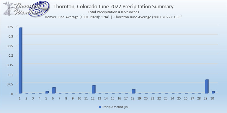
Thornton saw only 0.52 inches in the rain bucket, well-below average. While we did see some hot temperatures (two 98 degree readings being tops), overall the monthly average temp came in right near Thornton’s running 16 year average.
Change is of course the one constant in Denver’s weather but come July, things actually get pretty consistent.
The standard formula for a day in July is a sunny morning, clouds developing in the late morning and early afternoon. Come mid-afternoon, thunderstorms are rolling off of the foothills and into the metro area and the eastern plains. These storms do occasionally reach severe status containing hail, gusty winds and heavy downpours of rain.
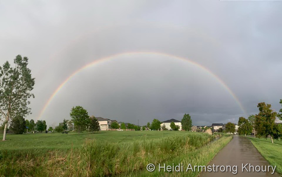
A gorgeous double rainbow after a quick rain shower in Thornton. (Heidi Armstrong Khoury)
The month of June typically sees springtime severe weather reach its height of activity in northeastern Colorado.
This affords the opportunity to capture extraordinary images of amazing weather phenomena from monstrous supercell thunderstorms to heavy rain, hail and even tornadoes.
Slideshow updated June 30, 2022
Showcasing images captured by ThorntonWeather.com readers as well as some of our own, our monthly slideshow covers the entire gamut of weather and nature related imagery.
Sunsets, sunrises, wildlife and of course every type of weather condition are vividly depicted. June brings some very dynamic weather and the photos are a great way to see the stunning variety.
To learn more about how to send your photo to us for inclusion in the slideshow, see below the slideshow.
[flickr_set id=”72177720299575988″]
What is missing in the slideshow above? Your photo!
Our monthly photo slideshow is going to feature images that we have taken but more importantly images that you have captured. The photos can be of anything even remotely weather-related.
Landscapes, current conditions, wildlife, pets, kids. Whimsical, newsy, artsy. Taken at the zoo, some other area attraction, a local park, a national park or your backyard. You name it, we want to see and share it!
Images can be taken in Thornton, Denver or anywhere across the extraordinary Centennial State. We’ll even take some from out of state if we can tie it to Colorado somehow.
We’ll keep the criteria very open to interpretation with just about any image eligible to be shown in our slideshows.
What do you win for having your image in our slideshow? We are just a ‘mom and pop’ outfit and make no money from our site so we really don’t have the means to provide prizes. However you will have our undying gratitude and the satisfaction that your images are shared on the most popular website in Thornton.
To share you images with us and get them included in the slideshow just email them to us or share them with ThorntonWeather.com on any of the various social media outlets. Links are provided below.
Denver’s first 100 degree temperature reading of the year and it goes in the record books.
As measured at Denver International Airport, the city’s official high temperature topped out at 100 degrees. This ties the record high temperature for the date last set in 2013.
Additionally, the reading tied the earliest in the calendar year a 100 degree reading has been seen.
Here in Thornton, we matched the Denver mark at 100 degrees as well.
Time for a break! We will be largely incommunicado for the next week while we take a break to rest and recharge. Look for us to return on June 19th. In the meantime, be sure to visit the website regularly for the latest forecasts, radar, current conditions and more. See you soon!
Extreme weather can occur during in month in Colorado we well know. June however is when traditional spring severe weather arrives in the state oftentimes with hail, damaging wind and tornadoes.
Over 40 percent of the tornadoes that occur in Colorado happen during the month of June. Far more common are thunderstorms with hail and wind, each responsible for extensive damage each year.
While severe weather is common, so too are brilliantly sunny and mild days as we close out spring and enter summer. If you are looking for cold, it isn’t likely but it is possible as the Denver area has seen freezing temperatures and yes, even snow, during the month.
Springtime blooms in Thornton. (ThorntonWeather.com)
Colorado’s famously highly variable weather seems to showcase itself during the month of May when a variety of weather conditions can be seen. This provides a prime opportunity for photos of everything weather to flora to fauna.
The month of May can bring extremes. Snow is not entirely uncommon during the month but more common is severe weather, particularly in the latter half of the month. Thunderstorms become more frequent and their associated hazards – lightning, wind, hail and tornadoes – are usual visitors. Providing additional subjects for pictures are the emerging spring flowers and our abundant wildlife.
Slideshow updated May 30, 2022. To learn more about how to send your photo to us for inclusion in the slideshow, see below the slideshow.
Showcasing images captured by ThorntonWeather.com readers as well as some of our own, our monthly slideshow covers the entire gamut of weather-related imagery.
Sunsets, sunrises, wildlife and of course every type of weather condition are vividly depicted in images captured from yours and our cameras.
[flickr_set id=”72177720298864851″]
What is missing in the slideshow above? Your photo!
Our monthly photo slideshow is going to feature images that we have taken but more importantly images that you have captured. The photos can be of anything even remotely weather-related.
Landscapes, current conditions, wildlife, pets, kids. Whimsical, newsy, artsy. Taken at the zoo, some other area attraction, a local park, a national park or your backyard. You name it, we want to see and share it!
Images can be taken in Thornton, Denver or anywhere across the extraordinary Centennial State. We’ll even take some from out of state if we can tie it to Colorado somehow.
We’ll keep the criteria very open to interpretation with just about any image eligible to be shown in our slideshows.
What do you win for having your image in our slideshow? We are just a ‘mom and pop’ outfit and make no money from our site so we really don’t have the means to provide prizes. However you will have our undying gratitude and the satisfaction that your images are shared on the most popular website in Thornton.
To share you images with us and get them included in the slideshow just email them to us or share them with ThorntonWeather.com on any of the various social media outlets. Links are provided below.
As measured at Denver International Airport, the city’s low temperature bottomed out at 31 degrees. This ties the record low for the date last set in 1931.
Here in Thornton, we actually were just a bit chillier with a low of 31 degrees.
Summer-like conditions took hold today and the mercury climbed to record-setting territory.
As measured at Denver International Airport, the high temperature in the Mile High City topped out at 90 degrees today. This ties the record high for May 11 set in 1961.
The reading was the first 90 degree reading of the season and the fifth earliest we have hit that mark. On average, Denver sees its first 90 degree reading on June 10.
Here in Thornton, we were just a little cooler with a high of 89 degrees.
As measured at Denver International Airport, the Mile High City topped out at 89 degrees today. This bests the previous record high temperature for May 7 of 87 degrees set in 1989.
Here in Thornton, we matched the Denver mark with a high of 89 degrees as well.
Weather, natural disasters & climate news and information.


 Extreme weather can occur during in month in Colorado we well know. June however is when traditional spring severe weather arrives in the state oftentimes with hail, damaging wind and tornadoes.