 A Red Flag Warning has been issued for most of the state as warm temperatures and low humidities have increased the danger of fires getting out of control. This was witnessed first hand last week with the four wildfires in southern Colorado that quickly got out of hand.
Further, the AP is reporting that while we have had record snowpack this winter, that doesn’t necessarily translate to decreased fire danger.
Wildfire experts say the problem is the winter was short, which means the trees and plants absorbed less moisture than if the snow cover had been around longer.
They say that’s one of the factors behind a fire near Carbondale last week that burned 1 and 1/2 square miles.
Capt. Shaun Moore of the Greater Eagle Fire Protection District says the snowpack could actually boost the wildfire risk because the snow has helped grass grow taller. That could make it easier for flames to leap to trees when the grass dries out.
PLEASE be careful out there!
A RED FLAG WARNING REMAINS IN EFFECT FROM NOON TODAY TO 8 PM MDT THIS EVENING.
GUSTY SOUTHWEST WINDS AND VERY LOW RELATIVE HUMIDITIES ARE EXPECTED THIS AFTERNOON INTO THE EARLY EVENING HOURS. AS A RESULT A RED FLAG WARNING HAS BEEN ISSUED FROM 12 PM TO 8 PM MDT. AREAS IN THE WARNING WILL AGAIN INCLUDE THE INTERSTATE 25 CORRIDOR AND NORTHEAST PLAINS OF COLORADO.
SOUTHWEST WINDS OF 15 TO 30 MPH WITH A FEW HIGHER GUSTS CAN BE EXPECTED THIS AFTERNOON AND WILL CONTINUE INTO THE EARLY EVENING HOURS. IN ADDITION…RELATIVE HUMIDITY WILL DROP TO AROUND 10 PERCENT. THE GUSTY WINDS AND LOW HUMIDITIES WILL COMBINE WITH DRY FUELS TO CREATE CRITICAL FIRE CONCERNS THROUGH EARLY THIS EVENING.
A RED FLAG WARNING MEANS THAT CRITICAL FIRE WEATHER CONDITIONS ARE EITHER OCCURRING OR IMMINENT.
 April marks a transition between winter and summer for most of the country but for Denver it is especially true as we can see a stunning variety of weather. The proverbial April showers are certainly a possibility for Denver. Snow? Tornadoes? Thunderstorms? You bet – all can happen! For good measure throw in a chance for hail and even dust storms and April gives every type of weather condition you could like – or hate.
  First, the good news. With the extraordinary amount of snow the mountains have experienced this winter, the chances of drought are negligible for most of the state. The southeastern corner of Colorado however could see some risk.
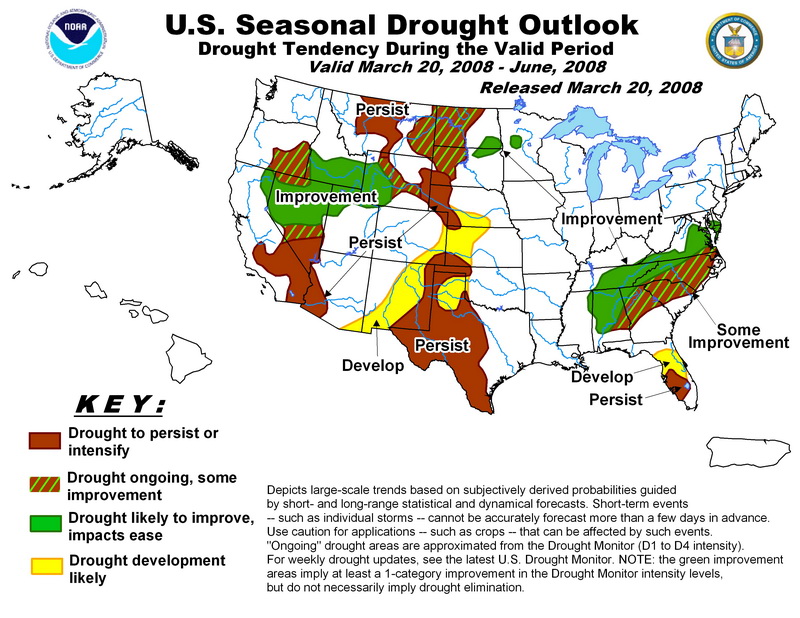
 This week NOAA’s National Climatic Data Center announced that from December 2007 to February 2008 temperatures across the United States and the globe were their coolest since 2001. In the contiguous United States, the average winter temperature was 33.2°F which ranks it as the 54th coolest winter since national records began in 1895. Globally, the combined land and ocean surface temperature was the 16th warmest on record for the period.
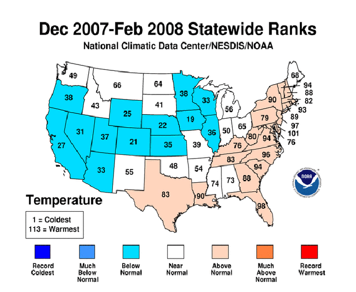

 March in Denver typically means frequent and rapid weather changes. The days grow longer and we start enjoying more sunshine and sometimes summer-like weather. However, on occasion arctic air masses can still force their way south into Colorado dropping temperatures quickly and markedly. Occasional thunderstorms do start to happen in March as well.
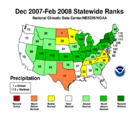