The first quarter of the year started out dry but April started to signal a turn toward wetter conditions and the month of May certainly followed through on that. Not only was it a very wet month, it was also much cooler than normal.
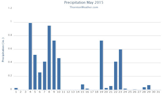
A seemingly endless series of disturbances moved through the state almost from the first day through the last day of May 2015. We started out dry but the third of the month began the wet period with five straight days of precipitation. That was capped off by a decent shot of snowfall on the 10th of the month.
After that we did dry out for at least a few days before the wet weather returned on the 15th, albeit with lesser amounts of precipitation overall. By the time the month was over, 18 of the 31 days had seen measureable precipitation in Thornton.
Temperatures were quite cool for the month with the average in Thornton coming in at 52.2 degrees. This was nearly five degrees below Denver’s May average of 57.1 degrees. As measured at Denver International Airport, the Mile High City officially saw an overage of 53.0 degrees.
Thornton’s mercury readings ranged from a high of 87.3 degrees on the 31st down to a low of 27.8 degrees on the morning of the 10th. Denver saw its warmest reading of 85 degrees on the 31st also and its coldest reading of 27 degrees occurred on the 9th and 10th.
In terms of precipitation, the numbers help to showcase just how wet of a month it was. Here in Thornton we recorded 6.40 inches of liquid precipitation, far above the long term Denver average for May of 2.12 inches. Officially, Denver also saw above normal precipitation although not by near as much as they recorded 3.76 inches.
That reading was not enough to push May 2015 into the books as one of the top 10 wettest Mays. However, the airport’s outlying location as compared to historical measurement sites is probably the only reason why. As Thornton’s measurement and those of other station’s shows, we were far wetter than what DIA saw.
Snowfall in May is not unusual and Thornton saw 5.1 inches from one storm on the 9th and 10th. Out at the airport 4.0 inches was recorded. Both were a good bit above the May average of 1.1 inches.
Click here to view Thornton’s May 2015 climate report.

CLIMATE REPORT
NATIONAL WEATHER SERVICE BOULDER, CO
645 AM MDT MON JUN 1 2015

...................................

...THE DENVER CO CLIMATE SUMMARY FOR THE MONTH OF MAY 2015...

CLIMATE NORMAL PERIOD 1981 TO 2010
CLIMATE RECORD PERIOD 1872 TO 2015

WEATHER         OBSERVED          NORMAL  DEPART  LAST YEAR`S
                 VALUE   DATE(S)  VALUE   FROM    VALUE  DATE(S)
                                          NORMAL
................................................................
TEMPERATURE (F)
RECORD
 HIGH              95   05/26/1942
 LOW               19   05/02/2013
                        05/03/1907
HIGHEST            85   05/31                         87  05/28
                                                          05/29
LOWEST             27   05/10                         30  05/12
                        05/09
AVG. MAXIMUM     63.3              71.5    -8.2     70.6
AVG. MINIMUM     42.7              42.7     0.0     44.5
MEAN             53.0              57.1    -4.1     57.5
DAYS MAX >= 90      0               0.8    -0.8        0
DAYS MAX <= 32      0               0.0     0.0        0
DAYS MIN <= 32      3               1.9     1.1        4
DAYS MIN <= 0       0               0.0     0.0        0
PRECIPITATION (INCHES)
RECORD
  MAXIMUM         8.57   1876
  MINIMUM         0.06   1974
TOTALS           3.76              2.12    1.64     3.51
DAILY AVG.       0.12              0.07    0.05     0.11
DAYS >= .01        19               9.4     9.6       13
DAYS >= .10        10               4.8     5.2        6
DAYS >= .50         2               1.2     0.8        3
DAYS >= 1.00        1               0.2     0.8        1
GREATEST
 24 HR. TOTAL    1.18   05/08 TO 05/09           05/20 TO 05/21

SNOWFALL (INCHES)
TOTAL             4.0               1.1
RECORD MAY       15.5                                      1898

DEGREE_DAYS
HEATING TOTAL     367               265     102      244
 SINCE 7/1       5572              5996    -424     5974
COOLING TOTAL       4                21     -17       21
 SINCE 1/1          4                22     -18       21

FREEZE DATES
RECORD
 EARLIEST     09/08/1962
 LATEST       06/08/2007
NORMAL
 EARLIEST                         10/07
 LATEST                           05/05
..................................................

WIND (MPH)
AVERAGE WIND SPEED              9.3
RESULTANT WIND SPEED/DIRECTION   2/106
HIGHEST WIND SPEED/DIRECTION    45/280    DATE  05/02
HIGHEST GUST SPEED/DIRECTION    54/280    DATE  05/02

SKY COVER
POSSIBLE SUNSHINE (PERCENT)   MM
AVERAGE SKY COVER           0.80
NUMBER OF DAYS FAIR            0
NUMBER OF DAYS PC             15
NUMBER OF DAYS CLOUDY         16

AVERAGE RH (PERCENT)     70

WEATHER CONDITIONS. NUMBER OF DAYS WITH
THUNDERSTORM              0     MIXED PRECIP               0
HEAVY RAIN                2     RAIN                       9
LIGHT RAIN               23     FREEZING RAIN              0
LT FREEZING RAIN          0     HAIL                       0
HEAVY SNOW                1     SNOW                       1
LIGHT SNOW                2     SLEET                      0
FOG                      14     FOG W/VIS <= 1/4 MILE      7
HAZE                      3

-  INDICATES NEGATIVE NUMBERS.
R  INDICATES RECORD WAS SET OR TIED.
MM INDICATES DATA IS MISSING.
T  INDICATES TRACE AMOUNT.
 Extreme weather can occur during in month in Colorado we well know. June however is when traditional spring severe weather arrives in the state oftentimes with hail, damaging wind and tornadoes.


 Denver’s weather rollercoaster this week took us from cold and snow to unseasonably warm temperatures sure to bring an onset of spring fever. The Mile High City set a record high temperature Friday and may set another Saturday.
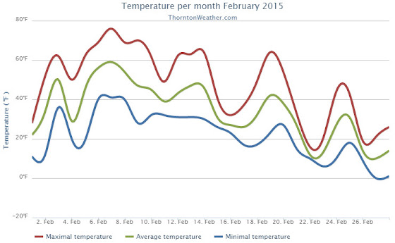
 February in Colorado typically brings to an end an extended period when average temperatures are at their lowest. Winter begins to loosen its grip and temperatures get warmer but precipitation is not a particularly common event during the month.