The mild temperatures have put a record in the books for December 11.
As measured at Denver International Airport, the date saw a low temperature of 45 degrees. This breaks the previous record high minimum of 44 degrees for the date set in 1933.
Here in Thornton we were considerably warmer overnight and early morning. Our low temperatures as a mild 56.3 degrees.
Thornton, Colorado’s November 2025 Temperature Summary. (ThorntonWeather.com)
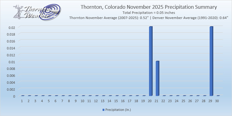
Yet another month in the books with mercury readings well above average and precipitation lighter than average. In fact, November 2025 goes into the books as the warmest and second driest November in Thornton of the past 19 years.
During the month there was a complete lack of notable weather events – beyond the warmth and dryness. It wasn’t until the third week of the month that we saw any precipitation and then it was a minimal amount of rain.
On the 28th, we finally received our first snowfall of the season, but it was a meager amount (0.6 inches). It also was the second latest first seasonal snowfall ever recorded in Denver.
Overall, Thornton’s November 2025 average temperature was 45.8 degrees. This is far above our 19-year running average temperature for November of 39.9 degrees. It also makes the month the warmest November recorded over that same period.
For Denver, as recorded at Denver International Airport, it was similarly mild. The average temperature was 45.1 degrees. This was 5.7 degrees above the city’s long-term average.
Precipitation was pitiful for the month. Thornton recorded a mere 0.05 inches during the month. This is far below our running average for November of 0.52 inches.
The Mile High City recorded 0.09 inches of precipitation in their bucket. This is far below Denver’s long-term average for November of 0.64 inches.
As previously stated, snow was virtually non-existent during the month. The 28th offered the first snow of the season in Thornton and only totaled 0.6 inches. The month’s total fell far short of our 19-year average of 5.9 inches.
Denver recorded only 0.2 inches of the white stuff at DIA. This was far below the 7.3 inch average for November in the Mile High City.
Recent months have, overall, been mostly warmer and drier than normal. What will December hold for us?
The month of December brings with it the official start of winter and oftentimes, colder and snowier weather conditions. It, however, can also offer unseasonably warm temperatures and bone dry conditions. Given our recent mild and dry weather, we are certainly hoping for a change in the coming month.
Overall December’s monthly mean temperature of 31.2 degrees (1991 – 2020 averages) makes it our coldest month. Snow is always on everyone’s mind this time of year but December is only our 3rd snowiest month behind March and November with an average of 8.0 inches of the white stuff.
Thornton, Colorado’s October 2025 Temperature Summary. (ThorntonWeather.com)
Thornton’s first full month of fall for the year yielded lots of dry mild days. While that made for some pleasant conditions, it was exceedingly warm and dry.
The month started out with mercury readings in the 80s for the first four days then we cooled down. Three days with readings closer to normal followed as did some nice rain.
We then strung together more than two weeks of largely above average temperatures and very minimal precipitation. The final five days did cool down some and bring a little bit more rain.
Thornton’s overall average temperature for the month came in at 52.9 degrees. This was well above our running 19-year average for the month of 50.1 degrees. Temperatures ranged from a high of 87.8 degrees on the 3rd down to a low of 22.6 degrees on the morning of the 29th.
Out at DIA where Denver’s official measurements are taken, it was a bit warmer. The Mile High City saw an average temperature for the month of 53.5 degrees, well above their long term average for October of 51.1 degrees.
In terms of precipitation, it was lacking a good bit. Thornton recorded 0.56 inches in its rain bucket, the vast majority of it (0.50”) coming on the 5th and 6th. This was much less than our running October average of 0.94 inches.
At the airport, Denver was even drier. They saw a mere 0.14 inches in the bucket, far less than the Mile High City’s October average of 0.99 inches.
No snow was recorded in Thornton or in Denver. This already puts us at a deficit to start the snow season. On average, Thornton receives 3.6 inches in October.
It was ridiculously warm today, certainly something we would expect to see in early October, not November. The mercury readings resulted in Denver setting two records.
The high temperature, as measured at Denver International Airport, reached 83 degrees. This sets a new high temperature record for the date, besting the old record of 78 degrees set in 1931.
Also, the 83 degree reading sets a record high temperature for the month of November. The previous warmest November reading was 81 degrees on November 27, 2017.
Here in Thornton, we also topped out at 83 degrees. This was the warmest November 2nd and the warmest November reading overall in the 19 years this station has been in operation.
80 degree readings in November are a rarity. In fact, today’s is only the fifth in Denver since record keeping began in 1872.
The weather during the month of November in Denver metro area can offer just about anything. While it is normally a quiet month, it can be prone to extremes.
November has historically been one of Denver’s snowiest months and major snowstorms are not entirely uncommon. However conditions can also be quite dry.
Temperatures during the month continue to cool as we get closer to winter and by the end of the month the low temperatures routinely dip to 20 degrees or below. At times it can in fact bring conditions more like what we see in January.
Thornton, Colorado’s September 2025 temperature summary. (ThorntonWeather.com)
Thornton was finally able to break out of the hot, dry weather pattern of recent months and see things get a bit more normal. September historically is one of our most pleasant months and 2025 largely held true to that.
We did start out pretty mild and precipitation was meager for the first half of the month. Finally, on the 13th, we began to see things cool down and then on the 16th got a nice shot of rain (0.61”).
The rest of the month offered mild but comfortable temperatures. A strong trough on the 23rd cooled us considerably with that day offering high temperatures nearly 20 degrees below normal. It also brought a very healthy shot of rain (1.21″).
In the end, the average temperature for the month of September ended up very close to average. Thornton’s average for the month was 64.6 degrees. This was just a hair higher than our 19 year running average for the month of 64.3 degrees. Our maximum temperature for the month was 92 degrees and came on the 10th. Our coolest reading of 42.3 degrees was on the 25th.
For Denver, at Denver International Airport where the Mile High City’s official measurements are taken, temperatures were on par with ours. They reported an average for the month of 64.7 degrees. This was close to their long term average for September of 64.8 degrees.
In terms of precipitation, Thornton saw a notable 2.09 inches for the month. This was far above our 19-year running average of 1.51 inches for September. This was the fourth wettest September over that period.
The Mile High City was quite a bit drier with 1.35 inches recorded in their rain bucket. It was, however, above their long term average for the month of 1.09 inches.
No snow was recorded in Thornton or Denver for the month.
With the first full month of fall here, October usually brings one of the quietest weather months in the Denver area with plenty of mild, sunny days and clear, cool nights.
October is historically the second sunniest month and conditions are generally calm.
However we also will usually see our first taste of winter during the month with the first freeze and first snowfall of the season. Temperatures as well will start to drop and by the end of the month the average nighttime lows are below freezing.
Thornton, Colorado temperature summary for August 2025. (ThorntonWeather.com)
A recurring theme from most of 2025 for August. Thornton once again saw temperatures above normal and precipitation below, something that has happened far too often this year.
Above normal temperatures dominated the first three weeks of the month. Mercury readings in the 90s were common with only three days being below that mark. Precipitation was absolutely scarce with a mere 0.01 inches being recorded during the first 21 days of the month.
Thankfully, Mother Nature took mercy on us for the last 10 days of August. We saw temperatures cool a good bit with every day seeing below average readings. While precipitation wasn’t great, she also was kind enough to finally give us a couple days with much-needed rain.
Temperatures in Thornton came in at an average of 72.6 degrees for the month. This was a good bit above the 19-year running average for August of 71.8 degrees. It was also the sixth month in a row for Thornton with above average temperatures.
Out at DIA where Denver’s official records are taken, it was a good bit warmer. The Mile High City saw an average of 73.8 degrees for August 2025. This was above their long term average for August of 72.9 degrees.
In terms of precipitation, Thornton ended up with 0.51 inches in the bucket. Virtually all of that fell in the last seven days of the month. It was well below our running August average of 1.20 inches.
For Denver, they saw two days with thunderstorms that dumped a great deal of rain on the airport, storms that missed us. As a result, their rain total for the month was a surprising 4.12 inches. This was well above their long term average for August of 1.58 inches.
Following an August that was unseasonably warm, we find ourselves heading into September hoping for relief. The month can bring plenty of rain and even our first snow of the season but more often than not, it is one of the most pleasant along the Colorado Front Range.
As temperatures start to drop, September usually reminds us that summer is at an end and fall is now here. Sunshine is predominant though as the month actually has the highest percentage of sun out of any month. Sunny days and clear, cool nights are the standard weather pattern for the month.
The month can bring extremes however. We will of course forever remember 2013’s devastating floods brought on by record-setting rain. Longtime residents might remember September 1971 which brought over 17 inches of snowfall.