The month of March was a relatively quiet one for the most part. We didn’t see any particularly notable extremes and only one significant snowstorm.
The month started out on the cool side and we received our first snow of the month on the 2nd. We then put together a stretch lasting two weeks with largely calm and dry conditions.
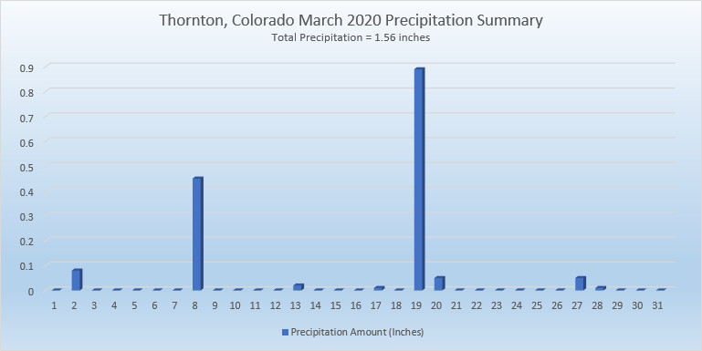
The 19th offered up a return to wintry conditions as after some rain early in the day, a transition to snow began and we received a healthy 7.5 inches of the white stuff.
Mostly dry conditions were the feature of the last 10 days of the month with a few days seeing temps above normal but most coming in below.
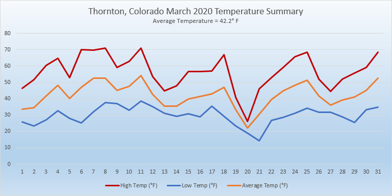
Thornton’s overall average temperature for the month came in at 42.2 degrees. This was a good bit above Denver’s March average of 40.4 degrees. Out at Denver International Airport where the Mile High City’s official records are kept, the reading nearly matched ours at 42.5 degrees.
Our warmest day on the 11th delivered a high of 71.1 degrees while our coldest, the 21st, saw a morning low of 14.2 degrees. Denver’s maximum reading of 68 degrees came on four different days. Their coldest of 11 degrees came on the 21st.
In terms of precipitation, Denver averages 0.92 inches in March. Thornton bested that easily with 1.56 inches and Denver did as well with 1.26 inches.
Both Thornton and Denver fell short of March’s average monthly snowfall of 10.7 inches. Thornton came closest with 9.3 inches while at the airport 7.5 inches was measured.
April marks a transition between winter and summer for most of the country but for Denver it is especially true as we can see a stunning variety of weather.
The proverbial April showers are certainly a possibility for Denver. Snow? Tornadoes? Thunderstorms? You bet – all can happen!
For good measure throw in a chance for hail and even dust storms and April gives every type of weather condition you could like – or hate.
Certainly when you look back on February 2020, you probably will remember it as being cold and snowy. That indeed is true, as the numbers show, however that really only pertained to the first half of the month. The latter part was far more on par with what we expect to see.
The month did start out quite warm as we saw temperature readings well above normal on the first and second. The third, however, brought about significant changes and an end to the warmth that had carried over from January.
Several storm systems moved through over the next 10 days, bringing significantly colder temperatures and regular doses of snow. Indeed, 8 of the first 12 days of the month brought measurable snowfall. Into the third week of the month it appeared we were on pace for one of the coldest Februarys on record.
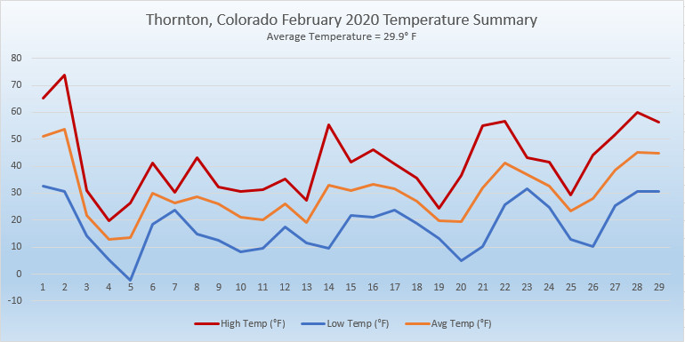
Things changed again on the 21st and five of the last nine days of the month brought warmer than normal temperatures. This was enough to drive up our average temperature which, while it did come in well below normal, was not in record-setting territory.
Thornton’s average temperature for the month came in at 29.9 degrees. This was a good ways below Denver’s long term average for February of 32.5 degrees. Out at Denver International Airport where the Mile High City’s official measurements are taken, it actually was colder with an average of 28.1 degrees.
Our temperatures ranged from a high of 73.7 degrees on the 2nd down to a low of -2.2 degrees on the morning of the 5th. Out at DIA, they saw their warmest and coldest temperatures of 74 degrees and -5 degrees on the same dates.
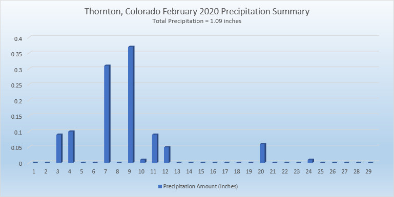
Precipitation came in well above the Denver average for the month of 0.37 inches. Thornton recorded 1.09 inches while Denver measured 0.88 inches.
Snow was of course notable for the first half of the month and drove the monthly totals. On average, Denver receives 5.7 inches in February. Thornton far surpassed that with 22.1 inches and Denver did as well with 16.5 inches of the white stuff.
Thornton, Colorado’s February 2020 Temperature Summary. (ThorntonWeather.com)Thornton, Colorado’s February 2020 Precipitation Summary. (ThorntonWeather.com)
CLIMATE REPORT
NATIONAL WEATHER SERVICE DENVER/BOULDER CO
717 AM MST SUN MAR 1 2020

...................................

...THE DENVER CO CLIMATE SUMMARY FOR THE MONTH OF FEBRUARY 2020...

CLIMATE NORMAL PERIOD 1981 TO 2010
CLIMATE RECORD PERIOD 1872 TO 2020

WEATHER         OBSERVED          NORMAL  DEPART  LAST YEAR`S
                 VALUE   DATE(S)  VALUE   FROM    VALUE  DATE(S)
                                          NORMAL
................................................................
TEMPERATURE (F)
RECORD
 HIGH              80   02/10/2017
 LOW              -25   02/01/1951
                        02/08/1936
HIGHEST            74   02/02        66       8       65  02/03
LOWEST             -5   02/05                -4      -11  02/07
                        02/04
AVG. MAXIMUM     39.9              46.2    -6.3     40.8
AVG. MINIMUM     16.3              18.9    -2.6     15.3
MEAN             28.1              32.5    -4.4     28.0
DAYS MAX >= 90      0               0.0     0.0        0
DAYS MAX <= 32     10               3.9     6.1        8
DAYS MIN <= 32     28              26.9     1.1       26
DAYS MIN <= 0 2 1.3 0.7 3 PRECIPITATION (INCHES) RECORD MAXIMUM 2.01 1934 MINIMUM 0.01 1970 TOTALS 0.88 0.37 0.51 0.72 DAILY AVG. 0.03 0.01 0.02 0.03 DAYS >= .01         9               5.3     3.7        6
DAYS >= .10         4               0.7     3.3        3
DAYS >= .50         0               0.0     0.0        0
DAYS >= 1.00        0               0.0     0.0        0

GREATEST
 24 HR. TOTAL    0.19     02/12

SNOWFALL (INCHES)
TOTALS           16.5               5.7             13.4  2019
RECORD           22.4      2015

DEGREE_DAYS
HEATING TOTAL    1063               908     155     1029
 SINCE 7/1       4499              4468      31     4417
COOLING TOTAL       0                 0       0        0
 SINCE 1/1          0                 0       0        0

FREEZE DATES
RECORD
 EARLIEST     09/08/1962
 LATEST       06/08/2007
EARLIEST                        10/07
LATEST                          05/05
.................................................................

WIND (MPH)
AVERAGE WIND SPEED              10.3
RESULTANT WIND SPEED/DIRECTION   2/212
HIGHEST WIND SPEED/DIRECTION    40/350    DATE  02/25
HIGHEST GUST SPEED/DIRECTION    54/350    DATE  02/25

SKY COVER
POSSIBLE SUNSHINE (PERCENT)   MM
AVERAGE SKY COVER           0.60
NUMBER OF DAYS FAIR            8
NUMBER OF DAYS PC             13
NUMBER OF DAYS CLOUDY          8

AVERAGE RH (PERCENT)     64

-  INDICATES NEGATIVE NUMBERS.
R  INDICATES RECORD WAS SET OR TIED.
MM INDICATES DATA IS MISSING.
T  INDICATES TRACE AMOUNT.
The month of March in Denver is usually one that is welcomed heartily by residents. We begin to shake off the cold of winter with warmer temperatures and calmer conditions. That does not mean we are done with snow and cold by any means.
March usually offers healthy snowfall giving us an opportunity to add to our seasonal totals. While there is good snow potential in March, the month also typically brings much warmer temperatures.
March is historically Denver’s snowiest month and brings about 20% of our annual snowfall. Heavy, wet spring snow storms can oftentimes bring the entire month’s snowfall total in one monstrous snow.
We also start the transition to spring and severe weather season and the month typically brings our first thunderstorms of the year. Temperatures climb throughout the month and by the end our average daytime highs are near 60 degrees.
4February in Colorado typically brings to an end an extended period when average temperatures are at their lowest. Winter begins to loosen its grip and temperatures get warmer but precipitation is not a particularly common event during the month.
Thus far, our snow season has been a mixed bag. We started fast in October and November but December and January added very little to the totals. February is only our sixth snowiest month so we may not see much snowfall for the balance of the month.
Temperatures however do usually see a nice rebound during the month. Average high temperatures climb from an average of 44 degrees at the start to 50 degrees by the end of February.
After a cold and snowy start to the season in October and November, December saw things dry out and warm up. Unfortunately, January 2020 continued the most recent trend with temps well above normal and very little precipitation.
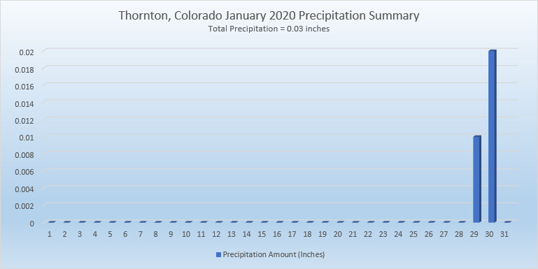
The month was largely uneventful with no notable weather events. Daytime high temperatures were routinely warmer than normal and no precipitation was seen until the very end of the month. When we did finally see some snow on the 29th and 30th, it was minimal, amounting to little more than a dusting.
Thornton’s overall average temperature for the month came in at 34.1 degrees. This is well above the long term Denver average for January of 30.7 degrees. As usual, the Mile High City’s official reading at Denver International Airport came in warmer than us at 34.6 degrees.
Temperatures in Thornton ranged from a high of 61.4 degrees on the 4th down to a low of 10.8 degrees on the 11th. Denver saw its maximum reading of 62 degrees on the 4th and 8th and its lowest of 7 degrees on the 11th.
In terms of precipitation, Denver averages 0.27 inches in January. Both Thornton and Denver fell well short with 0.03 inches and 0.14 inches respectively.
Snow was in short supply with 0.6 inches falling in Thornton and 0.9 inches in Denver. Both were far short of the average of 7 inches for Denver in January.
In the end, the month was Thornton’s warmest, driest and least snowy January since ThorntonWeather.com came online in 2007.
Thornton, Colorado’s January 2020 temperature summary. Click for larger view. (ThorntonWeather.com)Thornton, Colorado’s January 2020 precipitation summary. Click for larger view. (ThorntonWeather.com)
From the National Weather Service:
CLIMATE REPORT
NATIONAL WEATHER SERVICE DENVER/BOULDER CO
717 AM MST SAT FEB 1 2020

...................................

...THE DENVER CO CLIMATE SUMMARY FOR THE MONTH OF JANUARY 2020...

CLIMATE NORMAL PERIOD 1981 TO 2010
CLIMATE RECORD PERIOD 1872 TO 2020

WEATHER         OBSERVED          NORMAL  DEPART  LAST YEAR`S
                 VALUE   DATE(S)  VALUE   FROM    VALUE  DATE(S)
                                          NORMAL
................................................................
TEMPERATURE (F)
RECORD
 HIGH              76   01/27/1888
 LOW              -29   01/09/1875
HIGHEST            62   01/08        76     -14       62  01/04
                        01/04
LOWEST              7   01/11       -29      36       -5  01/01
AVG. MAXIMUM     48.0              44.0     4.0     44.6
AVG. MINIMUM     21.1              17.4     3.7     19.5
MEAN             34.6              30.7     3.9     32.0
DAYS MAX >= 90      0               0.0     0.0        0
DAYS MAX <= 32      1               5.5    -4.5        6
DAYS MIN <= 32     31              29.4     1.6       29
DAYS MIN <= 0 0 1.7 -1.7 1 PRECIPITATION (INCHES) RECORD MAXIMUM 2.35 1883 MINIMUM 0.01 1933 1934 1952 TOTALS 0.14 0.41 -0.27 0.75 DAILY AVG. 0.00 0.01 -0.01 0.02 DAYS >= .01         2               4.1    -2.1        6
DAYS >= .10         1               0.9     0.1        2
DAYS >= .50         0               0.0     0.0        0
DAYS >= 1.00        0               0.0     0.0        0
GREATEST
 24 HR. TOTAL    0.13   01/27

SNOWFALL (INCHES)
TOTALS            0.9               7.0              6.2   2019
RECORD           24.3   1992
TOTAL

DEGREE_DAYS
HEATING TOTAL     937              1063    -126     1016
 SINCE 7/1       3436              3531     -95     3388
COOLING TOTAL       0                 0       0        0
 SINCE 1/1          0                 0       0        0

FREEZE DATES
RECORD
 EARLIEST     09/08/1962
 LATEST       06/08/2007
EARLIEST                        10/07
LATEST                          05/05
.................................................................

WIND (MPH)
AVERAGE WIND SPEED              10.1
RESULTANT WIND SPEED/DIRECTION   4/220
HIGHEST WIND SPEED/DIRECTION    40/290    DATE  01/01
HIGHEST GUST SPEED/DIRECTION    53/290    DATE  01/01

SKY COVER
POSSIBLE SUNSHINE (PERCENT)   MM
AVERAGE SKY COVER           0.50
NUMBER OF DAYS FAIR           10
NUMBER OF DAYS PC             17
NUMBER OF DAYS CLOUDY          4

AVERAGE RH (PERCENT)     49

-  INDICATES NEGATIVE NUMBERS.
R  INDICATES RECORD WAS SET OR TIED.
MM INDICATES DATA IS MISSING.
T  INDICATES TRACE AMOUNT.
We closed out 2019 with a change from the cool, wet conditions of the previous two months. December saw the opposite conditions as average temperatures were above normal and snow a rarity.
Storm systems did move through Colorado and the Rocky Mountain region and while the high country saw plenty of snow, these storms evaded the Front Range for most of the month. Temperatures were never particularly warm but overall, the average temp was warmer than normal in Thornton.
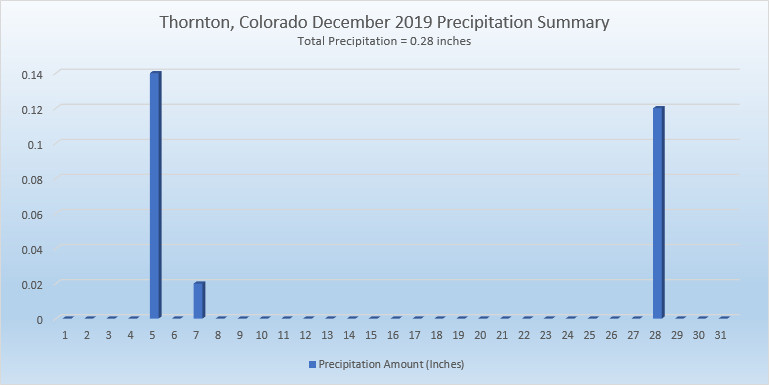
On the 5th of the month, we saw a respectable bit of rain instead of snow. Finally, a light snowfall on the 14th was the first snow of the month. We then stayed dry until the 28th when we received our first – and only – appreciable snowfall of the month.
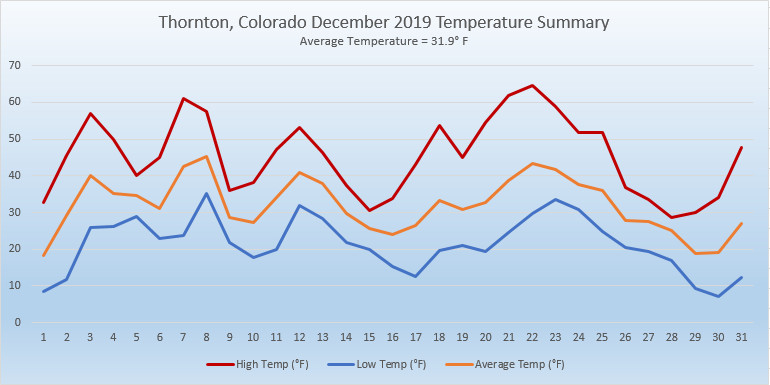
Thornton’s overall average temperature for the month came in at 31.9 degrees. This was a good bit warmer than Denver’s long term average for December of 30.0 degrees. Out at Denver International Airport where the Mile High City’s official records are kept, it was warmer with an average of 33.7 degrees.
Temperatures in Thornton ranged from a high of 64.6 degrees on the 22nd down to a low of 7.2 degrees on the morning of the 30th. Denver recorded a maximum of 67 degrees and its minimum of 3 degrees on the same dates.
In terms of precipitation, Denver averages 0.35 inches during December. Thornton fell short of that with 0.28 inches while Denver had just a touch more with 0.30 inches.
A mere 2.8 inches of snow was recorded in Thornton during the month and Denver had an identical number. These were well short of the 8.7 inches December typically brings.
Thornton, Colorado’s December 2019 Temperature Summary. (ThorntonWeather.com)Thornton, Colorado’s December 2019 Precipitation Summary. (ThorntonWeather.com)
CLIMATE REPORT
NATIONAL WEATHER SERVICE DENVER/BOULDER CO
851 AM MST WED JAN 1 2020

...................................

...THE DENVER CO CLIMATE SUMMARY FOR THE MONTH OF DECEMBER 2019...

CLIMATE NORMAL PERIOD 1981 TO 2010
CLIMATE RECORD PERIOD 1872 TO 2019

WEATHER         OBSERVED          NORMAL  DEPART  LAST YEAR`S
                 VALUE   DATE(S)  VALUE   FROM    VALUE  DATE(S)
                                          NORMAL
................................................................
TEMPERATURE (F)
RECORD
 HIGH              79   12/05/1939
 LOW              -25   12/22/1990
                        12/24/1876
HIGHEST            67   12/22        62       5       63  12/21
LOWEST              3   12/30        -4       7        0  12/31
                        12/29
AVG. MAXIMUM     45.3              42.8     2.5     46.1
AVG. MINIMUM     22.1              17.1     5.0     18.8
MEAN             33.7              30.0     3.7     32.5
DAYS MAX >= 90      0               0.0     0.0        0
DAYS MAX <= 32      6               5.8     0.2        4
DAYS MIN <= 32     27              29.4    -2.4       31
DAYS MIN <= 0 0 2.0 -2.0 1 PRECIPITATION (INCHES) RECORD MAXIMUM 5.21 1913 MINIMUM 0.00 1881 TOTALS 0.30 0.35 -0.05 0.03 DAILY AVG. 0.01 0.01 0.00 0.00 DAYS >= .01         2               4.1    -2.1        1
DAYS >= .10         2               1.1     0.9        0
DAYS >= .50         0               0.1    -0.1        0
DAYS >= 1.00        0               0.0     0.0        0
GREATEST
 24 HR. TOTAL    0.18   12/28 TO 12/28           12/31 TO 12/31

SNOWFALL (INCHES)
RECORDS
 TOTAL            2.8               8.7
RECORD DECEMBER  57.4    1913

DEGREE_DAYS
HEATING TOTAL     964              1086    -122      999
 SINCE 7/1       2499              2468      31     2372
COOLING TOTAL       0                 0       0        0
 SINCE 1/1        916               769     147     1026

FREEZE DATES
RECORD
 EARLIEST     09/08/1962
 LATEST       06/08/2007
EARLIEST                        10/07
LATEST                          05/05
.................................................................

WIND (MPH)
AVERAGE WIND SPEED              9.1
RESULTANT WIND SPEED/DIRECTION   4/217
HIGHEST WIND SPEED/DIRECTION    33/350    DATE  12/28
HIGHEST GUST SPEED/DIRECTION    43/270    DATE  12/11

SKY COVER
POSSIBLE SUNSHINE (PERCENT)   MM
AVERAGE SKY COVER           0.50
NUMBER OF DAYS FAIR            7
NUMBER OF DAYS PC             19
NUMBER OF DAYS CLOUDY          5

AVERAGE RH (PERCENT)     56

-  INDICATES NEGATIVE NUMBERS.
R  INDICATES RECORD WAS SET OR TIED.
MM INDICATES DATA IS MISSING.
T  INDICATES TRACE AMOUNT.
As we begin the new year the winter chill begins to set in. While January can see its share of extremes, the month historically sees stable temperatures and is usually relatively dry.
January ranks as the second coldest month in Denver next to December with average temperatures remaining virtually the same from the start to the end of the month.
In terms of snowfall, the month only ranks as the fourth snowiest and it is not uncommon for it to be quite dry.
What does January 2020 hold for us? Follow the link to find out.
Winter officially begins at 9:28am MST on Thursday, December 21, 2017. (NOAA)
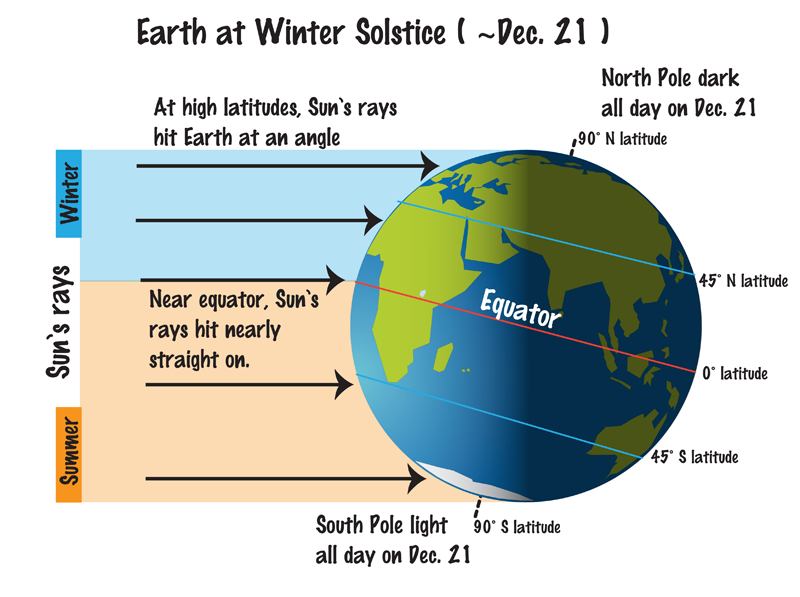
Astronomical winter arrives in Thornton Saturday evening and with the solstice also comes the shortest day of the year.
Winter officially begins at 9:19pm MST on Saturday, December 21, 2019.
The Winter Solstice occurs when the North Pole is tilted at its furthest from the sun – 23.5 degrees away. This results in the shortest day of the year in the Northern Hemisphere.
Here in Denver, with sunrise at 7:17am and sunset at 4:38pm, our day Saturday will be 9 hours, 21 minutes and 16 seconds long.
The following day, Sunday, it will be about a second longer and each day from now through to the Summer Solstice in June will get gradually longer as well.
While we have a short day on the solstice, it is nothing like what will be experienced in the Arctic Circle. Areas north of there to the North Pole will have no direct sunlight at all. Conversely, areas south of the Antarctic Circle toward the South Pole will have 24 hours of daylight and have a midnight sun.
Did you know that there is a difference between the astronomical seasons that we are discussing here and meteorological seasons?
Meteorological seasons differ slightly and are geared toward matching the calendar with the annual temperature cycle. This is done primarily for meteorological observing and forecasting and in many ways it is more logical than the astronomical seasons.
For the Northern Hemisphere, the meteorological spring covers the months of March, April and May. Summer brings the hottest months of the year and so meteorological summer is June, July and August. Meteorological fall then is September, October and November followed by the coldest months of December, January and February as meteorological winter.
For the second month in a row, Mother Nature kept us cold and delivered a healthy dose of snow. Thornton experienced its second coldest November of the past 13 years and the snowiest of the past 13 years.
The month started out chilly but soon saw things stabilize and turn seasonal. Then, the 8th and 9th offered up our two warmest days of the month with readings of 71 and 79 degrees respectively. We quickly chilled out and saw our first snowfall of the month on the 9th although it was minimal.
From the 12th to the 19th, weather was relatively calm and temperatures for the most part warmer than normal.
After that, things went downhill with most of the balance of the month seeing temperatures well below normal. Light snow on the 20th, 21st and 22nd was followed by our most significant storm of the season on the 26th.
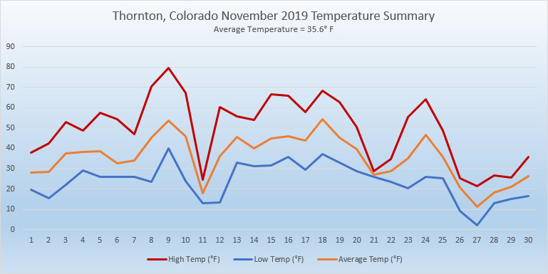
Thornton saw an overall overage temperature for November of 35.6 degrees. This was a good ways below the long term Denver average for the month of 38.3 degrees. Out at Denver International Airport where Denver’s official measurements are taken, the average temperature for the month was 36.2 degrees.
Temperatures in Thornton ranged from a high of 79 degrees on the 9th down to a low of 2 degrees on the 27th. Out at the airport, Denver saw its warmest reading of 77 degrees on the 9th also and its coldest temperature of -2 degrees on the 27th. The high temperature on the 9th was a record high for the date.
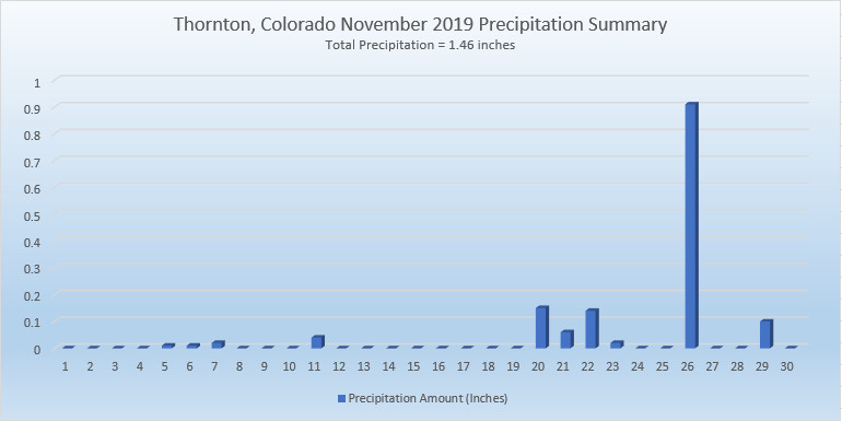
A generous amount of precipitation was received with Thornton recording 1.46 inches of rain and snowmelt. Denver lagged a bit with 1.31 inches. Both readings were well above the long term Denver average of 0.61 inches for November.
In terms of snowfall, the Mile High City averages 8.7 inches in November. Thornton’s reading of 16.7 inches and Denver’s of 13.7 inches easily bested the average.
CLIMATE REPORT
NATIONAL WEATHER SERVICE DENVER/BOULDER CO
905 AM MST SUN DEC 1 2019

...................................

...THE DENVER CO CLIMATE SUMMARY FOR THE MONTH OF NOVEMBER 2019...

CLIMATE NORMAL PERIOD 1981 TO 2010
CLIMATE RECORD PERIOD 1872 TO 2019

WEATHER         OBSERVED          NORMAL  DEPART  LAST YEAR`S
                 VALUE   DATE(S)  VALUE   FROM    VALUE  DATE(S)
                                          NORMAL
................................................................
TEMPERATURE (F)
RECORD
 HIGH              81   11/27/2017
 LOW              -18   11/29/1877
HIGHEST            77   11/09        73       4       65  11/02
LOWEST             -2   11/27        -6       4       10  11/12
AVG. MAXIMUM     49.7              52.1    -2.4     50.6
AVG. MINIMUM     22.7              24.5    -1.8     25.0
MEAN             36.2              38.3    -2.1     37.8
DAYS MAX >= 90      0               0.0     0.0        0
DAYS MAX <= 32      7               2.3     4.7        2
DAYS MIN <= 32     25              23.4     1.6       27
DAYS MIN <= 0       1               0.6     0.4        0

PRECIPITATION (INCHES)
RECORD
 MAXIMUM         3.21   1946
 MINIMUM            T   1899
                        1901
                        1949
TOTALS           1.31              0.61    0.70     0.35
DAILY AVG.       0.04              0.02    0.02     0.01
DAYS >= .01         8               4.7     3.3        6
DAYS >= .10         4               1.6     2.4        1
DAYS >= .50         1               0.0     1.0        0
DAYS >= 1.00        0               0.0     0.0        0
GREATEST
 24 HR. TOTAL    0.80   11/26 TO 11/26           11/11 TO 11/11

SNOWFALL (INCHES)
RECORDS
 TOTAL           13.7               8.7
RECORD NOVEMBER  42.5   1946

DEGREE_DAYS
HEATING TOTAL     860               801      59      808
 SINCE 7/1       1535              1382     153     1373
COOLING TOTAL       0                 0       0        0
 SINCE 1/1        916               769     147     1026

FREEZE DATES
RECORD
 EARLIEST     09/08/1962
 LATEST       06/08/2007
EARLIEST                        10/07
LATEST                          05/05
.................................................................

WIND (MPH)
AVERAGE WIND SPEED              9.3
RESULTANT WIND SPEED/DIRECTION   2/197
HIGHEST WIND SPEED/DIRECTION    37/020    DATE  11/16
HIGHEST GUST SPEED/DIRECTION    48/010    DATE  11/16

SKY COVER
POSSIBLE SUNSHINE (PERCENT)   MM
AVERAGE SKY COVER           0.50
NUMBER OF DAYS FAIR            7
NUMBER OF DAYS PC             18
NUMBER OF DAYS CLOUDY          5

AVERAGE RH (PERCENT)     65

-  INDICATES NEGATIVE NUMBERS.
R  INDICATES RECORD WAS SET OR TIED.
MM INDICATES DATA IS MISSING.
T  INDICATES TRACE AMOUNT.
Weather, natural disasters & climate news and information.


 February in Colorado typically brings to an end an extended period when average temperatures are at their lowest. Winter begins to loosen its grip and temperatures get warmer but precipitation is not a particularly common event during the month.
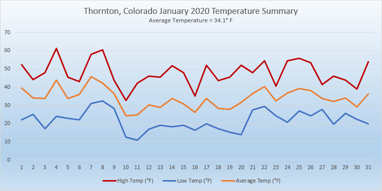
 As we begin the new year the winter chill begins to set in. While January can see its share of extremes, the month historically sees stable temperatures and is usually relatively dry.