August 20 to August 26: This week in Denver weather history
Denver’s weather is not often boring. Lightning, hail, tornadoes and even swarms of grasshoppers have made appearances this week in Denver weather history.
From the National Weather Service:
19-30
In 1875…grasshoppers appeared in great numbers at 10:00 am on the 19th. Thousands landed on the ground. The streets were literally covered with them. Swarms of grasshoppers were seen on each day. All gardens in the city were devastated…and in the countryside the grasshoppers were very destructive to ripened grain. On the 30th the grasshoppers were so numerous as to almost darken the sun.
20
In 1980…winds to 55 to 60 mph were recorded in south Boulder.
In 1982…strong thunderstorm winds blasted the Jefferson County Airport near Broomfield…causing an estimated 3 million dollars in damage. At least 5 hangars and 15 airplanes were damaged…many seriously; one hangar was completely destroyed. Torrential rains accompanied the winds. Heavy rains also dumped on Boulder where 1.65 inches fell in just 15 minutes…causing street flooding. Wind gusts to 72 mph were recorded in Boulder. Over half an inch of rain fell in just 5 minutes in Littleton where two homes were struck by lightning. Lightning also struck a house in Arvada where over an inch of rain sent Ralston Creek over its banks. Strong winds accompanied the storms.
In 1984…slow moving thunderstorms dumped 1.25 inches of rain in Evergreen…causing street flooding. A half inch of rain fell in just 18 minutes in southeast Denver. Littleton and Boulder were also drenched with about an inch of rain. Rainfall totaled 0.92 inch at Stapleton International Airport.
In 2001…severe thunderstorms produced damaging winds and large hail across metro Denver. Hail as large 1 inch in diameter fell in Aurora near Cherry Creek. Strong thunderstorm winds gusting as high as 58 mph blew the roof from a building between Thornton and Denver and toppled several trees in Denver. One tree landed on a mail truck. Other thunderstorm winds were clocked to 60 mph near Parker… 62 mph in Broomfield…and 61 mph at Denver International Airport.
In 2006…a tornado (f0) touched down near Bennett…but caused no reported damage.
In 2013…severe thunderstorms pounded the southern Denver suburbs and other parts of the Front Range. In Jefferson County…water rescues were reported for some people in stranded cars. In the Ken Caryl area…large hail from one inch to 1 3/4 inches in diameter was reported. On West Chatfield Avenue in Jefferson County…hail runoff gathered six inches deep in spots and “hail plows” were sent out to clear some streets. Hail up to one inch in diameter was also reported near Castle Rock.
21
In 1876…heavy thunderstorm rain and hail struck the city. Hail stones as large as partridge eggs accumulated to a depth of 1 1/2 feet over eastern portions of the city. The heavy rainfall flooded streets and gutters. However… No significant damage was reported. Rainfall totaled 0.85 inch in central Denver.
In 1903…a thunderstorm produced west winds sustained to 42 mph with gusts to 48 mph.
In 1957…heavy thunderstorm rainfall and hail over the bear creek basin flooded portions of State Highway 8 in and near Morrison. There was also minor property damage in Morrison.
In 1995…a 68-year-old woman was struck by lightning while standing near a tree in Brighton.
In 2006…a severe thunderstorm produced 7/8 inch diameter hail in Franktown.
NORTH PLATTE, Neb. | This railroad town of 25,000 may be just a speck on flyover country, but for one day next week, North Platte will feel like the center of the universe. Millions of people are expected to gravitate toward rural America to view Monday’s total solar eclipse, a rare celestial event. The path of… Continue reading Solar eclipse to fill small towns across America→
Officials in Sierra Leone’s capital, Freetown, say more than 200 people are dead after a mudslide and heavy flooding. The catastrophe in the early hours of Monday followed hours of heavy rains. Witnesses described a hillside collapse in the Regent area and said roads became “churning rivers of mud.” Sinneh Kamara, a technician at the Connaught… Continue reading Sierra Leone: At Least 200 Dead After Mudslide, Flooding→
Less than half way through the 2017 hurricane season the National Oceanic and Atmospheric Administration has upgraded the chances of an above-normal season in the Atlantic. In May, NOAA had estimated that the chance of an above-normal season was about 45 percent. Now the chance of an above-normal season is set at about 60 percent. This… Continue reading NOAA Upgrades Hurricane Season To Above Normal→
August 13 to August 19: This week in Denver weather history
Severe weather is a fact of life in Colorado during the summer months and while August is historically relatively calm, that isn’t always the case. In our look back at this week in Denver weather history we see the dangers of lightning, incidents of large hail and flooding rains and even a tornado.
From the National Weather Service:
8-13
In 1875…clouds of grasshoppers were seen flying through the air on the prevailing winds during each day.
12-13
In 1975…heavy rains caused flash flooding along the foothills from Denver north. Thunderstorm rainfall totaled 1.56 inches at Stapleton International Airport.
In 2004…a brief cool spell resulted in two daily temperature records. The low temperature of 49 degrees was a record minimum for the 12th…as was the low temperature of 48 degrees on the 13th.
13
In 1959…thunderstorm winds gusted to 53 mph at Stapleton Airport.
In 1983…thunderstorms dumped torrential rain in Northglenn… Thornton…and Broomfield. Northglenn was drenched with 1.72 inches in 30 minutes. Street flooding was widespread. Hail…as large as 3/4 inch in diameter…was reported 7 miles northeast of Boulder along with heavy rain which caused some street flooding.
In 2000…lightning sparked 3 small grass fires near Golden. The fires were quickly contained. Hail as large as 3/4 inch in diameter fell in Castle Rock.
14
In 1960…a bolt of lightning struck a man in Henderson… Causing serious burns.
In 1962…the temperature climbed to a high of 100 degrees at Stapleton Airport.
In 1968…a young man on a golf course in Denver was injured when lightning struck a tree under which he was standing. Lightning caused minor damage to a house in Denver. Heavy thunderstorm rain caused local street flooding. One inch diameter hail fell at Jefferson County Airport near Broomfield.
In 1973…winds as high as 85 mph damaged 20 aircraft at the Arapahoe County airport…now centennial airport.
In 1977…three tornadoes were sighted in Bennett. A man suffered a broken leg when hit by a flying board. He was outside his camper home…which was destroyed. All windows were broken in a near-by farmhouse where some shingles were ripped off and a 2 car garage was knocked down. Several vehicles were damaged and a cat…some rabbits…and chickens were killed. A broken oar from a boat was driven into the side of a house. A mobile home was overturned. One old barn was destroyed. Half a dozen homes and several agricultural buildings were damaged just west of State Highway 79.
In 1978…high winds produced much blowing dust…causing many traffic accidents in the Denver-Boulder area. Winds gusts of 70 to 101 mph were recorded. Northwest winds gusted to 44 mph at Stapleton International Airport.
In 1980…lightning hit two power poles in Littleton…causing 400 dollars in damage. Rainfall of 1.23 inches in a short time caused minor flooding…which included damage to a ground floor apartment and partially submerging a few vehicles in water. Thunderstorm rainfall totaled 0.98 inch at Stapleton International Airport.
In 1983…2.10 inches of rain drenched Golden in an hour with similar amounts in Lakewood and Boulder. Over ten thousand dollars worth of plants were washed away at a nursery in Lakewood.
In 1997…twelve motorists were injured in a multi-car accident when strong microburst winds estimated to 50 mph blew blinding dust across I-70 near Bennett.
In 1998…lightning struck a hydro-electric plant in Nederland… Causing a power outage. Residents in the foothills west of Boulder…including Nederland…Ward…Eldora…Jamestown… And Gold Hill…were without power for about an hour.
In 2006…heavy thunderstorm rainfall near Deckers washed away some the banks along State Highway 67 between Deckers and Westcreek. Several driveways on both sides of the highway were also damaged.
15
In 1899…a thunderstorm produced southwest sustained winds to 43 mph with gusts to 46 mph.
In 1972…a pilot reported a funnel cloud briefly touching the ground in open fields…17 miles east-northeast of Stapleton International Airport.
In 1980…thunderstorm winds gusted to 55 mph in Boulder.
In 1982…brief heavy rain and winds estimated as high as 70 mph occurred in the conifer-Evergreen area. No damage was reported.
In 1990…lightning triggered a small attic fire in a house near Sedalia…20 miles south of Denver. A furious lightning storm caused widespread power outages across southern sections of metro Denver. One lightning bolt knocked out an electrical substation…causing a 90-minute blackout in southeast Denver affecting nearly 10 thousand homes and businesses.
In 2007…severe thunderstorms produced large hail…up to 2 inches in diameter…near larkspur. Extensive damage to vehicles in the area was reported.
In Parker…lightning struck a residence. The ensuing fire damaged the attic and top floor; causing $100000 in property damage.
In 2008…at least three homes were hit by lightning during the early morning hours in Arapahoe County. Lightning also struck two homes in Castle Rock…damaging the roofs.
16
In 1902…a thunderstorm produced west winds sustained to 48 mph with gusts to 60 mph…but only a trace of rain.
In 1952…a thunderstorm wind gust to 50 mph was recorded at Stapleton Airport.
In 1960…lightning struck a warehouse in central Denver… Causing 8 thousand dollars in damage to the building and stored electrical equipment.
In 1975…large hail…1 1/2 to 1 3/4 inches in diameter…fell about 4 miles north of Castle Rock. Hail caused some minor damage in Aurora. A funnel cloud was reported 25 miles east of Denver near Bennett.
In 1981…a tornado touched down briefly in open country just to the east of Aurora. No damage was reported.
In 1982…a thunderstorm wind gust to 61 mph was recorded at Buckley Field in Aurora. At the same time almost an inch of rain flooded and closed streets in south Aurora. A women was hit by lightning just north of Denver. A house in the area was also struck.
In 1985…a thunderstorm produced strong wind gusts over southern metro Denver. One strong wind gust hit Cheery Creek Reservoir…capsizing a boat and drowning a man. The wind gusts…clocked as high as 50 mph…also downed a few trees.
In 1989…1 3/4 inch diameter hail fell at Intercanyon in the foothills of Jefferson County.
In 1990…lightning caused minor damage to a south Aurora home. No injuries were reported.
In 1994…strong thunderstorm winds caused damage in southern weld County near Hudson and Fort Lupton. Two mobile homes were destroyed and a few lost their roofs. Up to 20 downed power poles and the destruction of two 115 thousand-volt towers caused widespread power outages. Thunderstorm gust front winds from the north gusted to 48 mph at Stapleton International Airport.
In 2000…lightning ripped most of the roof from a home in southeast Aurora. The bolt sparked a fire which destroyed the residence. Damage was estimated at 250 thousand dollars.
In 2002…the temperature climbed to a maximum of 100 degrees setting a new record high for the date.
In 2003…a teenager was injured when he was struck by lightning while camping at Herman Lake…13 miles northwest of Georgetown. The boy was knocked unconscious and suffered minor injuries.
In 2013…a dry microburst uprooted 30 to 40 large trees across a 12-block area of the Park Hill neighborhood in east central Denver. Several trees were snapped near the base along with numerous branches…8 to 10 inches in diameter. Power poles and lines were also downed with resulted in outages which affected seven hundred residents. One of the downed trees crushed a car`s hood… narrowly missing the driver. At Denver International Airport…a peak wind gust of 22 mph was observed from the southwest.
August 6 to August 12: This week in Denver weather history
As we get further into the month of August severe weather is less common. It can however still strike as we see in our look at this week in Denver weather history. Everything from torrential rains to massive hail and even a tornado have been reported.
From the National Weather Service:
6
In 1877…a severe rain…hail…and wind storm struck Denver. The storm produced a one minute sustained wind speed of 75 mph. Rainfall totaled 1.00 inch in 25 minutes. The hail storm damaged vegetable gardens in the city.
In 1954…an unconfirmed tornado was reported in Westminster. A funnel cloud was sighted in the area…but it was not certain if it had touched down. No damage was reported.
In 1980…the temperature reached 100 degrees…setting a new record high for the date.
In 1982…3/4 inch diameter hail was reported in north Denver. Heavy rain caused street flooding in central Denver where 4 to 5 feet of water inundated I-25…closing the freeway for a while. Rainfall across metro Denver ranged up to 2.35 inches in just over an hour. An estimated 2000 basements were flooded. Only 0.01 inch of rain fell at Stapleton International Airport.
In 1991…heavy rain caused flooding at the junction of I-25 and I-70. Dime size hail was reported northeast of Boulder near Niwot.
In 1995…microburst winds gusting as high as 58 mph caused minor damage to an apartment complex in Broomfield. Some homes under construction were also damaged when the winds knocked over 2 by 4 wood beams along with some insulation and roofing materials…which broke a few windows. Microburst winds also overturned a camper near Barr Lake.
In 1996…hail ranging in size from 1 to 1 1/2 inches fell near Bennett.
In 2001…3/4 inch hail fell in the foothills near Conifer.
In 2008…a record daily rainfall record was set at Denver International Airport. The record of 1.29 inches in 24 hours broke the previous record of 1.10 inches set in 1929.
7
In 1948…a brief west moving tornado was sighted 3 miles north-northeast of Stapleton Airport. The white funnel silhouetted against a gray cloud background was very narrow…nearly vertical…and estimated at nearly 5 thousand feet high. A dust cloud formed on the ground around the funnel. No damage was reported.
In 1952…a thunderstorm wind gust to 52 mph was recorded at Stapleton Airport.
In 2014…severe thunderstorms produced large hail across western and southern parts of metro Denver. Near Centennial and Golden…hail up to quarter size was reported. Near Bennett…a peak thunderstorm wind gust to 65 mph was also reported. At Denver International Airport…a peak wind gust to 46 mph was recorded.
8
In 1874…swarms of grasshoppers invaded the city. Millions of them were seen cruising through the air. The insects were apparently picked up by a thunderstorm gust front and carried into the city. The grasshoppers had ravaged crops in surrounding counties for the last month.
In 1878…the highest temperature ever recorded in Denver…105 degrees…occurred at 3:20 pm. This temperature was equaled on July 20th in 2005.
In 1969…the temperature reached 100 degrees at Stapleton International Airport.
In 1976…in Thornton…a 13 year old boy riding a bicycle was struck and killed by lightning.
In 2000…lightning struck three homes in central Arapahoe County east of Denver. Damage was estimated at 47 thousand dollars.
In 2003…hail to 1 inch in diameter pelted Denver. Hail to 7/8 inch was measured in Boulder.
In 2008…heavy rain also caused flash flooding over south Denver and its nearby suburbs. Heavy rain…from 2.5 to 4 inches…fell in less than 90 minutes. Firefighters rescued 20 people as the water quickly rose along creeks…flooded roadways…and stranded motorists. Three people had to be rescued along Cherry Creek when the bike path flooded. In Evergreen…a man suffered minor injuries when he was struck by lightning. It entered his finger…traveled down his body… And exited his foot.
In 2013…heavy rain caused localized flash flooding in Aurora. An undergound parking garage at an apartment complex was inundated with 3 to 4 feet of water. Flash flooding forced a road closure at East Mississippi Ave. and Alton St. Also… several people had to be rescued when three vehicles stalled in floodwaters at Alameda Ave. and Havana St. The stationary thunderstorms dumped 2.75 inches of rain in less than 45 minutes. In addition…large hail…up to one inch in diameter… was reported north of Roxbourough State Park. At Denver International Airport…just a trace of rainfall was observed.
8-10
In 1979…heavy thunderstorm rains on each of three consecutive days dumped a total of 2.22 inches of rain at Stapleton International Airport. The heaviest rain… 0.95 inches…fell on the 9th. Small hail to 1/8 inch diameter fell on the 8th.
WASHINGTON, August 7, 2017 – According to the National Center for Public Policy Research Al Gore resides in a 10,070-square-foot Colonial-style home built in 1915 in the posh Belle Meade section of Nashville. According to the U.S. Census Bureau, Belle Meade is the eighth-wealthiest neighborhood in America. The home, on a 2.09-acre lot and that Gore… Continue reading Al Gore’s Belle Meade: A Tennessee energy pit→
Tulsa, Okla., residents woke up to the devastation of an EF2 tornado that hit the town overnight, reports FOX23. 12:50pm – Survey team confirms tornado damage across central Tulsa. EF2 intensity also confirmed. Survey continues. Watch the video — NWS Tulsa (@NWStulsa) August 6, 2017 The tornado hit shortly after 1 AM, destroying multiple businesses. There… Continue reading Images the day after a dangerous Oklahoma tornado show the destruction it left in its wake→
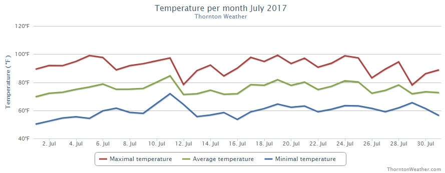
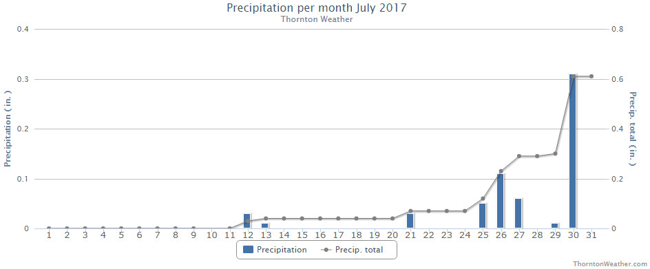
The month of July might have seemed quite hot but in fact mercury readings were right near normal. What likely caused the misconception is the fact that we saw far less than normal rain.
High pressure did dominate for much of the month and while monsoonal flow did bring rain to eastern Colorado, it largely missed our area. The Palmer Divide and southeastern Colorado were beneficiaries for much of the month but for us it wasn’t until the last week that we saw relief.
Thornton’s average temperature for the month came in at 74.1 degrees. This is almost exactly matches Denver’s long-term July average of 74.2 degrees. Out at DIA where the Mile High City’s official temperatures are taken, it shows a far warmer month with an average of 76.4 degrees.
Temperatures here ranged from a maximum of 99.2 degrees on the 19th down to a low of 50.1 degrees on the morning of the 1st. Out at the airport, their highest reading was actually 100 degrees seen on the 6th and again on the 19th. The low out there was 51 degrees on the 1st.
On average Denver receives 2.16 inches of precipitation during July. Both Thornton and Denver fell far short of that mark. We managed to record 0.61 inches in our bucket during the month, more than half of which fell on the second to last day of the month. At DIA, Denver recorded 0.47 inches.
Thornton, Colorado’s July 2017 temperature summary. (ThorntonWeather.com)Thornton, Colorado’s July 2017 precipitation summary. (ThorntonWeather.com)
From the National Weather Service:
CLIMATE REPORT
NATIONAL WEATHER SERVICE DENVER/BOULDER CO
656 AM MDT TUE AUG 1 2017

...................................

...THE DENVER CO CLIMATE SUMMARY FOR THE MONTH OF JULY 2017...

CLIMATE NORMAL PERIOD 1981 TO 2010
CLIMATE RECORD PERIOD 1872 TO 2017

WEATHER         OBSERVED          NORMAL  DEPART  LAST YEAR`S
                 VALUE   DATE(S)  VALUE   FROM    VALUE  DATE(S)
                                          NORMAL
................................................................
TEMPERATURE (F)
RECORD
 HIGH             105   07/20/2005
 LOW               42   07/04/1903
                        07/31/1873
HIGHEST           100   07/19        99      -5      102  07/10
                        07/06
LOWEST             51   07/01        51       9       51  07/12
AVG. MAXIMUM     91.5              89.4     2.1     92.0
AVG. MINIMUM     61.3              58.9     2.4     60.5
MEAN             76.4              74.2     2.2     76.2
DAYS MAX >= 90     20              16.0     4.0       22
DAYS MAX <= 32      0               0.0     0.0        0
DAYS MIN <= 32      0               0.0     0.0        0
DAYS MIN <= 0 0 0.0 0.0 0
PRECIPITATION (INCHES)
RECORD
 MAXIMUM 6.41 1965
 MINIMUM 0.01 1901
TOTALS 0.47 2.16 -1.69 1.07
DAILY AVG. 0.02 0.07 -0.05 0.03
DAYS >= .01         6               8.3    -2.3        6
DAYS >= .10         3               4.3    -1.3        4
DAYS >= .50         0               1.4    -1.4        1
DAYS >= 1.00        0               0.7    -0.7        0
GREATEST
 24 HR. TOTAL    0.15   07/21 TO 07/21           07/01 TO 07/01
                                                          06/30 TO 07/01
                                                          07/01 TO 07/01

SNOWFALL (INCHES)
RECORDS TOTAL      0.0
 TOTALS            0.0 2017         0.0

DEGREE_DAYS
HEATING TOTAL       0                 6      -6        0
 SINCE 7/1          0                 6      -6        0
COOLING TOTAL     360               289      71      356
 SINCE 1/1        533               444      89      544

FREEZE DATES
RECORD
 EARLIEST     09/08/1962
 LATEST       06/08/2007
EARLIEST                        10/07
LATEST                          05/05
..................................................

WIND (MPH)
AVERAGE WIND SPEED              9.6
RESULTANT WIND SPEED/DIRECTION   3/204
HIGHEST WIND SPEED/DIRECTION    45/120    DATE  07/15
HIGHEST GUST SPEED/DIRECTION    53/120    DATE  07/15

SKY COVER
POSSIBLE SUNSHINE (PERCENT)   MM
AVERAGE SKY COVER           0.50
NUMBER OF DAYS FAIR            6
NUMBER OF DAYS PC             21
NUMBER OF DAYS CLOUDY          4

AVERAGE RH (PERCENT)     45

WEATHER CONDITIONS. NUMBER OF DAYS WITH
THUNDERSTORM              9     MIXED PRECIP               0
HEAVY RAIN                0     RAIN                       3
LIGHT RAIN                9     FREEZING RAIN              0
LT FREEZING RAIN          0     HAIL                       0
HEAVY SNOW                0     SNOW                       0
LIGHT SNOW                0     SLEET                      0
FOG                       3     FOG W/VIS <= 1/4 MILE      1
HAZE                      3

-  INDICATES NEGATIVE NUMBERS.
R  INDICATES RECORD WAS SET OR TIED.
MM INDICATES DATA IS MISSING.
T  INDICATES TRACE AMOUNT.
As summer vacations wind down and families prepare to send their kids back to school in August, Colorado weather also starts to settle down. The chances for severe weather decrease markedly during August and by the end of the month daytime temperatures are dropping quite a bit as well.