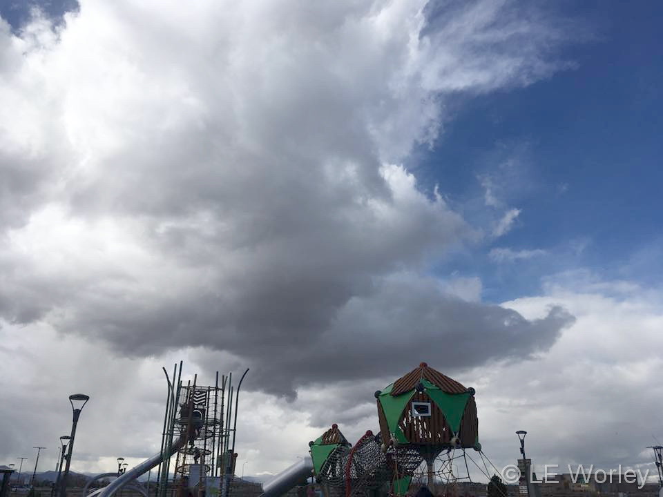
Cool clouds over Thornton on an unsettled day. (LE Worley)
Typically November is a quiet weather month with plenty of nice, fall days but it can also turn wet with healthy doses of snow and moisture. The wide variety of conditions can create picturesque scenes ranging from blue skies and snow-capped mountains to a wintry wonderland in the metro area.
November is the second snowiest month of the year so winter conditions are not unusual. Typically though, these bouts of cold are short-lived and normal daytime conditions are pleasant.
Outdoor activities continue to be quite popular during the month. The cooling temperatures do oftentimes lead to an increase in wildlife activity.
All of the above help lead to a month in which a wide variety of scenes, flora and fauna can be captured.
Slideshow updated November 28, 2018
To learn more about how to send your photo to us for inclusion in the slideshow, see below the slideshow.
Showcasing images captured by ThorntonWeather.com readers as well as some of our own, our monthly slideshow covers the entire gamut of weather-related imagery.
Sunsets, sunrises, wildlife and of course every type of weather condition are vividly depicted in images captured from yours and our cameras.
[flickr_set id=”72157699958645692″]
What is missing in the slideshow above? Your photo!
Our monthly photo slideshow is going to feature images that we have taken but more importantly images that you have captured. The photos can be of anything even remotely weather-related.
Landscapes, current conditions, wildlife, pets, kids. Whimsical, newsy, artsy. Taken at the zoo, some other area attraction, a local park, a national park or your backyard. You name it, we want to see and share it!
Images can be taken in Thornton, Denver or anywhere across the extraordinary Centennial State. We’ll even take some from out of state if we can tie it to Colorado somehow.
We’ll keep the criteria very open to interpretation with just about any image eligible to be shown in our slideshows.
What do you win for having your image in our slideshow? We are just a ‘mom and pop’ outfit and make no money from our site so we really don’t have the means to provide prizes. However you will have our undying gratitude and the satisfaction that your images are shared on the most popular website in Thornton.
To share you images with us and get them included in the slideshow just email them to us or share them with ThorntonWeather.com on any of the various social media outlets. Links are provided below.
November 25 to December 1: This week in Denver weather history
From powerful, damaging wind to snowstorms that snarled Thanksgiving holiday traffic, this week in Denver weather history has been an eventful one.
From the National Weather Service:
21-25
In 1952…snowfall of 6.2 inches was measured at Stapleton Airport where northeast winds gusted to 17 mph on the 21st.
24-25
In 1908…heavy snowfall totaled 7.0 inches over downtown Denver overnight. North winds were sustained to 15 mph.
In 1930 strong winds raked the Front Range eastern foothills. Winds gusted to 40 mph at Valmont just east of Boulder where minor damage occurred.
In 1970…strong Chinook winds warmed Boulder. At the National Center for Atmospheric Research in Boulder…wind gusts reached 97 mph…while in downtown Boulder winds peaked to 69 mph. Some minor damage occurred. Northwest winds gusted to 39 mph at Stapleton International Airport…and the high temperature warmed to 76 degrees on the 25th…setting a new record maximum for the date.
25
In 1877…northwest winds were sustained to 50 mph.
In 1902…northwest winds were sustained to 45 mph with gusts to 48 mph. The strong apparent bora winds warmed the temperature to a high of only 45 degrees.
In 1943…snowfall of 4.0 inches was the only measurable snow of the month. North winds were sustained to 17 mph.
In 1958…strong pre-frontal Chinook winds struck Boulder and the eastern foothills. A wind gust to 100 mph was recorded northwest of Denver. A gust to 88 mph occurred at Rocky Flats south of Boulder. The windstorm caused considerable structural damage to residential sections of north metro Denver.
In 1959…strong winds raked the eastern foothills including Boulder and Eldorado Springs. Wind gusts to 100 mph were estimated at the Matterhorn Restaurant located atop Rocky Flats south of Boulder.
In 1993…a wind gust to 99 mph was recorded atop Squaw Mountain near Idaho Springs.
In 1998…strong winds developed over portions of the Front Range foothills for a brief time following the passage of a weak upper level disturbance. A wind gust to 71 mph was measured atop Blue Mountain near Coal Creek Canyon.
In 1999…strong Chinook winds developed in and near the foothills. Peak wind reports included 100 mph at the Eldora Ski Resort and 77 mph at the National Center for Atmospheric Research mesa lab above Boulder. West winds gusted to 38 mph at Denver International Airport.
In 2010…high winds developed in the foothills of Boulder County. A gust to 75 mph occurred 5 miles northwest of Boulder with a gust to 72 mph at the National Center for Atmospheric Research Mesa Lab above Boulder. West winds gusted to 24 mph at Denver International Airport.
25-26
In 1887…snowfall totaled 2.9 inches in the city. This was the only measurable snow of the month. Northeast winds were sustained to 18 mph on the 26th when the temperature dipped to 12 degrees below zero.
In 1959…a sharp cold front produced a northwest wind gust to 51 mph…followed by snow and falling temperatures from a high of 60 degrees to a low of 23 degrees at midnight on the 25th. Snowfall totaled 4.4 inches at Stapleton Airport before ending early on the 26th.
In 1972…winds gusted to 104 mph at the Rocky Flats plant south of Boulder. Gusts to 70 mph were recorded at the National Bureau of Standards in Boulder…while in downtown Boulder winds peaked to 68 mph. Some damage was reported. Northwest winds gusted to 47 mph at Stapleton International Airport on the 26th.
In 1984…blowing snow closed I-70 east of Denver…stranding over a thousand travelers in Limon. Denver received only 2.3 inches of snowfall. North winds gusted to 31 mph at Stapleton International Airport.
In 1999…strong Chinook winds redeveloped overnight in and near the foothills. Peak wind gusts included 72 mph atop Blue Mountain near Wondervu and at the National Center for Atmospheric Research mesa lab above Boulder.
25-27
In 1978…heavy snowfall of 6.0 inches was measured at Stapleton International Airport where north winds gusted to 20 mph. Most of the snow…4.8 inches…fell on the 25th. The greatest amount of snow measured on the ground was 5 inches due to settling and melting.
25-28
In 1952…the average coldest 4-day period in November in the previous 81 years of record occurred. Maximum temperatures of 19…15…21…and 25 degrees were recorded. Minimum temperatures were below zero each day with readings of 7 below…6 below…5 below…and 6 below.
25-29
In 1985…dense fog with visibilities as low as 1/8 mile occurred on five consecutive days at Stapleton International Airport. The fog was at times accompanied by light snow… Light freezing drizzle…or ice crystals. Fog occurred all day on both the 26th and 29th.
26
In 1873…west winds increased to a violent gale at 3:00 am and reached a maximum sustained velocity of 56 mph at 3:15 am. The winds continued with a velocity of not less than 40 mph until 6:00 am. Winds continued brisk for the remainder of the day. The strong winds caused damage to houses and buildings in the city. Temperatures were in the 50’s through early afternoon with a recorded high of 59 degrees. Winds also blew strongly in Boulder and caused 300 dollars in damage.
In 1911…post-frontal northeast winds were sustained to 43 mph with gusts as high as 52 mph. Snowfall was only 0.5 inch.
In 1965…post-frontal snowfall totaled 5.5 inches at Stapleton International Airport where strong west winds gusted to 39 mph during the afternoon.
In 1976…2 to 4 inches of snow with an arctic cold front produced near zero visibility at times in blowing snow… Causing multiple automobile accidents in metro Denver. Snowfall totaled 3.5 inches at Stapleton International Airport where north winds gusted to 39 mph. Temperatures hovered in the teens and lower 20’s most of the day dipping to 7 degrees by midnight.
In 1977 a strong wind storm raked metro Denver. High winds blew windows from office towers in Denver and Boulder. Thirteen people were injured in Boulder due to flying debris. Wind gusts to 119 mph were clocked on Davidson Mesa southeast of Boulder…with 109 mph in downtown Boulder. Six airplanes were damaged at Jefferson County Airport near Broomfield. Winds to 90 mph were reported in Lakewood. Glass was blown out of several vehicles in Wheat Ridge…and roofs were blown off 4 houses in Arvada. Several houses under construction collapsed across metro Denver. Winds to 75 mph were reported at the Denver Federal Center with 90 mph at Rocky Flats. West winds gusted to 51 mph at Stapleton International Airport. Total insured damage from the wind storm was 2.2 million dollars.
In 1987…a Thanksgiving snowstorm brought 5 inches of snow to metro Denver and 6 inches to the foothills. At Stapleton International Airport…snowfall totaled 5.0 inches…north winds gusted to 22 mph…and temperatures hovered in the upper 20’s most of the day.
In 1991…strong winds were recorded in and near the eastern foothills. Winds at Rollinsville were clocked to 70 mph with 45 mph recorded in Boulder and 51 mph at the U.S. Atomic Energy Commission Rocky Flats plant. West winds gusted to only 28 mph at Stapleton International Airport.
Weather Geek Stuff is a great place to shop for gifts for weather enthusiasts, weather geeks and weather lovers.
Not everyone gets excited about blizzards, tornadoes, hurricanes and other types of extreme weather but many folks out there are passionate about Mother Nature. Weather Geek Stuff is an online shop just for those whose hearts race with the thrill of severe weather and they are offering special deals through the holiday season.
Weather Geek Stuff is an online store that provides a host of clothing items and novelties just for weather buffs. From the store’s custom ‘Weather Geek’ and ‘Weather Diva’ logoed merchandise to items imprinted with amusing weather warnings signs as well as Skywarn storm spotter logos, there is something there sure to please any weather lover.
Weather Geek Stuff’s merchandise was shown on the Weather Channel as a recommended gift so you know the quality is good. Stu Ostro, Weather Channel’s Senior Director of Weather Communications even sports a ‘Weather Geek’ t-shirt on his Twitter profile.
Kids and dogs aren’t left out of the weather fun either. There is a wide variety of clothing items sized just right for the little ones from babies to bigger kids. Canine companions as well can get shirts and bowls emblazoned with a weather-related logo.
The selection goes far beyond clothing too. Water bottles, clocks, mugs, bags and other novelties are part of the store’s offerings. For the tech types, cases for iPhones and iPads are available. Recently added products include laptop skins, clipboards and throw blankets.
Weather Geek Stuff is owned and operated by the same folks that run ThorntonWeather.com. We provide ThorntonWeather.com as a no-cost service to the community and use the minimal amount of money made from Weather Geek Stuff to support the costs of running this website and the associated equipment. So remember, if you have a weather buff on your shopping list, by buying from Weather Geek Stuff you are supporting ThorntonWeather.com! You can also donate directly to fund the site here.
November 18 to November 24: This week in Denver weather history
Powerful winds and heavy snow make up the majority of significant weather events in our look back at this week in Denver weather history.
From the National Weather Service:
14-18
In 1964…the first measurable snowfall of the season totaled 6.0 inches at Stapleton International Airport where northeast winds gusted to 32 mph on the 14th. Most of the snow…4.2 inches…fell on the 14th. This was the only measurable snow of the month.
16-18
In 1921…heavy snowfall totaled 6.5 inches over downtown Denver. This was the only measurable snow of the month. East winds were sustained to 14 mph on the 17th.
17-18
In 1869…the heaviest wind storm in 5 or 6 years raked the eastern foothills including Boulder…Denver…Georgetown… And Golden. Some hundreds of dollars in damage occurred in Boulder.
18
In 1872…fresh west winds contributed to the relative humidity dipping to zero at 2:43 pm. The maximum temperature was 54 degrees.
In 1907…heavy snowfall totaled 6.0 inches over downtown Denver. Snow fell all day. North winds were sustained to 19 mph.
In 1915…northwest winds were sustained to 42 mph with gusts as high as 48 mph. It was windy most of the day.
In 1996…high winds struck the foothills west of Denver. Wind gusts ranged from 70 to 75 mph. A few power lines were downed…but no major outages were reported.
In 1998…strong downslope winds developed during the morning. Wind gusts reached a peak of 72 mph at Jefferson County Airport near Broomfield. West winds gusted to 41 mph at Denver International Airport.
In 1999…high winds developed in and near the Front Range foothills. The strong winds downed power lines…which sparked several small brush fires. In Broomfield… Scaffolding was damaged at the Wadsworth Recreation Center…while flying rocks broke several windows at a local bank building. Peak wind gusts included: 91 mph atop Blue Mountain near Wondervu…88 mph atop the Gamow Tower on the University of Colorado campus in Boulder… 83 mph at Jefferson County Airport…81 mph at the National Center for Atmospheric Research mesa lab above Boulder…and 80 mph at Wondervu. West-northwest winds gusted to 48 mph at Denver International Airport.
18-19
In 1975…snowfall totaled only 5.5 inches and north winds gusted to 35 mph causing some blowing snow at Stapleton International Airport…while a major blizzard struck southeastern Colorado.
In 1985…4 to 7 inches of snow fell across metro Denver. Snowfall totaled 4.4 inches at Stapleton International Airport where north winds gusted to 23 mph.
In 1991…another strong winter storm produced heavy snow over metro Denver. Snowfall totaled 9.5 inches at Stapleton International Airport with 9 inches at Parker… And 8 inches in southeast Denver…Morrison…and Wheat Ridge. This second storm brought the 5 day (15th-19th) snowfall total at Stapleton International Airport to 21.1 inches. The greatest depth of snow on the ground was 13 inches on the morning of the 19th. The adverse effects of the two storms were diminished by the lack of significant winds.
18-20
In 1930…a major storm dumped a total of 13.6 inches of snowfall over downtown Denver. Most of the snow…9.4 inches…fell on the 19th when north winds were sustained to 23 mph. This was the only measurable snow of the month. Temperatures hovered in the 20’s and lower 30’s.
In 1956…an intense winter storm dumped 12.8 inches of snowfall on metro Denver. Strong north-northeast winds gusting to 33 mph at Stapleton Airport frequently reduced the visibility to 1/2 mile in snow and blowing snow on the 19th. Most of the snowfall…10.7 inches…occurred on the 19th.
November 11 to November 17: This week in Denver weather history
Two conditions seem to dominate Denver weather this time of year – snow and wind. Both of those make numerous appearances in our look back at this week in Denver weather history.
From the National Weather Service:
10-11
In 1911…a strong cold front produced snow and a cold wave. The temperature dropped 68 degrees from a high of 66 degrees at 12:40 pm on the 10th to a low of 2 degrees below zero at 7:15 am on the 11th. The low temperature of 23 degrees at midnight on the 10th was also the high temperature on the 11th. Northeast winds were sustained to 42 mph with gusts to 51 mph. Snowfall was only 2.5 inches.
In 1982…up to 4 inches of snow fell over the higher terrain between Denver and Colorado springs. Winds gusted to 50 mph along the foothills. Rainfall totaled 0.27 inch with only 0.1 inch of snow on the 11th at Stapleton International Airport where north winds gusted to 39 mph. Dense fog with visibilities as low as zero persisted all day on the 10th.
10-14
In 2014…an Arctic cold front on the 10th…associated with a strong storm system over the northern Rockies blasted into northeast Colorado. The temperature in Denver plummeted from the high of 64 degrees at 4:37 pm to 34 degrees by 5:53 pm. The temperatures continued to fall and dropped into the teens by early evening. The Arctic airmass remained entrenched over the region through the morning of the 14th…with the high temperatures failing to reach the teens from the 11th through the 13th. This was the first time since records have been taken in Denver…dating back to 1872…that there were three consecutive days with the maximum temperatures remained below 20 degrees in the month of November. In addition to the frigid temperatures…0.1 inch of snowfall was observed on 11th at Denver International Airport…which marked the first measureable snowfall for the season. An additional 2.2 inches of snowfall was measured on the 12th. Several temperature records were broken. A record low max of 16 degrees on the 11th broke the previous record of 19 set back in 1916. A record low max of 6 degrees on the 12th broke the previous record of 9 degrees…also set in 1916. The record low of -13 on the 12th…shattered the previous record of -4 degrees set back in 1872. Even more impressive…the record low of -14 degrees on the 13th broke the previous record of -3 degrees set back in 1916. The sudden drop in temperatures on the 10th…followed by several days of sub-freezing temperatures chilled trees to the core. The record drop in temperatures…preceded by mild fall temperatures…damaged or killed scores of trees across the Urban Corridor and Northeast Plains. At the time…the trees were not finished with the hardening process that enables them to withstand winter weather. Many were instantly flash-frozen…and some would not show signs of damage until spring of 2015. Of the 2.2 million trees in the city of Denver alone…tens of thousands were killed from the November frost. Denver estimated a citywide loss of more than 10 million dollars.
11
In 1901…a trace of rain fell in the morning…and a trace of snow fell in the afternoon. This was the only snowfall and precipitation for the month…ranking it the driest November on record…along with November of 1899 and 1949. The month also ranks as the second least snowiest November…along with Novembers in other years.
In 1903…northwest winds sustained to 45 mph with gusts to 56 mph warmed the temperature to a high of 56 degrees.
In 1912…rain changed to snow…which became heavy…and totaled 6.5 inches over downtown Denver. Precipitation was 1.02 inches…the greatest calendar day precipitation ever recorded in November. Northeast winds were sustained to 27 mph with gusts to 29 mph.
In 1919…light snow fell from an apparent clear sky during the early afternoon. The first snow was observed at about 12:40 pm and continued at least 30 minutes before clouds could be seen forming…followed by the sky becoming totally cloudy. During this time the temperature fell from 50 degrees at noon to only 18 degrees at 100 pm and plunged to 6 degrees at 5:45 pm. A low temperature of 2 degrees was recorded overnight. Northeast winds were sustained to 33 mph with gusts to 36 mph between noon and 1:00 pm behind an apparent arctic cold front. Snowfall was only 0.1 inch.
In 1949…north winds gusted to 50 mph at Stapleton Airport. A trace of rain fell. Another trace of rain on the 15th was the only precipitation of the month…making the month one of the driest Novembers on record and the least snowiest with no snow. This was the first November since 1882 without snow.
In 1959…strong northwest winds struck Boulder and the foothills causing some damage. West winds gusted to 37 mph at Stapleton Airport.
In 1995…strong downslope winds gusting to 84 mph blew out a few car windows in Boulder County. Winds gusted to 69 mph at Golden…Lakewood…and Table Mesa in Boulder. West-northwest winds gusted to 43 mph at Denver International Airport.
In 2000…heavy snow occurred in the foothills southwest of Denver and over Monument Ridge south of Denver. Snowfall totals included: 6.5 inches near Parker… 6 inches near Bergen Park…5 inches at Genesee and near Sedalia…and 4 inches at Coal Creek Canyon and St. Mary’s glacier. Snowfall totaled 1.6 inches at the site of the former Stapleton International Airport.
In 2003…strong downslope winds developed along the Front Range. Peak wind reports included 91 mph atop Blue Mountain near Wondervu and 75 mph in Boulder. Damaging winds downed power lines in Boulder County. North of Golden…a semi-truck was blown over by the winds near the intersection of State Highways 72 and 93 atop Rocky Flats. At the same location…blowing rocks shattered several car windows at an RTD Park and Ride. West winds gusted to 40 mph at Denver International Airport.
11-12
In 1922…a major storm dumped 14.1 inches of snowfall over downtown Denver. The most snow on the ground was 10.5 inches at 6:00 pm on the 12th. North winds were sustained to 21 mph on the 11th. Temperatures were generally in the teens and 20’s.
In 1964…strong winds in Boulder caused power outages and minor damage. Winds gusted to 42 mph in downtown Boulder. At Stapleton International Airport west winds gusted to 36 mph on the 11th and 35 mph on the 12th.
In 1976…snow and freezing drizzle caused icing on bridges… Overpasses and some main roads. The elevated portion of I-70 was closed for a time during the afternoon of the 11th. Snowfall totaled only 0.8 inch at Stapleton International Airport…where northeast winds gusted to 20 mph on the 11th.
In 1989…the temperature climbed to a maximum of 76 degrees on both days…setting new record highs for each day.
In 1995…hurricane force downslope winds whipped across the Front Range foothills overnight. The National Center for Atmospheric Research in Boulder registered a peak wind gust to 124 mph with several more wind gusts over 100 mph. Utility poles and power lines were downed…leaving several hundred homes in Boulder without power. Windows were blown out of cars in Boulder. Other reports of strong wind gusts included: 108 mph atop Squaw Mountain west of Denver…104 mph at Table Mesa in Boulder…99 mph at Golden Gate Canyon… 85 mph at the Rocky Flats Environmental Technology site… 69 mph at Jefferson County Airport near Broomfield…and 62 mph in Lakewood. West-northwest wind gusts to 40 mph were recorded at Denver International Airport on the 12th.
November 4 to November 10: This week in Denver weather history
Our look back at this week in Denver weather history is shorter than what we often see which shows the normally quiet weather we see in November. However there are still significant weather events in the past, most of which involved heavy snow and powerful winds.
From the National Weather Service:
2-5
In 1946…a major snow storm dumped 30.4 inches of heavy snowfall downtown and 31.0 inches at Stapleton Airport. The winter storm closed schools and disrupted all forms of transportation in the city. The greatest depth of snow on the ground was 28 inches at the airport. The duration of the snowfall…from 4:22 am on the 2nd to 3:08 am on the 5th… A total of 70 hours and 46 minutes…is the second longest period of continuous precipitation on record and the second heaviest snowfall of record at the time in Denver. The 17.7 inches of snowfall on the 2nd and 3rd was the greatest 24- hour snowfall ever recorded during the month of November. Buses and street cars had a difficult time…and many cars were abandoned along roadsides and streets for several days. Secondary roads in rural areas were blocked for 2 to 3 weeks. Several buildings in the city collapsed or were damaged from the weight of the heavy snow. Football games were canceled. Livestock losses were high over eastern Colorado. The precipitation from this storm alone exceeded the greatest amount ever recorded in Denver during the entire month of November previously. The precipitation recorded downtown was 2.03 inches…and the previous record for the entire month of November was 1.95 inches in 1922. North winds were sustained to 26 mph on the 2nd.
3-4
In 1994…a fast moving snow storm dumped 8 to 9 inches of snow on Boulder…Broomfield…and Lafayette. Snowfall totaled only 1.8 inches at Stapleton International Airport where on the 3rd east winds gusted to 20 mph and some freezing drizzle fell.
4
In 1940…a trace of snow fell in downtown Denver. This marked the start of the shortest snow season on record… 167 days…through April 19…1941…when 0.4 inch of snow fell.
In 1959…high winds caused damage in many areas of the eastern plains.
In Denver…winds averaged 40 mph with gusts to 70 mph. Some damage was reported to utility lines…signs…and vehicles. Northeast winds were sustained to 30 mph at Stapleton Airport.
4-5
In 1933…the first measurable snow of the season totaled only 2.5 inches. This was the only measurable snow of the month. Northwest winds were sustained to 27 mph on the 4th.
In 1951…heavy snowfall of 5.7 inches was measured at Stapleton Airport where northwest winds gusted to 32 mph.
5
In 1896…west Chinook winds sustained to 44 mph with gusts to 46 mph warmed the temperature to a high of 56 degrees in the city.
In 1919…a rare November thunderstorm produced a mixture of rain and snow during the evening. Precipitation totaled only 0.14 inch with only a trace of snow. Northeast winds were sustained to 39 mph with gusts to 44 mph.
In 1948…a west-northwest wind gust to 50 mph was recorded at Stapleton Airport.
In 1994…winds gusted to 76 mph on the summit of Squaw Mountain…5 miles south of Idaho Springs.
In 2000…snow fell in the foothills west of Denver and across the southern suburbs. Snow totals included 6 inches near Evergreen…11 miles southwest of Morrison… And 7 miles south of tiny town and 5 inches in Aurora and Parker. Snowfall totaled 5.5 inches at the site of the former Stapleton International Airport. Northeast winds gusted to 26 mph at Denver International Airport where the visibility was reduced to 1/4 mile in heavy snow at times.
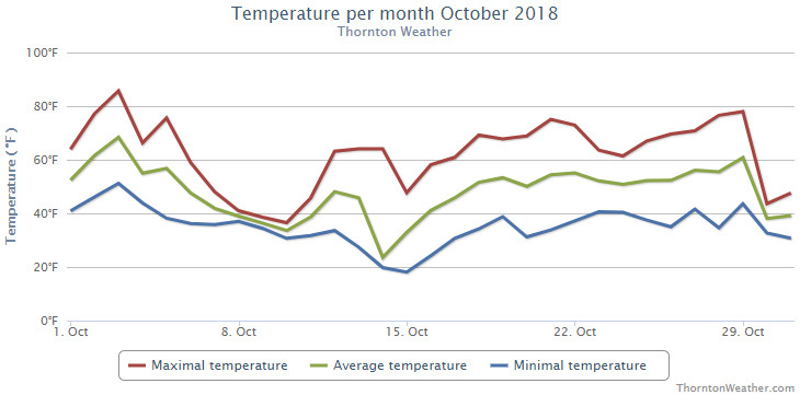
Fall arrived in earnest during the month of October 2018 as temperatures cooled considerably and we saw our first snowfall of the season.
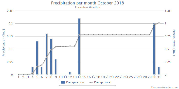
The first two weeks of the month were notable for seeing 12 of 17 days with below normal temperatures. Five days in a row with measurable rain came from the 4th to the 9th and then on the 14th we saw that first snowfall.
The latter half of the month warmed up with above normal mercury readings being seen on all but the last two days of the October. That same stretch of mild days also was one in which we saw no precipitation.
While the overall warm end of the month helped, we still saw overall monthly temperature readings well below normal.
Thornton’s average monthly temperature came in at 47.0 degrees. This is in comparison to Denver’s long term October average of 50.9 degrees, a near 4 degree difference. Out at Denver International Airport where the Mile High City’s official readings are taken, it was a bit warmer with an average for the month of 49.2 degrees.
Here, we ranged from a high of 85.7 degrees on the 3rd down to a low of 18.1 degrees on the morning of the 15th. Denver saw a max of 86 degrees and a low of 18 degrees, each on the same days as our max and min.
Denver set two temperature records during the month. The high temperature of only 27 degrees on the 14th set a new record low maximum for the date. This easily bested the old record of 36 degrees set in 1969. A record low temperature reading of 18 degrees on the 15th topped the previous record low for the date of 20 degrees set in 1970.
In terms of precipitation, Thornton recorded 1.01 inches between rain and snow melt. Denver was very similar with a total of 0.99 inches. Both measurements were close to the long term Denver average of 1.02 inches for the month.
Thornton saw a relatively minimal 2.8 inches of snowfall, all on the 14th. Denver recorded a bit more of the white stuff with 3.2 inches. Both were short of the October average of 4.0 inches.
Thornton, Colorado’s October 2018 temperature summary. (ThorntonWeather.com)Thornton, Colorado’s October 2018 precipitation summary. (ThorntonWeather.com)
...THE DENVER CO CLIMATE SUMMARY FOR THE MONTH OF OCTOBER 2018...

CLIMATE NORMAL PERIOD 1981 TO 2010
CLIMATE RECORD PERIOD 1872 TO 2018

WEATHER         OBSERVED          NORMAL  DEPART  LAST YEAR`S
                 VALUE   DATE(S)  VALUE   FROM    VALUE  DATE(S)
                                          NORMAL
................................................................
TEMPERATURE (F)
RECORD
 HIGH              90   10/01/1892
 LOW               -2   10/29/1917
HIGHEST            86   10/03        83       3       84  10/25
LOWEST             18   10/15        22      -4       13  10/27
AVG. MAXIMUM     61.6              65.3    -3.7     64.5
AVG. MINIMUM     36.8              36.6     0.2     35.7
MEAN             49.2              50.9    -1.7     50.1
DAYS MAX >= 90      0               0.0     0.0        0
DAYS MAX <= 32      1               0.4     0.6        0
DAYS MIN <= 32      7               8.5    -1.5       11
DAYS MIN <= 0       0               0.0     0.0        0

PRECIPITATION (INCHES)
RECORD
 MAXIMUM         4.17   1969
 MINIMUM            T   1934
TOTALS           0.99              1.02   -0.03     0.96
DAILY AVG.       0.03              0.03    0.00     0.03
DAYS >= .01         9               5.3     3.7        5
DAYS >= .10         3               2.4     0.6        4
DAYS >= .50         0               0.5    -0.5        0
DAYS >= 1.00        0               0.1    -0.1        0
GREATEST
 24 HR. TOTAL    0.31   10/07 TO 10/07           10/09 TO 10/09

SNOWFALL (INCHES)
RECORDS
TOTAL             3.2               4.0
RECORD NOVEMBER  38.9  1969

DEGREE_DAYS
HEATING TOTAL     487               440      47      455
 SINCE 7/1        565               581     -16      585
COOLING TOTAL       4                 5      -1        1
 SINCE 1/1       1026               769     257      881

FREEZE DATES
RECORD
 EARLIEST     09/08/1962
 LATEST       06/08/2007
EARLIEST      10/10             10/07
LATEST                          05/05
.................................................................

WIND (MPH)
AVERAGE WIND SPEED              9.7
RESULTANT WIND SPEED/DIRECTION   2/186
HIGHEST WIND SPEED/DIRECTION    39/360    DATE  10/29
HIGHEST GUST SPEED/DIRECTION    49/360    DATE  10/29

SKY COVER
POSSIBLE SUNSHINE (PERCENT)   MM
AVERAGE SKY COVER           0.60
NUMBER OF DAYS FAIR            7
NUMBER OF DAYS PC             16
NUMBER OF DAYS CLOUDY          8

AVERAGE RH (PERCENT)     59

WEATHER CONDITIONS. NUMBER OF DAYS WITH
THUNDERSTORMS             5      MIXED PRECIP       2
HEAVY RAIN                0      RAIN               3
LIGHT RAIN               12      FREEZING RAIN      0
LIGHT FREEZING RAIN       0      HAIL               0
HEAVY SNOW                0      SNOW               3
LIGHT SNOW                6      SLEET              0
FOG                      11      DENSE FOG          4
HAZE                      2

-  INDICATES NEGATIVE NUMBERS.
R  INDICATES RECORD WAS SET OR TIED.
MM INDICATES DATA IS MISSING.
T  INDICATES TRACE AMOUNT.
The weather during the month of November in Denver metro area can offer just about anything. While it is normally a quiet month, it can be prone to extremes.
November has historically been one of Denver’s snowiest months and major snowstorms are not entirely uncommon. However conditions can also be quite dry.
Temperatures during the month continue to cool as we get closer to winter and by the end of the month the low temperatures routinely dip to 20 degrees or below. At times it can in fact bring conditions more like what we see in January.
The United States returns to Standard Time at 2:00am Sunday as Daylight Saving Time comes to an end.
The biannual ritual of changing our clocks to adjust for Daylight Saving Time occurs this weekend, providing yet another signal of the changing of seasons. The United States will ‘fall back’ one hour at 2:00am Sunday morning as we return to Standard Time.
The ritual of changing our clocks twice a year can be met with some resistance as some people struggle to adjust their body’s internal clock. Others actually like the return to standard time as they get to enjoy an extra hour of sleep.
The time change definitely has big effects on the dawning of daylight and how early it gets dark in the evening.
Sunrise on Saturday occurs at 7:30am but on Sunday it will be at 6:32am. Similarly, sunset will occur at 5:55pm on Saturday but on Sunday the sun will disappear over the horizon at 4:54pm.
For many this means that when they get home from work it will now be dark and outdoor activities will be significantly curtailed as a result.
Arizona and Hawaii are the only states that do not observe Daylight Saving Time and remain on Standard Time year round. The U.S. territories of Puerto Rico, American Samoa, Guam, Northern Mariana Islands, and the United States Virgin Islands also do not observe the event.
It won’t be all that long though before Daylight Saving Time returns. On March 11, 2018 we will ‘spring forward.’
Daylight Saving Time Schedule
The mandated beginning and end of Daylight Saving Time has changed in the United States over the years.
The most recent schedule was set by the Energy Policy Act of 2005 and took effect in 2007. We now ‘spring forward’ to begin Daylight Saving Time on the second Sunday in March and ‘fall back’ with the return to Standard Time on the first Sunday in November. Daylight Savings Time Schedule
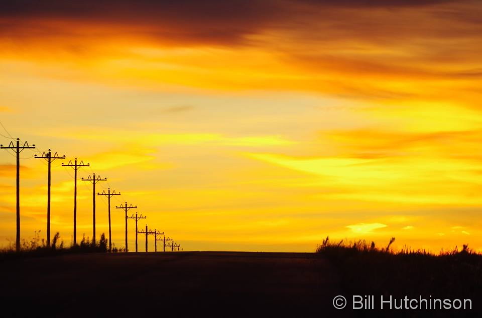
A gorgeous sunrise as seen at the Rocky Mountain Arsenal kicks off the second day of the month. (Bill Hutchinson)
October in Thornton can bring a wide variety of weather conditions, perfect for the photographer in all of us.
The month brings the changing of the colors at Colorado’s lower elevations and it is also is typically when we see our first freeze and first snow.
Couple those facts with our usual widely varying landscapes and wildlife and we have a month that is sure to bring in plenty of photo opportunities.
Slideshow updated October 31, 2018
To learn more about how to send your photo to us for inclusion in the slideshow, see below the slideshow.
Showcasing images captured by ThorntonWeather.com readers as well as some of our own, our monthly slideshow covers the entire gamut of weather-related imagery.
Sunsets, sunrises, wildlife and of course every type of weather condition are vividly depicted in images captured from yours and our cameras.
[flickr_set id=”72157702277411875″]
What is missing in the slideshow above? Your photo!
Our monthly photo slideshow is going to feature images that we have taken but more importantly images that you have captured. The photos can be of anything even remotely weather-related.
Landscapes, current conditions, wildlife, pets, kids. Whimsical, newsy, artsy. Taken at the zoo, some other area attraction, a local park, a national park or your backyard. You name it, we want to see and share it!
Images can be taken in Thornton, Denver or anywhere across the extraordinary Centennial State. We’ll even take some from out of state if we can tie it to Colorado somehow.
We’ll keep the criteria very open to interpretation with just about any image eligible to be shown in our slideshows.
What do you win for having your image in our slideshow? We are just a ‘mom and pop’ outfit and make no money from our site so we really don’t have the means to provide prizes. However you will have our undying gratitude and the satisfaction that your images are shared on the most popular website in Thornton.
To share you images with us and get them included in the slideshow just email them to us or share them with ThorntonWeather.com on any of the various social media outlets. Links are provided below.


 The weather during the month of November in Denver metro area can offer just about anything. While it is normally a quiet month, it can be prone to extremes.