February in Colorado typically brings to an end an extended period when average temperatures are at their lowest. Winter begins to loosen its grip and temperatures get warmer but precipitation is not a particularly common event during the month.
Thus far our snow season has been relatively dismal with the seasonal total in Thornton more than 10 inches below average. In the high country, the snowpack is not faring much better. February is only our sixth snowiest month so we may not see much snowfall for the balance of the month.
Temperatures however do usually see a nice rebound during the month. Average high temperatures climb from an average of 44 degrees at the start to 50 degrees by the end of February.
February 3 to February 9: This week in Denver weather history
Denver’s February weather is usually relatively uneventful although that isn’t always the case as we can see from our look back at this week in Denver weather history. From extreme cold to major snowstorms and damaging winds, this period has seen some historically significant events.
From the National Weather Service:
30-7
In 1985…a cold front on the 29th produced a protracted cold spell as arctic air remained entrenched across metro Denver. While the only daily temperature record set was a low maximum reading of 2 degrees on February 3rd…minimum temperatures plunged well below zero on 9 consecutive days. The coldest readings were 15 degrees below zero on January 31st and 14 degrees below zero on February 5th.
31-8
In 1963…warm weather that began with the strong Chinook winds on the 31st and 1st continued through the 8th. Maximum temperatures through the period ranged from 52 degrees on the 2nd to 76 degrees on the 5th…which was a new record high for that date.
31-12
In 1899…a protracted cold spell lasted almost two weeks. Low temperatures plunged below zero on all days but February 9th with a reading of 6 degrees. The coldest low temperature of 22 degrees below zero on February 6th was a record low for the date. Low temperatures of 20 degrees below zero occurred on both February 11th and 12th… But only the 11th remains as the record minimum for the date. High temperature of only 5 degrees below zero on February 11th was a record low maximum for the date. High temperatures climbed to only zero degrees on both February 2nd and 3rd…but were not records. Intermittent light snow or flurries fell during the period. The most snowfall…2.0 inches…occurred on February 2nd.
1-3
In 1996…cold arctic air plunged temperatures below zero for more than 35 consecutive hours from late on the 1st until sunrise on the 3rd. The temperature warmed to only 1 degree below zero on the 2nd after a record low of 16 degrees below zero.
1-4
In 2011…a frigid arctic airmass settled into Front Range urban corridor. At Denver International Airport… Overnight low temperatures…from the 1st to the 3rd… Were 13 below zero…17 below zero and zero respectively. The icy temperatures caused pipes to crack and burst following the freeze. In Loveland…firefighters responded to more than a dozen water pipe breaks…most in fire sprinkler systems at businesses…apartments and assisted care facilities. At cu earth science library in Boulder…more than 1000 books and several costumes for an upcoming production were damaged. At the County courts administration building in Jefferson County…a steady stream of water from a crack on the 5th floor… Went unnoticed on the 3rd and flooded all the floors of the administration wing overnight. As a result…much of the office equipment…furniture and carpet sustained water damage. A burst sprinkler line caused minor damage at the Platte Valley Medical Center in Brighton. The icy temperatures forced to closure of several school districts as well.
1-5
In 1985…the most bitter cold spell of the winter season brought sub-zero temperatures to metro Denver. Daily low temperature records were broken at Denver. The usual cold weather problems struck including stalled vehicles…jammed traffic lights…and frozen water and sewer lines. At Stapleton International Airport…the high temperature was only 2 degrees above zero on the 1st…setting a record low maximum for the date. Low temperatures reached 13 below zero on the 1st…12 below on the third…and 14 below on the 5th.
1-6
In 1989…one of the century’s worst doses of winter weather ravaged the entire state. Bitterly frigid weather moved into metro Denver on the 1st as snow buried many sections of the state. In metro Denver where 3 to 6 inches of snow fell…blowing snow and resultant poor visibilities caused a 46-car pile-up on I-25 in the middle of the city on the 4th. During the period…2 to 3 hour delays were common at Stapleton International Airport where snowfall from the storm totaled 4.3 inches and northeast winds gusted to 30 mph on the 1st. Intense cold accompanied the storm. Temperatures in Denver stayed below zero continuously for the best part of 3 days (3rd…4th…5th)…for a total of 69 hours. This is the fourth longest sub-zero period on record. Wind chill temperatures reached 50 degrees below zero. The mercury dipped to 24 degrees below zero on the 5th…setting a record for the date. This was the city’s coldest temperature in over 26 years. Low temperatures dipped below zero on 8 consecutive days (2nd-9th). High temperature of 9 degrees below zero on the 4th was a record low maximum for the date…as was the high of 5 degrees on the 5th. Extensive damage occurred when pipes and water lines froze and broke. Thousands of cars failed to start. On the 3rd…a 57-year-old woman died of hypothermia in an Arvada park. Eighteen high school students were treated for hypothermia after a 2-hour ride through Jefferson County in an unheated bus. At least 2 cases of frostbite were reported; there were undoubtedly many more.
1-9
In 1883…a protracted cold period occurred when low temperatures dipped below zero for 9 consecutive days. Low temperatures ranged from 22 degrees below zero on the 4th to 2 degrees below zero on the 1st and 6th. High temperatures ranged from 10 below zero on the 3rd to 23 on the 9th. Several temperature records were set that still stand today. Record lows of 18 below and 22 below zero occurred on the 3rd and 4th. Record low maximum readings of 2 below and 10 below zero occurred on the 2nd and 3rd. The high of only 10 below zero on the 3rd is the coldest maximum temperature ever recorded in Denver.
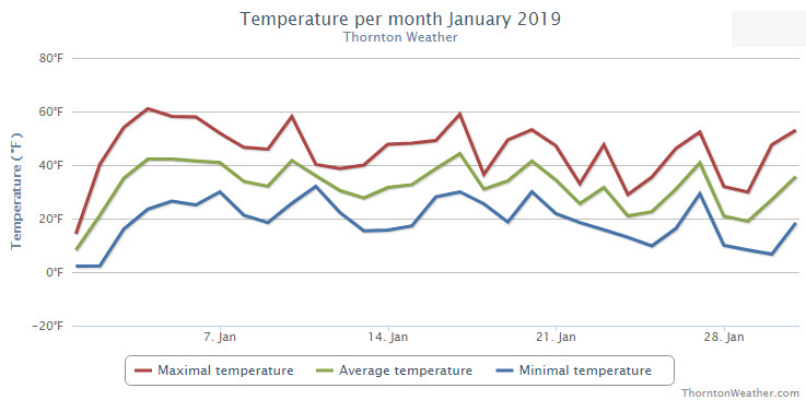
Finally! Our winter thus far had been quite dry so seeing some precipitation in January was a very welcome change. Temperatures were just a bit above normal.
Overall, the month was short on any sort of real weather drama with no major storms or particularly notable temperature extremes. However, a series of storm systems did give us a bit of a roller coaster of weather with five different snow events over the month.
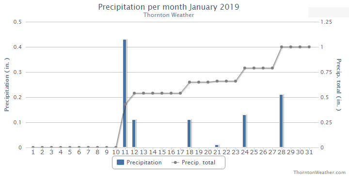
January started out with a very cold New Year’s Day but soon saw warmer temperatures arrive. Our first snow came on the 11th and 12th. This was followed by some smaller events and finally our biggest snowfall of the month on the 28th.
Thornton’s average temperature for the month came in at 31.3 degrees. This was a bit warmer than Denver’s long term overage for January of 30.7 degrees. Out at DIA where Denver’s official readings are taken, it was a bit warmer with an average of 32.0 degrees.
Our mercury readings ranged from a low of 2.2 degrees on the 1st and the 2nd to a high of 61.1 degrees a few days later on the 4th. Denver’s lowest reading was 5 degrees below zero on the first and its warmest of 62 degrees came on the 4th.
In terms of precipitation, Denver averages 0.41 inches of liquid precipitation during January. Thornton easily bested that with an even 1 inch in our bucket. Denver was above average as well with 0.75 inches.
Snowfall in Thornton saw above normal levels with a total for the month of 10.9 inches. Denver, as usual, lagged with 6.2 inches of the white stuff. The 30 year average for Denver for January is 7.0 inches.
Thornton, Colorado’s January 2019 temperature summary. (ThorntonWeather.com)Thornton, Colorado’s January 2019 precipitation summary. (ThorntonWeather.com)
CLIMATE REPORT
NATIONAL WEATHER SERVICE DENVER/BOULDER CO
1026 AM MST FRI FEB 1 2019

...................................

...THE DENVER CO CLIMATE SUMMARY FOR THE MONTH OF JANUARY 2019...

CLIMATE NORMAL PERIOD 1981 TO 2010
CLIMATE RECORD PERIOD 1872 TO 2019

WEATHER         OBSERVED          NORMAL  DEPART  LAST YEAR`S
                 VALUE   DATE(S)  VALUE   FROM    VALUE  DATE(S)
                                          NORMAL
................................................................
TEMPERATURE (F)
RECORD
 HIGH              76   01/27/1888
 LOW              -29   01/09/1875
HIGHEST            62   01/04        76     -14       68  01/09
LOWEST             -5   01/01       -29      24       -4  01/16
AVG. MAXIMUM     44.6              44.0     0.6     49.2
AVG. MINIMUM     19.5              17.4     2.1     20.1
MEAN             32.0              30.7     1.3     34.7
DAYS MAX >= 90      0               0.0     0.0        0
DAYS MAX <= 32      6               5.5     0.5        3
DAYS MIN <= 32     29              29.4    -0.4       28
DAYS MIN <= 0       1               1.7    -0.7        2

PRECIPITATION (INCHES)
RECORD
 MAXIMUM         2.35   1883
 MINIMUM         0.01   1933
                        1934
                        1952
TOTALS           0.75              0.41    0.34     0.54
DAILY AVG.       0.02              0.01    0.01     0.02
DAYS >= .01         6               4.1     1.9        5
DAYS >= .10         2               0.9     1.1        2
DAYS >= .50         0               0.0     0.0        0
DAYS >= 1.00        0               0.0     0.0        0
GREATEST
 24 HR. TOTAL    0.45   01/11 TO 01/11           01/21 TO 01/21

OBSERVED          NORMAL  DEPART  LAST YEAR`S

SNOWFALL (INCHES)
TOTALS            6.2               7.0
RECORD           24.3  1992

DEGREE_DAYS
HEATING TOTAL    1016              1063     -47      932
 SINCE 7/1       3388              3531    -143     3082
COOLING TOTAL       0                 0       0        0
 SINCE 1/1          0                 0       0        0

FREEZE DATES
RECORD
 EARLIEST     09/08/1962
 LATEST       06/08/2007
EARLIEST                        10/07
LATEST                          05/05
.................................................................

WIND (MPH)
AVERAGE WIND SPEED              9.9
RESULTANT WIND SPEED/DIRECTION   4/214
HIGHEST WIND SPEED/DIRECTION    40/290    DATE  01/07
HIGHEST GUST SPEED/DIRECTION    54/350    DATE  01/22

SKY COVER
POSSIBLE SUNSHINE (PERCENT)   MM
AVERAGE SKY COVER           0.50
NUMBER OF DAYS FAIR           10
NUMBER OF DAYS PC             17
NUMBER OF DAYS CLOUDY          4

AVERAGE RH (PERCENT)     58


-  INDICATES NEGATIVE NUMBERS.
R  INDICATES RECORD WAS SET OR TIED.
MM INDICATES DATA IS MISSING.
T  INDICATES TRACE AMOUNT.
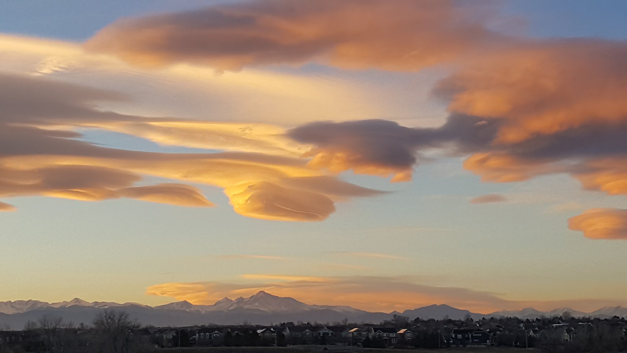
Stunning lenticular clouds at sunset over the Colorado Front Range. (David Canfield)
As one of our coldest months, January can be a good month to hibernate inside and avoid the outdoors. But, like any month in Colorado, photo opportunities abound as our monthly slideshow demonstrates.
Snow is not normally dominant in the month but when it does fall, it can create a beautiful blanket of white. Throw in the amazing sunrises and sunsets we receive in the middle of winter as well as wildlife and a host of other subjects and the imagery can be quite beautiful and stunning.
Slideshow updated January 29, 2019
To learn more about how to send your photo to us for inclusion in the slideshow, see below the slideshow.
Showcasing images captured by ThorntonWeather.com readers as well as some of our own, our monthly slideshow covers the entire gamut of weather-related imagery.
Sunsets, sunrises, wildlife and of course every type of weather condition are vividly depicted in images captured from yours and our cameras.
[flickr_set id=”72157677459558328″]
What is missing in the slideshow above? Your photo!
Our monthly photo slideshow is going to feature images that we have taken but more importantly images that you have captured. The photos can be of anything even remotely weather-related.
Landscapes, current conditions, wildlife, pets, kids. Whimsical, newsy, artsy. Taken at the zoo, some other area attraction, a local park, a national park or your backyard. You name it, we want to see and share it!
Images can be taken in Thornton, Denver or anywhere across the extraordinary Centennial State. We’ll even take some from out of state if we can tie it to Colorado somehow.
We’ll keep the criteria very open to interpretation with just about any image eligible to be shown in our slideshows.
What do you win for having your image in our slideshow? We are just a ‘mom and pop’ outfit and make no money from our site so we really don’t have the means to provide prizes. However you will have our undying gratitude and the satisfaction that your images are shared on the most popular website in Thornton.
To share you images with us and get them included in the slideshow just email them to us or share them with ThorntonWeather.com on any of the various social media outlets. Links are provided below.
Well, that was fun, eh? Well, probably not for those stuck in traffic when the snowstorm hit this morning.
The storm over-performed big time, far exceeding forecasts. Upslope flow pushed the system against the mountains and kept it in place over the Front Range.
Our east webcam captures it all in a time lapse.
Snow begins at about 3:00am and continued through much of the morning. By the end of the day though, blue skies returned and the snow was melting. We recorded 4.2 inches here but know many spots, particularly to the west, got more.
January 20 to January 26: This week in Denver weather history
Damaging wind events dominate our look back at this week in Denver weather history. Also making appearances are extreme cold and significant snowstorms.
14-21
In 1930…a protracted cold spell occurred when low temperatures plunged below zero on 8 consecutive days. The coldest low temperatures of 20 degrees below zero on the 17th and 19 degrees below zero on the 16th were record minimums for the dates. High temperatures during the period ranged from 18 on the 18th to zero on the 20th. Two degrees on the 15th was a record low maximum temperature for the date.
15-23
In 1962…a protracted cold spell kept metro Denver in the deep freeze for more than a week. From the 15th thru the 23rd…low temperatures were zero or below for 9 consecutive days…but a daily record low was set only on the 22nd when the temperature dipped to 14 degrees below zero. A record low maximum for the date was also set on the 22nd when the temperature climbed to only 11 degrees. The coldest high temperature was 3 degrees above zero on the 21st…which did not break the record. The protracted cold was broken for only a few hours on the afternoon of the 20th when Chinook winds warmed the temperature to a high of 38 degrees before another surge of cold arctic air plunged temperatures back into the deep freeze that evening. The severe cold caused much damage to water systems. A woman was frozen to death at Morrison. There were other deaths attributable to the weather…including traffic deaths and heart attacks from overexertion.
18-20
In 1958…snowfall totaled 6.9 inches at Stapleton Airport where east-northeast winds gusted to 26 mph on the 18th.
18-24
In 2005…a week of mid-winter unseasonably warm weather pushed high temperatures into the 60’s or more on all but one day. During the period…the highest temperature of 70 degrees on the 20th was a new record maximum for the date. Low temperatures remained above freezing on 4 of the days.
19-20
In 1935…snowfall of only 0.8 inch during the evening of the 19th was the only measurable snowfall of the month. The light snow developed behind an arctic cold front as temperatures plunged to a low of 13 degrees below zero on the 20th. High temperature of only 2 degrees on the 20th was a record low maximum for the date. Northeast winds were sustained to 16 mph on the 19th.
In 1986…Chinook winds gusting to 39 mph at Stapleton International Airport provided record breaking warmth. The warmest temperature of the month…68 degrees on the 19th…was also a record high for the date. The low temperature of 41 degrees on the 20th equaled the record high minimum for the date.
In 1991…a strong cold front moved south across metro Denver. Upslope conditions produced 3 to 6 inches of snow along the Front Range with 5 inches in Westminster and 4 inches in Thornton. Snowfall measured 4.9 inches at Stapleton International Airport where north winds gusted to 31 mph.
20
In 1894…northwest winds were sustained to 40 mph with gusts to 45 mph in the city.
In 1911…west Chinook winds sustained to 46 mph warmed the temperature to a high of 62 degrees.
In 1975…a warm Chinook wind produced a west wind gust to 53 mph at Stapleton International Airport. Winds were much stronger near the foothills…where 80 mph winds in Boulder caused damage to homes…buildings…power lines… And autos.
In 1986…high winds buffeted the foothills from Denver north. The strongest reported wind was 72 mph in Fort Collins. A wind gust to 39 mph was reported at Stapleton International Airport in Denver.
In 1996…high winds developed for a short time in the Front Range foothills in the wake of a weak upper level disturbance. Wondervu recorded a peak wind gust to 90 mph… While winds gusted to 84 mph atop squaw mountain near Idaho Springs. West winds gusted to only 29 mph at Denver International Airport.
In 2011…a snowboarder and his dog were killed when he triggered an avalanche in the backcountry northeast of Berthoud Pass.
20-21
In 1973…a major storm produced 7.5 inches of snowfall at Stapleton International Airport where north winds gusted to 32 mph causing some blowing snow.
In 2002…high winds developed over portions of the northern mountains and Front Range foothills. Several trees were blown down in Gilpin County along State Highways 119 and 46. Wind gust reports included: 90 mph 11 miles north of Central City…83 mph near Fritz Peak…76 mph at Aspen Springs…and 80 mph at Nederland. West winds gusted to only 39 mph at Denver International Airport on the 20th.
January 27 to February 2: This week in Denver weather history
High wind and heavy snow events dominate our look back at this week in Denver weather history. Most notable is a major snowstorm just last year that helped to provide at least some relief from tinder dry conditions. Hopefully we can see some of that this year!
From the National Weather Service:
25-27
In 1897…a cold spell resulted in three temperature records. Low temperature of 14 degrees below zero on the 27th was a record minimum for the date. High temperatures of only 3 degrees on the 25th and 2 degrees on the 26th were record low maximums for the dates. Very light snow or flurries fell on the 25th and 26th at times.
26-27
In 1944…heavy snowfall totaled 8.0 inches in downtown Denver. Most of the snow…7.0 inches…occurred on the 26th when northwest winds were sustained to 17 mph.
In 1973…at Stapleton International Airport…only 3.8 inches of snowfall were measured and north winds gusted to 40 mph causing some blowing snow…while over the Colorado eastern plains heavy snow accompanied by high winds created widespread blizzard conditions closing many highways.
In 1994…the combination of an upper level storm system and moist upslope winds brought heavy snow and cold temperatures to metro Denver and much of eastern Colorado. Snowfall across metro Denver averaged 5 to 7 inches. Snowfall totaled 3.8 inches at Stapleton International Airport where east winds gusted to 21 mph on the 26th.
In 2000…snow…heavy in the mountains…spread over the foothills and metro Denver. Eight inches of snow were measured at Bergen Park and near Evergreen. Snowfall totaled 3.8 inches at the site of the former Stapleton International Airport.
26-1
In 1888…a protracted warm spell lasted a week. Maximum temperatures ranged from 62 degrees on the 29th to an all-time record high for the month of 76 degrees on the 27th. Daily record high temperatures of 76…69…and 71 occurred on the 27th…28th…and 30th respectively. Record high minimum temperatures of 47 and 34 occurred on the 26th and 27th.
27
In 1888…the highest recorded temperature in January…76 degrees…occurred.
In 1967…strong winds caused a power outage in Boulder.
In 1984…this was the last day of 63 consecutive days with snow cover of one inch or more in Denver. This longest period of snow cover on record began with the Thanksgiving weekend blizzard on November 26-27…1983… When 21.5 inches of snow fell at Stapleton International Airport. Additional snowfall during December and January prolonged the event. Snow depth on the ground to the nearest inch was measured once daily at 5:00 am MST.
27-28
In 1899…snowfall totaled 6.2 inches in the city. Northeast winds were sustained to 36 mph with gusts to 40 mph on the 28th.
In 1965…high winds raked the Front Range foothills. West winds gusted to 89 mph on Table Mountain in Boulder…87 mph at Rocky Flats…and 54 mph at Stapleton International Airport. Damage and minor injuries occurred in Boulder and western metro Denver. Four men were injured by wind- caused accidents while working on construction…2 in Denver and 2 in Boulder. There was extensive damage to power lines… Buildings…signs…and trees. Some minor accidents were caused by blowing dust and debris. Blown dust accumulated 2 to 3 feet deep on some lawns in northern metro Denver suburbs. Dust blew into buildings and homes.
In 1989…the heaviest snowstorm of the winter dumped 9 to 15 inches of snow across metro Denver. Snowfall totaled 8.8 inches at Stapleton International Airport with most of the snow…8.6 inches…falling on the 28th. Strong north winds gusting to 46 mph whipped the snow into 2-foot drifts and reduced visibility in blowing snow. The foothills received up to 18 inches of snow. The snow fell on a weekend…so closures and other disruptions were minimal. The public reported thunder in Arvada…Wheat Ridge…and Boulder on the evening of the 27th. A thunderstorm produced snow pellets at Stapleton International Airport during the early morning hours of the 28th. This was the first thunderstorm in the city during January since 1932.
In 1996…winds to hurricane force were reported across the Front Range foothills in the wake of a pacific storm system. Recorded wind speeds included: 86 mph at the National Center for Atmospheric Research southwest of Boulder…86 mph atop Squaw Mountain west of Denver…and 75 mph at Jefferson County Airport in Broomfield. West-northwest winds gusted to 48 mph at Denver International Airport on the 28th.
In 2009…high winds buffeted the foothills of Boulder and Jefferson counties. Peak wind gusts included: 101 mph at Eldora Ski Resort…100 mph…6 miles northwest of Boulder; 84 mph at NCAR Mesa Lab…79 mph…5 miles northwest of Boulder; and 75 mph at the national wind technology center. In Nederland…a wind turbine recently installed was damaged by the high winds. A peak wind gust of 38 mph occurred at Denver International Airport on the 28th.
27-31
In 1951…a major storm dumped 10.1 inches of snowfall at Stapleton Airport. Most of the snow…8.3 inches…fell on the 29th. Cold arctic air accompanied the snow. Several temperature records were set…including record low maximum temperatures of 4 on the 28th and 4 below zero on the 29th and record low temperatures of 12 below zero on the 29th and 24 below zero on the 31st. Temperatures were below zero for 45 consecutive hours.
28
In 1872…the low temperature dipped to 22 degrees below zero… A record minimum for the date.
In 1909…gale force north winds were sustained to 45 mph behind an apparent cold front…which also produced a trace of snow.
In 1986…a wind gust to 67 mph was recorded in Boulder. West winds gusted to 41 mph at Stapleton International Airport.
28-29
In 1956…snowfall totaled 5.5 inches at Stapleton Airport where east winds gusted to 32 mph on the 28th.
In 1972…cold west winds buffeted Boulder. A wind gust to 92 mph was recorded at the National Bureau of Standards…while a gust to 76 mph was measured in downtown Boulder. Two mobile homes were overturned in Boulder. Other damage was minor. Northwest winds gusted to 40 mph at Stapleton International Airport on the 28th.
In 1987…strong winds buffeted the Front Range foothills and spread east over the plains. The highest wind recorded was 99 mph on the 29th at both the National Center for Atmospheric Research in Boulder and the Rocky Flats plant south of Boulder. Wind gusts in excess of 80 mph were common. A northwest wind gust to 54 mph was recorded at Stapleton International Airport on the 28th with a gust to 41 mph on the 29th. Planes were damaged at both the Boulder and Jefferson County Airports. Hangars were also damaged at Jefferson County Airport. Many windows were broken…signs toppled…and trees downed. A brick wall was blown onto parked cars in Lakewood. A couple of houses in Lakewood were unroofed…while falling trees damaged others. Two people were injured by flying debris in Lakewood and Golden. Total insured damage along the Front Range was 10 million dollars making the wind storm the second most costly on record in Colorado at the time.
In 1995…deepening upslope winds along the eastern foothills on the 28th gave way to periods of heavy snow during the night and early morning hours of the 29th. Snow fell to a depth of 8 inches in both Golden and Boulder with up to a foot in the foothills. Only 1.9 inches of snow fell at Stapleton International Airport…where east winds gusted to 22 mph on the 28th.
In 2001…heavy snow fell across metro Denver. The heaviest snowfall occurred from just south of Denver to around Castle Rock. Snow amounts included: 12 inches east of Parker…9 inches near Elizabeth and in Littleton…8 inches near Castle Rock and in Parker…and 7 inches in Aurora. Snowfall totaled 6.0 inches at the site of the former Stapleton International Airport.
28-30
In 1887…winds were strong and gusty for three days in the city. West and northwest winds were sustained to 56 mph on both the 28th and 29th and to 44 mph on the 30th. Temperatures warmed to a high of 57 degrees on the 29th.
29
In 1900…northwest winds were sustained to 45 mph with an extreme velocity of 46 mph.
In 1914…this was the last day of 60 consecutive days with snow cover of one inch or more in Denver. This third longest period of snow cover on record began with the record breaking snow and blizzard on December 1-5… 1913 when a total of 45.7 inches of snow fell in downtown Denver. Additional snowfall during December and January prolonged the event. Snow depth on the ground to the nearest tenth of an inch was measured once daily at 6:00 pm MST.
In 1927…west winds were sustained at 40 mph with gusts to 42 mph.
In 1942…heavy snowfall totaled 6.2 inches in downtown Denver. North winds were sustained to 17 mph.
In 1965…strong winds occurred in Boulder for the third consecutive day. Only limited minor damage was reported. Northwest winds gusted to 40 mph at Stapleton International Airport.
In 1984…highs winds in and near the foothills produced wind gusts as high as 71 mph in Boulder. A plane was flipped over at Jefferson County Airport and damaged beyond repair. In Lakewood…two construction trailers were damaged by the gusts. North winds gusted to only 38 mph at Stapleton International Airport.
In 1990…gale to hurricane force winds gusts raked the foothills. Wind gusts of 50 to 90 mph were common in Boulder County. A peak wind of 94 mph was clocked at Table Mesa in southwest Boulder. Scattered power outages and minor property damage were reported. West winds gusted to 46 mph at Stapleton International Airport.
January 13 to January 19: This week in Denver weather history
Cold, snow and wind are expected this time of year in northeastern Colorado as we have seen many notable events with those conditions in our past. Notably in our look back at this week in Denver weather history we see that extreme versions of these can lead to injury and even death.
From the National Weather Service:
10-13
In 1963…an arctic cold wave plunged temperatures well below zero across metro Denver. Temperatures were below zero for a total of 64 consecutive hours. Low temperatures reached 25 degrees below zero on both the 11th and 12th. The high temperature of 9 degrees below zero on the 11th was the coldest ever recorded at Stapleton Airport and equaled the record low maximum for the month first set on January 19…1883…in downtown Denver. The high temperature on the 12th reached only 1 degree below zero. On the 12th…an 18-year-old youth died of exposure from the extreme cold in Denver. There were many losses and damage to property from frozen water systems…stalled cars…and over-burdened heating systems. Light snow accompanied the arctic blast. At Stapleton Airport…2.3 inches of snow fell on the 10th and 11th.
11-14
In 1997…cold arctic air plunged temperatures below zero across metro Denver. The temperature was below zero for 60 consecutive hours from the afternoon on the 11th to around daybreak on the 14th. The high temperature of only 1 degree below zero on the 12th equaled the record low maximum for the date last set in 1963. The low temperature dipped to 14 degrees below zero on the 12th.
12-13
In 1936…strong winds in Boulder blew roofs off homes. Wind gusts over 60 mph were recorded at the University of Colorado and a gust to 55 mph measured at Valmont.
In 2002…high winds developed in the foothills on the 12th and spread over the plains on the 13th. Winds gusted to 76 mph at the National Center for Atmospheric Research on the mesa in Boulder on the 12th. Northwest winds gusted to 49 mph…the highest wind of the month…at Denver International Airport on the 13th. The strongest winds were north and northeast of metro Denver.
13
In 1875…the low temperature dipped to 20 degrees below zero… A record low for the date and climbed to a high of only 2 degrees below zero…a record low maximum for the date.
In 1880…the worst wind storm ever experienced in Boulder caused some damage and personal injuries.
In 1893…northwest winds were sustained to 42 mph in the city.
In 1904…northwest winds were sustained to 40 mph with gusts as high as 50 mph. The Chinook winds warmed the temperature to a high of 63 degrees. The low temperature remained above freezing…dipping to only 34 degrees.
In 1919…snowfall was 1.8 inches in downtown Denver. Melted snow resulted in only 0.12 inch of precipitation. This was the only snowfall and precipitation for the month.
In 1932…snowfall totaled 3.4 inches in downtown Denver. North winds gusted to 22 mph.
In 1967…high winds in Boulder gusted to 70 mph downtown. Some damage occurred. Northwest winds gusting to 38 mph at Stapleton International Airport produced some blowing dust.
In 1988…high winds occurred in Boulder with a wind gust to 70 mph at Table Mesa. In the foothills a wind gust to 82 mph was measured at Rollinsville. West winds gusted to 33 mph at Stapleton International Airport.
13-14
In 1960…snowfall totaled only 4.4 inches and northeast winds gusted to 28 mph at Stapleton Airport…while over southeast Colorado a near blizzard closed roads with drifts 3 to 6 feet deep.
13-16
In 1888…a cold air mass settled over the city and caused temperatures to plunge well below zero on four consecutive days…but only one temperature record was set. Minimum temperatures dipped to 4 degrees below zero on the 13th… 19 degrees below zero on the 14th…20 degrees below zero on the 15th…and 11 degrees below zero on the 16th. The maximum temperature of only 4 degrees below zero on the 14th was a record low maximum for the date. North winds were sustained to 30 mph on the 13th.
14
In 1873…winds were brisk all day. After sunset…northeast sustained winds produced a perfect gale…behind an apparent cold front.
In 1875…the temperature remained below zero all day with a general northeast wind. At 9:00 pm the temperature was 1 degree above zero which was the official high for the day. The wind suddenly veered to the southwest and the temperature climbed 19 degrees in 15 minutes…7 more degrees in the next 5 minutes…and by 9:30 pm had risen to 36 degrees. By 9:35 pm the temperature had reached 40 degrees…a rise of 48 degrees in one hour and 39 degrees in half an hour. The sudden rise in temperature could be attributed to a receding arctic air mass and downsloping surface winds.
In 1906…the temperature climbed to a high of 56 degrees before an apparent cold front produced northeast winds sustained to 40 mph and a trace of snow in the afternoon.
In 1921…west winds were sustained to 44 mph with gusts to 46 mph. The downslope winds warmed the temperature to a high of 49 degrees.
In 1967…3.7 inches of snow fell at Stapleton International Airport with 7.7 inches measured in Boulder.
In 1982…strong Chinook winds buffeted Boulder…tearing the roof off a small apartment building. A gust to 88 mph was measured in Lakewood. Wind gusts of 60 to 80 mph were common along the foothills from Denver north to Fort Collins. Four people sustained minor injuries…mostly from flying glass. At least one person was knocked down by the winds. Several tractor trailer rigs were blown off I-70 near Golden…and numerous camper shells were blown off pick-up trucks.
14-15
In 1908…heavy post-frontal snowfall totaled 6.5 inches overnight. North winds were sustained to 32 mph. The temperature dropped 41 degrees in 24 hours from a reading of 48 degrees at 8:00 pm on the 14th to only 7 degrees at 8:00 pm on the 15th.
In 1950…strong winds occurred in Boulder and Louisville. Winds in excess of 60 mph were recorded at Valmont. Minor damage was reported. Southwest winds gusted to 50 mph at Stapleton Airport.
In 1959…a total of 5.5 inches of snow fell at Stapleton Airport.
In 1992…snow spread from the mountains across metro Denver. The heaviest snow was across the northern portion of the area where 7 inches fell at Thornton. At Stapleton International Airport…only 3.4 inches of snowfall were recorded and northeast winds gusting to 37 mph caused some blowing snow on the 14th.
In 1999…high winds howled across metro Denver. In Commerce City…strong winds toppled 3 utility poles resulting in a power outage to 600 homes. High wind reports included: 108 mph at Wondervu…80 mph at the Hiwan Golf Course in Evergreen…76 mph at Aspen Springs…75 mph at the Jefferson County Airport near Broomfield…74 mph in Boulder…and 70 mph at Georgetown. West to northwest winds gusted to 48 mph…the highest wind gust of the month…and warmed the temperature to a high of 60 degrees at Denver International Airport on the 15th.
14-21
In 1930…a protracted cold spell occurred when low temperatures plunged below zero on 8 consecutive days. The coldest low temperatures of 20 degrees below zero on the 17th and 19 degrees below zero on the 16th were record minimums for the dates. High temperatures during the period ranged from 18 on the 18th to zero on the 20th. Two degrees on the 15th was a record low maximum temperature for the date.
January 6 to January 12: This week in Denver weather history
Extreme cold would be the first thing to come to your mind when you think of January. While there have been many such notable events of that nature, our look back at this week in Denver weather history actually is more remarkable for the damaging wind that has raked the area in the past.
From the National Weather Service:
31-6
In 1973…the 31st marked the start of a protracted cold spell that extended into January of 1974 when temperatures dipped below zero on 7 consecutive days. Record daily minimum readings occurred on the 3rd and 5th when the temperature plunged to 17 degrees below zero on both days. A record low daily maximum temperature of only 4 degrees occurred on the 5th.
31-7
In 1941…a protracted cold spell through January 7…1942… Produced below zero low temperatures on 7 of the 8 days. A low temperature of 2 degrees on the 3rd prevented a string of 8 days below zero. The coldest days during the period were the 1st with a high of 2 degrees and a low of 9 degrees below zero…the 4th with a high of 2 degrees and a low of 11 degrees below zero…and the 5th with a high of 26 degrees and a low of 12 degrees below zero.
5-6
In 1940…snowfall totaled 5.9 inches in downtown Denver.
In 1975…high winds gusting to over 75 mph caused considerable damage in the Boulder area and minor damage in Jefferson County.
In Boulder…one home was unroofed… Several power lines were blown down…and a number of homes and commercial buildings were damaged. Northwest winds gusted to 36 mph on the 5th and 38 mph on the 6th at Stapleton International Airport.
In 1980…high winds in and near the foothills shattered windows…tore roofs from buildings…and caused many power outages. Much of the damage was in Boulder…where winds gusted to at least 82 mph. Wind gusts of 80 to 100 mph were common in the foothills. West winds gusted to only 37 mph at Stapleton International Airport on the 6th.
In 1982…2 to 6 inches of snow fell across metro Denver. Only 1.1 inches of snow were measured at Stapleton International Airport.
In 1983…high winds buffeted the foothills with gusts of 60 to 75 mph recorded in the Boulder area. West winds gusted to only 38 mph at Stapleton International Airport on the 6th.
In 1998…heavy snow blanketed the Front Range foothills. Snowfall totals included: 15 inches 8 miles north of Blackhawk; 13 inches at Evergreen and 5 miles east of Nederland; 12 inches in Coal Creek Canyon; 11 inches 8 miles west of Conifer; 10 inches in sunshine canyon northwest of Boulder; 10 inches 11 miles southwest of Morrison; 9 inches in south turkey canyon; and 8 inches at Eldora Ski Area. Snowfall totaled only 1.8 inches at the site of the former Stapleton International Airport.
6
In 1903…northwest winds were sustained to 45 mph with an extreme velocity of 48 mph. The Chinook winds warmed the temperature to a high of 66 degrees…which was a record maximum for the date. The low temperature dipped to only 35 degrees.
In 1962…strong winds caused nearly 14 hundred dollars in damage 2 miles north of Boulder. West-northwest Chinook winds gusted to 33 mph at Stapleton Airport in advance of a cold front that produced northeast wind gusts to 43 mph along with some blowing dust and 0.1 inch of snow.
In 1972…a wind gust to 69 mph was recorded at the National Bureau of Standards in Boulder. Only minor damage occurred. Northwest winds gusted to 33 mph at Stapleton International Airport.
In 2007…a large avalanche swept two vehicles off U.S. Highway 40…near Berthoud Pass…and partially buried them. The slide covered all three lanes of the highway. Eight people were in the vehicles…but only one person was seriously injured. He suffered several broken ribs. The slide was approximately 200 feet wide and 15 feet deep.
6-7
In 1908…furious high winds were noted in Boulder but caused only minor damage and injury.
In 1913…a very cold arctic air mass caused temperatures to plunge to record levels. The low temperature fell to 21 degrees below zero on the 6th and to 18 degrees below zero on the 7th…both records. The high temperature of only 8 degrees below zero on the 6th was a record low maximum for the date.
In 1920…post-frontal heavy snowfall totaled 7.0 inches in downtown Denver. North winds were sustained at 24 mph with gusts to 30 mph on the 6th.
In 1923…warm Chinook winds resulted in two temperature records. Low temperatures of 37 degrees on the 6th and 42 degrees on the 7th equaled the record high minimums for the dates. West winds were sustained to 30 mph with gusts to 33 mph on the 6th. Southwest winds were sustained to 47 mph with gusts to 52 mph on the 7th. High temperatures were 53 degrees on the 6th and 56 degrees on the 7th.
In 1986…2 to 4 inches of snow fell over metro Denver… With 5 to 8 inches in the foothills west of the city. The 2.4 inches of snowfall recorded at Stapleton International Airport was the only snowfall of the month. Northwest winds gusted to 24 mph at the airport.
In 2006…a brief warm spell resulted in two temperature records. High temperatures of 66 degrees on the 6th and 69 degrees on the 7th equaled the record daily maximum temperatures for each of those days. Low temperatures remained above freezing and were within 1 or 2 degrees of the record daily high minimums.
7
In 1911…west Chinook winds were sustained to 51 mph and warmed the temperature to a high of 56 degrees.
In 1994…occasional high winds buffeted the eastern foothills. Wind gusts to 99 mph were recorded at Rollinsville…southwest of Boulder. West winds gusted to 40 mph at Stapleton International Airport.
In 1995…a brief blast of high winds hit the eastern foothills and adjacent Front Range communities. A wind gust to 112 mph was recorded atop Squaw Mountain…west of Denver. In Boulder…winds gusted to 81 mph. West winds gusted to 31 mph at Stapleton International Airport.
In 2009…damaging downslope winds were responsible for triggering two wildfires that threatened the city of Boulder. Peak wind gusts ranged from 75 to 107 mph in and near the foothills of Boulder…Jefferson and Park counties. Although the fires never merged…they were close enough for firefighters to build a perimeter around both of them. The fires quickly torched 3000 acres and forced the evacuation of up to 1400 families. One home was destroyed along with several barns and outbuildings. Three firemen suffered minor injuries. In Bailey…power lines were downed by falling trees. A tin roof on an auto repair shop in town was almost completely blown off. Peak wind gusts included: 107 mph…3 miles south of Mt. Audobon…92 mph…3 miles south of Evergreen; 87 mph…6 miles northwest of Boulder; 81 mph…2 miles east-northeast of Bergen Park and at the National Wind Technology Center; 79 mph…4 miles northeast of Nederland; 77 mph…3 miles west of Sheridan; 75 mph at Genesee. A peak wind gust of 39 mph was measured at Denver international Airport from the west.
7-8
In 1911…gale force winds occurred in Boulder causing minor injuries.
In 1937…cold arctic air plunged temperatures below zero for an estimated 56 consecutuve hours. Two temperature records were set. High temperatures of 8 degrees below zero on the 7th and 3 degrees on the 8th were record low maximum readings for those dates. Low temperatures plunged to 12 degrees below zero on the 7th and 11 degrees below zero on the 8th. Snowfall was 1.4 inches in downtown Denver.
In 1969…a violent evening windstorm struck Boulder and the adjacent foothills. A wind gust to 130 mph was recorded at the National Center for Atmospheric Research. Winds reached 96 mph in downtown Boulder. The Boulder airport wind recorder was blown away after measuring a wind gust to 80 mph. The windstorm caused over one million dollars in damage and one fatality in Boulder. About 25 homes in south Boulder had roofs blown off or were severely damaged. Roofs were blown off buildings housing scientific laboratories and offices of the Environmental Science Services Administration…now NOAA…in Boulder…and installations of several scientific measuring sites near Boulder received heavy damage. Grass fires driven by the high winds endangered many areas…but were controlled by volunteer firemen. One man died from injuries received when he was blown from a fire truck. One man was killed and another injured when the truck camper in which they were riding was blown off I-25 about 10 miles north of Denver. In the same area a mobile home and a truck trailer were blown off the highway and demolished. At least 20 people in the Boulder area received light to serious injuries from flying debris or from being blown into obstructions. Power lines and trees were downed over a wide area. Damage was relatively light in the city of Denver…where northwest winds gusted to 62 mph at Stapleton International Airport on the 8th. Many windows were broken in Arvada…Englewood…and Littleton. A 27-year-old fire lookout tower on Squaw Mountain…west of Denver…was blown away…and several radio relay towers at that location were toppled. Trucks were overturned near Georgetown. Mobile homes were overturned in several areas with occupants receiving injuries in some cases. The strong Chinook winds also brought warm weather. The maximum temperature of 69 degrees on the 7th broke the old record of 65 degrees set in 1948. The temperature also reached 65 degrees on the 8th…but was not a record.
In 1992…an intense blizzard buried eastern parts of metro Denver. At times snow fell at rates of 2 to 3 inches an hour. Winds increased from the north at speeds of 25 to 45 mph. Drifts of 4 to 8 feet were common. I-70 was closed east of Denver…and I-25 was closed from Denver south. Snowfall totals ranged from a couple of inches in the foothills west of Denver to as much as 2 feet on the east side of metro Denver. The heaviest snow fell on the 7th in a band from the northern suburbs of Westminster and Thornton through Aurora and east Denver to southeast of Parker. Snowfall totals included: 22 inches in southeast Aurora…14.8 inches at Stapleton International Airport…13 inches in Northglenn…10 inches in Parker…and 9 inches in Westminster. The 14.5 inches of snowfall measured on the 7th into the 8th is the greatest 24 hour snowfall ever recorded in the city during the month of January. North winds gusting to 46 mph caused much blowing snow at Stapleton International Airport.
In 2000…high winds developed in and near the Front Range foothills. The strongest winds were generally confined to foothills areas north of I-70. A wind gust to 76 mph was reported in Golden Gate Canyon. West winds gusted to 37 mph at Denver International Airport on the 8th.
7-10
In 1962…a major winter storm dumped 13.5 inches of snow on metro Denver. A foot of the snow fell on the 8th when northeast winds gusted to 30 mph. The storm was followed by an intense blast of very cold arctic air. Minimum temperature readings of 24 degrees below zero occurred on both the 9th and 10th. The temperature never reached above zero on the 9th when a maximum reading of 1 degree below zero was recorded. Temperatures were below zero for 37 consecutive hours.
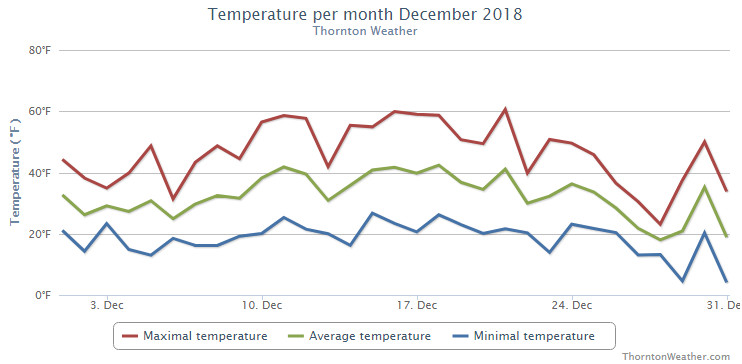
Thornton’s December was lacking in terms of any sort of real weather drama. Temperatures were relatively mild for much of the month and precipitation was fleeting.
Above normal temperatures were the general rule for the first part of the month. It was only the last week of the month when Arctic air arrived and we saw temperatures drop considerably. We saw only two measurable snow events, neither of which amounted to much.
Overall, Thornton’s average temperature for the month was 30.8 degrees. This was nearly a full degree above Denver’s long term December average of 30.0 degrees. Out at DIA where the Mile High City’s official measurements are taken, it was a good bit warmer with an average of 32.5 degrees.
Temperatures in Thornton ranged from a high of 60.6 degrees on the 21st down to a low of 4.5 degrees on the morning of the 29th. Denver’s warmest reading of 63 degrees also came on the 21st and its coldest, 0 degrees, on the 31st.
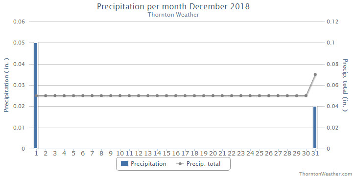
Denver averages 0.35 inches of precipitation during December. Thornton fell well short with a mere 0.07 inches. Out at the airport, even less was realized with 0.03 being recorded. This puts December 2018 into the books as one of the driest Decembers ever recorded.
Thornton recorded a mere 0.9 inches of snow during the month, the majority of which fell on the last day of the month. Denver saw 0.5 inches, all on the 31st. Both fall well short of the long term Denver average for December snowfall of 8.5 inches and put December 2018 on the list of the ten least snowy Decembers recorded.
Ten least snowy December’s in Denver weather history:
TRACE – 1905, 1906, 2002
0.1 – 1928
0.4 – 1890
0.5 – 1935, 2018
0.6 – 1995
0.7 – 1977, 1895
Thornton, Colorado’s December 2018 Temperature Summary. (ThorntonWeather.com)Thornton, Colorado’s December 2018 Precipitation Summary. (ThorntonWeather.com)
CLIMATE REPORT
NATIONAL WEATHER SERVICE DENVER/BOULDER CO
936 AM MST TUE JAN 1 2019

...................................

...THE DENVER CO CLIMATE SUMMARY FOR THE MONTH OF DECEMBER 2018...

CLIMATE NORMAL PERIOD 1981 TO 2010
CLIMATE RECORD PERIOD 1872 TO 2018

WEATHER         OBSERVED          NORMAL  DEPART  LAST YEAR`S
                 VALUE   DATE(S)  VALUE   FROM    VALUE  DATE(S)
                                          NORMAL
................................................................
TEMPERATURE (F)
RECORD
 HIGH              79   12/05/1939
 LOW              -25   12/22/1990
                        12/24/1876
HIGHEST            63   12/21        62       1       69  12/12
LOWEST              0   12/31        -4       4       -4  12/24
AVG. MAXIMUM     46.1              42.8     3.3     48.3
AVG. MINIMUM     18.8              17.1     1.7     18.0
MEAN             32.5              30.0     2.5     33.2
DAYS MAX >= 90      0               0.0     0.0        0
DAYS MAX <= 32      4               5.8    -1.8        4
DAYS MIN <= 32     31              29.4     1.6       28
DAYS MIN <= 0       1               2.0    -1.0        1

PRECIPITATION (INCHES)
RECORD
 MAXIMUM         5.21   1913
 MINIMUM         0.00   1881
TOTALS           0.03              0.35   -0.32     0.21
DAILY AVG.       0.00              0.01   -0.01     0.01
DAYS >= .01         1               4.1    -3.1        4
DAYS >= .10         0               1.1    -1.1        1
DAYS >= .50         0               0.1    -0.1        0
DAYS >= 1.00        0               0.0     0.0        0
GREATEST
 24 HR. TOTAL    0.03   12/31 TO 12/31

SNOWFALL (INCHES)
TOTALS            0.5               8.5

DEGREE_DAYS
HEATING TOTAL     999              1086     -87      979
 SINCE 7/1       2372              2468     -96     2150
COOLING TOTAL       0                 0       0        0
 SINCE 1/1       1026               769     257      881

FREEZE DATES
RECORD
 EARLIEST     09/08/1962
 LATEST       06/08/2007
EARLIEST                        10/07
LATEST                          05/05
.................................................................

WIND (MPH)
AVERAGE WIND SPEED              9.6
RESULTANT WIND SPEED/DIRECTION   2/222
HIGHEST WIND SPEED/DIRECTION    39/010    DATE  12/12
HIGHEST GUST SPEED/DIRECTION    53/010    DATE  12/12

SKY COVER
POSSIBLE SUNSHINE (PERCENT)   MM
AVERAGE SKY COVER           0.50
NUMBER OF DAYS FAIR            6
NUMBER OF DAYS PC             22
NUMBER OF DAYS CLOUDY          3

AVERAGE RH (PERCENT)     51

-  INDICATES NEGATIVE NUMBERS.
R  INDICATES RECORD WAS SET OR TIED.
MM INDICATES DATA IS MISSING.
T  INDICATES TRACE AMOUNT.
Weather, natural disasters & climate news and information.
 February in Colorado typically brings to an end an extended period when average temperatures are at their lowest. Winter begins to loosen its grip and temperatures get warmer but precipitation is not a particularly common event during the month.