The storm might be over but its effects continue to be felt in the form of very cold temperatures. This morning Denver recorded its coldest temperature ever for October 31.
In the pre-dawn hours the temperature at Denver International Airport dropped to 7 degrees. This handily bested the record low temperature for the date of 10 degrees set in 1991.
Here in Thornton we were just a bit colder with a low of 5 degrees.
The Mount Lindo cross glows over the city of Denver at twilight. (Bill Hutchinson)
October in Thornton can bring a wide variety of weather conditions, perfect for the photographer in all of us.
The month brings the changing of the colors at Colorado’s lower elevations and it is also is typically when we see our first freeze and first snow.
Couple those facts with our usual widely varying landscapes and wildlife and we have a month that is sure to bring in plenty of photo opportunities.
Slideshow updated October 31, 2019
To learn more about how to send your photo to us for inclusion in the slideshow, see below the slideshow.
Showcasing images captured by ThorntonWeather.com readers as well as some of our own, our monthly slideshow covers the entire gamut of weather-related imagery.
Sunsets, sunrises, wildlife and of course every type of weather condition are vividly depicted in images captured from yours and our cameras.
[flickr_set id=”72157711281326282″]
What is missing in the slideshow above? Your photo!
Our monthly photo slideshow is going to feature images that we have taken but more importantly images that you have captured. The photos can be of anything even remotely weather-related.
Landscapes, current conditions, wildlife, pets, kids. Whimsical, newsy, artsy. Taken at the zoo, some other area attraction, a local park, a national park or your backyard. You name it, we want to see and share it!
Images can be taken in Thornton, Denver or anywhere across the extraordinary Centennial State. We’ll even take some from out of state if we can tie it to Colorado somehow.
We’ll keep the criteria very open to interpretation with just about any image eligible to be shown in our slideshows.
What do you win for having your image in our slideshow? We are just a ‘mom and pop’ outfit and make no money from our site so we really don’t have the means to provide prizes. However you will have our undying gratitude and the satisfaction that your images are shared on the most popular website in Thornton.
To share you images with us and get them included in the slideshow just email them to us or share them with ThorntonWeather.com on any of the various social media outlets. Links are provided below.
The United States returns to Standard Time at 2:00am Sunday as Daylight Saving Time comes to an end.
The biannual ritual of changing our clocks to adjust for Daylight Saving Time occurs this weekend, providing yet another signal of the changing of seasons. The United States will ‘fall back’ one hour at 2:00am Sunday morning as we return to Standard Time.
The ritual of changing our clocks twice a year can be met with some resistance as some people struggle to adjust their body’s internal clock. Others actually like the return to standard time as they get to enjoy an extra hour of sleep.
The time change definitely has big effects on the dawning of daylight and how early it gets dark in the evening.
Sunrise on Saturday occurs at 7:29am but on Sunday it will be at 6:30am. Similarly, sunset will occur at 5:56pm on Saturday but on Sunday the sun will disappear over the horizon at 4:55pm.
For many this means that when they get home from work it will now be dark and outdoor activities will be significantly curtailed as a result.
Arizona and Hawaii are the only states that do not observe Daylight Saving Time and remain on Standard Time year round. The U.S. territories of Puerto Rico, American Samoa, Guam, Northern Mariana Islands, and the United States Virgin Islands also do not observe the event.
It won’t be all that long though before Daylight Saving Time returns. On March 8, 2020 we will ‘spring forward.’
Daylight Saving Time Schedule
The mandated beginning and end of Daylight Saving Time has changed in the United States over the years.
The most recent schedule was set by the Energy Policy Act of 2005 and took effect in 2007. We now ‘spring forward’ to begin Daylight Saving Time on the second Sunday in March and ‘fall back’ with the return to Standard Time on the first Sunday in November.
Denver’s official temperature this morning dropped to 3 degrees as measured at Denver International Airport. That broke the record low temperature for October 30 of 7 degrees set in 1991.
Thornton saw similarly bone-chilling cold with a low of 4 degrees this morning.
Today, temperatures are going to run about 40 degrees below normal. Further, there is a good chance we set another record low temperature tomorrow morning. The record low for October 31 is 10 degrees and current indications are we could dip to near 0 degrees.
Not only did we receive a healthy shot of snow with this latest storm, we also saw some very cold temperatures. In fact, the first of what could be a few cold temperature records has been set.
As measured at Denver International Airport, the Mile High City’s official high temperature today was only 18 degrees. Not only was that more than 40 degrees below average, it also sets a record for the coldest high temperature for October 29. The old record was 25 degrees set in 1993.
Here in Thornton, we were just a bit “warmer” with a high of 20 degrees.
The record-breaking cold is not done either. There is a good chance Denver sets a record low tomorrow morning and on Thursday morning.
As measured at Denver International Airport, the Mile High City’s official low temperature this morning was 9 degrees. That absolutely shattered the previous record low temperature for the date of 22 degrees set in 1946.
Thornton saw extremely cold temperatures as well, although not quite as cold as DIA. Our low came in at 15 degrees.
On a related note, yesterday’s snowfall was the first of the season and brought Thornton 3.3 inches of the white stuff. Officially, as measured at DIA, Denver recorded 1.0 inches.
Friday and the weekend will see us break out of the cold with a warming trend that will see mercury levels back near normal on Sunday. Get the forecast here.
While our first snowfall of the season had ended, the cold was just beginning.
Just before midnight on Thursday, the temperature at Denver International Airport fell to 13 degrees.
This easily beat the record low temperature for October 10 of 17 degrees set in 2009.
Thornton managed to stay warmer with our low of 20 degrees coming in the morning.
The temperature will continue to drop tonight and into early Friday morning. It starts with record setting cold and now we will wait and see just how cold it gets.
Looking ahead, the weekend will offer up gradually warming temperatures with Sunday returning us to near normal readings.
For the second month in a row, Thornton saw temperatures well above normal and precipitation well below average. While the first half of 2019 started out cool and wet, the second appears to be headed the opposite direction.
High pressure was the dominating feature for the month. This served to keep precipitation away and colder air to our north.
The result was clear and served to make September 2019 one of the warmest Septembers on record. In fact, it was Denver’s second warmest September on record. Thornton wasn’t as warm but here too, it was our second warmest September since Thornton Weather launched 13 years ago.
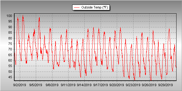
Overall, Thornton saw an average temperature for the month of 67.0 degrees. This was well above Denver’s long term average temperature for September of 63.4 degrees. Out at DIA where the Mile High City’s official measurements are taken, it was even warmer with an average of 69.3 degrees for the month.
Temperatures in Thornton ranged from a high of 101 degrees on the 1st and 2nd down to a low of 41.7 degrees on the morning of the 26th. Denver’s maximum temperature for the month of 100 degrees came on the 2nd and its coldest of 40 degrees on the 22nd.
Denver’s 100 degree reading on the 2nd was not only a record high for the date, but it also was the latest in the year a 100 degree reading has ever been recorded. The old record was August 16th in 2002. Record high temperatures of 98 degrees were also recorded on the 1st and 5th.
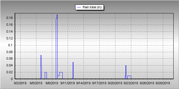
In terms of precipitation, Denver averages 0.96 inches during September. Thornton and Denver recorded identical totals in September 2019 of 0.41 inches, less than half of the average.
Thornton, Colorado’s September 2019 temperature summary. (ThorntonWeather.com)Thornton, Colorado’s September 2019 precipitation summary. (ThorntonWeather.com)
CLIMATE REPORT
NATIONAL WEATHER SERVICE DENVER/BOULDER CO
826 AM MDT TUE OCT 1 2019

...................................

...THE DENVER CO CLIMATE SUMMARY FOR THE MONTH OF SEPTEMBER 2019...

CLIMATE NORMAL PERIOD 1981 TO 2010
CLIMATE RECORD PERIOD 1872 TO 2019

WEATHER         OBSERVED          NORMAL  DEPART  LAST YEAR`S
                 VALUE   DATE(S)  VALUE   FROM    VALUE  DATE(S)
                                          NORMAL
................................................................
TEMPERATURE (F)
RECORD
 HIGH             100   09/02/2019
 LOW               17   09/29/1985

HIGHEST           100R  09/02        91       9       96  09/13
LOWEST             40   09/22        35       5       36  09/29
                                                          09/25
AVG. MAXIMUM     85.5              78.5     7.0     82.7
AVG. MINIMUM     53.2              48.3     4.9     52.8
MEAN             69.3              63.4     5.9     67.8
DAYS MAX >= 90      5               3.4     1.6        9
DAYS MAX <= 32      0               0.0     0.0        0
DAYS MIN <= 32      0               0.8    -0.8        0
DAYS MIN <= 0       0               0.0     0.0        0

PRECIPITATION (INCHES)
RECORD
 MAXIMUM         5.61   2013
 MINIMUM            T   1892
                        1944
TOTALS           0.41              0.96   -0.55     0.18
DAILY AVG.       0.01              0.03   -0.02     0.01
DAYS >= .01         3               6.5    -3.5        5
DAYS >= .10         2               3.3    -1.3        0
DAYS >= .50         0               0.6    -0.6        0
DAYS >= 1.00        0               0.1    -0.1        0
GREATEST
 24 HR. TOTAL    0.26   09/08 TO 09/08

SNOWFALL (INCHES)
RECORD SEPTEMBER 17.2   1971
 TOTAL            0.0               1.3

DEGREE_DAYS
HEATING TOTAL      22               125    -103       69
 SINCE 7/1         22               141    -119       78
COOLING TOTAL     158                76      82      160
 SINCE 1/1        915               764     151     1022

FREEZE DATES
RECORD
 EARLIEST     09/08/1962
 LATEST       06/08/2007
EARLIEST                        10/07
LATEST                          05/05
.................................................................

WIND (MPH)
AVERAGE WIND SPEED              10.3
RESULTANT WIND SPEED/DIRECTION   3/165
HIGHEST WIND SPEED/DIRECTION    43/260    DATE  09/08
HIGHEST GUST SPEED/DIRECTION    56/260    DATE  09/08

SKY COVER
POSSIBLE SUNSHINE (PERCENT)   MM
AVERAGE SKY COVER           0.40
NUMBER OF DAYS FAIR           14
NUMBER OF DAYS PC             15
NUMBER OF DAYS CLOUDY          1

AVERAGE RH (PERCENT)     45

-  INDICATES NEGATIVE NUMBERS.
R  INDICATES RECORD WAS SET OR TIED.
MM INDICATES DATA IS MISSING.
T  INDICATES TRACE AMOUNT.
With the first full month of fall here, October usually brings one of the quietest weather months in the Denver area with plenty of mild, sunny days and clear, cool nights.
October is historically the second sunniest month and conditions are generally calm.
However we also will usually see our first taste of winter during the month with the first freeze and first snowfall of the season.
Temperatures as well will start to drop and by the end of the month the average nighttime lows are below freezing.
Don’t miss a thing when it comes to our ever-changing weather! Be sure to ‘like’ us on Facebook, follow us on Twitter and add us to your Google+ circles.
Wildlife is still quite active along the Front Range and flowers will hold on to their petals for at least the first part of the month. Then of course there is the weather which you never know what to expect. Thunderstorms, heavy rain, and even snow are a possibility.
Slideshow updated September 30, 2019
To learn more about how to send your photo to us for inclusion in the slideshow, see below the slideshow.
Showcasing images captured by ThorntonWeather.com readers as well as some of our own, our monthly slideshow covers the entire gamut of weather-related imagery.
Sunsets, sunrises, wildlife and of course every type of weather condition are vividly depicted in images captured from yours and our cameras.
[flickr_set id=”72157710687769516″]
What is missing in the slideshow above? Your photo!
Our monthly photo slideshow is going to feature images that we have taken but more importantly images that you have captured. The photos can be of anything even remotely weather-related.
Landscapes, current conditions, wildlife, pets, kids. Whimsical, newsy, artsy. Taken at the zoo, some other area attraction, a local park, a national park or your backyard. You name it, we want to see and share it!
Images can be taken in Thornton, Denver or anywhere across the extraordinary Centennial State. We’ll even take some from out of state if we can tie it to Colorado somehow.
We’ll keep the criteria very open to interpretation with just about any image eligible to be shown in our slideshows.
What do you win for having your image in our slideshow? We are just a ‘mom and pop’ outfit and make no money from our site so we really don’t have the means to provide prizes. However you will have our undying gratitude and the satisfaction that your images are shared on the most popular website in Thornton.
To share you images with us and get them included in the slideshow just email them to us or share them with ThorntonWeather.com on any of the various social media outlets. Links are provided below.


 With the first full month of fall here, October usually brings one of the quietest weather months in the Denver area with plenty of mild, sunny days and clear, cool nights.