Extreme weather can occur during in month in Colorado we well know. June however is when traditional spring severe weather arrives in the state oftentimes with hail, damaging wind and tornadoes.
Over 40 percent of the tornadoes that occur in Colorado happen during the month of June. Far more common are thunderstorms with hail and wind, each responsible for extensive damage each year.
While severe weather is common, so too are brilliantly sunny and mild days as we close out spring and enter summer. If you are looking for cold, it isn’t likely but it is possible as the Denver area has seen freezing temperatures and yes, even snow, during the month.
Colorado’s famously highly variable weather seems to showcase itself during the month of May when a variety of weather conditions can be seen. This provides a prime opportunity for photos of everything weather to flora to fauna.
The month of May can bring extremes. Snow is not entirely uncommon during the month but more common is severe weather, particularly in the latter half of the month. Thunderstorms become more frequent and their associated hazards – lightning, wind, hail and tornadoes – are usual visitors. Providing additional subjects for pictures are the emerging spring flowers and our abundant wildlife.
Slideshow updated May 31, 2020. To learn more about how to send your photo to us for inclusion in the slideshow, see below the slideshow.
Showcasing images captured by ThorntonWeather.com readers as well as some of our own, our monthly slideshow covers the entire gamut of weather-related imagery.
Sunsets, sunrises, wildlife and of course every type of weather condition are vividly depicted in images captured from yours and our cameras.
[flickr_set id=”72157714203633883″]
What is missing in the slideshow above? Your photo!
Our monthly photo slideshow is going to feature images that we have taken but more importantly images that you have captured. The photos can be of anything even remotely weather-related.
Landscapes, current conditions, wildlife, pets, kids. Whimsical, newsy, artsy. Taken at the zoo, some other area attraction, a local park, a national park or your backyard. You name it, we want to see and share it!
Images can be taken in Thornton, Denver or anywhere across the extraordinary Centennial State. We’ll even take some from out of state if we can tie it to Colorado somehow.
We’ll keep the criteria very open to interpretation with just about any image eligible to be shown in our slideshows.
What do you win for having your image in our slideshow? We are just a ‘mom and pop’ outfit and make no money from our site so we really don’t have the means to provide prizes. However you will have our undying gratitude and the satisfaction that your images are shared on the most popular website in Thornton.
To share you images with us and get them included in the slideshow just email them to us or share them with ThorntonWeather.com on any of the various social media outlets. Links are provided below.
We knew getting our first 90 degree reading of the year was a possibility today and sure enough, we did. Not only that, Denver also set a record high temperature for the date.
As measured at Denver International Airport, the high temperature in the Mile High City hit 92 degrees today. That tops the old record high temperature for May 19 of 90 degrees set in 2009.
Thornton held itself just a bit cooler with a high of 91 degrees.
On average, Denver sees its first 90 degree day on June 10 so we are a few weeks ahead of schedule.
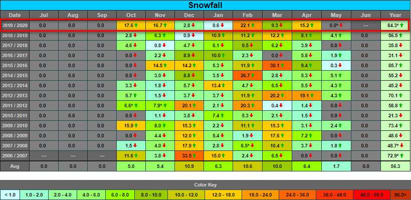
Thornton, Colorado’s 2019 / 2020 snow season report and totals. Click for larger view. (ThorntonWeather.com)
As it appears we are done with the white stuff for the season, we can now report a finally tally for snow.
Thornton’s season recorded 84.3 inches, the second most since Thornton Weather came online in 2006. Only the 2015 / 2016 season had more (85.7 inches).
The total is most notable because we never did receive a truly big storm, just a number of respectable ones. The totals were helped by big months in October, November and February which overcame a very dry December and January.
Officially, as measured at Denver International Airport, only 57.6 inches was recorded. This was a mere 1/2 inch more than Denver’s long term seasonal average of 57.1 inches.
Those numbers continue to reflect the problem with having the Mile High City’s official weather station located out at the airport where it is in a totally different microclimate whose conditions don’t reflect what the metro area really sees.
For comparison, the site at Stapleton closest to where Denver’s records were recorded for 57 years before the move to DIA saw 71.4 inches of snow this season.
Colorado’s famously highly variable weather seems to showcase itself during the month of May when a variety of weather conditions can be seen.
Winter-like temperatures and snow are possible as are mid-summer like temperatures or the more typical spring severe weather.
As the month starts out in 2020 we are going to enjoy unseasonably warm conditions along with some chances for thunderstorms. Long range forecasts portend an overall warmer than normal month with equal chances of below, at or above normal precipitation.
The month can certainly bring extremes. Snow is not entirely uncommon during the month, oftentimes causing damage to newly bloomed trees. More common however is severe weather, particularly in the latter half of the month. Thunderstorms become more frequent and their associated hazards – lightning, wind, hail and tornadoes – are usual visitors.
April can be a tricky month weather-wise with everything from mild temperatures to snow to severe weather being possible. The good thing about that is that it provides plenty of chances for great photos!
April marks a transition between winter and summer for most of the country but for Denver it is especially true as we can see a stunning variety of weather.
The proverbial April showers are certainly a possibility for Denver. Snow? Tornadoes? Thunderstorms? You bet – all can happen!
Throw in our usual wildlife plus the wide variety of birds that return to the Centennial State for the spring and summer and there is a lot going on.
Slideshow updated April 30, 2020.
To learn more about how to send your photo to us for inclusion in the slideshow, see below the slideshow.
Showcasing images captured by ThorntonWeather.com readers as well as some of our own, our monthly slideshow covers the entire gamut of weather-related imagery.
Sunsets, sunrises, wildlife and of course every type of weather condition are vividly depicted in images captured from yours and our cameras.
[flickr_set id=”72157713831009542″]
What is missing in the slideshow above? Your photo!
Our monthly photo slideshow is going to feature images that we have taken but more importantly images that you have captured. The photos can be of anything even remotely weather-related.
Landscapes, current conditions, wildlife, pets, kids. Whimsical, newsy, artsy. Taken at the zoo, some other area attraction, a local park, a national park or your backyard. You name it, we want to see and share it!
Images can be taken in Thornton, Denver or anywhere across the extraordinary Centennial State. We’ll even take some from out of state if we can tie it to Colorado somehow.
We’ll keep the criteria very open to interpretation with just about any image eligible to be shown in our slideshows.
What do you win for having your image in our slideshow? We are just a ‘mom and pop’ outfit and make no money from our site so we really don’t have the means to provide prizes. However you will have our undying gratitude and the satisfaction that your images are shared on the most popular website in Thornton.
To share you images with us and get them included in the slideshow just email them to us or share them with ThorntonWeather.com on any of the various social media outlets. Links are provided below.
Following yesterday’s snowstorm, cold air settled in and resulted in our fifth broken cold temperature record of the week.
As measured at Denver International Airport, the low temperature in Denver fell to 12 degrees this morning. That breaks the record low temperature for April 17th of 13 degrees set in 1901.
Today’s record cold is the fifth record set this week:
April 13 – Record low temperature of 15 degrees (17 degrees, 1933)
April 13 – Record low maximum temperature of 25 degrees (27 degrees, 1933)
April 14 – Record low temperature of 11 degrees (15 degrees, 1933)
April 16 – Record low temperature of 19 degrees (22 degrees, 2013 and previous years)
April 17 – Record low temperature of 12 degrees (13 degrees, 1901)
As measured at Denver International Airport, the low temperature in Denver dropped to 19 degrees. The reading easily bested the previous record low temperature for April 16th of 22 degrees last set in 2013.
When the cold of the past 36 hours or so is called “unprecedented”, that is a very accurate statement as Denver has seen three cold temperature records fall.
The latest record set came this morning when the low temperature in Denver as measured at Denver International Airport dropped to 11 degrees. That shatters the previous record low temperature for the date of 15 degrees set in 1933. Thornton stayed warmer but still in record-setting territory with a low of 14 degrees.
A second cold temperature record of the day has fallen.
The high temperature in Denver as measured at Denver International Airport only reached 25 degrees today. That breaks the previous record low maximum for the date of 27 degrees set in 1933. Here in Thornton we were just a touch “warmer” with a high of 26 degrees.
 Extreme weather can occur during in month in Colorado we well know. June however is when traditional spring severe weather arrives in the state oftentimes with hail, damaging wind and tornadoes.