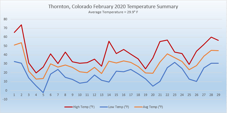
Certainly when you look back on February 2020, you probably will remember it as being cold and snowy. That indeed is true, as the numbers show, however that really only pertained to the first half of the month. The latter part was far more on par with what we expect to see.
The month did start out quite warm as we saw temperature readings well above normal on the first and second. The third, however, brought about significant changes and an end to the warmth that had carried over from January.
Several storm systems moved through over the next 10 days, bringing significantly colder temperatures and regular doses of snow. Indeed, 8 of the first 12 days of the month brought measurable snowfall. Into the third week of the month it appeared we were on pace for one of the coldest Februarys on record.
Things changed again on the 21st and five of the last nine days of the month brought warmer than normal temperatures. This was enough to drive up our average temperature which, while it did come in well below normal, was not in record-setting territory.
Thornton’s average temperature for the month came in at 29.9 degrees. This was a good ways below Denver’s long term average for February of 32.5 degrees. Out at Denver International Airport where the Mile High City’s official measurements are taken, it actually was colder with an average of 28.1 degrees.
Our temperatures ranged from a high of 73.7 degrees on the 2nd down to a low of -2.2 degrees on the morning of the 5th. Out at DIA, they saw their warmest and coldest temperatures of 74 degrees and -5 degrees on the same dates.
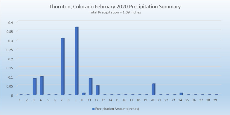
Precipitation came in well above the Denver average for the month of 0.37 inches. Thornton recorded 1.09 inches while Denver measured 0.88 inches.
Snow was of course notable for the first half of the month and drove the monthly totals. On average, Denver receives 5.7 inches in February. Thornton far surpassed that with 22.1 inches and Denver did as well with 16.5 inches of the white stuff.
Click here to view Thornton’s February 2020 climate report.
CLIMATE REPORT
NATIONAL WEATHER SERVICE DENVER/BOULDER CO
717 AM MST SUN MAR 1 2020

...................................

...THE DENVER CO CLIMATE SUMMARY FOR THE MONTH OF FEBRUARY 2020...

CLIMATE NORMAL PERIOD 1981 TO 2010
CLIMATE RECORD PERIOD 1872 TO 2020

WEATHER         OBSERVED          NORMAL  DEPART  LAST YEAR`S
                 VALUE   DATE(S)  VALUE   FROM    VALUE  DATE(S)
                                          NORMAL
................................................................
TEMPERATURE (F)
RECORD
 HIGH              80   02/10/2017
 LOW              -25   02/01/1951
                        02/08/1936
HIGHEST            74   02/02        66       8       65  02/03
LOWEST             -5   02/05                -4      -11  02/07
                        02/04
AVG. MAXIMUM     39.9              46.2    -6.3     40.8
AVG. MINIMUM     16.3              18.9    -2.6     15.3
MEAN             28.1              32.5    -4.4     28.0
DAYS MAX >= 90      0               0.0     0.0        0
DAYS MAX <= 32     10               3.9     6.1        8
DAYS MIN <= 32     28              26.9     1.1       26
DAYS MIN <= 0 2 1.3 0.7 3 PRECIPITATION (INCHES) RECORD MAXIMUM 2.01 1934 MINIMUM 0.01 1970 TOTALS 0.88 0.37 0.51 0.72 DAILY AVG. 0.03 0.01 0.02 0.03 DAYS >= .01         9               5.3     3.7        6
DAYS >= .10         4               0.7     3.3        3
DAYS >= .50         0               0.0     0.0        0
DAYS >= 1.00        0               0.0     0.0        0

GREATEST
 24 HR. TOTAL    0.19     02/12

SNOWFALL (INCHES)
TOTALS           16.5               5.7             13.4  2019
RECORD           22.4      2015

DEGREE_DAYS
HEATING TOTAL    1063               908     155     1029
 SINCE 7/1       4499              4468      31     4417
COOLING TOTAL       0                 0       0        0
 SINCE 1/1          0                 0       0        0

FREEZE DATES
RECORD
 EARLIEST     09/08/1962
 LATEST       06/08/2007
EARLIEST                        10/07
LATEST                          05/05
.................................................................

WIND (MPH)
AVERAGE WIND SPEED              10.3
RESULTANT WIND SPEED/DIRECTION   2/212
HIGHEST WIND SPEED/DIRECTION    40/350    DATE  02/25
HIGHEST GUST SPEED/DIRECTION    54/350    DATE  02/25

SKY COVER
POSSIBLE SUNSHINE (PERCENT)   MM
AVERAGE SKY COVER           0.60
NUMBER OF DAYS FAIR            8
NUMBER OF DAYS PC             13
NUMBER OF DAYS CLOUDY          8

AVERAGE RH (PERCENT)     64

-  INDICATES NEGATIVE NUMBERS.
R  INDICATES RECORD WAS SET OR TIED.
MM INDICATES DATA IS MISSING.
T  INDICATES TRACE AMOUNT.