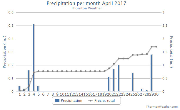
The month of April had a bit of a mixed bag for Thornton. While we saw temperatures above normal and snowfall below normal, precipitation actually ended up right near Denver’s long term average.
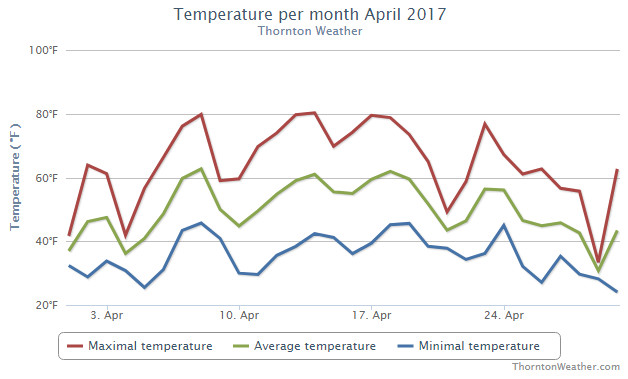
We started out cool on the first day of the month, warmed up for two days, then were delivered our first snowfall of the month on the fourth day. From there we saw a string of above normal temperatures, some far above, that lasted almost uninterrupted for two weeks.
Some rain finally fell for the three days beginning the 20th and temperatures cooled a bit. Then, on the 28th, we received our second and final snowfall of the month and followed it up with a very cold day before rebounding on the final day of the month.
Thornton saw an average temperature during April 2017 of 49.6 degrees. This was a good ways above Denver’s long term average for the month of 47.4 degrees. Out at the airport, they were cooler with an average of 48.9 degrees.
Thornton’s temperatures ranged from a maximum of 80.3 degrees on the 14th down to a low of 24.1 degrees on the morning of the 30th. Denver saw similar extremes of 79 degrees, also on the 14th, and a low of 24 degrees on the 10th.
In terms of precipitation, Denver averages 1.71 inches during April. Thornton was right there with the average at 1.70 inches in our rain bucket. At DIA, things were quite a bit drier with only 0.98 inches being recorded.
Snowfall lagged behind average for the month, especially at the average. Denver recorded only 2.5 inches officially while here in Thornton we came in at 5.8 inches. Once again this highlights the problems with having Denver’s official measurements kept so far from where they were taken historically and far away from population.
Click here to view Thornton’s April 2017 climate report.
From the National Weather Service:
CLIMATE REPORT
NATIONAL WEATHER SERVICE DENVER/BOULDER CO
244 AM MDT MON MAY 1 2017

...................................

...THE DENVER CO CLIMATE SUMMARY FOR THE MONTH OF APRIL 2017...

CLIMATE NORMAL PERIOD 1981 TO 2010
CLIMATE RECORD PERIOD 1872 TO 2017

WEATHER         OBSERVED          NORMAL  DEPART  LAST YEAR`S
                 VALUE   DATE(S)  VALUE   FROM    VALUE  DATE(S)
                                          NORMAL
................................................................
TEMPERATURE (F)
RECORD
 HIGH              90   04/30/1992
 LOW               -2   04/02/1975
HIGHEST            79   04/14        90     -11       77  04/23
                        04/13                             04/22
                                                          04/14
LOWEST             24   04/10        -2      26       25  04/01
AVG. MAXIMUM     63.2              61.5     1.7     59.4
AVG. MINIMUM     34.5              33.3     1.2     35.1
MEAN             48.9              47.4     1.5     47.2
DAYS MAX >= 90      0               0.0     0.0        0
DAYS MAX <= 32      1               0.3     0.7        0
DAYS MIN <= 32     15              13.0     2.0       11
DAYS MIN <= 0 0 0.0 0.0 0
PRECIPITATION (INCHES)
RECORD
 MAXIMUM 8.24 1900
 MINIMUM 0.03 1963
TOTALS 0.98 1.71 -0.73 2.56
DAILY AVG. 0.03 0.06 -0.03 0.09
DAYS >= .01        10               9.1     0.9       10
DAYS >= .10         5               4.5     0.5        6
DAYS >= .50         0               0.9    -0.9        2
DAYS >= 1.00        0               0.5    -0.5        1
GREATEST
 24 HR. TOTAL    0.22   04/29 TO 04/29           04/15 TO 04/16
                                                          04/16 TO 04/16
                                                          04/16 TO 04/16
 STORM TOTAL       MM                                 MM
 (MM/DD(HH))            MM                    04/16(00) TO 04/16(00)
                                                 04/16(00) TO 04/16(00)6
                                                 04/16(00) TO 04/16(00)6

SNOWFALL (INCHES)
RECORDS
 TOTAL             MM   MM
TOTALS            2.5               6.8

DEGREE_DAYS
HEATING TOTAL     478               529     -51      526
 SINCE 7/1       4803              5731    -928     5230
COOLING TOTAL       0                 1      -1        0
 SINCE 1/1          0                 1      -1        0

FREEZE DATES
RECORD
 EARLIEST     09/08/1962
 LATEST       06/08/2007
EARLIEST      04/01             10/07
LATEST                          05/05
.......................................................

WIND (MPH)
AVERAGE WIND SPEED              11.6
RESULTANT WIND SPEED/DIRECTION   1/121
HIGHEST WIND SPEED/DIRECTION    44/300    DATE  04/09
HIGHEST GUST SPEED/DIRECTION    56/300    DATE  04/09

SKY COVER
POSSIBLE SUNSHINE (PERCENT)   MM
AVERAGE SKY COVER           0.60
NUMBER OF DAYS FAIR            6
NUMBER OF DAYS PC             17
NUMBER OF DAYS CLOUDY          7

AVERAGE RH (PERCENT)     53

WEATHER CONDITIONS. NUMBER OF DAYS WITH
THUNDERSTORM              0     MIXED PRECIP               0
HEAVY RAIN                1     RAIN                       1
LIGHT RAIN               10     FREEZING RAIN              0
LT FREEZING RAIN          0     HAIL                       0
HEAVY SNOW                1     SNOW                       3
LIGHT SNOW                7     SLEET                      0
FOG                      10     FOG W/VIS <= 1/4 MILE      4
HAZE                      2

-  INDICATES NEGATIVE NUMBERS.
R  INDICATES RECORD WAS SET OR TIED.
MM INDICATES DATA IS MISSING.
T  INDICATES TRACE AMOUNT.