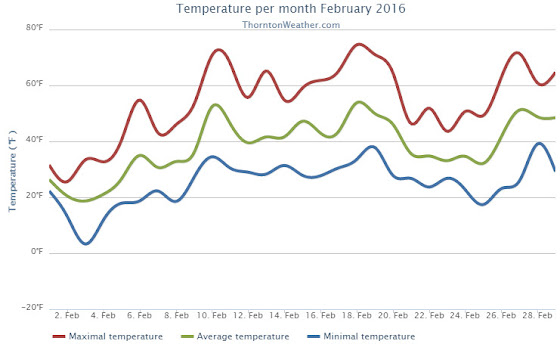
The month of February was a bit of a mixed bag of weather conditions for Thornton. While it started out cold and snowy, it finished quite warm.
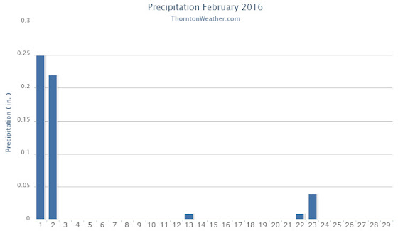
Snow and cold were the main features for the month initially as we received our biggest snowfall of the season on the 1st and 2nd. Thornton recorded a healthy 11.1 inches from the system while Denver officially saw 11.6 inches.
The white stuff and the cold with it did not last long however. Cold did linger for a few days but an extended period from the 9th to the 20th saw dry conditions and warmer than normal temperatures.
A very brief interlude then arrived cooling things down and delivering light snow on the 23rd. From there, the warm and dry conditions returned and closed out the month.
Thornton saw an average monthly temperature of 38.5 degrees for the month. Out at the airport where Denver’s official measurements are taken, the month averaged 37.8 degrees. Both were well above the historical February average of 32.5 degrees.
Temperatures in Thornton ranged from a high of 74.5 degrees on the 18th down to a low of 3.3 degrees on the morning of the 3rd. Denver’s maximum reading for the month was 73 degrees and its lowest 1 degree, both occurring on the same day as Thornton’s. The Mile High City’s reading on the 18th was a record high for the date.
In terms of precipitation, Denver averages 0.37 inches during what is usually a relatively dry month. Thornton saw 0.53 inches of liquid precip while DIA recorded 0.48 inches. For both locations, the bulk of the moisture occurred with the snowstorm that started the month.
Snowfall was well above normal for February 2016. Thornton saw 11.9 inches and Denver 11.6 inches. Average for February is 5.9 inches.
Click here to view Thornton’s February 2016 climate report.
From the National Weather Service:
CLIMATE REPORT
NATIONAL WEATHER SERVICE DENVER/BOULDER CO
1035 AM MST TUE MAR 1 2016

...................................

...THE DENVER CO CLIMATE SUMMARY FOR THE MONTH OF FEBRUARY 2016...

CLIMATE NORMAL PERIOD 1981 TO 2010
CLIMATE RECORD PERIOD 1872 TO 2016

WEATHER         OBSERVED          NORMAL  DEPART  LAST YEAR`S
                 VALUE   DATE(S)  VALUE   FROM    VALUE  DATE(S)
                                          NORMAL
................................................................
TEMPERATURE (F)
RECORD
 HIGH              77   02/28/2006
                        02/04/1890
 LOW              -25   02/01/1951
                        02/08/1936
HIGHEST            73   02/18        68       5       74  02/07
LOWEST              1   02/03         5       4       -6  02/27
AVG. MAXIMUM     52.2              46.2     6.0     46.6
AVG. MINIMUM     23.4              18.9     4.5     21.0
MEAN             37.8              32.5     5.3     33.8
DAYS MAX >= 90      0               0.0     0.0        0
DAYS MAX <= 32      3               3.9    -0.9        7
DAYS MIN <= 32     25              26.9    -1.9       24
DAYS MIN <= 0       0               1.3    -1.3        2

PRECIPITATION (INCHES)
RECORD
 MAXIMUM         2.01   1934
 MINIMUM         0.01   1970
TOTALS           0.48              0.37    0.11     1.25
DAILY AVG.       0.02                MM      MM     0.04
DAYS >= .01         2               5.3    -3.3       10
DAYS >= .10         2               0.7     1.3        5
DAYS >= .50         0               0.0     0.0        0
DAYS >= 1.00        0               0.0     0.0        0
GREATEST
 24 HR. TOTAL    0.45   02/01 TO 02/02                    02/15 TO 02/16
                                                          02/21 TO 02/21

SNOWFALL (INCHES)
RECORDS
 TOTAL           11.6               5.7
RECORD FEBRUARY  22.4                            2015

DEGREE_DAYS
HEATING TOTAL     780               908    -128      864
 SINCE 7/1       3988              4468    -480     4113
COOLING TOTAL       0                 0       0        0
 SINCE 1/1          0                 0       0        0

FREEZE DATES
RECORD
 EARLIEST     09/08/1962
 LATEST       06/08/2007
EARLIEST                        10/07
LATEST                          05/05
..................................................

WIND (MPH)
AVERAGE WIND SPEED              11.3
RESULTANT WIND SPEED/DIRECTION   3/217
HIGHEST WIND SPEED/DIRECTION    43/220    DATE  02/18
HIGHEST GUST SPEED/DIRECTION    53/230    DATE  02/18

SKY COVER
POSSIBLE SUNSHINE (PERCENT)   MM
AVERAGE SKY COVER           0.50
NUMBER OF DAYS FAIR            8
NUMBER OF DAYS PC             18
NUMBER OF DAYS CLOUDY          3

AVERAGE RH (PERCENT)     50

WEATHER CONDITIONS. NUMBER OF DAYS WITH
THUNDERSTORM              0     MIXED PRECIP               0
HEAVY RAIN                0     RAIN                       0
LIGHT RAIN                0     FREEZING RAIN              0
LT FREEZING RAIN          0     HAIL                       0
HEAVY SNOW                0     SNOW                       2
LIGHT SNOW                3     SLEET                      0
FOG                       4     FOG W/VIS <= 1/4 MILE      3
HAZE                      2

-  INDICATES NEGATIVE NUMBERS.
R  INDICATES RECORD WAS SET OR TIED.
MM INDICATES DATA IS MISSING.
T  INDICATES TRACE AMOUNT.