The month of June was a rather eventful one with wetter than normal conditions starting things out and temperatures coming in quite a ways above normal. Further, the month lived up to its reputation as Colorado’s severe weather month with numerous notable thunderstorms and a good bit of tornado activity.
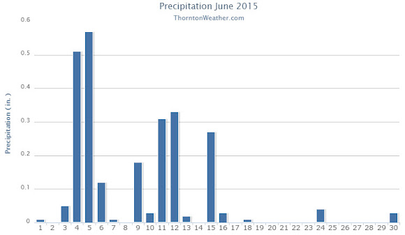
The month started out warm and dry but on the 3rd a cold front moved in cooling things down and bringing healthy shots of rain. On the 4th and 5th Thornton saw more than a half inch of rain on each day.
To our north, the 4th brought extreme weather in the form of an EF-3 tornado near Berthoud and multiple, smaller tornadoes in the Simla area to the southwest.
We then dried out a bit and warmed up but on the 9th another cold front arrived. Like the previous system, cooler temperatures and a decent shot of rain followed.
In the first 18 days of the month, Thornton saw 14 days with measurable precipitation. That however chanced for the latter third of the month as we dried out and warmed up significantly. There were still days with thunderstorms but the bulk of them seemed to just miss Thornton for the most part.
Such was the case of the 24th when extreme weather hit to our south. While we saw just a bit of rain, other areas near central Denver recorded far more and an EF-1 tornado struck from northeast Denver to northwest Aurora.
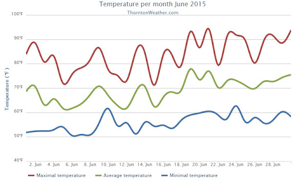
Overall Thornton’s monthly average temperature for June 2015 came in at 69.0 degrees. This was a good ways above the long term June average for Denver of 67.4 degrees. Out at the airport, the Mile High City’s official average reading was 69.5 degrees.
Temperatures in Thornton ranged from a high of 94.3 degrees on the 21st down to a low of 50.5 degrees on the morning of the 6th. Denver’s highest reading of 94 degrees came on the 30th and its lowest of 51 degrees on the 3rd.
In terms of precipitation, both Thornton and Denver recorded identical amounts in their rain buckets. The 2.53 inches of precip bested Denver’s June average of 1.98 inches by a good bit. In all, Thornton saw 16 days of measurable precipitation while Denver recorded 13.
Click here to view Thornton’s June 2015 climate report.
CLIMATE REPORT
NATIONAL WEATHER SERVICE BOULDER, CO
806 PM MDT SAT JUL 4 2015

...................................

...THE DENVER CO CLIMATE SUMMARY FOR THE MONTH OF JUNE 2015...

CLIMATE NORMAL PERIOD 1981 TO 2010
CLIMATE RECORD PERIOD 1872 TO 2015

WEATHER         OBSERVED          NORMAL  DEPART  LAST YEAR`S
                 VALUE   DATE(S)  VALUE   FROM    VALUE  DATE(S)
                                          NORMAL
................................................................
TEMPERATURE (F)
RECORD
 HIGH             105   06/26/2012
                        06/25/2012
                        54/01/2206
 LOW               30   06/02/1951
HIGHEST            94   06/30                         94  06/26
LOWEST             51   06/03                         42  06/15
AVG. MAXIMUM     82.9              82.4     0.5     83.4
AVG. MINIMUM     56.1              52.3     3.8     51.2
MEAN             69.5              67.4     2.1     67.3
DAYS MAX >= 90      6               7.9    -1.9        6
DAYS MAX <= 32      0               0.0     0.0        0
DAYS MIN <= 32      0               0.0     0.0        0
DAYS MIN <= 0       0               0.0     0.0        0

PRECIPITATION (INCHES)
RECORD
 MAXIMUM         4.96   1882
 MINIMUM            T   1890
TOTALS           2.53              1.98    0.55     1.82
DAILY AVG.       0.08              0.07    0.01     0.06
DAYS >= .01        13               8.4     4.6        9
DAYS >= .10         5               4.6     0.4        5
DAYS >= .50         2               1.4     0.6        1
DAYS >= 1.00        0               0.3    -0.3        0
GREATEST
 24 HR. TOTAL    0.99   06/05 TO 06/05           06/27 TO 06/27

SNOWFALL (INCHES)
RECORDS
 TOTAL            0.0
TOTALS            0.0               0.0

DEGREE_DAYS
HEATING TOTAL      11                62     -51       30
 SINCE 7/1       5583              6058    -475     6004
COOLING TOTAL     154               133      21      106
 SINCE 1/1        158               155       3      127

FREEZE DATES
RECORD
 EARLIEST     09/08/1962
 LATEST       06/08/2007
EARLIEST                        10/07
LATEST                          05/05
........................................................

WIND (MPH)
AVERAGE WIND SPEED              9.0
RESULTANT WIND SPEED/DIRECTION   2/167
HIGHEST WIND SPEED/DIRECTION    36/160    DATE  06/24
HIGHEST GUST SPEED/DIRECTION    47/160    DATE  06/24

SKY COVER
POSSIBLE SUNSHINE (PERCENT)   MM
AVERAGE SKY COVER           0.50
NUMBER OF DAYS FAIR            6
NUMBER OF DAYS PC             22
NUMBER OF DAYS CLOUDY          2

AVERAGE RH (PERCENT)     61

WEATHER CONDITIONS. NUMBER OF DAYS WITH
THUNDERSTORM             16     MIXED PRECIP               0
HEAVY RAIN                4     RAIN                       5
LIGHT RAIN               16     FREEZING RAIN              0
LT FREEZING RAIN          0     HAIL                       3
HEAVY SNOW                0     SNOW                       0
LIGHT SNOW                0     SLEET                      1
FOG                       6     FOG W/VIS <= 1/4 MILE      1
HAZE                      3

-  INDICATES NEGATIVE NUMBERS.
R  INDICATES RECORD WAS SET OR TIED.
MM INDICATES DATA IS MISSING.
T  INDICATES TRACE AMOUNT.