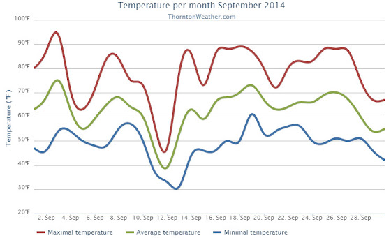
Thornton’s September this year was relatively benign and lacking much drama although it was a bit of a rollercoaster. Temperatures had their large swings and we saw a couple of days with healthy precipitation.
The month started out slightly cooler than normal on the first but then warmed over the next couple of days to a high of 93.8 degrees on the third.
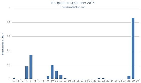
Low pressure and a cold front brought an end to the heat and three days of cooler than normal temperatures arrived. Two of those three days combined to deliver more than a half inch of precipitation.
Warmer and drier weather returned for a few days before a more potent cold front pushed in. The 11th and 12th of the month brought our coldest days of the month. Low temperatures became quite chilly dropping to below freezing on the morning of the 13th as the system moved out.
Some rain fell on those days and while Denver recorded a trace of snow on the morning of the 12th, none was seen in Thornton.
We then rebounded nicely with 10 of the next 11 days seeing high temperatures above 80 degrees, many of those in the mid to upper 80s.
Things cooled down for the last three days as a strong system moved through. We recorded a significant 0.86 inches of rain on the 29th.
Thornton’s overall average temperature for the month was 62.6 degrees. This was a bit below the long term Denver average of 63.4 degrees. Out at the airport, it was as usual warmer with an average of 64.8 degrees.
Temperatures ranged from a high of 93.8 degrees on the 3rd down to a chilly low of 30.9 degrees on the 13th. Denver’s warmest day matched ours on the 3rd with a reading of 94 degrees while the Mile High City’s coldest reading of 33 degrees came on the 12th.
Denver saw one temperature record during the month. The record high minimum for September 25th was set with a reading of 56 degrees. This tied the record for the date last set in 1981.
In terms of precipitation, Thornton recorded 1.89 inches in the rain bucket for the month. Denver saw 1.79 inches. Both were well above Denver’s September average of 0.96 inches.
A daily rainfall record for Denver was set on the 29th when 1.01 inches fell at the airport. The old record of 0.96 inch for the date was set in 1959.
Click here to view Thornton’s September 2014 climate report.
...THE DENVER CO CLIMATE SUMMARY FOR THE MONTH OF SEPTEMBER 2014...

CLIMATE NORMAL PERIOD 1981 TO 2010
CLIMATE RECORD PERIOD 1872 TO 2014

WEATHER         OBSERVED          NORMAL  DEPART  LAST YEAR`S
                 VALUE   DATE(S)  VALUE   FROM    VALUE  DATE(S)
                                          NORMAL
................................................................
TEMPERATURE (F)
RECORD
 HIGH              97   09/06/2013
                        09/05/2013
                        09/04/1995
 LOW               17   09/29/1985
HIGHEST            94   09/03        91       3       97  09/06
                                                          09/05
LOWEST             33   09/12        35      -2       38  09/28
AVG. MAXIMUM     78.9              78.5     0.4     78.6
AVG. MINIMUM     50.6              48.3     2.3     54.2
MEAN             64.8              63.4     1.4     66.4
DAYS MAX >= 90      2               3.4    -1.4        7
DAYS MAX <= 32      0               0.0     0.0        0
DAYS MIN <= 32      0               0.8    -0.8        0
DAYS MIN <= 0       0               0.0     0.0        0
PRECIPITATION (INCHES)
RECORD
  MAXIMUM         5.61   2013
  MINIMUM            T   1892                         1944
TOTALS           1.79              0.96    0.83     5.61
DAILY AVG.       0.06              0.03    0.03     0.19
DAYS >= .01         9               6.5     2.5       10
DAYS >= .10         4               3.3     0.7       10
DAYS >= .50         1               0.6     0.4        3
DAYS >= 1.00        1               0.1     0.9        2
GREATEST
 24 HR. TOTAL    1.01   09/29 TO 09/29           09/14 TO 09/15

SNOWFALL (INCHES)
RECORDS
 TOTAL             17.2   1991
TOTALS              T               1.3     -1.3       0

DEGREE_DAYS
HEATING TOTAL      91               125     -34       83
 SINCE 7/1         98               141     -43       83
COOLING TOTAL      88                76      12      133
 SINCE 1/1        701               764     -63      999

FREEZE DATES
RECORD
 EARLIEST     09/08/1962
 LATEST       06/08/2007
EARLIEST                        10/07
LATEST                          05/05
.....................................................

WIND (MPH)
AVERAGE WIND SPEED              9.4
RESULTANT WIND SPEED/DIRECTION   3/186
HIGHEST WIND SPEED/DIRECTION    33/350    DATE  09/09
HIGHEST GUST SPEED/DIRECTION    40/360    DATE  09/09

SKY COVER
POSSIBLE SUNSHINE (PERCENT)   MM
AVERAGE SKY COVER           0.50
NUMBER OF DAYS FAIR           13
NUMBER OF DAYS PC             11
NUMBER OF DAYS CLOUDY          6

AVERAGE RH (PERCENT)     55

WEATHER CONDITIONS. NUMBER OF DAYS WITH
THUNDERSTORM              3     MIXED PRECIP               0
HEAVY RAIN                1     RAIN                       6
LIGHT RAIN                9     FREEZING RAIN              0
LT FREEZING RAIN          0     HAIL                       0
HEAVY SNOW                0     SNOW                       0
LIGHT SNOW                2     SLEET                      0
FOG                       9     FOG W/VIS <= 1/4 MILE      1
HAZE                      3

-  INDICATES NEGATIVE NUMBERS.
R  INDICATES RECORD WAS SET OR TIED.
MM INDICATES DATA IS MISSING.
T  INDICATES TRACE AMOUNT.