June 2014 top shots: Monthly photo slideshow

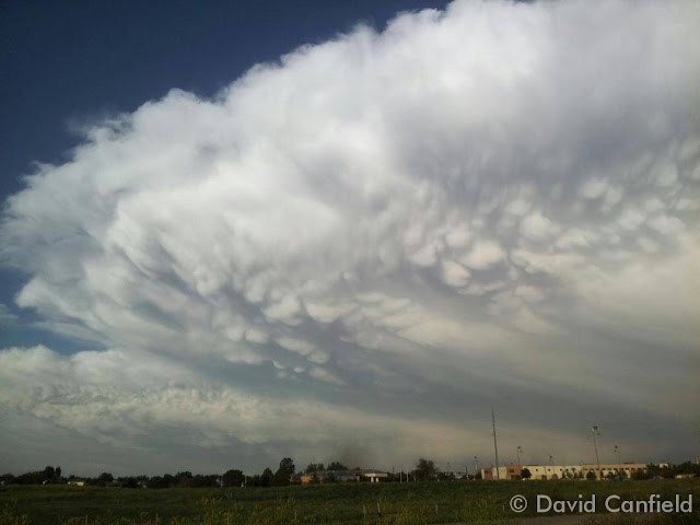
Impressive thunderstorms are a hallmark of Colorado's June weather. (David Canfield)
Impressive thunderstorms are a hallmark of Colorado’s June weather. (David Canfield)

The month of June typically sees springtime severe weather reach its height of activity in northeastern Colorado.

This affords the opportunity to capture extraordinary images of amazing weather phenomena from monstrous supercell thunderstorms to heavy rain, hail and even tornadoes.

  • Slideshow updated June 30, 2014

Showcasing images captured by ThorntonWeather.com readers as well as some of our own, our monthly slideshow covers the entire gamut of weather-related imagery.

Sunsets, sunrises, wildlife and of course every type of weather condition are vividly depicted.  June brings some very dynamic weather and the photos are a great way to see the stunning variety.

To learn more about how to send your photo to us for inclusion in the slideshow, see below the slideshow.

Click the play button below and sit back and enjoy the images.

What is missing in the slideshow above?  Your photo!

Our monthly photo slideshow is going to feature images that we have taken but more importantly images that you have captured.  The photos can be of anything even remotely weather-related.

Landscapes, current conditions, wildlife, pets, kids.  Whimsical, newsy, artsy.  Taken at the zoo, some other area attraction, a local park, a national park or your backyard.  You name it, we want to see and share it!

Images can be taken in Thornton, Denver or anywhere across the extraordinary Centennial State.  We’ll even take some from out of state if we can tie it to Colorado somehow.

We’ll keep the criteria very open to interpretation with just about any image eligible to be shown in our slideshows.

What do you win for having your image in our slideshow?  We are just a ‘mom and pop’ outfit and make no money from our site so we really don’t have the means to provide prizes.  However you will have our undying gratitude and the satisfaction that your images are shared on the most popular website in Thornton.

To share you images with us and get them included in the slideshow just email them to us or share them with ThorntonWeather.com on any of the various social media outlets.  Links are provided below.

So come on, get those camera’s rolling!

May 2014 weather recap: Temps near normal, a good bit wetter than normal

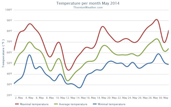
The month of May was a relatively benign, uneventful month in terms of the weather in Thornton. Average temperatures were right on par with normal while precipitation was generous.

We started out the month with warming temperatures and by the third we were seeing highs in the 80s.  This only lasted a few days before cooler than normal temperatures settled in for a 10 day period.

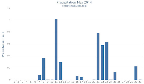
It was during that period that we recorded precipitation for six straight days.  This included a good shot of snow on the 11th and 12th.

Temperatures bounced back on the 18th and 19th with highs above 80 degrees but then settled down again to predominantly cooler than normal conditions for the next week.  The period from the 20th to the 25th also saw a return to wet conditions.

Warmer and dry conditions returned for a few days and then we closed out the month with cooler temperatures and some more rain.

Thornton finished the month with an average temperature of 56.9 degrees.  This was just a hair lower than Denver’s May average of 57.1 degrees.  The Mile High City’s average temperature came in warmer at 57.5 degrees.

The hottest temperature recorded occurred on the 29th with a reading of 88.7 degrees.  The coldest temperature of 28.5 degrees was on the 14th.  Denver’s warmest reading was 85 degrees on the 4th and its coldest of 30 degrees was on the 12th.

In terms of precipitation, Thornton saw a healthy 4.26 inches of liquid precipitation.  This was well above the May average of 2.12 inches.  Similarly, Denver saw above normal precipitation with a reading of 3.51 inches.

Snow fell on two days and totaled 4.3 inches in Thornton. Out at DIA, only 1.1 inches was recorded.  Average snowfall for May in Denver is 1.1 inches.

Click here to view Thornton’s May 2014 climate report.

http://www.thorntonweather.com/climatedataout52014.html

The Thornton, Colorado temperature summary for May 2014. (ThorntonWeather.com)


The Thornton, Colorado precipitation summary for May 2014. (ThorntonWeather.com)
CLIMATE REPORT
NATIONAL WEATHER SERVICE BOULDER, CO
642 AM MDT SUN JUN 1 2014
 
...................................
 
...THE DENVER CO CLIMATE SUMMARY FOR THE MONTH OF MAY 2014...
 
CLIMATE NORMAL PERIOD 1981 TO 2010
CLIMATE RECORD PERIOD 1872 TO 2014
 
WEATHER         OBSERVED          NORMAL DEPART LAST YEAR`S
                 VALUE   DATE(S) VALUE   FROM    VALUE DATE(S)
                                          NORMAL
................................................................
TEMPERATURE (F)
RECORD
 HIGH              95   05/26/1942
 LOW               19   05/02/2013
                        05/03/1907
HIGHEST            87   05/28        95      -8       88 05/17
                        05/29
LOWEST             30   05/12        19      11      19 05/02
AVG. MAXIMUM     70.6              71.5    -0.9     71.7
AVG. MINIMUM     44.5              42.7     1.8     44.1
MEAN             57.5              57.1     0.4     57.9
DAYS MAX >= 90      0               0.8    -0.8        0
DAYS MAX <= 32      0               0.0     0.0        0
DAYS MIN <= 32      4               1.9     2.1        4
DAYS MIN <= 0       0               0.0     0.0        0
 
PRECIPITATION (INCHES)
RECORD
 MAXIMUM         8.57   1876
 MINIMUM         0.06   1974
TOTALS           3.51              2.12    1.39     0.82
DAILY AVG.       0.11              0.07    0.04     0.03
DAYS >= .01        13               9.4     3.6        7
DAYS >= .10         6               4.8     1.2        3
DAYS >= .50         3               1.2     1.8        0
DAYS >= 1.00        1               0.2     0.8        0
GREATEST
 24 HR. TOTAL    1.39   05/20 TO 05/21              0.33 05/07 TO 05/08
 
SNOWFALL (INCHES)
TOTALS            1.1               1.1              3.4
 
DEGREE_DAYS
HEATING TOTAL     244               265     -21      253
 SINCE 7/1       5974              5996     -22     6055
COOLING TOTAL      21                21       0       42
 SINCE 1/1         21                22      -1       42
 
FREEZE DATES
RECORD
 EARLIEST     09/08/1962
 LATEST       06/08/2007
EARLIEST                        10/07
LATEST                          05/05
.........................................................
 
WIND (MPH)
AVERAGE WIND SPEED              10.6
RESULTANT WIND SPEED/DIRECTION   1/181
HIGHEST WIND SPEED/DIRECTION    37/330    DATE 05/21
HIGHEST GUST SPEED/DIRECTION    42/330    DATE 05/21
 
SKY COVER
POSSIBLE SUNSHINE (PERCENT)   MM
AVERAGE SKY COVER           0.70
NUMBER OF DAYS FAIR            3
NUMBER OF DAYS PC             18
NUMBER OF DAYS CLOUDY         10
 
AVERAGE RH (PERCENT)     55
 
WEATHER CONDITIONS. NUMBER OF DAYS WITH
THUNDERSTORM              0     MIXED PRECIP               0
HEAVY RAIN                2     RAIN                       6
LIGHT RAIN               17     FREEZING RAIN              0
LT FREEZING RAIN          1     HAIL                       1
HEAVY SNOW                0     SNOW                       2
LIGHT SNOW                2     SLEET                      1
FOG                      11     FOG W/VIS <= 1/4 MILE      3
HAZE                      3
 
- INDICATES NEGATIVE NUMBERS.
R INDICATES RECORD WAS SET OR TIED.
MM INDICATES DATA IS MISSING.
T INDICATES TRACE AMOUNT.

Thornton’s June weather preview: Severe weather takes to the forefront

Thornton's June weather preview.Extreme weather can occur during in month in Colorado we well know.  June however is when traditional spring severe weather arrives in the state oftentimes with hail, damaging wind and tornadoes.
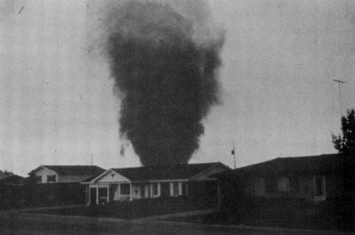
Over 40 percent of the tornadoes that occur in Colorado happen during the month of June.  Far more common are thunderstorms with hail and wind, each responsible for extensive damage each year.

While severe weather is common, so too are brilliantly sunny and mild days as we close out spring and enter summer.  If you are looking for cold, it isn’t likely but it is possible as the Denver area has seen freezing temperatures and yes, even snow, during the month.

Read more about Thornton and Denver’s June weather and a look ahead at this year.

A look back at the most destructive tornado in Denver metro history: June 3, 1981 Thornton, Colorado

June 3, 1981 - An F2 tornado rips through the heart of Thornton, Colorado. (NCAR)
June 3, 1981 – An F2 tornado rips through the heart of Thornton, Colorado. See more images in the slideshow below.(NCAR)

June 3, 1981 appeared to be a pretty typical late spring day in the Denver metro area.  Afternoon thunderstorms though would become a ‘perfect storm’ and soon the city of Thornton would find itself witness to a tornado that would go down in the Denver weather history books.

Five tornadoes would strike that day but one would become the most infamous.  The Thornton tornado would tear through what was then the heart of the city damaging homes and businesses and sending many residents to the hospital.

The twister initially touched down at 2:43 p.m. and ripped across 2 miles of the city.  The tornado was rated an F2 on the Fujita Scale packing winds up to 157mph.

Following is a description of the event from the National Weather Service and below that is a slideshow of some photos of the event we have accumulated.

In 1981…severe thunderstorms produced tornadoes over metro Denver.  The first tornado touched down at the intersection of Alameda Ave. And Sheridan Blvd.  The twister moved north along Sheridan Blvd….damaging businesses…apartment buildings…homes…and vehicles.  Over ten homes were unroofed.  The roof of one landed in the middle of a neighborhood park.  At least 10 mobile homes were wrecked.

The tornado curved to the northeast into northwest Denver… Hopping up and down in several places.  Very strong winds outside the actual funnel caused 20 to 30 thousand dollars in damage in downtown Denver.  The third floor of one old building was demolished.  No major injuries were reported from the tornado…although several people were hurt slightly in traffic accidents on Sheridan Blvd. in the confusion caused by the storm.  Damage in Lakewood alone was estimated at 200 thousand dollars. 

At the same time… The worst tornado to ever hit metro Denver struck Thornton. Coming from the same thunderstorm that spawned the Denver twister…the Thornton tornado tore a swath through the heart of the city.  87 homes were destroyed…110 others damaged at least moderately.  In all…600 homes in a 100 block area sustained some damage.  The twister also hit shopping centers…several restaurants…and other buildings. Seven of the 42 injured were considered serious.  The storm was strong enough to snap lamp posts in half and drive a 6- inch slab of wood 2 feet into the ground.  Damage was estimated at up to 50 million dollars. 

The same storm that struck Thornton produced another damaging tornado that touched down in the northwest section of Fort Lupton.  This twister damaged 16 homes and numerous cars and campers. Two children were slightly injured when the car they were in was knocked about and its windows shattered by the storm.  The twister also damaged two commercial buildings.  Damage was very spotty…and observers said the storm hopped up and down at least 3 times.  Dollar damage was estimated at 500 thousand dollars. 

The thunderstorm complex that produced 3 damaging tornadoes also dropped large hail which damaged many cars over northwest Denver.  One to 2 inches of rain fell in less than an hour…flooding a mobile home park with 3 to 4 feet of water on the northwest edge of Denver.  The high water damaged about half of the 392 homes in the park.  Local flooding was also reported in other areas across metro Denver.  A tornado was also sighted near Franktown…but caused no damage.  A thunderstorm wind gust to 52 mph was recorded at Stapleton International Airport.

Also see: