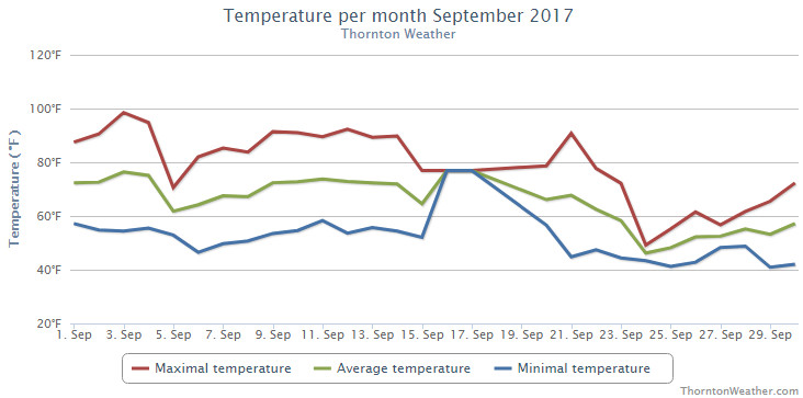
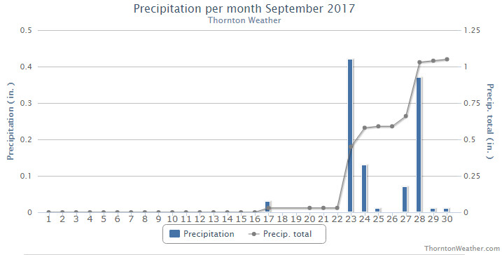
The month of September 2017 saw significant differences between the start and the end. The first two-thirds of the month were extraordinarily dry with temperatures well above normal. The last 10 days brought a big change though with damp conditions and much cooler conditions.
High pressure dominated the region for the first few weeks of the month. During this period when we normally see cooler temperatures, we instead saw highs oftentimes at or above 90 degrees and a couple of record high readings. Additionally, it was exceedingly dry with Thornton only received 0.03 inches of precipitation through the first 22 days of the month.
Big changes arrived and the last nine days of the month stood it stark contrast to the rest of September. Low pressure and a series of disturbances brought much cooler temperatures and much-needed precipitation, including snowfall in the high country. Seven out of the last eight days saw below normal high temperature readings and enough precipitation fell to push us to just above normal.
Thornton’s overall average temperature for the month came in at 62.4 degrees. This was a full degree cooler than Denver’s long term September average of 63.4 degrees. Out at DIA where Denver’s official measurements are taken, it was a good bit warmer with an average temperature of 65.1 degrees.
Temperatures in Thornton ranged from a high of 98.5 degrees on the third and a low of 40.9 degrees on the morning of the 29th. Denver saw their high of 97 degrees on the third as well and their coldest reading of 40 degrees on the 20th.
Two record high temperatures were officially set or tied for the Mile High City. The high temperature of 97 degrees on the third tied the record high for the date. A reading of 92 degrees on the 21st set a new record high for that date.
In terms of precipitation, Denver averages 0.96 inches during September. Thornton tallied 1.05 inches in the rain bucket while Denver bested us with 1.26 inches.
Click here to view Thornton’s September 2017 climate report.
From the National Weather Service:
CLIMATE REPORT
NATIONAL WEATHER SERVICE DENVER/BOULDER CO
244 AM MDT SUN OCT 1 2017

...................................

...THE DENVER CO CLIMATE SUMMARY FOR THE MONTH OF SEPTEMBER 2017...

CLIMATE NORMAL PERIOD 1981 TO 2010
CLIMATE RECORD PERIOD 1872 TO 2017

WEATHER         OBSERVED          NORMAL  DEPART  LAST YEAR`S
                 VALUE   DATE(S)  VALUE   FROM    VALUE  DATE(S)
                                          NORMAL
................................................................
TEMPERATURE (F)
RECORD
 HIGH              97   09/03/2017
                        09/06/2013
                        09/05/2013
 LOW               17   09/29/1985
HIGHEST            97R  09/03        91       6       93  09/05
LOWEST             40   09/20        35       5       37  09/10
AVG. MAXIMUM     79.0              78.5     0.5     82.3
AVG. MINIMUM     51.3              48.3     3.0     49.7
MEAN             65.1              63.4     1.7     66.0
DAYS MAX >= 90      9               3.4     5.6        6
DAYS MAX <= 32      0               0.0     0.0        0
DAYS MIN <= 32      0               0.8    -0.8        0
DAYS MIN <= 0 0 0.0 0.0 0 PRECIPITATION (INCHES) RECORD MAXIMUM 5.61 2013 MINIMUM T 1892 1944 TOTALS 1.26 0.96 0.30 0.28 DAILY AVG. 0.04 0.03 0.01 0.01 DAYS >= .01         6               6.5    -0.5        4
DAYS >= .10         2               3.3    -1.3        1
DAYS >= .50         1               0.6     0.4        0
DAYS >= 1.00        0               0.1    -0.1        0
GREATEST
 24 HR. TOTAL    0.83   09/23 TO 09/23           09/12 TO 09/12

SNOWFALL (INCHES)
RECORDS
 TOTAL             0.0
TOTALS            0.0               1.3

DEGREE_DAYS
HEATING TOTAL     122               125      -3       64
 SINCE 7/1        130               141     -11       79
COOLING TOTAL     131                76      55       99
 SINCE 1/1        880               764     116      861

FREEZE DATES
RECORD
 EARLIEST     09/08/1962
 LATEST       06/08/2007
EARLIEST                        10/07
LATEST                          05/05
...................................................

WIND (MPH)
AVERAGE WIND SPEED              9.6
RESULTANT WIND SPEED/DIRECTION   2/165
HIGHEST WIND SPEED/DIRECTION    40/020    DATE  09/19
HIGHEST GUST SPEED/DIRECTION    48/030    DATE  09/19

SKY COVER
POSSIBLE SUNSHINE (PERCENT)   MM
AVERAGE SKY COVER           0.50
NUMBER OF DAYS FAIR            9
NUMBER OF DAYS PC             15
NUMBER OF DAYS CLOUDY          6

AVERAGE RH (PERCENT)     48

WEATHER CONDITIONS. NUMBER OF DAYS WITH
THUNDERSTORM              0     MIXED PRECIP               0
HEAVY RAIN                1     RAIN                       1
LIGHT RAIN               10     FREEZING RAIN              0
LT FREEZING RAIN          0     HAIL                       0
HEAVY SNOW                0     SNOW                       0
LIGHT SNOW                0     SLEET                      0
FOG                       8     FOG W/VIS <= 1/4 MILE      1
HAZE                     10

-  INDICATES NEGATIVE NUMBERS.
R  INDICATES RECORD WAS SET OR TIED.
MM INDICATES DATA IS MISSING.
T  INDICATES TRACE AMOUNT.