Cold, snow and wind mark this week in our look back at Denver weather history. Numerous notable events including a period of 69 hours when the temperatures remained below zero – the fourth longest on record.
30-7
In 1985…a cold front on the 29th produced a protracted cold spell as arctic air remained entrenched across metro Denver. While the only daily temperature record set was a low maximum reading of 2 degrees on February 3rd…minimum temperatures plunged well below zero on 9 consecutive days. The coldest readings were 15 degrees below zero on January 31st and 14 degrees below zero on February 5th.
31-8
In 1963…warm weather that began with the strong Chinook winds on the 31st and 1st continued through the 8th. Maximum temperatures through the period ranged from 52 degrees on the 2nd to 76 degrees on the 5th…which was a new record high for that date.
31-12
In 1899…a protracted cold spell lasted almost two weeks. Low temperatures plunged below zero on all days but February 9th with a reading of 6 degrees. The coldest low temperature of 22 degrees below zero on February 6th was a record low for the date. Low temperatures of 20 degrees below zero occurred on both February 11th and 12th… But only the 11th remains as the record minimum for the date. High temperature of only 5 degrees below zero on February 11th was a record low maximum for the date. High temperatures climbed to only zero degrees on both February 2nd and 3rd…but were not records. Intermittent light snow or flurries fell during the period. The most snowfall…2.0 inches…occurred on February 2nd.
1-6
In 1989…one of the century’s worst doses of winter weather ravaged the entire state. Bitterly frigid weather moved into metro Denver on the 1st as snow buried many sections of the state. In metro Denver where 3 to 6 inches of snow fell…blowing snow and resultant poor visibilities caused a 46-car pile-up on I-25 in the middle of the city on the 4th. During the period…2 to 3 hour delays were common at Stapleton International Airport where snowfall from the storm totaled 4.3 inches and northeast winds gusted to 30 mph on the 1st. Intense cold accompanied the storm. Temperatures in Denver stayed below zero continuously for the best part of 3 days (3rd…4th…5th)…for a total of 69 hours. This is the fourth longest sub-zero period on record. Wind chill temperatures reached 50 degrees below zero. The mercury dipped to 24 degrees below zero on the 5th…setting a record for the date. This was the city’s coldest temperature in over 26 years. Low temperatures dipped below zero on 8 consecutive days (2nd-9th). High temperature of 9 degrees below zero on the 4th was a record low maximum for the date…as was the high of 5 degrees on the 5th. Extensive damage occurred when pipes and water lines froze and broke. Thousands of cars failed to start. On the 3rd…a 57-year-old woman died of hypothermia in an Arvada park. Eighteen high school students were treated for hypothermia after a 2-hour ride through Jefferson County in an unheated bus. At least 2 cases of frostbite were reported; there were undoubtedly many more.
1-9
In 1883…a protracted cold period occurred when low temperatures dipped below zero for 9 consecutive days. Low temperatures ranged from 22 degrees below zero on the 4th to 2 degrees below zero on the 1st and 6th. High temperatures ranged from 10 below zero on the 3rd to 23 on the 9th. Several temperature records were set that still stand today. Record lows of 18 below and 22 below zero occurred on the 3rd and 4th. Record low maximum readings of 2 below and 10 below zero occurred on the 2nd and 3rd. The high of only 10 below zero on the 3rd is the coldest maximum temperature ever recorded in Denver.
4-6
In 1986…10 inches of snow fell in Boulder…in the foothill town of Wondervu southwest of Boulder…and at Evergreen west of Denver. Snowfall totaled 2.4 inches at Stapleton International Airport…where north winds gusted to 20 mph on the 6th.
5-6
In 2003…heavy snow fell in the foothills. Snowfall totals included: 17 inches at Genesee; 16 inches at Lookout Mountain; 11 inches at Chief Hosa near Indian Hills…and 7 miles southwest of Boulder; 10.5 inches atop Gold Hill; and 10 inches at Intercanyon and near Conifer. Only 2.2 inches of snowfall were measured in the city at the site of the former Stapleton International Airport.
5-11
In 1978…the 5th marked the start of a record 7 consecutive days of dense fog at Stapleton International Airport. The heavy fog reduced the visibility to 1/4 mile or less for a period of time on each of these days. Light snow and/or freezing drizzle occurred on most days. Fog reducing visibility to less than 7 miles was recorded at Stapleton International Airport on 11 consecutive days through the 15th. During the period 5-14…the cold thick fog deposited heavy rime ice up to 5 inches thick on power lines and poles over a wide area of eastern Colorado…causing a major electrical power outage disaster.
6
In 1899…the temperature dipped to a low of 22 degrees below zero.
6-7
In 1929…5.0 inches of snow fell in downtown Denver behind a Canadian cold front. Temperatures plunged…but no records were set. Low readings dipped to 3 degrees below zero on the 6th and 9 degrees below zero on the 7th. Highs climbed to 5 degrees on the 6th and to only 1 degree below zero on the 7th.
In 1933…post-frontal light snowfall totaled 3.0 inches over downtown Denver. Northeast winds were sustained to 28 mph with gusts to 32 mph on the 6th. The very cold air mass plunged temperatures from a high of 60 degrees on the 5th to lows of 10 degrees below zero on the 6th and 16 degrees below on the 7th. High temperature of only 4 degrees below zero on the 7th was a record low maximum for the date.
6-10
In 1933…3:00 pm on the 6th marked the start of a protracted cold period through 8:00 am on the 10th when the temperature was below zero for 86 out of 88 hours. The cold period was interrupted on the 8th at 9:00 am when the temperature was 1 degree above zero and at 10:00 am when the temperature was 8 degrees above zero. Four temperature records were set. High temperatures of 4 degrees below zero on the 7th…8 degrees on the 8th…and 5 degrees below zero on the 9th were record low maximums for those dates. The only record low temperature record was 14 degrees below zero on the 10th. The lowest temperature reached during the period was 16 degrees below zero on both the 7th and 8th…which were not records.
7
In 1940…a distant thunderstorm was recorded. This was only the second ever recorded in the city during February since 1900.
In 1976…strong Chinook winds were reported along the foothills with sustained winds at 46 mph and gusts to 69 mph at the National Center for Atmospheric Research in Boulder. Wind gusts of 70 to 90 mph were recorded at other locations in Boulder. Northwest winds gusted to 44 mph at Stapleton International Airport.
In 1979…strong west winds gusted as high as 99 mph near Boulder. The winds caused ground blizzards that closed several highways around Boulder. Some cars were forced off the road…and a truck was overturned. Wind gusts of 50 to 80 mph were common in and near the foothills. Northwest winds gusted to 33 mph at Stapleton International Airport.
In 1988…a wind gust to 82 mph was clocked at Rollinsville in the foothills southwest of Boulder.
In 1999…strong Chinook winds developed in the foothills. Peak wind reports included: 90 mph at the National Center for Atmospheric Research mesa lab near Boulder and 88 mph at Wondervu in the foothills southwest of Boulder. West to southwest winds gusted to only 48 mph at Denver International Airport.
7-8
In 1936…a sharp blast of frigid arctic air was of short duration. At 11:00 am on the 7th the temperature was 39 degrees…but dropped to only 1 degree within an hour. A more gradual decrease occurred through the night to a low temperature of 25 degrees below zero shortly after 6:00 am on the 8th. This was the lowest temperature ever recorded in February. (the record was equaled on February 1…1951.) Snowfall of 1.0 inch occurred in the cold air. During the day on the 8th…northwest Chinook winds from 12 to 16 mph…and as high as 21 mph warmed the temperature to a high of 35 degrees at 7:00 pm. This was a rise in temperature of 60 degrees in 13 hours. Unofficially…the temperature dipped to a low of 30 degrees below zero at Denver municipal airport on the morning of the 8th.
In 1956…5.5 inches of snow fell at Stapleton Airport where east-northeast winds gusted to 23 mph on the 7th.
In 1980…an upslope storm dumped 4 to 10 inches of snow over the plains and as much as 22 inches in the foothills. Traffic was snarled and some schools were closed. Two runways were closed for 3 hours at Stapleton International Airport…where snowfall totaled 6.5 inches and north winds gusted to 25 mph. Most of the snow fell on the 7th.
Continue reading February 6 to February 12: This week in Denver weather history
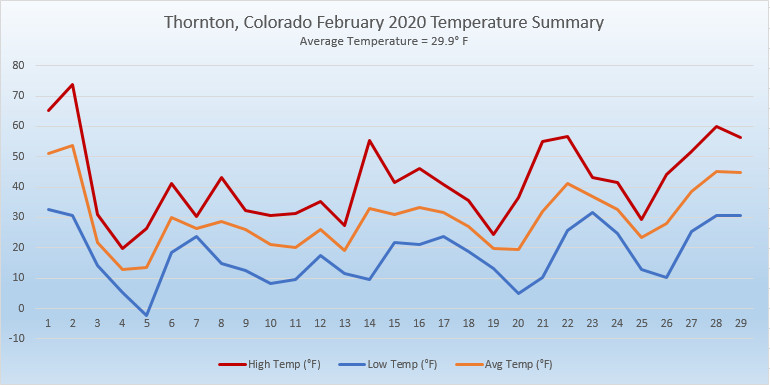
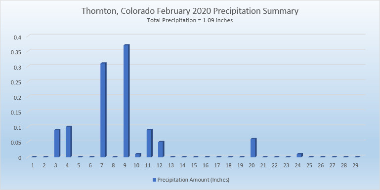
 February in Colorado typically brings to an end an extended period when average temperatures are at their lowest. Winter begins to loosen its grip and temperatures get warmer but precipitation is not a particularly common event during the month.