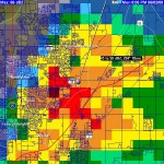
 Monday evening was a bit interesting around Thornton as hail was reported across much of the city. Toward the northeast corner, hailstones up to 1″ in diameter were reported, including at the home of ThorntonWeather.com. Thankfully it was shortlived and the size of the hail while notable, wasn’t big enough and didn’t last long enough to do any real damage. The image at the right is the radar image of the storm as it passed over – click on it to view the full image. That particular cell broke its upper cap of 26,000 feet and grew to 32,000 feet in a span of 15 minutes!
Tuesday could bring severe storms again thanks to an abudnance of lower level moisture. However, cooler temperatures should help to keep these from becoming quite as severe but hail and wind are a possibility. As is typical this time of year, east of the urban corridor has the best chance to see some excitement.
Wednesday afternoon and evening the chance for storms increases as a cold front moves through but again, the cooler temps should help to keep things a bit under control. Locally heavy rain is possible, particularly the farther east you go. In the mountains, there may even be some of the white stuff above 9,500 feet!
