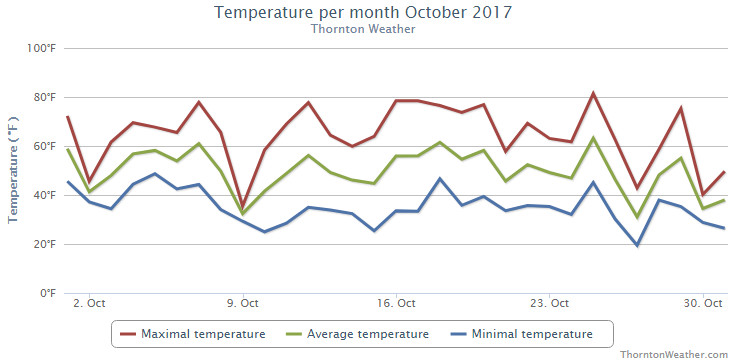
The month of October certainly saw its fair share of varying temperatures. We seemed to go back and forth between unseasonably warm to unseasonably cold readings. The month also brought us our first measurable snow of the season and a good bit of precipitation.
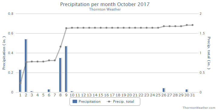
The month started with comfortable readings and dry conditions. On the 9th of the month though things turned considerably colder and Thornton recorded 4.1 inches of snow.
We immediately rebounded though and warmer weather returned. A string of 70 plus degree days from the 16th to the 20th were quite nice. We also stayed dry until the last week of the month.
On the 25th we saw a record-setting high temperature but then 72 hours saw our coldest reading of the month (19.4 degrees). There again, we bounced back with a warm day on the 29th before finishing up with much colder weather the last two days of the month. We did see some minimal rain on the 26th and 30th to add to the precipitation total for the month.
Thornton saw an overall average monthly temperature of 48.6 degrees. This was a good ways below Denver’s long term October average of 50.9 degrees. Out at DIA where the Mile High City’s official measurements are taken, they were warmer with an average of 50.1 degrees.
Our mercury readings ranged from a high of 84.9 degrees on the 25th down to the 19.4 degree reading on the 27th. DIA saw similar extremes with a maximum of 84 degrees and a minimum of 13 degrees on those same dates. The reading of 84 degrees on the 25th was a record high for the date.
In terms of precipitation, Thornton recorded 1.71 inches. Denver lagged considerably with 0.96 inches for the month. Those put Thornton well above, Denver just below the October average of 1.02 inches.
Denver averages 4.0 inches of snowfall in October. Thornton bested that by just a bit with 4.6 inches, the majority of which came on the 9th. Out at the airport, they could only tally 2.8 inches of the white stuff.
Click here to view Thornton’s October 2017 climate report.
From the National Weather Service:
CLIMATE REPORT
NATIONAL WEATHER SERVICE DENVER/BOULDER CO
303 AM MDT WED NOV 1  2017

...................................

...THE DENVER CO CLIMATE SUMMARY FOR THE MONTH OF OCTOBER 2017...

CLIMATE NORMAL PERIOD 1981 TO 2010
CLIMATE RECORD PERIOD 1872 TO 2017

WEATHER         OBSERVED          NORMAL  DEPART  LAST YEAR`S
                 VALUE   DATE(S)  VALUE   FROM    VALUE  DATE(S)
                                          NORMAL
................................................................
TEMPERATURE (F)
RECORD
 HIGH              89   10/16/1991
                        10/10/1910
 LOW               -2   10/29/1917
HIGHEST            84   10/25        83       1       86  10/16
LOWEST             13   10/27        22      -9       25  10/20
AVG. MAXIMUM     64.5              65.3    -0.8     74.5
AVG. MINIMUM     35.7              36.6    -0.9     41.2
MEAN             50.1              50.9    -0.8     57.8
DAYS MAX >= 90      0               0.0     0.0        0
DAYS MAX <= 32      0               0.4    -0.4        0
DAYS MIN <= 32     11               8.5     2.5        3
DAYS MIN <= 0       0               0.0     0.0        0

PRECIPITATION (INCHES)
RECORD
 MAXIMUM         4.17   1969
 MINIMUM            T   1934
TOTALS           0.96              1.02   -0.06     0.26
DAILY AVG.       0.03              0.03    0.00     0.01
DAYS >= .01         5               5.3    -0.3        3
DAYS >= .10         4               2.4     1.6        1
DAYS >= .50         0               0.5    -0.5        0
DAYS >= 1.00        0               0.1    -0.1        0
GREATEST
 24 HR. TOTAL    0.35   10/09 TO 10/09           10/05 TO 10/06

SNOWFALL (INCHES)
RECORDS
 TOTAL             2.8
TOTALS            2.8               4.0

DEGREE_DAYS
HEATING TOTAL     455               440      15      231
 SINCE 7/1        585               581       4      310
COOLING TOTAL       1                 5      -4       17
 SINCE 1/1        881               769     112      878

FREEZE DATES
RECORD
 EARLIEST     09/08/1962
 LATEST       06/08/2007
EARLIEST      10/09             10/07
LATEST                          05/05
.................................................................

WIND (MPH)
AVERAGE WIND SPEED              10.3
RESULTANT WIND SPEED/DIRECTION   2/232
HIGHEST WIND SPEED/DIRECTION    46/300    DATE  10/14
HIGHEST GUST SPEED/DIRECTION    59/300    DATE  10/14

SKY COVER
POSSIBLE SUNSHINE (PERCENT)   MM
AVERAGE SKY COVER           0.50
NUMBER OF DAYS FAIR           11
NUMBER OF DAYS PC             15
NUMBER OF DAYS CLOUDY          5

AVERAGE RH (PERCENT)     48

WEATHER CONDITIONS. NUMBER OF DAYS WITH
THUNDERSTORM              3     MIXED PRECIP               0
HEAVY RAIN                0     RAIN                       1
LIGHT RAIN                8     FREEZING RAIN              1
LT FREEZING RAIN          1     HAIL                       0
HEAVY SNOW                0     SNOW                       4
LIGHT SNOW                4     SLEET                      0
FOG                      10     FOG W/VIS <= 1/4 MILE      5
HAZE                      6

-  INDICATES NEGATIVE NUMBERS.
R  INDICATES RECORD WAS SET OR TIED.
MM INDICATES DATA IS MISSING.
T  INDICATES TRACE AMOUNT.