For the second month in a row, Mother Nature kept us cold and delivered a healthy dose of snow. Thornton experienced its second coldest November of the past 13 years and the snowiest of the past 13 years.
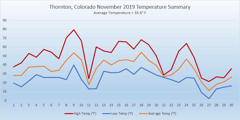
The month started out chilly but soon saw things stabilize and turn seasonal. Then, the 8th and 9th offered up our two warmest days of the month with readings of 71 and 79 degrees respectively. We quickly chilled out and saw our first snowfall of the month on the 9th although it was minimal.
From the 12th to the 19th, weather was relatively calm and temperatures for the most part warmer than normal.
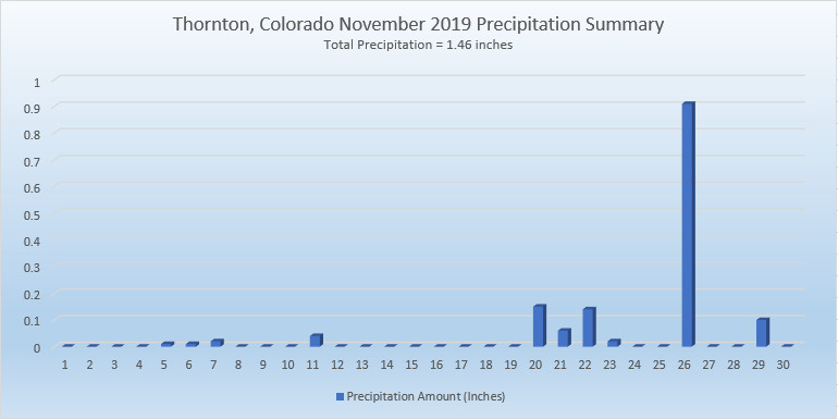
After that, things went downhill with most of the balance of the month seeing temperatures well below normal. Light snow on the 20th, 21st and 22nd was followed by our most significant storm of the season on the 26th.
Thornton saw an overall overage temperature for November of 35.6 degrees. This was a good ways below the long term Denver average for the month of 38.3 degrees. Out at Denver International Airport where Denver’s official measurements are taken, the average temperature for the month was 36.2 degrees.
Temperatures in Thornton ranged from a high of 79 degrees on the 9th down to a low of 2 degrees on the 27th. Out at the airport, Denver saw its warmest reading of 77 degrees on the 9th also and its coldest temperature of -2 degrees on the 27th. The high temperature on the 9th was a record high for the date.
A generous amount of precipitation was received with Thornton recording 1.46 inches of rain and snowmelt. Denver lagged a bit with 1.31 inches. Both readings were well above the long term Denver average of 0.61 inches for November.
In terms of snowfall, the Mile High City averages 8.7 inches in November. Thornton’s reading of 16.7 inches and Denver’s of 13.7 inches easily bested the average.
Click here to view Thornton’s November 2019 climate report.
CLIMATE REPORT
NATIONAL WEATHER SERVICE DENVER/BOULDER CO
905 AM MST SUN DEC 1 2019

...................................

...THE DENVER CO CLIMATE SUMMARY FOR THE MONTH OF NOVEMBER 2019...

CLIMATE NORMAL PERIOD 1981 TO 2010
CLIMATE RECORD PERIOD 1872 TO 2019

WEATHER         OBSERVED          NORMAL  DEPART  LAST YEAR`S
                 VALUE   DATE(S)  VALUE   FROM    VALUE  DATE(S)
                                          NORMAL
................................................................
TEMPERATURE (F)
RECORD
 HIGH              81   11/27/2017
 LOW              -18   11/29/1877
HIGHEST            77   11/09        73       4       65  11/02
LOWEST             -2   11/27        -6       4       10  11/12
AVG. MAXIMUM     49.7              52.1    -2.4     50.6
AVG. MINIMUM     22.7              24.5    -1.8     25.0
MEAN             36.2              38.3    -2.1     37.8
DAYS MAX >= 90      0               0.0     0.0        0
DAYS MAX <= 32      7               2.3     4.7        2
DAYS MIN <= 32     25              23.4     1.6       27
DAYS MIN <= 0       1               0.6     0.4        0

PRECIPITATION (INCHES)
RECORD
 MAXIMUM         3.21   1946
 MINIMUM            T   1899
                        1901
                        1949
TOTALS           1.31              0.61    0.70     0.35
DAILY AVG.       0.04              0.02    0.02     0.01
DAYS >= .01         8               4.7     3.3        6
DAYS >= .10         4               1.6     2.4        1
DAYS >= .50         1               0.0     1.0        0
DAYS >= 1.00        0               0.0     0.0        0
GREATEST
 24 HR. TOTAL    0.80   11/26 TO 11/26           11/11 TO 11/11

SNOWFALL (INCHES)
RECORDS
 TOTAL           13.7               8.7
RECORD NOVEMBER  42.5   1946

DEGREE_DAYS
HEATING TOTAL     860               801      59      808
 SINCE 7/1       1535              1382     153     1373
COOLING TOTAL       0                 0       0        0
 SINCE 1/1        916               769     147     1026

FREEZE DATES
RECORD
 EARLIEST     09/08/1962
 LATEST       06/08/2007
EARLIEST                        10/07
LATEST                          05/05
.................................................................

WIND (MPH)
AVERAGE WIND SPEED              9.3
RESULTANT WIND SPEED/DIRECTION   2/197
HIGHEST WIND SPEED/DIRECTION    37/020    DATE  11/16
HIGHEST GUST SPEED/DIRECTION    48/010    DATE  11/16

SKY COVER
POSSIBLE SUNSHINE (PERCENT)   MM
AVERAGE SKY COVER           0.50
NUMBER OF DAYS FAIR            7
NUMBER OF DAYS PC             18
NUMBER OF DAYS CLOUDY          5

AVERAGE RH (PERCENT)     65

-  INDICATES NEGATIVE NUMBERS.
R  INDICATES RECORD WAS SET OR TIED.
MM INDICATES DATA IS MISSING.
T  INDICATES TRACE AMOUNT.