Mild, dry conditions started the month of November 2015 in Thornton. That however soon gave way to colder temperatures and moisture in the form of snow, something that repeated itself multiple times during the month.
The first three days saw temperatures well above normal and in the 70s with no precipitation. That changed however with our first snowfall of the season coming on the 5th of the month.
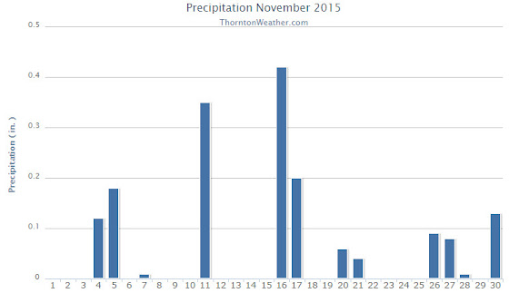
The balance of the month was an active one as a series of troughs moved through and cold fronts dug in from the north. A general pattern of a few mild days followed by a few unsettled days was the pattern. By the time all was said and done, the month more than made up for the lack of snow in October.
In terms of temperatures, Thornton’s overall temperature for the month was 36.9 degrees. Out at DIA where Denver’s official records are kept, the reading was a good bit warmer at 38.5 degrees. While that meant the Mile High City was 0.2 degrees above average, Thornton was clearly a good bit cooler than normal.
Temperatures in Thornton ranged from a high of 75.5 degrees on the third of the month down to a low of 6.7 degrees on the morning of the 27th. DIA saw a maximum of 75 degrees and a minimum of 3 degrees on those same dates.
Precipitation was well above the November average of 0.61 inches at both locations. Thornton saw 1.65 inches of liquid precip while Denver bested us with 2.13 inches.
Snow was the primary source of precipitation for the month. Thornton recorded a very healthy 14.5 inches of the white stuff. The airport lagged with 11.3 inches. Both were well above the November average of 8.7 inches.
Click here to view Thornton’s November 2015 climate report.

From the National Weather Service:
CLIMATE REPORT
NATIONAL WEATHER SERVICE BOULDER, CO
1147 AM MST TUE DEC 1 2015

...................................

...THE DENVER CO CLIMATE SUMMARY FOR THE MONTH OF NOVEMBER 2015...

CLIMATE NORMAL PERIOD 1981 TO 2010
CLIMATE RECORD PERIOD 1872 TO 2015

WEATHER         OBSERVED          NORMAL  DEPART  LAST YEAR`S
                 VALUE   DATE(S)  VALUE   FROM    VALUE  DATE(S)
                                          NORMAL
................................................................
TEMPERATURE (F)
RECORD
 HIGH              80   11/08/2006
 LOW              -18   11/29/1877
HIGHEST            75   11/03        73       2       72  11/29
                                                          11/01
LOWEST              3   11/27        -6       9      -14  11/13
AVG. MAXIMUM     51.2              52.1    -0.9     50.6
AVG. MINIMUM     25.7              24.5     1.2     21.8
MEAN             38.5              38.3     0.2     36.2
DAYS MAX >= 90      0               0.0     0.0        0
DAYS MAX <= 32      5               2.3     2.7        5
DAYS MIN <= 32     24              23.4     0.6       22
DAYS MIN <= 0 0 0.6 -0.6 4 PRECIPITATION (INCHES) RECORD MAXIMUM 3.21 1946 MINIMUM T 1899 1901 1949 TOTALS 2.13 0.61 1.52 0.76 DAILY AVG. 0.07 0.02 0.05 0.03 DAYS >= .01        11               4.7     6.3        6
DAYS >= .10         6               1.6     4.4        3
DAYS >= .50         1               0.0     1.0        0
DAYS >= 1.00        0               0.0     0.0        0
GREATEST
 24 HR. TOTAL    0.88   11/04 TO 11/05

SNOWFALL (INCHES)
RECORDS
 TOTAL           11.3               8.7
RECORD NOVEMBER  42.6                             1946

DEGREE_DAYS
HEATING TOTAL     789               801     -12      857
 SINCE 7/1       1090              1382    -292     1254
COOLING TOTAL       0                 0       0        0
 SINCE 1/1        877               769     108      701

FREEZE DATES
RECORD
 EARLIEST     09/08/1962
 LATEST       06/08/2007
EARLIEST      11/05             10/07
LATEST                          05/05
....................................................

WIND (MPH)
AVERAGE WIND SPEED              10.4
RESULTANT WIND SPEED/DIRECTION   3/225
HIGHEST WIND SPEED/DIRECTION    46/350    DATE  11/17
HIGHEST GUST SPEED/DIRECTION    57/290    DATE  11/18

SKY COVER
POSSIBLE SUNSHINE (PERCENT)   MM
AVERAGE SKY COVER           0.40
NUMBER OF DAYS FAIR           11
NUMBER OF DAYS PC             14
NUMBER OF DAYS CLOUDY          5

AVERAGE RH (PERCENT)     55

WEATHER CONDITIONS. NUMBER OF DAYS WITH
THUNDERSTORM              1     MIXED PRECIP               0
HEAVY RAIN                2     RAIN                       3
LIGHT RAIN                3     FREEZING RAIN              0
LT FREEZING RAIN          2     HAIL                       0
HEAVY SNOW                1     SNOW                       8
LIGHT SNOW               11     SLEET                      0
FOG                      13     FOG W/VIS <= 1/4 MILE      3
HAZE                      5

-  INDICATES NEGATIVE NUMBERS.
R  INDICATES RECORD WAS SET OR TIED.
MM INDICATES DATA IS MISSING.
T  INDICATES TRACE AMOUNT.