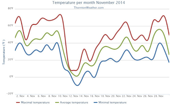
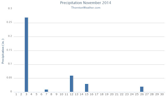
The month of November this year was one that saw some widely varying temperatures from comfortable fall readings to bone chilling cold. Precipitation ran light and while we saw our first measurable snows for the season, it was still dry.
With a high pressure ridge above, the month started out quite nice. A cold front moved through on the third and not only cooled things down, but also brought the bulk of our precipitation for the month in the form of rain.
We then saw a week of unseasonably warm conditions that lasted through the 10th. After that, the bottom fell out and the mercury plunged. Five of the next six days failed to climb above freezing as bone-chilling cold more akin to January was seen. We did manage to record more than two inches of snow over the same period.
A largely seasonal weather pattern then settled in with most of the next nine days having readings not too far from average. Three of the last four days of the month then brought back very mild conditions.
Thornton’s overall average temperature for the month was 35.1 degrees. This was well below the long term November average for Denver of 38.3 degrees. Out at the airport, official Denver readings were a bit warmer with an average of 36.2 degrees.
Thornton’s warmest reading in November came on the 29th with maximum of 72.5 degrees. The coldest was -8.8 degrees on the morning of the 13th. Denver’s maximum was similar to ours at 72 degrees but its coldest was a bit further down there at -14 degrees.
Five temperature records were set for the month, only one was for a warm reading. That came on the 9th with a record high minimum.
On the other hand, demonstrating just how significant the cold blast in the middle of the month was, Denver set four cold temperature related records for the month. These included record low maximums on the 11th and 12th and record lows on the 12th and 13th.
In terms of precipitation, Thornton finished below average while Denver was slightly above. The November average is 0.61 inches. Here in Thornton we had a mere 0.39 inches while DIA recorded 0.76.
November is one of our snowiest months but that was certainly not the case this year. While the long term average is 8.7 inches, Thornton recorded only 3.0 inches and Denver 4.0 inches.
Click here to view Thornton’s November 2014 climate report.
From the National Weather Service:
CLIMATE REPORT
NATIONAL WEATHER SERVICE BOULDER, CO
144 AM MST MON DEC 1 2014

...................................

...THE DENVER CO CLIMATE SUMMARY FOR THE MONTH OF NOVEMBER 2014...

CLIMATE NORMAL PERIOD 1981 TO 2010
CLIMATE RECORD PERIOD 1872 TO 2014

WEATHER         OBSERVED          NORMAL  DEPART  LAST YEAR`S
                 VALUE   DATE(S)  VALUE   FROM    VALUE  DATE(S)
                                          NORMAL
................................................................
TEMPERATURE (F)
RECORD
 HIGH              80   11/08/2006
 LOW              -18   11/29/1877
HIGHEST            72   11/29        73       7       71  11/13
                        11/01
LOWEST            -14   11/13         6      -8       12  11/21
AVG. MAXIMUM     50.6              52.1    -1.5     55.1
AVG. MINIMUM     21.8              24.5    -2.7     26.7
MEAN             36.2              38.3    -2.1     40.9
DAYS MAX >= 90      0               0.0     0.0        0
DAYS MAX <= 32      5               2.3     2.7        2
DAYS MIN <= 32     22              23.4    -1.4       25
DAYS MIN <= 0       4               0.6     3.4        0
PRECIPITATION (INCHES)
RECORD
 MAXIMUM         3.21   1946
 MINIMUM            T   1899
                        1901
                        1949
TOTALS           0.76              0.61    0.15     0.27
DAILY AVG.       0.03              0.02    0.01     0.01
DAYS >= .01         6               4.7     1.3        3
DAYS >= .10         3               1.6     1.4        1
DAYS >= .50         0               0.0     0.0        0
DAYS >= 1.00        0               0.0     0.0        0
GREATEST
 24 HR. TOTAL    0.30   11/03 TO 11/03           11/21 TO 11/21

SNOWFALL (INCHES)
RECORDS
 TOTAL           42.6   1946
TOTALS            4.0               8.7

DEGREE_DAYS
HEATING TOTAL     857               801      56      715
 SINCE 7/1       1254              1382    -128     1323
COOLING TOTAL       0                 0       0        0
 SINCE 1/1        701               769     -68      999

FREEZE DATES
RECORD
 EARLIEST     09/08/1962
 LATEST       06/08/2007
EARLIEST                        10/07
LATEST                          05/05
..................................................

WIND (MPH)
AVERAGE WIND SPEED              10.1
RESULTANT WIND SPEED/DIRECTION   3/228
HIGHEST WIND SPEED/DIRECTION    43/040    DATE  11/10
HIGHEST GUST SPEED/DIRECTION    54/040    DATE  11/10

SKY COVER
POSSIBLE SUNSHINE (PERCENT)   MM
AVERAGE SKY COVER           0.60
NUMBER OF DAYS FAIR            4
NUMBER OF DAYS PC             21
NUMBER OF DAYS CLOUDY          5

AVERAGE RH (PERCENT)     53

WEATHER CONDITIONS. NUMBER OF DAYS WITH
THUNDERSTORM              1     MIXED PRECIP               1
HEAVY RAIN                1     RAIN                       2
LIGHT RAIN                2     FREEZING RAIN              0
LT FREEZING RAIN          0     HAIL                       0
HEAVY SNOW                1     SNOW                       3
LIGHT SNOW                7     SLEET                      0
FOG                       8     FOG W/VIS <= 1/4 MILE      1
HAZE                      5

-  INDICATES NEGATIVE NUMBERS.
R  INDICATES RECORD WAS SET OR TIED.
MM INDICATES DATA IS MISSING.
T  INDICATES TRACE AMOUNT.