There is little doubt that looking back on the month the most notable feature was the cool, sometimes chilly, temperatures. Denver in fact saw one of its coldest on record. Precipitation for Thornton lagged but Denver itself was quite wet.
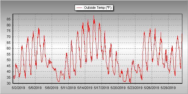
A seemingly endless series of storm systems impacted the state through the month. Overall, the first week was seasonal and dry. Temperatures then cooled for a couple of days and delivered us a light shot of snow. We rebounded with a series of 80 degree days from the 13th to the 16 before once again chilling out.
From the 18th to the 23rd, temperatures remained below normal and on the 21st we received a respectable 3.3 inches of snow. Temperatures during that period dropped to below freezing three times.
The balance of the month continued the roller coaster with a few mild days followed by cooler ones.
Thornton’s overall average monthly temperature for May came in at 51.9 degrees. This made it the coldest May since ThorntonWeather.com came online 13 years ago.
Out at DIA where Denver’s official measurements are taken, the month was comparable with a 51.6 degree average. That made May 2019 the seventh coldest May on record and the coldest since 1995.
Highs ranged in Thornton from a maximum of 89 degrees on the 15th down to a lowest reading of 29.8 degrees on the 22nd. Denver’s highest reading of 83 degrees and its coldest of 30 degrees came on the same dates.
Three temperature records were officially set in Denver. The record low for May 21st of 31 degrees was tied. Also on that day, a record low maximum of 39 degrees was set. The old record was 40 degrees set in 1891. Lastly, the low on the 22nd of 30 degrees broke the record low reading for the date of 32 degrees set in 1930.
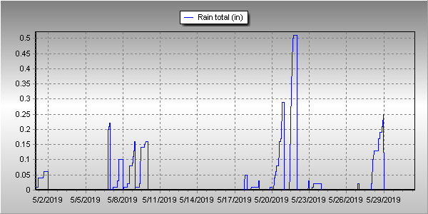
In terms of precipitation, Denver averages 2.12 inches during the month. Thornton came close to matching that with 2.03 inches. Out at the airport, it was wetter with 3.23 inches being recorded.
Thornton saw a total of 4.1 inches of snow for the month while Denver saw a bit less at 3.9 inches. Both were well above the May average of 1.1 inches.
Click here to view Thornton’s May 2019 climate report.
CLIMATE REPORT
NATIONAL WEATHER SERVICE DENVER/BOULDER CO
753 AM MDT SAT JUN 1 2019

...................................

...THE DENVER CO CLIMATE SUMMARY FOR THE MONTH OF MAY 2019...

CLIMATE NORMAL PERIOD 1981 TO 2010
CLIMATE RECORD PERIOD 1872 TO 2019

WEATHER         OBSERVED          NORMAL  DEPART  LAST YEAR`S
                 VALUE   DATE(S)  VALUE   FROM    VALUE  DATE(S)
                                          NORMAL
................................................................
TEMPERATURE (F)
RECORD
 HIGH              95   05/26/1942
 LOW               19   05/02/2013
                        05/03/1907
HIGHEST            83   05/15
LOWEST             30   05/22
                        05/01

AVG. MAXIMUM     63.9              71.5    -7.6     75.4
AVG. MINIMUM     39.2              42.7    -3.5     47.5
MEAN             51.6              57.1    -5.5     61.4
DAYS MAX >= 90      0               0.8    -0.8        4
DAYS MAX <= 32      0               0.0     0.0        0
DAYS MIN <= 32      7               1.9     5.1        0
DAYS MIN <= 0 0 0.0 0.0 0 PRECIPITATION (INCHES) RECORD MAXIMUM 8.57 1876 MINIMUM 0.06 1974 TOTALS 3.23 2.12 1.11 1.86 DAILY AVG. 0.10 0.07 0.03 0.06 DAYS >= .01        14               9.4     4.6        8
DAYS >= .10         7               4.8     2.2        5
DAYS >= .50         3               1.2     1.8        0
DAYS >= 1.00        1               0.2     0.8        0
GREATEST
 24 HR. TOTAL    1.07   05/20 TO 05/20

SNOWFALL (INCHES)
TOTALS            3.9   2019        1.1 (NCEI 1981-2018 AVG)
RECORD           15.5   1898

DEGREE_DAYS
HEATING TOTAL     414               265     149      151
 SINCE 7/1       6219              5996     223     5401
COOLING TOTAL       5                21     -16       46
 SINCE 1/1          5                22     -17       48

FREEZE DATES
RECORD
 EARLIEST     09/08/1962
 LATEST       06/08/2007
EARLIEST                        10/07
LATEST                          05/05
.................................................................

WIND (MPH)
AVERAGE WIND SPEED              10.0
RESULTANT WIND SPEED/DIRECTION   1/090
HIGHEST WIND SPEED/DIRECTION    35/310    DATE  05/17
HIGHEST GUST SPEED/DIRECTION    50/310    DATE  05/17

SKY COVER
POSSIBLE SUNSHINE (PERCENT)   MM
AVERAGE SKY COVER           0.60
NUMBER OF DAYS FAIR            3
NUMBER OF DAYS PC             16
NUMBER OF DAYS CLOUDY         12

AVERAGE RH (PERCENT)     64

-  INDICATES NEGATIVE NUMBERS.
R  INDICATES RECORD WAS SET OR TIED.
MM INDICATES DATA IS MISSING.
T  INDICATES TRACE AMOUNT.