The major winter storm we have been tracking for the last couple of days continues on its path toward Denver and the Front Range and before it is over, Denver could see more than a foot of snow. The latest computer models indicate the storm is coming a bit further north than previously thought which increases the changes for what will be a very significant snow event for us.
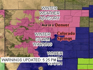
Snow in the mountains tonight will begin to spread to Denver and the Front Range Thursday morning and it will last through Thursday evening and beyond. Highlighting the significance of the storm, the National Weather Service has issued a Winter Storm Warning (see below for text of warning) for all of northeastern Colorado including Denver.
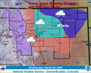
The NWS is forecasting snow totals from 8 to 15 inches for the metro area (see image below) and from 1 to 2 feet along the Palmer Divide. I think that may be a bit optimistic myself but there is little doubt we are in for our biggest storm of the snow season. Areas south and west like Highlands Ranch, Parker and Golden will almost certainly experience the most snow in the metro area. See the image below for potential snow totals.
The brunt of the storm will be after noon through late evening, thus making for what will probably be a very treacherous rush hour drive so plan accordingly and drive safe. Stay tuned to Examiner.com for the latest as this system arrives in Denver.

Here are the details on the Winter Storm Watch from the National Weather Service:
URGENT – WINTER WEATHER MESSAGE
NATIONAL WEATHER SERVICE DENVER CO
753 PM MDT WED MAR 25 2009
..POWERFUL WINTER STORM ON THE WAY FOR NORTH CENTRAL AND NORTHEAST COLORADO…
A POTENT STORM SYSTEM ORGANIZING OVER THE GREAT BASIN TONIGHT WILL TRACK ACROSS THE FOUR CORNERS REGION THURSDAY AND INTO NORTHEAST NEW MEXICO THURSDAY NIGHT. HEAVY SNOW WAS ALREADY DEVELOPING THIS EVENING IN THE MOUNTAINS…AND STRONG CIRCULATION AROUND THIS STORM SYSTEM WILL BRING HEAVY SNOWFALL DOWN INTO THE FRONT RANGE FOOTHILLS AND ACROSS MOST OF THE PLAINS OF NORTHEAST COLORADO THURSDAY INTO THURSDAY NIGHT. IN ADDITION…THE PLAINS WILL SEE STRONG AND GUSTY NORTHEAST WINDS DEVELOPING THURSDAY MORNING FOLLOWING THE PASSAGE OF STRONG COLD FRONT. THE HIGH MOUNTAIN PASSES AND PALMER DIVIDE AREA MAY SEE NEAR BLIZZARD CONDITIONS DURING THE AFTERNOON AND EVENING HOURS.
PEOPLE PLANNING TRAVEL IN THE MOUNTAINS…AND ACROSS THE PLAINS OF NORTH CENTRAL AND NORTHEAST COLORADO SHOULD STAY TUNED TO THE NATIONAL WEATHER SERVICE OR YOUR LOCAL NEWS MEDIA FOR THE LATEST INFORMATION AND WEATHER UPDATES ON THIS POTENT WINTER-LIKE STORM SYSTEM.
..WINTER STORM WARNING REMAINS IN EFFECT FROM 6 AM THURSDAY TO
6 AM MDT FRIDAY…
SNOW WILL DEVELOP IN THE FRONT RANGE FOOTHILLS TONIGHT…AND ACROSS THE PLAINS LATE TONIGHT INTO EARLY THURSDAY MORNING. SNOWFALL IS THEN EXPECTED TO BECOME WIDESPREAD AND HEAVY AT TIMES FOLLOWING THE PASSAGE OF A STRONG COLD FRONT EARLY THURSDAY MORNING. AT THIS TIME…THE HEAVIEST SNOW IS EXPECTED TO OCCUR FROM MID MORNING THROUGH THE MID EVENING HOURS THURSDAY. IN ADDITION…NORTH TO NORTHEAST WINDS OF 20 TO 30 MPH AND GUSTS TO AROUND 45 MPH MAY ALSO PRODUCE CONSIDERABLE BLOWING AND DRIFTING SNOW…WITH NEAR WHITEOUT CONDITIONS POSSIBLE ON THE PALMER DIVIDE SOUTH OF DENVER.
TOTAL SNOW ACCUMULATIONS BY LATE THURSDAY NIGHT WILL RANGE FROM 8 TO 16 INCHES IN THE I-25 URBAN CORRIDOR AND ACROSS SOUTH PARK…AND FROM 1 TO 2 FEET IN THE FRONT RANGE FOOTHILLS AND OVER THE PALMER DIVIDE. OVER THE FAR NORTHEASTER PLAINS…SNOWFALL AMOUNTS ARE EXPECTED TO BE CLOSER TO 6 INCHES.
REMEMBER…A WINTER STORM WARNING MEANS HAZARDOUS WINTER WEATHER CONDITIONS ARE IMMINENT OR HIGHLY LIKELY. SIGNIFICANT SNOW ACCUMULATIONS ARE OCCURRING OR EXPECTED. STRONG WINDS ARE ALSO EXPECTED. THIS WILL MAKE TRAVEL VERY HAZARDOUS OR IMPOSSIBLE.
