All-in-all, while temperatures and precipitation rain a bit lower than average, June 2014’s weather was pretty close to what we typically expect to see. Thunderstorms made their appearances as always but we were spared much in the way of severe weather.
A series of fronts and troughs moved through northern Colorado during the month. This helped to keep temperatures down and provided thunderstorms with a bit of regularity.
Thornton’s average temperature for the month came in at 66.5 degrees. This is less than one degree below Denver’s historical June average of 67.4 degrees. The Mile High City’s average came in slightly warmer at 67.3 degrees.
Temperatures in Thornton ranged from a high of 92.1 degrees on June 3rd down to a low of 38.2 degrees on the morning of the 9th. Denver was warmer on both measurements with a maximum reading of 94 degrees on the 26th and a low of 42 degrees on the 15th.
Six days saw temperatures top the 90 degree mark in Thornton and Denver. This is below the historical average of 7.9 days of 90 degree or warmer readings we expect to see.
No temperature records were set during the month.
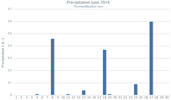
In terms of precipitation, Thornton had 1.59 inches fall into our rain bucket. Denver was a bit wetter with 1.82 inches. Both fell below the June average of 1.98 inches. Thornton saw eight days with measurable precipitation, Denver nine.
Denver set a daily precipitation record of 0.51 inches on the 27th. This bested the old record for that date of 0.29 inches in 1949. Thornton recorded 0.60 inches on the same day.
Click here to view Thornton’s June 2014 climate report.

...THE DENVER CO CLIMATE SUMMARY FOR THE MONTH OF JUNE 2014...

CLIMATE NORMAL PERIOD 1981 TO 2010
CLIMATE RECORD PERIOD 1872 TO 2014

WEATHER         OBSERVED          NORMAL  DEPART  LAST YEAR`S
                 VALUE   DATE(S)  VALUE   FROM    VALUE  DATE(S)
                                          NORMAL
................................................................
TEMPERATURE (F)
RECORD
 HIGH             105   06/26/2012
                        06/25/2012
                        54/01/2206
 LOW               30   06/02/1951
HIGHEST            94   06/26
LOWEST             42   06/15
AVG. MAXIMUM     83.4              82.4     1.0     87.8
AVG. MINIMUM     51.2              52.3    -1.1     54.3
MEAN             67.3              67.4    -0.1     71.1
DAYS MAX >= 90      6               7.9    -1.9       14
DAYS MAX <= 32      0               0.0     0.0        0
DAYS MIN <= 32      0               0.0     0.0        0
DAYS MIN <= 0       0               0.0     0.0        0

PRECIPITATION (INCHES)
RECORD
 MAXIMUM         4.96   1882
 MINIMUM            T   1890
TOTALS           1.82              1.98   -0.16     0.75
DAILY AVG.       0.06              0.07   -0.01     0.03
DAYS >= .01         9               8.4     0.6        4
DAYS >= .10         5               4.6     0.4        2
DAYS >= .50         1               1.4    -0.4        1
DAYS >= 1.00        0               0.3    -0.3        0
GREATEST
 24 HR. TOTAL    0.51   06/27 TO 06/27           06/23 TO 06/23
                        06/26 TO 06/27                    06/22 TO 06/23
                        06/27 TO 06/27                    06/23 TO 06/23
 STORM TOTAL       MM                                 MM
 (MM/DD(HH))            MM                    06/23(00) TO 06/23(00)
                                                 06/23(00) TO 06/23(00)3
                                                 06/23(00) TO 06/23(00)3

SNOWFALL (INCHES)
RECORDS
 TOTAL             MM   MM
TOTALS            0.0               0.0

DEGREE_DAYS
HEATING TOTAL      30                62     -32       29
 SINCE 7/1       6004              6058     -54     6084
COOLING TOTAL     106               133     -27      221
 SINCE 1/1        127               155     -28      263

FREEZE DATES
RECORD
 EARLIEST     09/08/1962
 LATEST       06/08/2007
EARLIEST      10/04             10/07
LATEST        05/14             05/05
....................................................

WIND (MPH)
AVERAGE WIND SPEED              10.5
RESULTANT WIND SPEED/DIRECTION   3/148
HIGHEST WIND SPEED/DIRECTION    39/300    DATE  06/18
HIGHEST GUST SPEED/DIRECTION    55/220    DATE  06/18

SKY COVER
POSSIBLE SUNSHINE (PERCENT)   MM
AVERAGE SKY COVER           0.50
NUMBER OF DAYS FAIR            8
NUMBER OF DAYS PC             21
NUMBER OF DAYS CLOUDY          1

AVERAGE RH (PERCENT)     53

WEATHER CONDITIONS. NUMBER OF DAYS WITH
THUNDERSTORM              0     MIXED PRECIP               0
HEAVY RAIN                3     RAIN                       3
LIGHT RAIN               12     FREEZING RAIN              0
LT FREEZING RAIN          0     HAIL                       3
HEAVY SNOW                0     SNOW                       0
LIGHT SNOW                0     SLEET                      0
FOG                       7     FOG W/VIS <= 1/4 MILE      4
HAZE                      4

-  INDICATES NEGATIVE NUMBERS.
R  INDICATES RECORD WAS SET OR TIED.
MM INDICATES DATA IS MISSING.
T  INDICATES TRACE AMOUNT.