Finally! Our winter thus far had been quite dry so seeing some precipitation in January was a very welcome change. Temperatures were just a bit above normal.
Overall, the month was short on any sort of real weather drama with no major storms or particularly notable temperature extremes. However, a series of storm systems did give us a bit of a roller coaster of weather with five different snow events over the month.
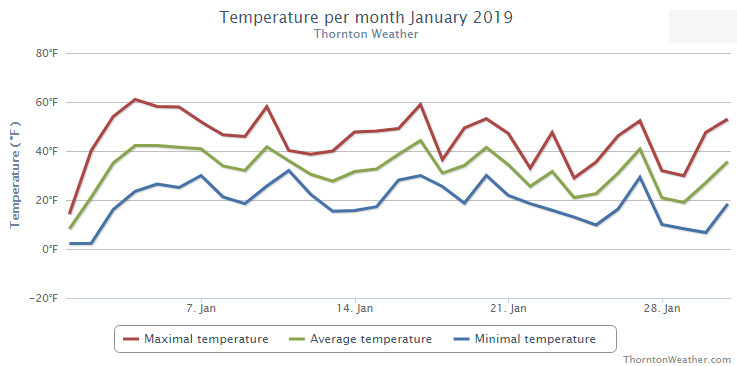
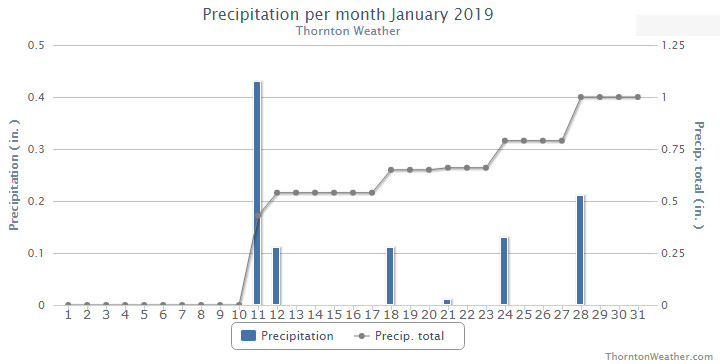
January started out with a very cold New Year’s Day but soon saw warmer temperatures arrive. Our first snow came on the 11th and 12th. This was followed by some smaller events and finally our biggest snowfall of the month on the 28th.
Thornton’s average temperature for the month came in at 31.3 degrees. This was a bit warmer than Denver’s long term overage for January of 30.7 degrees. Out at DIA where Denver’s official readings are taken, it was a bit warmer with an average of 32.0 degrees.
Our mercury readings ranged from a low of 2.2 degrees on the 1st and the 2nd to a high of 61.1 degrees a few days later on the 4th. Denver’s lowest reading was 5 degrees below zero on the first and its warmest of 62 degrees came on the 4th.
In terms of precipitation, Denver averages 0.41 inches of liquid precipitation during January. Thornton easily bested that with an even 1 inch in our bucket. Denver was above average as well with 0.75 inches.
Snowfall in Thornton saw above normal levels with a total for the month of 10.9 inches. Denver, as usual, lagged with 6.2 inches of the white stuff. The 30 year average for Denver for January is 7.0 inches.
Click here to view Thornton’s January 2019 climate report.
CLIMATE REPORT
NATIONAL WEATHER SERVICE DENVER/BOULDER CO
1026 AM MST FRI FEB 1 2019

...................................

...THE DENVER CO CLIMATE SUMMARY FOR THE MONTH OF JANUARY 2019...

CLIMATE NORMAL PERIOD 1981 TO 2010
CLIMATE RECORD PERIOD 1872 TO 2019

WEATHER         OBSERVED          NORMAL  DEPART  LAST YEAR`S
                 VALUE   DATE(S)  VALUE   FROM    VALUE  DATE(S)
                                          NORMAL
................................................................
TEMPERATURE (F)
RECORD
 HIGH              76   01/27/1888
 LOW              -29   01/09/1875
HIGHEST            62   01/04        76     -14       68  01/09
LOWEST             -5   01/01       -29      24       -4  01/16
AVG. MAXIMUM     44.6              44.0     0.6     49.2
AVG. MINIMUM     19.5              17.4     2.1     20.1
MEAN             32.0              30.7     1.3     34.7
DAYS MAX >= 90      0               0.0     0.0        0
DAYS MAX <= 32      6               5.5     0.5        3
DAYS MIN <= 32     29              29.4    -0.4       28
DAYS MIN <= 0       1               1.7    -0.7        2

PRECIPITATION (INCHES)
RECORD
 MAXIMUM         2.35   1883
 MINIMUM         0.01   1933
                        1934
                        1952
TOTALS           0.75              0.41    0.34     0.54
DAILY AVG.       0.02              0.01    0.01     0.02
DAYS >= .01         6               4.1     1.9        5
DAYS >= .10         2               0.9     1.1        2
DAYS >= .50         0               0.0     0.0        0
DAYS >= 1.00        0               0.0     0.0        0
GREATEST
 24 HR. TOTAL    0.45   01/11 TO 01/11           01/21 TO 01/21

OBSERVED          NORMAL  DEPART  LAST YEAR`S

SNOWFALL (INCHES)
TOTALS            6.2               7.0
RECORD           24.3  1992

DEGREE_DAYS
HEATING TOTAL    1016              1063     -47      932
 SINCE 7/1       3388              3531    -143     3082
COOLING TOTAL       0                 0       0        0
 SINCE 1/1          0                 0       0        0

FREEZE DATES
RECORD
 EARLIEST     09/08/1962
 LATEST       06/08/2007
EARLIEST                        10/07
LATEST                          05/05
.................................................................

WIND (MPH)
AVERAGE WIND SPEED              9.9
RESULTANT WIND SPEED/DIRECTION   4/214
HIGHEST WIND SPEED/DIRECTION    40/290    DATE  01/07
HIGHEST GUST SPEED/DIRECTION    54/350    DATE  01/22

SKY COVER
POSSIBLE SUNSHINE (PERCENT)   MM
AVERAGE SKY COVER           0.50
NUMBER OF DAYS FAIR           10
NUMBER OF DAYS PC             17
NUMBER OF DAYS CLOUDY          4

AVERAGE RH (PERCENT)     58


-  INDICATES NEGATIVE NUMBERS.
R  INDICATES RECORD WAS SET OR TIED.
MM INDICATES DATA IS MISSING.
T  INDICATES TRACE AMOUNT.