The month of January saw little in the way of weather drama. Temperatures definitely trended toward the warm side though and while the month’s snowfall came it close to normal, we head into March with a seasonal deficit.
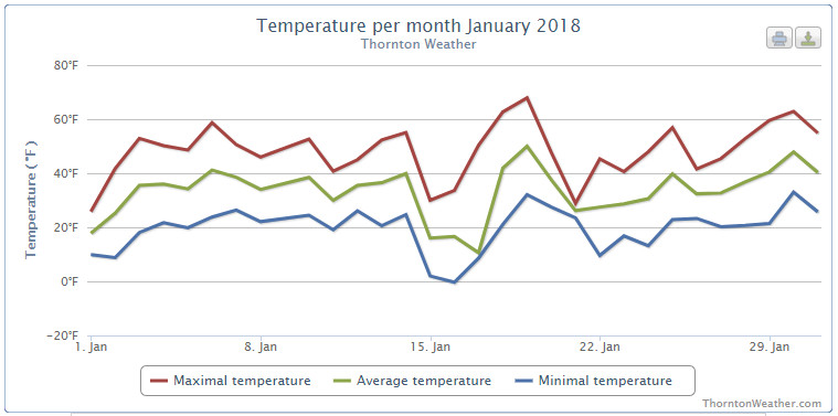
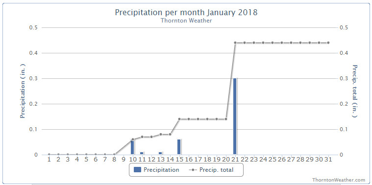
New Year’s Day started the month off cold but then we began a warming trend that saw average temperatures dominantly above normal for the first two weeks of the month. Precipitation was almost entirely absent during the period other than a bit of rain on the 10th.
On the 15th conditions like we expect in January returned – but only for two days. A quick, light shot of snow arrived and temperatures cooled to below normal.
We then returned to largely warmer than normal conditions until the 21st when we got not only our biggest snow of the month, but our biggest of the season so far. Sadly, that was only 4.9 inches of the white stuff.
From there, eight of the last ten days of the month saw above normal temperatures and no precipitation.
Thornton’s average temperature for January 2018 came in at 32.9 degrees. Denver’s long term average for the month is 30.7 degrees. Out at the airport where the Mile High City’s official measurements are taken, it was considerably warmer with an average of 34.7 degrees.
Our high temperatures ranged from a high of 69.3 degrees on the 9th down to a low of 0 degrees on the morning of the 16th. DIA recorded highs of 68 degrees and a low of -4 degrees on those same dates.
On average, Denver receives 0.41 inches of liquid precipitation in January. Thornton was just a hair above that with 0.44 inches and Denver bested that with 0.54 inches.
We recorded 6.1 inches of snow in Thornton during the month while the airport was just a bit higher with 6.4 inches. Both were short of Denver’s January average of 7.0 inches.
Click here to view Thornton’s January 2018 climate report.
CLIMATE REPORT
NATIONAL WEATHER SERVICE DENVER/BOULDER CO
650 AM MST THU FEB 1 2018

...................................

...THE DENVER CO CLIMATE SUMMARY FOR THE MONTH OF JANUARY 2018...

CLIMATE NORMAL PERIOD 1981 TO 2010
CLIMATE RECORD PERIOD 1872 TO 2018

WEATHER         OBSERVED          NORMAL  DEPART  LAST YEAR`S
                 VALUE   DATE(S)  VALUE   FROM    VALUE  DATE(S)
                                          NORMAL
................................................................
TEMPERATURE (F)
RECORD
 HIGH              76   01/27/1888
 LOW              -29   01/09/1875
HIGHEST            68   01/09        76      -8       63  01/30
LOWEST             -4   01/16       -29      25       -7  01/06
AVG. MAXIMUM     49.2              44.0     5.2     42.3
AVG. MINIMUM     20.1              17.4     2.7     17.7
MEAN             34.7              30.7     4.0     30.0
DAYS MAX >= 90      0               0.0     0.0        0
DAYS MAX <= 32      3               5.5    -2.5        8
DAYS MIN <= 32     28              29.4    -1.4       30
DAYS MIN <= 0       2               1.7     0.3        2

PRECIPITATION (INCHES)
RECORD
 MAXIMUM         2.35   1883
 MINIMUM         0.01   1933
                        1934
                        1952
TOTALS           0.54              0.41    0.13     0.54
DAILY AVG.       0.02              0.01    0.01     0.02
DAYS >= .01         5               4.1     0.9        3
DAYS >= .10         2               0.9     1.1        3
DAYS >= .50         0               0.0     0.0        0
DAYS >= 1.00        0               0.0     0.0        0
GREATEST
 24 HR. TOTAL    0.30   01/21 TO 01/21

SNOWFALL (INCHES)
TOTALS            6.4               7.0
RECORD
 MAX TOTAL       24.3   1992

DEGREE_DAYS
HEATING TOTAL     932              1063    -131     1075
 SINCE 7/1       3082              3531    -449     3117
COOLING TOTAL       0                 0       0        0
 SINCE 1/1          0                 0       0        0

FREEZE DATES
RECORD
 EARLIEST     09/08/1962
 LATEST       06/08/2007
EARLIEST                        10/07
LATEST                          05/05
.................................................................

WIND (MPH)
AVERAGE WIND SPEED              9.3
RESULTANT WIND SPEED/DIRECTION   4/193
HIGHEST WIND SPEED/DIRECTION    37/260    DATE  01/30
HIGHEST GUST SPEED/DIRECTION    48/270    DATE  01/30

SKY COVER
POSSIBLE SUNSHINE (PERCENT)   MM
AVERAGE SKY COVER           0.50
NUMBER OF DAYS FAIR            6
NUMBER OF DAYS PC             21
NUMBER OF DAYS CLOUDY          4

AVERAGE RH (PERCENT)     49

WEATHER CONDITIONS. NUMBER OF DAYS WITH
THUNDERSTORMS 0
HEAVY RAIN             2    MIXED PRECIP            3
LIGHT RAIN           0    RAIN                    1
LT FREEZING RAIN       0    FREEZING RAIN           0
HEAVY SNOW             3    HAIL                    0
LIGHT SNOW             0    SNOW                    7
FOG                    1    FOG W/VIS <=1/4 MILE    1
HAZE                   4

-  INDICATES NEGATIVE NUMBERS.
R  INDICATES RECORD WAS SET OR TIED.
MM INDICATES DATA IS MISSING.
T  INDICATES TRACE AMOUNT.