Look back at last month, we see that Thornton experienced an unusually warm month, one punctuated by a couple rare 70 degree January days. Precipitation fell short of normal as did snowfall.
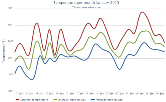
The month started out on the cold side with three of the first four days failing to reach temperatures above freezing. Some light snow was also recorded on the 2nd and 3rd of the month.
We then began a bit of a temperature rollercoaster with above normal readings for two days, a turn toward colder temperatures on the 9th, back to warmth on the next day and then colder than normal for the next four days.
Fourteen of the last 17 days of the month then recorded temperatures at or above normal. The 26th and 27th saw amazing readings above 70 degrees.
Overall, Thornton’s average temperature for the month came in at 33.7 degrees. That was well above Denver’s January average of 30.7 degrees. Out at Denver International Airport where the city’s official records are taken, the month saw a 33.9 degree average.
Thornton’s warmest reading of 74.5 degrees came on the 27th. Its coldest of -3.7 degrees occurred early in the morning of the 4th. Denver’s warmest and coldest readings came on the same days. DIA recorded 75 degrees on the 27th and -10 degrees on the 4th.
In terms of precipitation, 0.20 inches of liquid precipitation was recorded in Thornton. Denver nearly doubled our number with 0.38 inches. Both locations fell shy of Denver’s January average precipitation of 0.41 inches.
Snowfall in Thornton totaled only 3.5 inches, exactly have of Denver’s January average of 7.0 inches. Here again the airport bested us with 7.2 inches this January.
Click here to view Thornton’s January 2015 climate report.

From the National Weather Service:
CLIMATE REPORT
NATIONAL WEATHER SERVICE BOULDER, CO
614 AM MST SUN FEB 1 2015

...................................

...THE DENVER CO CLIMATE SUMMARY FOR THE MONTH OF JANUARY 2015...

CLIMATE NORMAL PERIOD 1981 TO 2010
CLIMATE RECORD PERIOD 1872 TO 2015

WEATHER         OBSERVED          NORMAL DEPART LAST YEAR`S
                 VALUE   DATE(S) VALUE   FROM    VALUE DATE(S)
                                         NORMAL
................................................................
TEMPERATURE (F)
RECORD
 HIGH              76   01/27/1888
 LOW              -29   01/09/1875
HIGHEST            75   01/27                         65 01/19
LOWEST            -10   01/04                        -10 01/05
AVG. MAXIMUM     46.7              44.0     2.7     44.9
AVG. MINIMUM     21.0              17.4     3.6     17.3
MEAN             33.9              30.7     3.2     31.1
DAYS MAX >= 90      0               0.0     0.0        0
DAYS MAX <= 32      5               5.5    -0.5        4
DAYS MIN <= 32     27              29.4    -2.4       30
DAYS MIN <= 0       3               1.7     1.3        3

PRECIPITATION (INCHES)
RECORD
 MAXIMUM         2.35   1883
 MINIMUM         0.01   1933
                        1934
                        1952
TOTALS           0.38              0.41   -0.03     0.94
DAILY AVG.       0.01              0.01    0.00     0.03
DAYS >= .01         5               4.1     0.9        9
DAYS >= .10         1               0.9     0.1        3
DAYS >= .50         0               0.0     0.0        0
DAYS >= 1.00        0               0.0     0.0        0
GREATEST
 24 HR. TOTAL    0.12   01/21
 STORM TOTAL     0.14   01/20(19) TO 01/21(16)

SNOWFALL (INCHES)              JANUARY NORMAL
TOTALS            7.2               7.0

DEGREE_DAYS
HEATING TOTAL     958              1063    -105     1046
 SINCE 7/1       3249              3531    -282     3497
COOLING TOTAL       0                 0       0        0
 SINCE 1/1          0                 0       0        0

FREEZE DATES
RECORD
 EARLIEST     09/08/1962
 LATEST       06/08/2007
EARLIEST                        10/07
LATEST                          05/05
..................................................

WIND (MPH)
AVERAGE WIND SPEED              9.7
RESULTANT WIND SPEED/DIRECTION   3/229
HIGHEST WIND SPEED/DIRECTION    37/290    DATE 01/17
HIGHEST GUST SPEED/DIRECTION    46/270    DATE 01/05

SKY COVER
POSSIBLE SUNSHINE (PERCENT)   MM
AVERAGE SKY COVER           0.60
NUMBER OF DAYS FAIR            5
NUMBER OF DAYS PC             16
NUMBER OF DAYS CLOUDY         10

AVERAGE RH (PERCENT)     62

WEATHER CONDITIONS. NUMBER OF DAYS WITH
THUNDERSTORM              0     MIXED PRECIP               0
HEAVY RAIN                0     RAIN                       0
LIGHT RAIN                1     FREEZING RAIN              0
LT FREEZING RAIN          2     HAIL                       0
HEAVY SNOW                1     SNOW                       4
LIGHT SNOW               12     SLEET                      0
FOG                      16     FOG W/VIS <= 1/4 MILE      6
HAZE                      6

- INDICATES NEGATIVE NUMBERS.
R INDICATES RECORD WAS SET OR TIED.
MM INDICATES DATA IS MISSING.
T INDICATES TRACE AMOUNT.