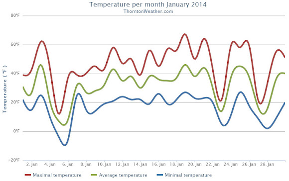
January 2014 could be remembered as a month that brought a weather rollercoaster. Looking back it seems as if we were constantly jumping between mild temperatures to cold to warmth and back to cold again.
The month started out cooler than normal for the first two days with a light shot of snow on New Year’s Day. Temperatures then shot into the 60s on the 3rd but were followed by colder temperatures and more snow on the 4th. On the 5th we registered our coldest day of the month.
From the 7th to the 16th we experienced relatively calm conditions and only very light snow on one day. We saw above normal temperatures from the 15th to the 21st. Two cold days followed with snow falling on the 23rd.
Alternating above-normal and below-normal temperatures closed out the month. Four of the last five days saw snowfall.
Thornton recorded an average monthly temperature of 31.3 degrees. This was slightly higher than Denver’s official recording of 31.2 degrees. Both were slightly above the historical average January temperature of 30.7 degrees.
Temperatures in Thornton ranged from a high of 67.0 degrees on the 19th down to a low of -5.5 degrees on the 6th. Denver’s warmest temperature of 65 degrees also occurred on the 19th and it recorded its coldest of -10 degrees on the 5th.
All 31 days of the month saw low temperatures below freezing in Thornton and four days saw high temperatures fail to reach 32 degrees. Two days saw readings below zero. Denver’s readings were similar with four days staying below freezing and three seeing lows below zero.
Precipitation for the month was nearly double of the Denver historical average thanks to snowfall that was about double of normal.
Thornton recorded 1.06 inch of liquid precipitation, well above the average of 0.41 inch. Denver saw a bit less with 0.94 inch.
While no major snowstorms were seen, there were plenty of smaller events. These gave Thornton 13.4 inches of the white stuff during the month, Denver saw 14.3 inches. Both were about double the January average of 7.1 inches. The official Denver measurement propelled January 2014 into the books as the 11th snowiest January on record.

CLIMATE REPORT
NATIONAL WEATHER SERVICE BOULDER, CO
517 AM MST SAT FEB 1 2014

...................................

...THE DENVER CO CLIMATE SUMMARY FOR THE MONTH OF JANUARY 2014...

CLIMATE NORMAL PERIOD 1981 TO 2010
CLIMATE RECORD PERIOD 1872 TO 2014

WEATHER         OBSERVED          NORMAL  DEPART  LAST YEAR`S
                 VALUE   DATE(S)  VALUE   FROM    VALUE  DATE(S)
                                          NORMAL
................................................................
TEMPERATURE (F)
RECORD
 HIGH              76   01/27/1888
 LOW              -29   01/09/1875
HIGHEST            65   01/19        76     -11       66  01/24
LOWEST            -10   01/05       -29      19      -12  01/12
AVG. MAXIMUM     44.9              44.0     0.9     44.6
AVG. MINIMUM     17.3              17.4    -0.1     16.0
MEAN             31.1              30.7     0.4     30.3
DAYS MAX >= 90      0               0.0     0.0        0
DAYS MAX <= 32      4               5.5    -1.5        6
DAYS MIN <= 32     30              29.4     0.6       30
DAYS MIN <= 0       3               1.7     1.3        5

PRECIPITATION (INCHES)
RECORD
 MAXIMUM         2.35   1883
 MINIMUM         0.01   1933
                        1934
                        1952
TOTALS           0.94              0.41    0.53     0.31
DAILY AVG.       0.03              0.01    0.02     0.01
DAYS >= .01         9               4.1     4.9        4
DAYS >= .10         3               0.9     2.1        1
DAYS >= .50         0               0.0     0.0        0
DAYS >= 1.00        0               0.0     0.0        0
GREATEST
 24 HR. TOTAL    0.26   01/30 TO 01/31           01/28 TO 01/29
                                                          01/29 TO 01/29
                                                          01/29 TO 01/29
 STORM TOTAL       MM                                 MM
 (MM/DD(HH))            MM                    01/29(00) TO 01/29(00)
                                                 01/29(00) TO 01/29(00)9
                                                 01/29(00) TO 01/29(00)9

SNOWFALL (INCHES)
RECORDS
 TOTAL             MM   MM
TOTALS           14.3               7.0

DEGREE_DAYS
HEATING TOTAL    1046              1063     -17     1067
 SINCE 7/1       3497              3531     -34     3300
COOLING TOTAL       0                 0       0        0
 SINCE 1/1          0                 0       0        0

FREEZE DATES
RECORD
 EARLIEST     09/08/1962
 LATEST       06/08/2007
EARLIEST                        10/07
LATEST                          05/05
..........................................................

WIND (MPH)
AVERAGE WIND SPEED              10.7
RESULTANT WIND SPEED/DIRECTION   4/230
HIGHEST WIND SPEED/DIRECTION    36/290    DATE  01/12
HIGHEST GUST SPEED/DIRECTION    44/280    DATE  01/12

SKY COVER
POSSIBLE SUNSHINE (PERCENT)   MM
AVERAGE SKY COVER           0.50
NUMBER OF DAYS FAIR           10
NUMBER OF DAYS PC             14
NUMBER OF DAYS CLOUDY          7

AVERAGE RH (PERCENT)     56

WEATHER CONDITIONS. NUMBER OF DAYS WITH
THUNDERSTORM              0     MIXED PRECIP               0
HEAVY RAIN                0     RAIN                       0
LIGHT RAIN                0     FREEZING RAIN              0
LT FREEZING RAIN          0     HAIL                       0
HEAVY SNOW                2     SNOW                       5
LIGHT SNOW               11     SLEET                      0
FOG                      11     FOG W/VIS <= 1/4 MILE      4
HAZE                      4

-  INDICATES NEGATIVE NUMBERS.
R  INDICATES RECORD WAS SET OR TIED.
MM INDICATES DATA IS MISSING.
T  INDICATES TRACE AMOUNT.
I recall that an ice storm was forecast sometime during the week that Jan 8th, 2014 fell in. I fell and broke my hip due to ice on a walkway at my residence.