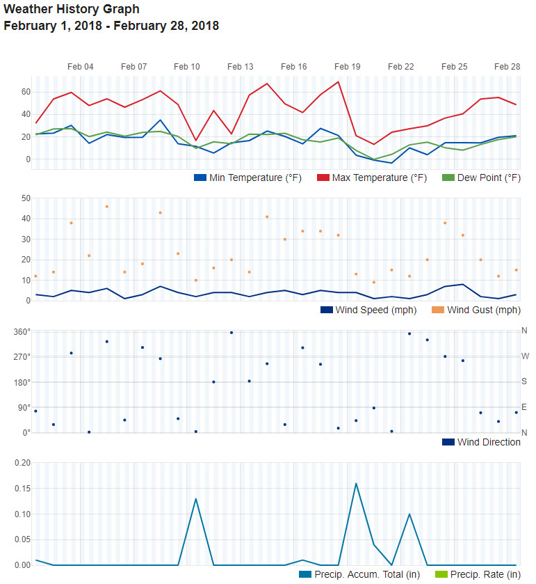
If you felt like the past month was a bit chilly you would be correct. February saw temps a good bit below normal. We did see some help with our lack of seasonal snow and precipitation was a bit above average as well.
The first third of the month continued the dry, warmer than normal conditions we had for much of January. On the 10th of the month we experienced a very cold day and our first snowfall of the month. However, we soon returned to overall dry and warm conditions.
From there we saw things change significantly and quickly. Following an extraordinarily mild day on the 18th, temperature plummeted over the next 48 hours or so. So much so that the high temperature on the 20th was a record low maximum for the date.
Chilly temperatures lingered through the 25th as we saw a week of cold. The 19th, 20th and 22nd also brought snow that helped to add to the seasonal totals.
The final three days of the month saw mercury readings at or above normal.
Overall average temperature for the month of February was 29.2 degrees. At Denver International Airport where the Mile High City’s official records are kept, it was just slightly warmer with an average of 29.9 degrees. Both came a good bit short of the historical February average temperature of 32.5 degrees.
Temperatures in Thornton ranged from a high of 69 degrees on the 18th down to a low of 4 degrees below zero on the 21st. Denver’s highest temperature matched ours while their coldest was 7 degrees below on the 21st.
On average, Denver receives 0.37 inches of precipitation in February. This year, Thornton was a bit above that with 0.45 inches while Denver was below with 0.31 inches.
Both Thornton and Denver saw above average levels of snow although we bested the Mile High City on that front. Thornton recorded 9.5 inches while Denver saw 6.2 inches. Average for the month is 5.7 inches.
Click here to view Thornton’s February 2018 climate report.
From the National Weather Service:
CLIMATE REPORT
NATIONAL WEATHER SERVICE DENVER/BOULDER CO
805 AM MST THU MAR 1 2018

...................................

...THE DENVER CO CLIMATE SUMMARY FOR THE MONTH OF FEBRUARY 2018...

CLIMATE NORMAL PERIOD 1981 TO 2010
CLIMATE RECORD PERIOD 1872 TO 2018

WEATHER         OBSERVED          NORMAL  DEPART  LAST YEAR`S
                 VALUE   DATE(S)  VALUE   FROM    VALUE  DATE(S)
                                          NORMAL
................................................................
TEMPERATURE (F)
RECORD
 HIGH              80   02/10/2017
 LOW              -25   02/01/1951
                        02/08/1936
HIGHEST            69   02/18        66       3       80  02/10
LOWEST             -7   02/21                -6       11  02/26
AVG. MAXIMUM     44.4              46.2    -1.8     53.9
AVG. MINIMUM     15.4              18.9    -3.5     26.6
MEAN             29.9              32.5    -2.6     40.2
DAYS MAX >= 90      0               0.0     0.0        0
DAYS MAX <= 32      6               3.9     2.1        3
DAYS MIN <= 32     26              26.9    -0.9       21
DAYS MIN <= 0       3               1.3     1.7        0

PRECIPITATION (INCHES)
RECORD
 MAXIMUM         2.01   1934
 MINIMUM         0.01   1970
TOTALS           0.31              0.37   -0.06     0.23
DAILY AVG.       0.01              0.01    0.00     0.01
DAYS >= .01         5               5.3    -0.3        3
DAYS >= .10         2               0.7     1.3        1
DAYS >= .50         0               0.0     0.0        0
DAYS >= 1.00        0               0.0     0.0        0
GREATEST
 24 HR. TOTAL    0.14   02/10 TO 02/10           02/23 TO 02/24

 SNOWFALL (INCHES)
RECORDS
 TOTAL            6.2               5.7
RECORD FEBRUARY  22.4                     2015

DEGREE_DAYS
HEATING TOTAL     975               908      67      685
 SINCE 7/1       4057              4439    -382     3802
COOLING TOTAL       0                 0       0        0
 SINCE 1/1          0                 0       0        0

FREEZE DATES
RECORD
 EARLIEST     09/08/1962
 LATEST       06/08/2007
EARLIEST                        10/07
LATEST                          05/05
.................................................................

WIND (MPH)
AVERAGE WIND SPEED              9.9
RESULTANT WIND SPEED/DIRECTION   2/230
HIGHEST WIND SPEED/DIRECTION    38/270    DATE  02/24
HIGHEST GUST SPEED/DIRECTION    47/270    DATE  02/24

SKY COVER
POSSIBLE SUNSHINE (PERCENT)   MM
AVERAGE SKY COVER           0.60
NUMBER OF DAYS FAIR            7
NUMBER OF DAYS PC             12
NUMBER OF DAYS CLOUDY          9

AVERAGE RH (PERCENT)     60

WEATHER CONDITIONS. NUMBER OF DAYS WITH
THUNDERSTORMS 0
HEAVY RAIN             0    MIXED PRECIP            6
LIGHT RAIN           0    RAIN                    0
LT FREEZING RAIN       6    FREEZING RAIN           0
HEAVY SNOW             1    HAIL                    0
LIGHT SNOW            15    SNOW                    6
FOG                   20    FOG W/VIS <=1/4 MILE    9
HAZE                   9

-  INDICATES NEGATIVE NUMBERS.
R  INDICATES RECORD WAS SET OR TIED.
MM INDICATES DATA IS MISSING.
T  INDICATES TRACE AMOUNT.