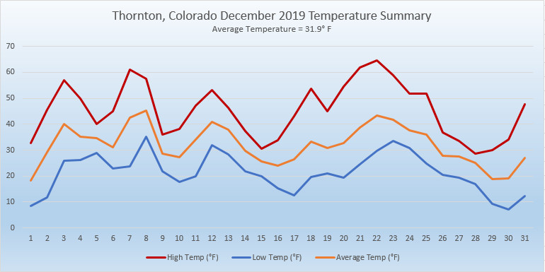
We closed out 2019 with a change from the cool, wet conditions of the previous two months. December saw the opposite conditions as average temperatures were above normal and snow a rarity.
Storm systems did move through Colorado and the Rocky Mountain region and while the high country saw plenty of snow, these storms evaded the Front Range for most of the month. Temperatures were never particularly warm but overall, the average temp was warmer than normal in Thornton.
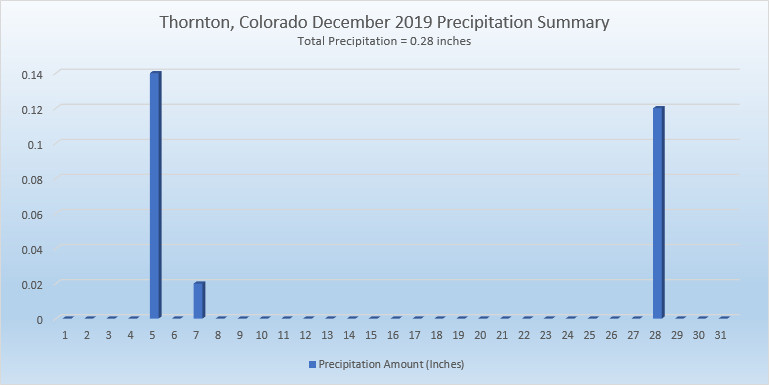
On the 5th of the month, we saw a respectable bit of rain instead of snow. Finally, a light snowfall on the 14th was the first snow of the month. We then stayed dry until the 28th when we received our first – and only – appreciable snowfall of the month.
Thornton’s overall average temperature for the month came in at 31.9 degrees. This was a good bit warmer than Denver’s long term average for December of 30.0 degrees. Out at Denver International Airport where the Mile High City’s official records are kept, it was warmer with an average of 33.7 degrees.
Temperatures in Thornton ranged from a high of 64.6 degrees on the 22nd down to a low of 7.2 degrees on the morning of the 30th. Denver recorded a maximum of 67 degrees and its minimum of 3 degrees on the same dates.
In terms of precipitation, Denver averages 0.35 inches during December. Thornton fell short of that with 0.28 inches while Denver had just a touch more with 0.30 inches.
A mere 2.8 inches of snow was recorded in Thornton during the month and Denver had an identical number. These were well short of the 8.7 inches December typically brings.
Click here to view Thornton’s December 2019 climate report.
CLIMATE REPORT
NATIONAL WEATHER SERVICE DENVER/BOULDER CO
851 AM MST WED JAN 1 2020

...................................

...THE DENVER CO CLIMATE SUMMARY FOR THE MONTH OF DECEMBER 2019...

CLIMATE NORMAL PERIOD 1981 TO 2010
CLIMATE RECORD PERIOD 1872 TO 2019

WEATHER         OBSERVED          NORMAL  DEPART  LAST YEAR`S
                 VALUE   DATE(S)  VALUE   FROM    VALUE  DATE(S)
                                          NORMAL
................................................................
TEMPERATURE (F)
RECORD
 HIGH              79   12/05/1939
 LOW              -25   12/22/1990
                        12/24/1876
HIGHEST            67   12/22        62       5       63  12/21
LOWEST              3   12/30        -4       7        0  12/31
                        12/29
AVG. MAXIMUM     45.3              42.8     2.5     46.1
AVG. MINIMUM     22.1              17.1     5.0     18.8
MEAN             33.7              30.0     3.7     32.5
DAYS MAX >= 90      0               0.0     0.0        0
DAYS MAX <= 32      6               5.8     0.2        4
DAYS MIN <= 32     27              29.4    -2.4       31
DAYS MIN <= 0 0 2.0 -2.0 1 PRECIPITATION (INCHES) RECORD MAXIMUM 5.21 1913 MINIMUM 0.00 1881 TOTALS 0.30 0.35 -0.05 0.03 DAILY AVG. 0.01 0.01 0.00 0.00 DAYS >= .01         2               4.1    -2.1        1
DAYS >= .10         2               1.1     0.9        0
DAYS >= .50         0               0.1    -0.1        0
DAYS >= 1.00        0               0.0     0.0        0
GREATEST
 24 HR. TOTAL    0.18   12/28 TO 12/28           12/31 TO 12/31

SNOWFALL (INCHES)
RECORDS
 TOTAL            2.8               8.7
RECORD DECEMBER  57.4    1913

DEGREE_DAYS
HEATING TOTAL     964              1086    -122      999
 SINCE 7/1       2499              2468      31     2372
COOLING TOTAL       0                 0       0        0
 SINCE 1/1        916               769     147     1026

FREEZE DATES
RECORD
 EARLIEST     09/08/1962
 LATEST       06/08/2007
EARLIEST                        10/07
LATEST                          05/05
.................................................................

WIND (MPH)
AVERAGE WIND SPEED              9.1
RESULTANT WIND SPEED/DIRECTION   4/217
HIGHEST WIND SPEED/DIRECTION    33/350    DATE  12/28
HIGHEST GUST SPEED/DIRECTION    43/270    DATE  12/11

SKY COVER
POSSIBLE SUNSHINE (PERCENT)   MM
AVERAGE SKY COVER           0.50
NUMBER OF DAYS FAIR            7
NUMBER OF DAYS PC             19
NUMBER OF DAYS CLOUDY          5

AVERAGE RH (PERCENT)     56

-  INDICATES NEGATIVE NUMBERS.
R  INDICATES RECORD WAS SET OR TIED.
MM INDICATES DATA IS MISSING.
T  INDICATES TRACE AMOUNT.