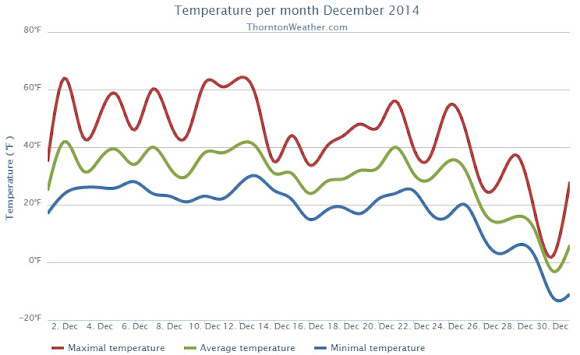
The month of December started out quiet and quite dry. Those mild days however gave way to much colder temperatures during the latter half as well as some nice shots of snow.
For the first 13 days of December 2014, Thornton and the Denver area saw temperatures above normal for the most part. Conditions were dry and calm. On the 14th, our first storm system came in and delivered a quick, light snowfall.
We then entered a calm period that lasted up until Christmas. Temperatures got much colder and some cold temperatures records fell. We also recorded snow on five out of the last seven days of the month.
It was a white Christmas although it wasn’t until late in the day that the white stuff began falling. Denver’s 3.4 inches on the 25th made it the third snowiest Christmas Day on record. Thornton recorded 3.1 inches on the day.
The average temperature for the month in Thornton was 29.2 degrees. Out at the airport, Denver’s official average was a good bit higher at 31.2 degrees. The long term December average is 30.0 degrees.
Thornton’s temperatures ranged from a high of 64.0 degrees on the 12th down to a bone chilling low of -12.1 degrees on the 30th. Denver saw a high mark of 66 degrees and a low of -19 degrees on those days.
Two temperature records were set during the month, both on December 30. A new record low maximum for the date of 1 degree was recorded (old record was 8 degrees set in 1915). Additionally, Denver’s -19 degrees that day was a new record low (old record was -11 degrees set in 1898).
In terms of precipitation, Thornton recorded 0.48 inches of liquid precipitation. Denver was a bit wetter with 0.59 inches. Both readings were above Denver’s December average of 0.35 inches.
On average the Mile High City records 8.5 inches of snowfall during December. In 2014 the month brought 8.8 inches to Thornton while at the airport Denver recorded 12.0 inches.
Click here to view Thornton’s December 2014 climate report.


From the National Weather Service:
CLIMATE REPORT
NATIONAL WEATHER SERVICE BOULDER, CO
1041 PM MST THU JAN 1 2015

...................................

...THE DENVER CO CLIMATE SUMMARY FOR THE MONTH OF DECEMBER 2014...

CLIMATE NORMAL PERIOD 1981 TO 2010
CLIMATE RECORD PERIOD 1872 TO 2014

WEATHER         OBSERVED          NORMAL  DEPART  LAST YEAR`S
                 VALUE   DATE(S)  VALUE   FROM    VALUE  DATE(S)
                                          NORMAL
................................................................
TEMPERATURE (F)
RECORD
 HIGH              79   12/05/1939
 LOW              -25   12/22/1990
                        12/24/1876
HIGHEST            66   12/12        62       4       68  12/18
LOWEST            -19   12/30        -4     -13      -15  12/05
AVG. MAXIMUM     44.1              42.8     1.3     42.9
AVG. MINIMUM     18.5              17.1     1.4     14.0
MEAN             31.3              30.0     1.3     28.4
DAYS MAX >= 90      0               0.0     0.0        0
DAYS MAX <= 32      5               5.8    -0.8        8
DAYS MIN <= 32     31              29.4     1.6       29
DAYS MIN <= 0       2               2.0     0.0        6
PRECIPITATION (INCHES)
RECORD
  MAXIMUM         5.21   1913
  MINIMUM         0.00   1881
TOTALS           0.59              0.35    0.24     0.25
DAILY AVG.       0.02              0.01    0.01     0.01
DAYS >= .01         7               4.1     2.9        7
DAYS >= .10         2               1.1     0.9        1
DAYS >= .50         0               0.1    -0.1        0
DAYS >= 1.00        0               0.0     0.0        0
GREATEST
 24 HR. TOTAL    0.18   12/29 TO 12/30           12/03 TO 12/04

SNOWFALL (INCHES)
RECORDS
 TOTAL           57.4   1913
TOTALS           12.0               8.5

DEGREE_DAYS
HEATING TOTAL    1037              1086     -49     1128
 SINCE 7/1       2291              2468    -177     2451
COOLING TOTAL       0                 0       0        0
 SINCE 1/1        701               769     -68      999

FREEZE DATES
RECORD
 EARLIEST     09/08/1962
 LATEST       06/08/2007
EARLIEST                        10/07
LATEST                          05/05
.....................................................

WIND (MPH)
AVERAGE WIND SPEED              8.7
RESULTANT WIND SPEED/DIRECTION   2/218
HIGHEST WIND SPEED/DIRECTION    41/340    DATE  12/23
HIGHEST GUST SPEED/DIRECTION    52/330    DATE  12/23

SKY COVER
POSSIBLE SUNSHINE (PERCENT)   MM
AVERAGE SKY COVER           0.60
NUMBER OF DAYS FAIR            4
NUMBER OF DAYS PC             19
NUMBER OF DAYS CLOUDY          8

AVERAGE RH (PERCENT)     59

WEATHER CONDITIONS. NUMBER OF DAYS WITH
THUNDERSTORM              0     MIXED PRECIP               0
HEAVY RAIN                0     RAIN                       1
LIGHT RAIN                1     FREEZING RAIN              0
LT FREEZING RAIN          0     HAIL                       0
HEAVY SNOW                1     SNOW                       4
LIGHT SNOW                8     SLEET                      0
FOG                      12     FOG W/VIS <= 1/4 MILE      3
HAZE                      4

-  INDICATES NEGATIVE NUMBERS.
R  INDICATES RECORD WAS SET OR TIED.
MM INDICATES DATA IS MISSING.
T  INDICATES TRACE AMOUNT.
