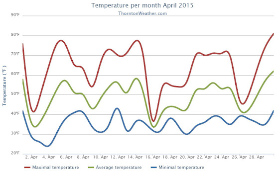
We began the month of April in the need of moisture and while we didn’t do much to bolster our snowfall numbers, rain proved to be a big help. Temperatures were relatively stable but did end up a bit above average.
The first half of the month offered mostly dry conditions and warmer than normal temperatures. The only real exception was a light snowfall on the 2nd and 3rd of the month. Otherwise we saw virtually no precipitation for the first 15 days of April.
The latter half however saw a shift in the weather pattern courtesy of a number of storm systems that moved through. These led to cooler temperatures and some nice shots of precipitation.
A system on the 15th and 16th brought only 3.9 inches of snowfall but a healthy 1.68 inches of liquid precipitation from snowmelt and rain. We then remained mostly dry up until the 26th when another good shot of rain arrived.
Thornton’s average temperature for April 2015 was 49.0 degrees, a good bit above the long term April average of 47.4 degrees. Out at the airport, Denver saw similar readings to ours with an average of 48.7 degrees.
Temperatures in Thornton ranged from a low of 24.0 degrees on the morning of the 4th up to a high of 80.7 degrees on the 30th. Denver’s coldest reading was 27 degrees on the 3rd and its warmest came on the 30th with a temperature of 79 degrees.
In terms of precipitation, Thornton saw 2.68 inches of precipitation for the month. Officially, as measured at DIA, Denver took a very similar 2.65 inches into their bucket. Both readings were a good ways above the April average of 1.71 inches.
Snowfall failed to be anything extraordinary. Both Thornton and Denver saw 5.3 inches of the white stuff, a good bit below the average of 6.8 inches.
Click here to view Thornton’s April 2015 climate report.

From the National Weather Service:
CLIMATE REPORT
NATIONAL WEATHER SERVICE BOULDER, CO
552 AM MDT FRI MAY 1 2015

...................................

...THE DENVER CO CLIMATE SUMMARY FOR THE MONTH OF APRIL 2015...

CLIMATE NORMAL PERIOD 1981 TO 2010
CLIMATE RECORD PERIOD 1872 TO 2015

WEATHER         OBSERVED          NORMAL  DEPART  LAST YEAR`S
                 VALUE   DATE(S)  VALUE   FROM    VALUE  DATE(S)
                                          NORMAL
................................................................
TEMPERATURE (F)
RECORD
 HIGH              90   04/30/1992
 LOW               -2   04/02/1975
HIGHEST            79   04/30                         80  04/22
LOWEST             27   04/03                         18  04/14
AVG. MAXIMUM     62.1              61.5     0.6     62.8
AVG. MINIMUM     35.3              33.3     2.0     35.2
MEAN             48.7              47.4     1.3     49.0
DAYS MAX >= 90      0               0.0     0.0        0
DAYS MAX <= 32      0               0.3    -0.3        0
DAYS MIN <= 32      7              13.0    -6.0       10
DAYS MIN <= 0       0               0.0     0.0        0
PRECIPITATION (INCHES)
RECORD
 MAXIMUM         8.24   1900
 MINIMUM         0.03   1963
TOTALS           2.65              1.71    0.94     1.24
DAILY AVG.       0.09              0.06    0.03     0.04
DAYS >= .01         9               9.1    -0.1        6
DAYS >= .10         6               4.5     1.5        5
DAYS >= .50         2               0.9     1.1        0
DAYS >= 1.00        1               0.5     0.5        0
GREATEST
 24 HR. TOTAL    1.41   04/16 TO 04/17           04/02 TO 04/03

SNOWFALL (INCHES)
RECORDS
TOTAL            33.8   1933
TOTALS            5.3               6.8

DEGREE_DAYS
HEATING TOTAL     481               529     -48      472
 SINCE 7/1       5205              5731    -526     5730
COOLING TOTAL       0                 1      -1        0
 SINCE 1/1          0                 1      -1        0

FREEZE DATES
RECORD
 EARLIEST     09/08/1962
 LATEST       06/08/2007
EARLIEST                        10/07
LATEST                          05/05
....................................................

WIND (MPH)
AVERAGE WIND SPEED              10.7
HIGHEST WIND SPEED/DIRECTION    41/350    DATE  04/15
HIGHEST GUST SPEED/DIRECTION    52/280    DATE  04/12

SKY COVER
POSSIBLE SUNSHINE (PERCENT)   MM
AVERAGE SKY COVER           0.60
NUMBER OF DAYS FAIR            7
NUMBER OF DAYS PC             16
NUMBER OF DAYS CLOUDY          7

AVERAGE RH (PERCENT)     58

WEATHER CONDITIONS. NUMBER OF DAYS WITH
THUNDERSTORM              6     MIXED PRECIP               0
HEAVY RAIN                2     RAIN                       7
LIGHT RAIN               11     FREEZING RAIN              0
LT FREEZING RAIN          0     HAIL                       1
HEAVY SNOW                1     SNOW                       3
LIGHT SNOW                4     SLEET                      0
FOG                      10     FOG W/VIS <= 1/4 MILE      5
HAZE                      3

-  INDICATES NEGATIVE NUMBERS.
R  INDICATES RECORD WAS SET OR TIED.
MM INDICATES DATA IS MISSING.
T  INDICATES TRACE AMOUNT.