When we look back at April 2013 it will be remembered for two key things: the cold and the snow. By both measurements the month saw extremes with temperatures well below normal and well above normal snowfall, the third month in a row we experienced those conditions.
A series of storm systems moved through during April providing regular doses of cold and snow. Three systems from the 9th of the month through the 25th, each coming at the start of the workweeks, provided the notable conditions. Seventeen of those 18 days saw below normal temperatures.
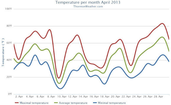
Denver’s official average temperature for the month came in at 41.7 degrees. This was an impressive 5.7 degrees below the 1981 – 2000 historical average. This put April 2013 into the books as the fifth coldest April since recordkeeping began in Denver. Thornton was only slightly better with an April average temperature of 42.3 degrees.
On four days Denver failed to see high temperatures climb above freezing, Thornton registered three such days.
Five cold temperature records were setting during the month. Record lows were set on April 9th, April 10th and April 22nd. The record low was tied on April 16th. A record low maximum was recorded on the 9th as well.
Temperatures ranged from a high of 80 degrees on the 29th down to a low of 6 degrees on the 10th in Denver. Thornton’s temperatures were similar with a high of 81.7 degrees on the 29th and a low temperature for the month of 6.7 degrees on the 10th.
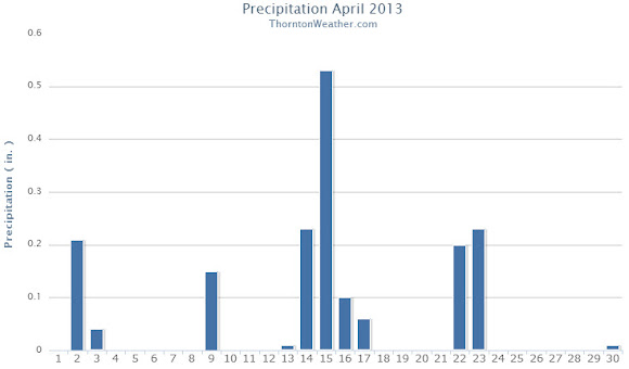
The precipitation was the second half of the April 2013 story with plenty of that falling, primarily in the form of snow.
Denver officially recorded 1.87 inches of liquid precipitation, just a bit above the April average of 1.71 inches. Thornton was just a touch drier with 1.77 inches of precipitation.
Snow was in abundance as Denver saw 20.4 inches of snowfall as measured at Denver International Airport. Thornton was trailing with 19.1 inches. Both marks were well above the Denver April normal of 6.8 inches. Denver’s measurement fell just short of making the list of 10 snowiest Aprils with April 2013 ranking as the 11th snowiest.
Click here to view the ThorntonWeather.com April 2013 Climate Summary
From the National Weather Service:
...THE DENVER CO CLIMATE SUMMARY FOR THE MONTH OF APRIL 2013...

CLIMATE NORMAL PERIOD 1981 TO 2010
CLIMATE RECORD PERIOD 1872 TO 2013

WEATHER         OBSERVED          NORMAL  DEPART  LAST YEAR`S
                 VALUE   DATE(S)  VALUE   FROM    VALUE  DATE(S)
                                          NORMAL
................................................................
TEMPERATURE (F)
RECORD
 HIGH              90   04/30/1992
 LOW               -2   04/02/1975
HIGHEST            80   04/29        83      -3       88  04/24
LOWEST              6   04/10        -2       8       24  04/07
AVG. MAXIMUM     54.7              61.5    -6.8     68.6
AVG. MINIMUM     28.7              33.3    -4.6     37.9
MEAN             41.7              47.4    -5.7     53.3
DAYS MAX >= 90      0               0.0     0.0        0
DAYS MAX <= 32      4               0.3     3.7        0
DAYS MIN <= 32     17              13.0     4.0        4
DAYS MIN <= 0       0               0.0     0.0        0
PRECIPITATION (INCHES)
RECORD
 MAXIMUM         8.24   1900
 MINIMUM         0.03   1963
TOTALS           1.87              1.71    0.16     1.39
DAILY AVG.       0.06              0.06    0.00     0.05
DAYS >= .01        13               9.1     3.9        8
DAYS >= .10         7               4.5     2.5        4
DAYS >= .50         0               0.9    -0.9        0
DAYS >= 1.00        0               0.5    -0.5        0
GREATEST
 24 HR. TOTAL    0.50   04/22 TO 04/23           04/26 TO 04/27

SNOWFALL (INCHES)
RECORDS
 TOTAL           33.8  1933
TOTALS           20.4               6.8

DEGREE_DAYS
HEATING TOTAL     690               529     161      352
 SINCE 7/1       5802              5731      71     5215
COOLING TOTAL       0                 1      -1        6
 SINCE 1/1          0                 1      -1        6

FREEZE DATES
RECORD
 EARLIEST     09/08/1962
 LATEST       06/08/2007
EARLIEST                        10/07
LATEST                          05/05
....................................................

WIND (MPH)
AVERAGE WIND SPEED              11.0
RESULTANT WIND SPEED/DIRECTION   1/016
HIGHEST WIND SPEED/DIRECTION    49/290    DATE  04/14
HIGHEST GUST SPEED/DIRECTION    55/350    DATE  04/08

SKY COVER
POSSIBLE SUNSHINE (PERCENT)   MM
AVERAGE SKY COVER           0.70
NUMBER OF DAYS FAIR            2
NUMBER OF DAYS PC             20
NUMBER OF DAYS CLOUDY          8

AVERAGE RH (PERCENT)     53

WEATHER CONDITIONS. NUMBER OF DAYS WITH
THUNDERSTORM              1     MIXED PRECIP               0
HEAVY RAIN                1     RAIN                       3
LIGHT RAIN               10     FREEZING RAIN              0
LT FREEZING RAIN          0     HAIL                       0
HEAVY SNOW                3     SNOW                       6
LIGHT SNOW                8     SLEET                      0
FOG                      12     FOG W/VIS <= 1/4 MILE      5
HAZE                     11

-  INDICATES NEGATIVE NUMBERS.
R  INDICATES RECORD WAS SET OR TIED.
MM INDICATES DATA IS MISSING.
T  INDICATES TRACE AMOUNT.