Tag Archives: January Weather

Thornton’s January 2022 preview: Cold temps, not much snow the norm

Denver's January weather and climatology preview for 2013.
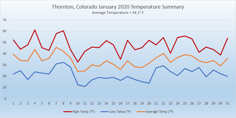
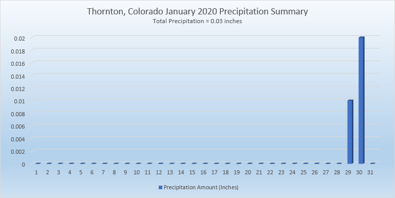
As we begin the new year the winter chill begins to set in.  While January can see its share of extremes, the month historically sees stable temperatures and is usually relatively dry.

January ranks as the second coldest month in Denver next to December with average temperatures remaining virtually the same from the start to the end of the month.

In terms of snowfall, the month only ranks as the sixth snowiest and it is not uncommon for it to be quite dry.

What does January 2022 hold for us?  Follow the link to find out.

For the complete January preview including a look at historical averages and extremes, click here. 

December 26 to January 1: This week in Denver weather history

This Week in Denver Weather History

Winter wind in Colorado can be quite nasty oftentimes reaching damaging levels and we see numerous occurrences of that in our look back at this week in Denver weather history.  Also notable are storm system just a few years ago in 2006 and 2007 that dumped a good amount of snow on the Denver area.

25-26

In 1904…after a warm Christmas Day with a high temperature of 50 degrees…a late day cold front plunged temperatures to a low of 7 degrees…produced northeast winds sustained to 40 mph with gusts to 54 mph…and produced 5.2 inches of snow overnight for a late white Christmas.  The maximum temperature on the 26th was only 16 degrees.

In 2014…a winter storm brought a rare Christmas Day snowfall to the Front Range Foothills and Urban Corridor… from the afternoon of the 25th to the evening of the 26th. Storm totals included: 12.5 inches…4 miles west of Boulder; 12 inches…4 miles southwest of Eldorado Springs and 4 miles south of Golden; 11 inches at Genesee; 10 inches near Allenspark…5 miles west of Chatfield Reservoir…5 miles southwest of Golden and near Tiny Town; 8 inches in Lakewood and Louisville; 7.5 inches in Niwot; 7 inches in Longmont; with 6 inches in Broomfield and Frederick. At Denver International Airport…5.1 inches of snowfall was observed.

25-31

In 1980…temperatures were unusually warm during the week between Christmas and New Year’s.  High temperatures for the week ranged from the mid-50’s to the mid-70’s.  Four temperature records were set.  Record highs occurred on the 26th with 68 degrees…the 27th with 75 degrees…and the 30th with 71 degrees.  A record high minimum temperature of 41 degrees occurred on the 27th.

26

In 1877…heavy snow fell during the early morning and totaled nearly 6 inches.  Precipitation from melted snow was 0.58 inch.  After the snowfall…a number of sleighs were seen on the city streets.

In 1879…after a morning low of 4 degrees below zero… The temperature climbed to a high of 57 degrees in the city.

In 1907…west winds were sustained to 40 mph.  The Chinook winds warmed the temperature to a high of 62 degrees.

In 1949…west winds gusted to 50 mph at Stapleton Airport.

In 1998…intense…but localized…downslope high winds developed near Wondervu in the foothills southwest of Boulder.  Winds frequently gusted to 100 mph with a highest reported wind gust to 104 mph.  West winds gusted to only 43 mph at Denver International Airport.

26-27

In 1954…a major storm dumped heavy snow across metro Denver. Snowfall totaled 8.6 inches at Stapleton Airport.  The storm produced the heaviest snowfall of the calendar year and was the only measurable snowfall in December.

In 1987…a snowstorm stalled in northeastern Colorado…giving metro Denver its worst winter storm in 4 years.  Total snowfall from the storm ranged from 12 to 18 inches on the east side…1 to 2 feet in Boulder County…and 2 to 3 feet in western and southern parts of metro Denver.  The largest reported snowfall was 42 inches at Intercanyon in the foothills southwest of Denver.  Snowfall totaled 14.9 inches at Stapleton International Airport.  Winds were light on the 26th…but increased as high as 40 mph on the 27th… Creating near-blizzard conditions and forcing complete closure of Stapleton International Airport for about 8 hours.  The strong winds whipped drifts to 5 feet high on the east side of town.  All interstate highways leading from Denver were closed on the 27th.

26-28

In 1979 a heavy snow storm dumped 6 to 10 inches of snow over the metro area and 15 to 20 inches at Boulder with up to 2 feet in the foothills west of Boulder.  Heavy snowfall totaled 6.0 inches at Stapleton International Airport where north winds gusted to 21 mph.  Most of the snow… 4.8 inches…fell on the 27th.

27

In 1895…west Chinook winds sustained to 44 mph with gusts to 48 mph warmed the temperature to a high of 52 degrees.

In 1901…an apparent cold front produced sustained north winds to 41 mph with gusts to 48 mph.

In 1957…northwest winds gusting to 52 mph produced some blowing dust across metro Denver.

In 1975…a northwest wind gust to 53 mph was recorded at Stapleton International Airport.

In 1976…a strong pacific cold front moving across metro Denver produced a northwest wind gust to 53 mph at Stapleton International Airport.

In 1990…high winds raked the eastern foothills with a wind gust to 84 mph clocked on Fritz Peak near Rollinsville. The strong northwest winds of 50 to 70 mph whipped newly fallen snow over higher areas into billowy clouds several hundred feet high that could be seen from most locations across metro Denver.

In 1996…another round of high winds developed over portions of the Front Range foothills during the morning hours. Several wind gusts from 70 to 100 mph were reported at Wondervu southwest of Boulder.  West-northwest winds gusted to 38 mph at Denver International Airport.

In 2005…a trained weather observer in Georgetown recorded a wind gust to 94 mph.  No damage was reported.

In 2007…a winter storm brought heavy snow to portions of the urban corridor and adjacent plains.  Storm totals generally ranged from 3 to 7 inches.  Locally heavier bands produced up to 10 inches of snow. In the urban corridor…storm totals included:  10 inches…10 miles south-southeast of Buckley AFB and at Castle Pines; 9.5 inches…4 miles south-southeast of Aurora and Kassler; 7.5 inches…2 miles southeast of Highlands Ranch; 7 inches in Aurora and Sedalia; 6.5 inches in Arvada…4 miles east of Denver and Lafayette; 6 inches in Castle Rock and Thornton.  A measurement of 5.4 inches was taken at the former Stapleton International Airport.  The official total for the month was 20.9 inches; making it the 6th snowiest December on record.

27-28

In 1997…high winds combined with fresh snow from a previous storm caused highways to become slick from drifting snow and near whiteout conditions in localized ground blizzards. Strong winds blew snow across the runways at Centennial Airport…which glazed over and formed areas of ice.  Two planes were damaged when they slid off the runway while landing.  No injuries were reported.  Numerous accidents also occurred on I-25 and I-70 as ice formed under the same conditions.  A rollover accident which injured 4 people on State Highway 93 near the Rocky Flats Environmental Test Facility was also attributed to the high winds.  The high winds caused an office building and showroom under construction in Golden to collapse. The largest wall was 180 feet long and 28 feet high. Some high wind reports included:  86 mph at Golden Gate Canyon…72 mph near Conifer…and 70 mph at Jefferson County Airport and the National Center for Atmospheric Research on the mesa near Boulder.  West-northwest winds gusted to 53 mph at Denver International Airport on the 27th.

In 1998…damaging downslope winds formed in and near the foothills.  Peak wind gusts ranged from 71 to 114 mph. Numerous trees were blown down in Coal Creek Canyon and near Gross Reservoir.  Power lines were blown down… Resulting in scattered outages.  Peak wind reports included:  114 mph at Wondervu…92 mph in Golden Gate Canyon…88 mph in Coal Creek Canyon…and 79 mph 8 miles west of Conifer.  West winds gusted to 46 mph at Denver International Airport on the 28th.

27-29

In 1983…a second surge of bitter cold air in less than a week was less intense.  Record breaking low temperatures of 12 degrees below zero on the 28th and 15 degrees below zero on the 29th were accompanied by 3.7 inches of snowfall and northeast winds gusting to 23 mph.

Continue reading December 26 to January 1: This week in Denver weather history

January 31 to February 6: This week in Denver weather history

This Week in Denver Weather History

Winds can be a blessing and a curse this time of year.  Chinook winds can help warm what is otherwise a normally chilly season.  They can also cause a great deal of damage as they pick up speed as they come roaring across the Front Range.  While we have been lucky thus far this year and not had damaging wind events, looking back at this week in Denver weather history one can’t help but think that maybe it is just a matter of time before they strike.

26-1

In 1888…a protracted warm spell lasted a week.  Maximum temperatures ranged from 62 degrees on the 29th to an all time record high for the month of 76 degrees on the 27th.  Daily record high temperatures of 76…69…and 71 occurred on the 27th…28th…and 30th respectively. Record high minimum temperatures of 47 and 34 occurred on the 26th and 27th.

27-31

In 1951…a major storm dumped 10.1 inches of snowfall at Stapleton Airport.  Most of the snow…8.3 inches…fell on the 29th.  Cold arctic air accompanied the snow.  Several temperature records were set…including record low maximum temperatures of 4 on the 28th and 4 below zero on the 29th and record low temperatures of 12 below zero on the 29th and 24 below zero on the 31st.  Temperatures were below zero for 45 consecutive hours.

29-31

In 1883…a major winter storm dumped 19.3 inches of snow on downtown Denver.  Most of the snow…12.2 inches…fell on the 31st.  This was the heaviest snowfall to hit the city in years.  Temperatures plunged from a high of 52 degrees on the 29th to a low of 13 degrees on the 31st. Precipitation from the storm totaled 2.23 inches.  The 1.22 inches of precipitation on the 31st was the greatest calendar day and 24 hour precipitation ever recorded in the city during the month of January.

30-31

In 1908…an apparent strong cold front plunged temperatures 45 degrees in 24 hours from 47 degrees at noon on the 30th to only 2 degrees at noon on the 31st.  North winds were sustained to 30 mph on the 30th.  Snowfall was only 0.8 inch on the 31st.

In 1965…a major storm dumped 10.4 inches of snow over metro Denver.  After 5 inches of snow fell in Boulder… Strong Chinook winds developed…warming the temperature 25 degrees in 90 minutes.  Wind gusts to 97 mph were recorded on Table Mountain in Boulder.  Winds gusts to 53 mph were measured in downtown Boulder where some damage occurred.  Minor wind damage also occurred in western suburbs of Denver.  West winds gusted to 51 mph at Stapleton International Airport on the 31st.

In 2005…a winter storm brought heavy snow to the Front Range foothills.  Storm totals included:  17 inches at Aspen Springs…13 inches 7 miles southwest of Boulder and at Lake Eldora…12.5 inches near Blackhawk…11.5 inches at Rollinsville and near Nederland…11 inches near Evergreen and Golden and at Gross Reservoir…and 10 inches at Cabin Creek.  Lesser amounts of snow fell over the city.  Only 1.9 inches of snow were measured overnight at Denver Stapleton.  North winds gusted to 30 mph at Denver International Airport…where freezing fog during the early morning of the 30th reduced the surface visibility to as low as 1/8 mile.  Light rainfall… Rare in January…totaled 0.06 inch at Denver Stapleton on the early morning of the 30th.

30-7

In 1985…a cold front on the 29th produced a protracted cold spell as arctic air remained entrenched across metro Denver. While the only daily temperature record set was a low maximum reading of 2 degrees on February 3rd…minimum temperatures plunged well below zero on 9 consecutive days. The coldest readings were 15 degrees below zero on January 31st and 14 degrees below zero on February 5th.

31

In 1876…hurricane force winds caused some damage in Boulder.

In 1951…the low temperature plunged to 24 degrees below zero.

In 1933…snowfall was 0.2 inch in downtown Denver.  This was the only measurable snowfall of the month and resulted in 0.01 inch of melted snow…the only measurable precipitation of the month.

In 1964…high winds blew down a sidewalk cover where a building was under construction…injuring a young woman. Three men were injured when a brick wall at a construction site toppled on them.  All were treated for face…leg…and neck injuries.  A west-northwest wind gust to 47 mph was recorded at Stapleton International Airport.

In 1969…high winds struck Boulder with gusts to 115 mph recorded at the National Center for Atmospheric Research and 83 mph in downtown Boulder.  Schools were closed because of danger from flying debris.  Some damage and minor injuries occurred.  Northwest winds gusted to 35 mph at Stapleton International Airport.

In 1985…bitterly cold weather froze pipes and cars and forced some schools to close across metro Denver.  Minimum temperatures dipped to as low as 15 below to 20 below zero across metro Denver.  The low temperature was 15 below zero at Stapleton International Airport.

31-1

In 1963…high winds struck metro Denver.  The strong Chinook winds reached 101 mph in Littleton…80 mph in Denver…and 90 mph at Rocky Flats.  Among the hardest hit areas were Boulder where buildings under construction were blown down…porches and roofs blown off buildings…and power lines damaged.  Damage totaled 100 thousand dollars in Boulder alone.

In other areas…utility lines were damaged and many signs…antennas…and road markers were blown down.  At Stapleton Airport…west winds gusted to 44 mph on the 31st and 66 mph on the 1st.  The Chinook winds warmed maximum temperatures to 65 degrees on the 31st and to 70 degrees on the 1st.

31-8

In 1963…warm weather that began with the strong Chinook winds on the 31st and 1st continued through the 8th. Maximum temperatures through the period ranged from 52 degrees on the 2nd to 76 degrees on the 5th…which was a new record high for that date.

31-12

In 1899…a protracted cold spell lasted almost two weeks. Low temperatures plunged below zero on all days but February 9th with a reading of 6 degrees.  The coldest low temperature of 22 degrees below zero on February 6th was a record low for the date.  Low temperatures of 20 degrees below zero occurred on both February 11th and 12th… But only the 11th remains as the record minimum for the date.  High temperature of only 5 degrees below zero on February 11th was a record low maximum for the date.  High temperatures climbed to only zero degrees on both February 2nd and 3rd…but were not records.

Intermittent light snow or flurries fell during the period.  The most snowfall…2.0 inches…occurred on February 2nd.

1

In 1904…northwest winds were sustained to 51 mph with gusts to 60 mph.  The Chinook winds warmed the temperature to a high of 55 degrees.

In 1907…west winds sustained to 42 mph warmed the temperature to a high of 59 degrees.

In 1932…the temperature rose from a low of 8 degrees at 7:00 am to the high of 58 degrees at 2:30 pm.  The biggest jump occurred from 16 degrees at 8:00 am to 42 degrees at 9:10 am.

In 1951…the lowest recorded temperature in February…25 degrees below zero…occurred.  The same temperature was also reached on February 8…1936.

In 1963…west-southwest winds gusted to 66 mph at Stapleton Airport where the strong Chinook winds warmed the temperature to a maximum of 70 degrees.

In 1970…snowfall of 0.3 inch contained only 0.01 inch of melted snow.  This was the only measurable snow and precipitation for the month…making it the driest and least snowiest February on record.  Snowfall also was only 0.3 inch on February 22-23…1992…equaling the least snowiest February.

In 1980…high winds occurred in the foothills.  Wind gusts to 75 mph were reported at Wondervu.  Northwest winds gusted to 32 mph at Stapleton International Airport.

In 1995…a short blast of early morning winds near the foothills produced a gust to 64 mph at Rocky Flats in northern Jefferson County.  Winds gusting to 59 mph in Lakewood downed a few tree branches in residential areas. West winds gusted to 37 mph at Stapleton International Airport where the warm winds kept the temperature from falling below 43 degrees…setting a new record high minimum for the date.  The temperature climbed to a non-record high of 63 degrees.

1-2

In 1934…light Chinook winds warmed temperatures to record levels on both days.  Record maximum temperatures reached 73 degrees on the 1st and 74 degrees on the 2nd. West winds were sustained to 18 mph on the 1st.

In 2016…a slow moving storm system produced a deep east to northeasterly upslope flow late in the afternoon of the 1st.  Moderate to heavy snowfall continued through the evening across the rest of Front Range Mountains…Foothills and adjacent plains. Extensive blowing and drifting snow occurred along the Palmer Divide and adjacent plains. Snowdrifts 3 to 6 ft deep were observed. Numerous roads and highways were closed east of the I-25 overnight…including I-70 and I-76…as the roadways became impassable. The road closures continued through the morning of the 2nd as bands of light to moderate snow…with gusty winds to 35 mph persisted. The roads were reopened the afternoon of the 2nd. At Denver International Airport…480 flights were cancelled on the 1st and an additional 125 flights on the 2nd. The official snowfall measurement at Denver International Airport was 11.6 inches…which set a new record for greatest snowfall for the first two days of February.  In the mountains and foothills…storm totals included: 25 inches near Eldorado Springs…24 inches at Genesee and 12.5 miles northwest of Golden…22.5 inches near Nederland…21 inches near Pinecliffe…16.5 inches near Brookvale…14 inches at Intercanyon…13 inches near Berthoud…Echo Mountain and Tiny Town; 12 inches near Conifer and Eldora Ski Area…11 inches at Roxborough State Park…9.5 inches near Golden…9 inches near Bergen Park and Strontia Springs Dam…and 8 inches near Black Hawk.  Across the I-25 Corridor…storm totals included: 19.5 inches near Parker…15 inches near Loveland…14.5 inches near Louisville…14 inches in Arvada and Ken Caryl…13 inches near Federal Heights…Northglenn and Ralston Reservoir; 12 inches in Broomfield…near Buckley AFB…Castle Rock…Erie and Highlands Ranch; 11.5 inches near Westminster…11 inches in southeast Denver…north Longmont…Lafayette and Mead; 10 inches near Aurora… Franktown and Wheat Ridge; 9.5 inches in Thornton…and 9 inches at Frederick.

In 2017…widespread freezing drizzle contributed to numerous road closures and accidents across the Denver area and adjacent plains. Several crashes were reported on Interstate 25…and several cities and counties went on accident alert. Up to 32 delays at Denver International Airport. Numerous school delay openings and some school and business closures were reported over northeast Colorado.

1-3

In 1996…cold arctic air plunged temperatures below zero for more than 35 consecutive hours from late on the 1st until sunrise on the 3rd.  The temperature warmed to only 1 degree below zero on the 2nd after a record low of 16 degrees below zero.

1-4

In 2011…a frigid arctic airmass settled into Front Range urban corridor. At Denver International Airport… Overnight low temperatures…from the 1st to the 3rd… Were 13 below zero…17 below zero and zero respectively. The icy temperatures caused pipes to crack and burst following the freeze. In Loveland…firefighters responded to more than a dozen water pipe breaks…most in fire sprinkler systems at businesses…apartments and assisted care facilities. At CU Earth Science Library in Boulder…more than 1000 books and several costumes for an upcoming production were damaged. At the county courts administration building in Jefferson County…a steady stream of water from a crack on the 5th floor… Went unnoticed on the 3rd and flooded all the floors of the administration wing overnight. As a result…much of the office equipment…furniture and carpet sustained water damage. A burst sprinkler line caused minor damage at the Platte Valley Medical Center in Brighton. The icy temperatures forced to closure of several school districts as well.

1-5

In 1985…the most bitter cold spell of the winter season brought sub-zero temperatures to metro Denver.  Daily low temperature records were broken at Denver.  The usual cold weather problems struck including stalled vehicles…jammed traffic lights…and frozen water and sewer lines.  At Stapleton International Airport…the high temperature was only 2 degrees above zero on the 1st…setting a record low maximum for the date.  Low temperatures reached 13 below zero on the 1st…12 below on the third…and 14 below on the 5th.

1-6

In 1989…one of the century’s worst doses of winter weather ravaged the entire state.  Bitterly frigid weather moved into metro Denver on the 1st as snow buried many sections of the state.

In metro Denver where 3 to 6 inches of snow fell…blowing snow and resultant poor visibilities caused a 46-car pile-up on I-25 in the middle of the city on the 4th.  During the period…2 to 3 hour delays were common at Stapleton International Airport where snowfall from the storm totaled 4.3 inches and northeast winds gusted to 30 mph on the 1st.

Intense cold accompanied the storm. Temperatures in Denver stayed below zero continuously for the best part of 3 days (3rd…4th…5th)…for a total of 69 hours.  This is the fourth longest sub-zero period on record.  Wind chill temperatures reached 50 degrees below zero.  The mercury dipped to 24 degrees below zero on the 5th…setting a record for the date.  This was the city’s coldest temperature in over 26 years.  Low temperatures dipped below zero on 8 consecutive days (2nd-9th).  High temperature of 9 degrees below zero on the 4th was a record low maximum for the date…as was the high of 5 degrees on the 5th.  Extensive damage occurred when pipes and water lines froze and broke.  Thousands of cars failed to start. On the 3rd…a 57-year-old woman died of hypothermia in an Arvada park.  Eighteen high school students were treated for hypothermia after a 2-hour ride through Jefferson County in an unheated bus.  At least 2 cases of frostbite were reported; there were undoubtedly many more.

1-9

In 1883…a protracted cold period occurred when low temperatures dipped below zero for 9 consecutive days. Low temperatures ranged from 22 degrees below zero on the 4th to 2 degrees below zero on the 1st and 6th.  High temperatures ranged from 10 below zero on the 3rd to 23 on the 9th.  Several temperature records were set that still stand today.  Record lows of 18 below and 22 below zero occurred on the 3rd and 4th.  Record low maximum readings of 2 below and 10 below zero occurred on the 2nd and 3rd.  The high of only 10 below zero on the 3rd is the coldest maximum temperature ever recorded in Denver.

Continue reading January 31 to February 6: This week in Denver weather history

January 2021 top shots: Monthly photo slideshow

A bald eagle fishes a pond in Thornton. (Ed Dalton)

As one of our coldest months, January can be a good month to hibernate inside and avoid the outdoors.  But, like any month in Colorado, photo opportunities abound as our monthly slideshow demonstrates.

Snow is not normally dominant in the month but when it does fall, it can create a beautiful blanket of white.  Throw in the amazing sunrises and sunsets we receive in the middle of winter as well as wildlife and a host of other subjects and the imagery can be quite beautiful and stunning.

  • Slideshow updated January 31, 2021
  • To learn more about how to send your photo to us for inclusion in the slideshow, see below the slideshow.

Showcasing images captured by ThorntonWeather.com readers as well as some of our own, our monthly slideshow covers the entire gamut of weather-related imagery.

Sunsets, sunrises, wildlife and of course every type of weather condition are vividly depicted in images captured from yours and our cameras.

[flickr_set id=”72157717743498126″]

What is missing in the slideshow above?  Your photo!

Our monthly photo slideshow is going to feature images that we have taken but more importantly images that you have captured.  The photos can be of anything even remotely weather-related.

Landscapes, current conditions, wildlife, pets, kids.  Whimsical, newsy, artsy.  Taken at the zoo, some other area attraction, a local park, a national park or your backyard.  You name it, we want to see and share it!

Images can be taken in Thornton, Denver or anywhere across the extraordinary Centennial State.  We’ll even take some from out of state if we can tie it to Colorado somehow.

We’ll keep the criteria very open to interpretation with just about any image eligible to be shown in our slideshows.

What do you win for having your image in our slideshow?  We are just a ‘mom and pop’ outfit and make no money from our site so we really don’t have the means to provide prizes.  However you will have our undying gratitude and the satisfaction that your images are shared on the most popular website in Thornton.

To share you images with us and get them included in the slideshow just email them to us or share them with ThorntonWeather.com on any of the various social media outlets.  Links are provided below.

So come on, get those camera’s rolling!

January 24 to January 30: This week in Denver weather history

This Week in Denver Weather History

Denver and Colorado weather is rarely boring. This week in Denver weather history we see numerous occurrences of Chinook winds that warmed temperatures but also arrived with such force that they caused a great deal of damage. We also see unseasably warm weather, bitter Arctic cold, and snow fall that had to be measured in feet.

From the National Weather Service:

18-24

In 2005…a week of mid-winter unseasonably warm weather pushed high temperatures into the 60’s or more on all but one day. During the period…the highest temperature of 70 degrees on the 20th was a new record maximum for the date. Low temperatures remained above freezing on 4 of the days.

22-26

In 1948…the longest period of snowfall on record (92 hours and 3 minutes) occurred in downtown Denver where a total of 13.6 inches of snow fell. At Stapleton Airport…19.0 inches of snow fell…making it the heaviest snow in January and the 5th heaviest snow of record at that time. North winds were sustained to a velocity of 23 mph on the 25th…but generally the winds were light throughout the storm. The snow disrupted traffic…but street clearing was begun soon after it became apparent that the snow would be heavy. Over the 5 days…temperatures ranged from a high of 48 degrees on the 22nd to a low of 1 degree on the 26th. Most readings were in the teens and 20’s during the storm.

23-24

In 1921…heavy snowfall in downtown Denver totaled 8.0 inches overnight. Northwest winds were sustained to 22 mph with gusts to 25 mph on the 24th.

24

In 1887…west winds sustained to 44 mph warmed the temperature to a high of 56 degrees in the city.

In 1890…northwest winds sustained to 48 mph with gusts to 60 mph warmed the temperature to a high of 63 degrees.

In 1900…west winds were sustained to 44 mph with an extreme velocity of 46 mph. The Chinook winds warmed the temperature to a high of 57 degrees.

In 1934…a trace of snowfall resulted in precipitation of 0.01 inch in downtown Denver. This was the only measurable amount of precipitation for the month…making the month one of the driest January’s on record.

In 1956…west-northwest winds gusted to 51 mph at Stapleton Airport. Strong and gusty winds persisted throughout the day.

In 1972…a west wind gust to 92 mph was recorded in Boulder at the National Bureau of Standards…while in downtown Boulder a wind gust to only 66 mph was measured.

In Denver…a car was demolished when the wind blew a traffic light pole onto it…and a wooden wall at a construction site was blown over damaging two cars. Northwest winds gusted to 55 mph at Stapleton International Airport.

In 1982…strong winds were again reported along the eastern foothills. While the most damage occurred in the Fort Collins area…Boulder did not entirely escape. Nine planes were damaged at the Boulder airport along with 4 mobile homes and many cars in the Boulder area. A school in Central City was damaged. A water tank in Parker collapsed. The strongest wind gust recorded was 140 mph at Wondervu. Wind gusts reached 92 mph in Boulder. Northwest wind gusts to 61 mph were recorded at Stapleton International Airport.

In 1992…for the third day…high winds raked the eastern foothills. Winds gusted to 105 mph at the National Center for Atmospheric Research in Boulder. Several tractor trailers were overturned along State Highway 93…between Boulder and Golden. Traffic lights and signs were knocked down in Boulder. Other wind reports included: 86 mph at Rocky Flats…100 mph on Fritz Peak near Rollinsville…and 93 mph in north Boulder. West winds gusted to 37 mph at Stapleton International Airport.

24-25

In 1916…a trace of light rain…rare in Denver for January… Occurred on both days.

In 1946…high winds occurred in Boulder and along the foothills to the north. A wind gust to 72 mph was recorded at Valmont.

In 1947…strong winds were measured in Boulder. Hourly wind gusts averaged 72 mph at Valmont east of Boulder.

In 1950…heavy snowfall totaled 7.1 inches at Stapleton Airport and 6.8 inches in downtown Denver.

24-26

In 1970…a wind gust to 122 mph was recorded at the National Center for Atmospheric Research in Boulder on the 24th. Winds also gusted to 109 mph at NCAR on the 26th. Most winds were estimated between 60 and 70 mph in Boulder. Damage…in most cases…was from broken windows and tree limbs and downed power lines. A roof was blown off a house in Eldorado Springs south of Boulder. A building under construction was damaged in Boulder. Reported damage totaled 25 hundred dollars in Boulder. Northwest winds gusted to 47 mph at Stapleton International Airport on the 24th. In Denver…the Chinook winds warmed the temperature to a record high of 68 degrees on the 24th.

25

In 1872…the greatest temperature change in one day…66 degrees…from a low of 20 degrees below zero…a record low for the date…to a high of 46 degrees…occurred.

In 1888…west winds sustained to 42 mph warmed the temperature to a high of 58 degrees.

In 1890…northwest Chinook winds gusting as high as 48 mph resulted in two temperature records. High temperature of 72 degrees was a record maximum for the date. Low temperature of only 48 degrees was a record high minimum for the date.

In 1914…Chinook winds from the northwest sustained to 46 mph with gusts as high as 60 mph warmed the temperature to a high of 52 degrees. The low temperature was only 39 degrees.

In 1923…snowfall of 1.3 inches was the only measurable snow of the month.

In 1931…snowfall of 0.1 inch was the only measurable snow of the month. The melted snow totaled only 0.02 inch of precipitation…which was the only measurable amount of the month. This resulted in the 4th driest January on record.

In 1964…high winds occurred in Boulder…Golden…and Broomfield where a wind gust to 80 mph was recorded at Jefferson County Airport. Some power lines were downed. Damage to buildings and vehicles was also reported. West-northwest winds gusted to 46 mph at Stapleton International Airport.

In 1971…the highest recorded wind gust in the state of Colorado…147 mph…occurred at the National Center for Atmospheric Research on the mesa in southwest Boulder. Wind gusts to 91 mph were measured at the National Bureau of Standards and to 87 mph in downtown Boulder. A wind gust to 75 mph was recorded at Jefferson County Airport in Broomfield. The strong winds caused widespread minor damage in Boulder. Northwest winds gusting to 32 mph at Stapleton International Airport warmed the temperature to a high of 55 degrees.

In 1980…a blizzard struck Denver right at the evening rush hours…causing massive traffic snarls and forcing the closure of I-25 north of Denver and I-70 east of the city as well as many other roads. Hundreds of travelers were stranded. Multi-car accidents involving as many as 50 cars were common. Air traffic at Stapleton International Airport was stalled for 3 hours. Winds gusted to 50 or 60 mph with visibility reduced to zero at times. The high winds knocked out electrical power in Broomfield. During the height of the storm…temperatures plunged from the freezing mark at mid-afternoon to only 5 degrees before midnight. Initial snowfall from the storm was only 3 to 5 inches across metro Denver with 4.1 inches measured at Stapleton International Airport where north wind gusts to 58 mph were recorded.

In 1988…high winds pummeled the eastern foothills with a peak gust to 96 mph recorded near Rollinsville. A gust to 109 mph was recorded at Echo Lake. West winds gusted to 48 mph at Stapleton International Airport.

In 1996…heavy snow fell along the Front Range foothills. Snow accumulations of 4 to 8 inches were measured from I-25 west into the foothills with lighter accumulations reported elsewhere. Snowfall totaled only 0.9 inch at the site of the former Stapleton International Airport.

In 2004…locally heavy snow fell across metro Denver. The heaviest snow was south of Denver and in the foothills. Snowfall totals included: 9 inches near Indian Hills… 8.5 inches near Franktown and 9 miles southwest of Sedalia…8 inches 7 miles southwest of Aurora…and 6 inches in Highlands Ranch. Snowfall was only 2.8 inches at the site of the former Stapleton International Airport. North winds gusted to 35 mph at Denver International Airport

In 2008…strong westerly winds blew out three windows at a Chipotle restaurant in Louisville. Two people were taken to the hospital for minor cuts. At Denver International Airport…northeast winds gusted to 35 mph.

25-26

In 1910…gale force westerly winds of great velocity struck Boulder. Some damage was reported. West winds were sustained to 45 mph in Denver on the 25th.

Continue reading January 24 to January 30: This week in Denver weather history

January 17 to January 23: This week in Denver weather history

This Week in Denver Weather History

Chinook winds in January oftentimes bring welcome warmth to the Front Range.  They can however be more of a curse than a blessing as at times they can reach hurricane strength and do extensive damage.  Looking back at this week in Denver weather history, we see many such occurrences.

From the National Weather Service:

14-21

In 1930…a protracted cold spell occurred when low temperatures plunged below zero on 8 consecutive days.  The coldest low temperatures of 20 degrees below zero on the 17th and 19 degrees below zero on the 16th were record minimums for the dates.  High temperatures during the period ranged from 18 on the 18th to zero on the 20th.  Two degrees on the 15th was a record low maximum temperature for the date.

15-23

In 1962…a protracted cold spell kept metro Denver in the deep freeze for more than a week.  From the 15th thru the 23rd…low temperatures were zero or below for 9 consecutive days…but a daily record low was set only on the 22nd when the temperature dipped to 14 degrees below zero.  A record low maximum for the date was also set on the 22nd when the temperature climbed to only 11 degrees.  The coldest high temperature was 3 degrees above zero on the 21st…which did not break the record.  The protracted cold was broken for only a few hours on the afternoon of the 20th when Chinook winds warmed the temperature to a high of 38 degrees before another surge of cold arctic air plunged temperatures back into the deep freeze that evening.  The severe cold caused much damage to water systems.  A woman was frozen to death at Morrison.  There were other deaths attributable to the weather…including traffic deaths and heart attacks from overexertion.

16-17

In 1886…a brief cold spell resulted in two temperature records.  High temperatures of zero degrees on the 16th and 2 degrees below zero on the 17th were both record low maximums for the dates.  Low temperatures of 8 degrees below zero on the 16th and 16 degrees below zero on the 17th were not records.

In 1930…temperatures plunging well below zero resulted in two records.  Low temperatures of 19 degrees below zero on the 16th and 20 degrees below zero on the 17th were record low temperatures for the dates.  High temperatures were 4 degrees on the 16th and 15 degrees on the 17th.  Light snowfall totaled 4.0 inches.  North winds were sustained to 18 mph on the 16th.

In 1964…high winds struck the eastern foothills.  Gale velocity winds were recorded in Boulder with gusts to 83 mph measured at Rocky Flats.  Several airplanes were damaged at the Jefferson County Airport in Broomfield. Roofs…walls…and parts of buildings were blown away at various locations.  Power poles and trees were blown over.

16-18

In 1943…light snowfall totaled 3.2 inches over the 3 days. This was the only measurable snow of the month.  North winds were sustained to 20 mph on the 16th.

In 2011…very strong winds associated with an upper level jetstream over Colorado produced blizzard conditions in the mountains above timberline. Peak wind gusts included: 99 mph atop Loveland pass…94 mph… 2 miles southwest of Mary Jane…80 mph atop Berthoud Pass and 79 mph atop Niwot Ridge. Storm totals in the ski areas west of Denver ranged from 8 to 14 inches.

17

In 1872…light snow fell during the morning and continued into the afternoon until 3:30 pm.  The sky commenced to clear a little before 2:00 pm…but snow fell thickly for at least half an hour even though the sky was perfectly clear overhead.  Melted snow totaled 0.33 inches.

In 1888…northwest winds were sustained to 46 mph in the city.

In 1905…intermittent rain…unusual in January…occurred during the day.  The rain changed to snow during the late evening…but ended before midnight.  Snowfall was 2.0 inches. Precipitation totaled 0.62 inch.  The temperature ranged from a high of 44 degrees to a low of 32 degrees.

In 1950…wind gusts to 62 mph caused some blowing dust at Stapleton Airport.

In 1982…one of the worst wind storms in many years hit the Front Range foothills.  The strongest winds occurred in Boulder where at 2:30 am a wind gust to 147 mph was recorded at the National Center for Atmospheric Research…on the mesa in southwest Boulder.  At this location 20 wind gusts over 120 mph were clocked between 1:00 am and 9:00 am.  An estimated 40 percent of all buildings in Boulder received at least minor wind damage.  About 50 homes were damaged enough to be uninhabitable.  At least 15 homes in the Table Mesa area of Boulder lost roofs.  Twenty small airplanes were destroyed at the Boulder airport.  Utility poles were snapped in two…and about one-seventh of the buildings in the area were without power.  Insured damage totaled 20 million dollars making the wind storm the most costly on record in Colorado at the time.

In 1989…high winds were recorded along the eastern foothills with gusts to 90 mph recorded at Rollinsville.  North of Denver on I-25…the wind injured two men when their tractor trailer was blown off the road and rolled.  West winds gusted to 48 mph at Stapleton International Airport.

In 1990…an intense but localized snow storm caught many people by surprise when it dumped 3 to 6 inches of snow during a 3-hour period across portions of Boulder County. The storm swath approximately 20 to 30 miles wide stretched northeast from Boulder to just east of Longmont.  Only light snow fell over the remainder of metro Denver with 0.2 inch of snowfall measured at Stapleton International Airport where northeast winds gusted to 30 mph.

In 1998…strong winds in the foothills spread over the plains mainly north of metro Denver.  Winds gusted to 75 mph at Golden Gate Canyon.  West winds gusted to 34 mph at Denver International Airport.

17-18

In 1974…rare overnight January rainfall totaled 0.12 inch on the 17th and 0.26 inch on the 18th when it was briefly mixed with snow.

In 2012…damaging winds developed in and near the Front Range. In Boulder…the high winds knocked down several trees… Power poles and electrical lines. Some of the fallen trees damaged homes and automobiles. A semi-trailer was blown on its side along State Highway 93 near Marshall. Peak wind gusts included: 104 mph in south Boulder; 98 mph…3 miles southwest of Pinecliffe; 95 mph…2 miles northwest of Rocky Flats; 92 mph…at State Highway 93 near Marshall; 87 mph at Berthoud Pass and in Boulder Canyon; 80 mph…5 miles west- northwest of Boulder; 83 mph at NCAR Mesa Lab; 78 mph…8 miles northeast of Four Corners; 79 mph at the National Wind Technology Center; 76 mph at Wondervu; 75 mph atop Loveland Pass and the NCAR foothills lab in Boulder; 74 mph at Blue Mountain…Boulder Municipal Airport… 1 mile northwest of Lyons; 73 mph…4 miles east-northeast of Nederland; 72 mph at the junction of State Highways 72 and 93; 62 mph in Superior; and 61 mph at Erie Municipal Airport. A peak wind gust of 38 mph from the northwest was observed at Denver International Airport.

18

In 1874…light rain…rare in January…changed to snow which totaled 3 inches.

In 1959…strong gusty winds caused damage to buildings… Airplanes…trees…and a radio tower in Boulder… Broomfield…Denver…and Longmont.  A wind gust to 70 mph was recorded in Longmont.  In Boulder…the top of a radio tower was toppled and signs…trees…and trailer houses were blown over.  In southwest Denver…a mother and child were injured when their car was struck by a sign that had blown loose in the wind.  Minor damage to buildings and power lines was reported in the area.  Northwest winds gusted to 38 mph at Stapleton Airport.  Post-frontal east northeast winds gusted to 40 mph.

In 1961…northeast winds gusted to 29 mph and snowfall totaled only 0.1 inch at Stapleton Airport…but 2 to 7 inches of snow fell in the foothills west of Denver.

In 1975…a strong cold front roared through metro Denver producing north wind gusts to 52 mph and briefly reducing the visibility at Stapleton International Airport to less than 5/8 mile in blowing dust.  The windstorm caused considerable damage to utility lines…homes…fences… Commercial buildings…autos…and schools.  Heaviest damage was near the foothills where winds hit 80 mph at Boulder and at Rocky Flats northwest of Denver. The cold front caused temperatures to drop 13 degrees in one hour.  Temperatures fell from a maximum of 61 degrees in the early afternoon to a minimum of 31 degrees before midnight.

In 1984…the coldest morning of the new year produced record breaking temperatures with a low of 19 degrees below zero for the date at Denver.  Many other cities also reported record cold.

In 1985…highs winds occurred in the foothills with gusts reported to 60 mph at Evergreen.  Northwest winds gusted to 38 mph at Stapleton International Airport.

In 1986…wind gusts to 60 mph were reported in Boulder. West winds gusted to 31 mph at Stapleton International Airport.

In 1999…damaging downslope winds caused problems in the foothills.  In Eldora…the roof was blown off an a-frame house.  Peak wind gusts included:  100 mph at Central City…84 mph at Wondervu…77 mph atop Blue Mountain… 75 mph in Golden Gate Canyon…72 mph at the Rocky Flats Environmental Test Facility…and 70 mph at the National Center for Atmospheric Research Mesa Laboratory near Boulder.  West winds gusted to 36 mph and warmed the temperature to a high of 63 degrees…the highest reading of the month at Denver International Airport.

In 2006…high winds occurred in northern Jefferson and southern Boulder counties.  A peak wind gust to 81 mph was recorded near superior along with a gust to 80 mph near Boulder.  Five teenagers started a grassfire near Plainview atop Rocky Flats.  The high winds coupled with very dry conditions allowed the fire to quickly spread…forcing the evacuation of dozens of residents and the closure of State Highways 93 and 72.  The fire consumed 2700 acres and destroyed two outbuildings.  No homes were damaged and no one was injured by the blaze. West winds gusted to 30 mph at Denver International Airport.

18-19

In 1980…a slow moving storm deposited 4 to 10 inches of snow across metro Denver with the greatest amounts in the foothills.  Flights were delayed 30 to 40 minutes at Stapleton International Airport where snowfall totaled 5.5 inches and north winds gusted to 22 mph.

In 1988…a blizzard produced strong winds and heavy snow across eastern Colorado.  Ten-foot drifts were common and many roads were closed including I-70…I-76…and I-25. In the Denver area…4.0 inches of snow fell at Stapleton International Airport where north winds gusting to 40 mph reduced the visibility to 1/2 mile at times.

18-20

In 1958…snowfall totaled 6.9 inches at Stapleton Airport where east-northeast winds gusted to 26 mph on the 18th.

18-24

In 2005…a week of mid-winter unseasonably warm weather pushed high temperatures into the 60’s or more on all but one day.  During the period…the highest temperature of 70 degrees on the 20th was a new record maximum for the date.  Low temperatures remained above freezing on 4 of the days.

Continue reading January 17 to January 23: This week in Denver weather history

January 10 to January 16: This week in Denver weather history

This Week in Denver Weather History

January weather is like the weather of any other month in Denver  in that you can see just about any type of condition possible.  However, three conditions are dominant during the month – wind, snow and cold.  All three make many appearances in our look back at this week in Denver weather history.

From the National Weather Service:

7-10

In 1962…a major winter storm dumped 13.5 inches of snow on metro Denver.  A foot of the snow fell on the 8th when northeast winds gusted to 30 mph.  The storm was followed by an intense blast of very cold arctic air.  Minimum temperature readings of 24 degrees below zero occurred on both the 9th and 10th.  The temperature never reached above zero on the 9th when a maximum reading of 1 degree below zero was recorded.  Temperatures were below zero for 37 consecutive hours.

8-10

In 1983…winds of 70 to 90 mph howled through Boulder. A wind gust to 100 mph was recorded on Fritz Peak near Rollinsville.  A tree blown down by the wind damaged a house in eastern Boulder County.  The strong winds developed behind a cold front late on the 8th and continued through the 10th.  At Stapleton International Airport…west to northwest winds gusted to 49 mph on the 8th…to 45 mph on the 9th…and to 48 mph on the 10th.

9-10

In 1962…the low temperature plunged to 24 degrees below zero on both days.

In 1972…a west wind gust to 60 mph was recorded at Stapleton International Airport…while in Boulder a wind gust to 86 mph was recorded at the National Bureau of Standards. The roof of a house was blown off…and trees were blown down in Boulder.  The high winds contributed to the damage from a building fire in Boulder.

In 2000…heavy snow and strong winds in the mountains spilled into the Front Range foothills.  Ward…northwest of Boulder…received 9 inches of new snow.  Wind gusts to 91 mph were measured in Golden Gate Canyon…with gusts to 77 mph at Loveland Ski Area and to 73 mph along State Highway 93 north of Golden.  West winds gusted to 44 mph at Denver International Airport on the 9th.

In 2011…a winter storm brought moderate to heavy snowfall to areas in and near the Front Range foothills and Palmer Divide. Storm totals included: 13 inches…3 miles south of Golden; 11.5 inches near Eldorado Springs…10.5 inches… 2 miles southwest of Boulder; 10 inches…3 miles southwest of Roxbourough State Park; 9 inches at Genessee…8.5 inches in Arvada…4 miles south-southeast of Bennett and greenwood village…8 inches… 8 miles south of Elizabeth; 7 inches at Commerce City and 6.5 inches near Louisville and at Denver International Airport. Gusty winds produced snow drifts up to 2 feet deep over the Palmer Divide.

10

In 1893…strong west winds in Boulder and the adjacent foothills caused only minor damage.

In Denver…northwest winds were sustained to 48 mph with gusts as high as 60 mph.  The Chinook winds warmed the temperature to a high of 64 degrees and a low of only 40 degrees…which was a record high minimum for the date.

In 1911…southwest Chinook winds sustained to 44 mph warmed the temperature to a high of 60 degrees.

In 1932…the first thunderstorm ever officially recorded in Denver during January occurred in the early morning. The assistant observer heard two prolonged peals of thunder between 4:20 am and 4:25 am.  Another off-duty observer was awakened by the thunder.  Other people reported both thunder and lightning.  Light snow was falling at the time.  Pellets of graupel or hail were reported from some parts of the city.  Snowfall totaled only 1.8 inches.  Northwest winds gusted to 30 mph.

In 1962…as the temperature dipped to a frigid 24 degrees below zero…setting a new record minimum for the date… The pressure adjusted to sea level reached the highest ever recorded in Denver…31.24 inches (1057.8 mb).  The altimeter setting reached 30.70 inches…and the actual station pressure recorded was 25.260 inches.

In 1988…strong winds occurred throughout the day in and near the foothills.  Peak gusts to 85 mph were recorded at Rollinsville…84 mph at Echo Lake…and 64 mph in Boulder.

In 1990…a third consecutive day of 50 to 85 mph wind gusts occurred in and along the eastern foothills.  A 5 mile portion of the Denver-Boulder turnpike was closed after clouds of blowing dust and gravel caused several multicar accidents near Broomfield.  One 59-year-old woman was killed and two others injured.  A wind gust to 81 mph was recorded at the nearby Jefferson County Airport. In Boulder…wind gusts to 85 mph were blamed for ripping off a portion of a roof on a house…as well as blowing out the large picture window.  West winds gusted to 41 mph at Stapleton International Airport.  The warm Chinook winds set a record high temperature of 71 degrees in Denver for the date.

In 1996…strong northwest winds developed behind a pacific cold front that moved rapidly across northeast Colorado. A peak wind gust to 64 mph was recorded at the Rocky Flats Environmental Test Facility in Jefferson County.  North- northeast winds gusted to 38 mph at Denver International Airport.

10-11

In 1948…strong winds were reported in Boulder and Lakewood. Winds of 50 to 60 mph were reported at Valmont…just east of Boulder.  Only minor damage was reported.

In 1980…strong winds of 60 to 95 mph howled across metro Denver…causing some brief power outages and some broken windows.  A wind gust to 111 mph was recorded at Wondervu. Northwest winds gusted to 40 mph at Stapleton International Airport on the 10th.

In 1999…high winds gusting to 100 mph blasted the foothills. Peak wind gusts included:  100 mph at central city…98 mph at Wondervu…82 mph at Aspen Springs and Golden Gate Canyon… 81 mph at the NCAR Mesa Lab in Boulder and near Nederland… 78 mph atop Blue Mountain near Coal Creek Canyon…and 72 mph at the Rocky Flats Environmental Test Facility.  West winds gusted to 38 mph and warmed the temperature to a high of 63 degrees at Denver International Airport on the 11th.

10-12

In 1997…heavy snow fell over the Front Range foothills. A foot of new snow was measured at Blackhawk with 7 inches recorded in Coal Creek Canyon.  Only 3.3 inches of snow fell at the site of the former Stapleton International Airport.  East-northeast winds gusted to 18 mph at Denver International Airport on the 11th.

10-13

In 1963…a arctic cold wave plunged temperatures well below zero across metro Denver.  Temperatures were below zero for a total of 64 consecutive hours.  Low temperatures reached 25 degrees below zero on both the 11th and 12th.  The high temperature of 9 degrees below zero on the 11th was the coldest ever recorded at Stapleton Airport and equaled the record low maximum for the month first set on January 19…1883…in downtown Denver.  The high temperature on the 12th reached only 1 degree below zero.  On the 12th…an 18-year-old youth died of exposure from the extreme cold in Denver.  There were many losses and damage to property from frozen water systems…stalled cars…and over-burdened heating systems.  Light snow accompanied the arctic blast. At Stapleton Airport…2.3 inches of snow fell on the 10th and 11th.

11 Continue reading January 10 to January 16: This week in Denver weather history

January 3 to January 9: This week in Denver weather history

This Week in Denver Weather History

January weather in Colorado can be as varied as during any month of the year.  Temperatures bordering on spring-like to bone chilling Arctic cold can be seen.  Snow of course plays a big part and while not always recognized as a big danger, high speed damaging winds are not unusual.

31-6

In 1973…the 31st marked the start of a protracted cold spell that extended into January of 1974 when temperatures dipped below zero on 7 consecutive days.  Record daily minimum readings occurred on the 3rd and 5th when the temperature plunged to 17 degrees below zero on both days. A record low daily maximum temperature of only 4 degrees occurred on the 5th.

31-7

In 1941…a protracted cold spell through January 7…1942… Produced below zero low temperatures on 7 of the 8 days. A low temperature of 2 degrees on the 3rd prevented a string of 8 days below zero.  The coldest days during the period were the 1st with a high of 2 degrees and a low of 9 degrees below zero…the 4th with a high of 2 degrees and a low of 11 degrees below zero…and the 5th with a high of 26 degrees and a low of 12 degrees below zero.

1-5

In 1940…the first days of the month were characterized by a mixture of drizzle…light snow…and fog.  Fog occurred on each day.  On the 4th and 5th considerable glazing resulted from freezing drizzle.  All objects were coated with a glaze on the windward side.  This resulted in very slippery streets…which caused several minor traffic accidents.  The glaze was not heavy enough to damage wires and cables.

2-3

In 1971…a major storm dumped a total of 8.4 inches of snow at Stapleton International Airport where north winds gusted to 23 mph.

In 1972…a strong cold front late on the 2nd produced north wind gusts to 35 mph at Stapleton International Airport. Snow…heavy at times on the 3rd…totaled 6.4 inches as temperatures hovered only in the single digits.

In 2000…heavy snow fell over the higher terrain of the palmer divide to the south of metro Denver.  Snowfall totaled 7 inches 5 miles southwest of Sedalia.  Only 1.5 inches of snowfall were measured at the site of the former Stapleton International Airport.

2-4

In 1949…the worst blizzard in many years struck metro Denver and all of northern Colorado.  The storm produced blizzard conditions with wind gusts of 40 to 50 mph all day on the 3rd when temperatures were only in the single digits.  This resulted in extremely cold wind chill temperatures of 40 to 55 degrees below zero.  Stapleton Airport received 13.3 inches of snow from the storm… While downtown Denver received 11.8 inches.  The snow fell for 51 consecutive hours downtown.  Numerous lives were lost…and livestock losses were high across the northeastern plains of Colorado where extensive airlift operations were needed to bring supplies and food to isolated communities.

2-5

In 1959…very cold temperatures…to near zero and below…caused power and gas lines…water pipes…and automatic sprinkler systems to break.  In Boulder… Merchandise and furnishings were water damaged when pipes burst in a department store…flooding three floors.  The temperature was below zero for 38 consecutive hours at Stapleton Airport on the 2nd…3rd…and 4th and plunged to a low of 13 degrees below zero on the 4th.

3

In 1874…heavy snowfall totaled 6 inches with 5 inches falling in 3 hours.  Melted snow totaled 0.40 inches of precipitation.  Northeast winds were sustained to 24 mph.

In 1887…west winds were sustained to 44 mph in the city.

In 1913…northwest Chinook winds sustained to 42 mph with gusts to 52 mph warmed the temperature to a high of 58 degrees.  The low temperature was only 40 degrees.

In 1951…northwest winds gusted to 56 mph at Stapleton Airport.

In 1967…a strong Chinook wind reached 90 mph at the National Center for Atmospheric Research in Boulder.  In downtown Boulder winds only gusted to 35 mph.  Northwest winds gusting to 49 mph produced some blowing dust at Stapleton International Airport.

In 1986…winds gusted to 63 mph at Jefferson County airport near Broomfield and reached 73 mph at Echo Lake in the foothills west of Denver.  West winds gusted to 46 mph at Stapleton International Airport.

In 1994…high winds raked the eastern foothills.  Wind gusts to 99 mph were recorded on Squaw Mountain…south of Idaho Springs…and gusts to 85 mph occurred at the rocky flats facility in northwest Jefferson County.  Northwest winds gusted to 41 mph at Stapleton International Airport.  No significant damage was reported.

In 1996…very strong Chinook winds gusting to 104 mph blasted the Front Range foothills and portions of metro Denver. Three people were injured in separate incidents.  One man was injured when strong crosswinds toppled his moving van into oncoming traffic along Colorado 93 south of Boulder. Two other people received minor injuries from flying debris. At the Rocky Flats Environmental Test Facility…eleven hazardous waste storage facilities received at least 100 thousand dollars in damage.  In addition…several power lines were downed leaving 3 thousand homes and stores without power.  Hundreds of car windows were shattered…and several signs were toppled from buildings.  Some of the strongest wind gusts included:  104 mph at Boulder municipal airport…98 mph in south Boulder…96 mph at Jefferson County airport…94 mph at the National Center for Atmospheric Research southwest of Boulder…91 mph at the Rocky Flats Environmental Test Facility…and 90 mph at Wondervu southwest of Boulder.  West-northwest winds gusted to only 39 mph at Denver International Airport where the Chinook winds warmed the temperature to a high of 52 degrees.

In 2004…bands of heavy snow fell across metro Denver. Snowfall totals included 6.5 inches in Broomfield and 6 inches in Westminster…Arvada…and near Hudson.  Only 0.5 inch of snow fell at the site of the former Stapleton International Airport.  More snow fell in the foothills with 9 inches recorded near Jamestown.  Southeast winds gusted to 25 mph at Denver International Airport.

In 2006…locally high winds developed in northern Jefferson County over and near rocky flats.  Peak wind gusts from 75 to 91 mph were recorded during the afternoon.  A semi-trailer truck was blown onto its side on State Highway 93 atop rocky flats.  Strong winds also spread across metro Denver.  West winds gusted to 44 mph at Denver International Airport.

3-4

In 1982…wind gusting to 85 mph in the Table Mesa area of Boulder caused a few power failures.  West winds gusted to only 32 mph at Stapleton International Airport.

In 2000…high winds buffeted the foothills of Boulder County. Wind gusts were reported to 91 mph at Nederland and 81 mph at the National Center for Atmospheric Research on the mesa southwest of Boulder.  Southwest winds gusted to only 31 mph at Denver International Airport on the 4th.

3-5

In 2017…the first in a series of powerful winter storms brought a period of heavy snow to the north central mountains… Front Range Foothills and Urban Corridor. In the mountains and foothills…the heaviest snowfall occurred along and north of the Interstate 70 corridor. Storm totals ranged from one to around three feet. Eastbound I-70 was closed at Vail and Silverthorne because of poor conditions and several spun-out vehicles. Across the Interstate 25 corridor…heavy snow fell over northern parts of metro Denver north to Loveland. At Denver International Airport…145 flights were canceled. Storm totals in the mountains and foothills included: 19.7 inches 5 miles northeast of Ward…18 inches…17 inches near Brainard Lake and Copeland Lakes; 16 inches…5 miles east-northeast of Nederland and Niwot Ridge SNOTEL; 15.7 inches at Eldora… 14.5 inches at Berthoud Pass; 14 inches at Allenspark and 12 inches at Gross Reservoir. Along the I-25 Corridor…storm totals included: 13.8 inches in Boulder…12 inches at Marston Reservoir…9.5 inches in Niwot…9 inches at Flatiron Reservoir… 8.3 inches in Northglenn; 8 inches at Hygiene…7 inches in Arvada…5 miles west-northwest of Brighton…Frederick… Lafayette…Loveland and 5 miles northeast of Westminster; with 6.5 inches at Ralston Reservoir and Wheat Ridge. At Denver International Airport…there was a mix of rain and snow with only 0.10 inches of snowfall observed on the morning of the 4th.

Continue reading January 3 to January 9: This week in Denver weather history

December 27 to January 2: This week in Denver weather history

This Week in Denver Weather History

Snow and wind are the two dominant weather conditions seen on our look back at this week in Denver weather history.  Fourteen years ago, the second of two major winter storms buried Denver and closed highways.  Thirteen years ago, damaging winds that downed trees and caused power outages occurred.

25-31

In 1980…temperatures were unusually warm during the week between Christmas and new year’s.  High temperatures for the week ranged from the mid-50’s to the mid-70’s.  Four temperature records were set.  Record highs occurred on the 26th with 68 degrees…the 27th with 75 degrees…and the 30th with 71 degrees.  A record high minimum temperature of 41 degrees occurred on the 27th.

26-27

In 1954…a major storm dumped heavy snow across metro Denver. Snowfall totaled 8.6 inches at Stapleton Airport.  The storm produced the heaviest snowfall of the calendar year and was the only measurable snowfall in December.

In 1987…a snowstorm stalled in northeastern Colorado…giving metro Denver its worst winter storm in 4 years.  Total snowfall from the storm ranged from 12 to 18 inches on the east side…1 to 2 feet in Boulder County…and 2 to 3 feet in western and southern parts of metro Denver.  The largest reported snowfall was 42 inches at Intercanyon in the foothills southwest of Denver.  Snowfall totaled 14.9 inches at Stapleton International Airport.  Winds were light on the 26th…but increased as high as 40 mph on the 27th… Creating near-blizzard conditions and forcing complete closure of Stapleton International Airport for about 8 hours.  The strong winds whipped drifts to 5 feet high on the east side of town.  All interstate Highways leading from Denver were closed on the 27th.

26-28

In 1979 a heavy snow storm dumped 6 to 10 inches of snow over the metro area and 15 to 20 inches at Boulder with up to 2 feet in the foothills west of Boulder.  Heavy snowfall totaled 6.0 inches at Stapleton International Airport where north winds gusted to 21 mph.  Most of the snow… 4.8 inches…fell on the 27th.

27

In 1895…west Chinook winds sustained to 44 mph with gusts to 48 mph warmed the temperature to a high of 52 degrees.

In 1901…an apparent cold front produced sustained north winds to 41 mph with gusts to 48 mph.

In 1957…northwest winds gusting to 52 mph produced some blowing dust across metro Denver.

In 1975…a northwest wind gust to 53 mph was recorded at Stapleton International Airport.

In 1976…a strong pacific cold front moving across metro Denver produced a northwest wind gust to 53 mph at Stapleton International Airport.

In 1990…high winds raked the eastern foothills with a wind gust to 84 mph clocked on fritz peak near Rollinsville. The strong northwest winds of 50 to 70 mph whipped newly fallen snow over higher areas into billowy clouds several hundred feet high that could be seen from most locations across metro Denver.

In 1996…another round of high winds developed over portions of the Front Range foothills during the morning hours. Several wind gusts from 70 to 100 mph were reported at Wondervu southwest of Boulder.  West-northwest winds gusted to 38 mph at Denver International Airport.

In 2005…a trained weather observer in Georgetown recorded a wind gust to 94 mph.  No damage was reported.

In 2007…a winter storm brought heavy snow to portions of the urban corridor and adjacent plains.  Storm totals generally ranged from 3 to 7 inches.  Locally heavier bands produced up to 10 inches of snow.  In the urban corridor…storm totals included:  10 inches…10 miles south-southeast of Buckley AFB and at Castle Pines; 9.5 inches…4 miles south-southeast of Aurora and Kassler; 7.5 inches…2 miles southeast of Highlands Ranch; 7 inches in Aurora and Sedalia; 6.5 inches in Arvada…4 miles east of Denver and Lafayette; 6 inches in Castle Rock and Thornton.  A measurement of 5.4 inches was taken at the former Stapleton International Airport.  The official total for the month was 20.9 inches; making it the 6th snowiest December on record.

27-28

In 1997…high winds combined with fresh snow from a previous storm caused highways to become slick from drifting snow and near whiteout conditions in localized ground blizzards. Strong winds blew snow across the runways at centennial airport…which glazed over and formed areas of ice.  Two planes were damaged when they slid off the runway while landing.  No injuries were reported.  Numerous accidents also occurred on I-25 and I-70 as ice formed under the same conditions.  A rollover accident which injured 4 people on State Highway 93 near the Rocky Flats Environmental Test Facility was also attributed to the high winds.  The high winds caused an office building and showroom under construction in Golden to collapse. The largest wall was 180 feet long and 28 feet high. Some high wind reports included:  86 mph at Golden Gate Canyon…72 mph near Conifer…and 70 mph at Jefferson County airport and the National Center for Atmospheric Research on the mesa near Boulder.  West-northwest winds gusted to 53 mph at Denver International Airport on the 27th.

In 1998…damaging downslope winds formed in and near the foothills.  Peak wind gusts ranged from 71 to 114 mph. Numerous trees were blown down in Coal Creek Canyon and near gross reservoir.  Power lines were blown down… Resulting in scattered outages.  Peak wind reports included:  114 mph at Wondervu…92 mph in Golden Gate Canyon…88 mph in Coal Creek Canyon…and 79 mph 8 miles west of Conifer.  West winds gusted to 46 mph at Denver International Airport on the 28th.

27-29

In 1983…a second surge of bitter cold air in less than a week was less intense.  Record breaking low temperatures of 12 degrees below zero on the 28th and 15 degrees below zero on the 29th were accompanied by 3.7 inches of snowfall and northeast winds gusting to 23 mph.

28

In 2001…brief high winds developed in the foothills west of Denver.  Winds gusted to 86 mph on Fritz Peak near Rollinsville.  West to northwest winds gusted to 39 mph at Denver International Airport where the temperature climbed to a high of 51 degrees.

28-29

In 1906…a trace of snow fell on both days…which along with a trace of snow on the 5th…was the only snow of the month…ranking the month the second least snowiest December on record.

In 1970…wind gusts to 87 mph were recorded at the National Center for Atmospheric Research in Boulder.  Winds gusted to only 46 mph in downtown Boulder.  Damage was minor.

In 2006…while metro Denver residents were still digging out from the heavy snowfall and blizzard that occurred on December 20-21…the second major winter storm in a week buried the city and the eastern foothills again in more deep snow.  Heavy snowfall ranged from 1 to 2 1/2 feet in the foothills and from 6 to 18 inches across the city.  Another slow moving storm system centered over the Texas panhandle produced deep upslope flow over the high plains and against the Front Range mountains.  The storm produced blizzard conditions over the plains mainly south of interstate 76.  Interstate 70 as well as other roads and highways was closed from Denver to the Kansas line due to snow and blizzard conditions.  Greyhound was forced to cancel all bus trips from Denver.  The heaviest snow fell in and near the foothills and south of Denver over the palmer divide…where north winds sustained at speeds of 20 to 30 mph with gusts to 40 mph piled the snow into drifts 4 to 14 feet deep.  In the city…the heavy snowfall persisted for a total of 29 hours.  Snowfall totals across metro Denver included:  17.5 inches at Ken Caryl; 15 inches 3 miles south-southeast of Morrison; 14 inches in Boulder and Lone Tree; 12 inches in Castle Rock and Highlands Ranch; 11 inches in Wheat Ridge; 10.5 inches in Littleton; 10 inches in Arvada…Broomfield…and Louviers; and 8.5 inches in Lakewood and Thornton.  Officially…snowfall totaled 8.0 inches at Denver Stapleton.  North winds sustained to 25 mph with gusts to 32 mph produced some blowing snow at Denver International Airport.  In the city…this second storm increased the total snowfall for the month to 29.4 inches…making the month the third snowiest on record.  In the foothills the snow fell at a rate of 3 to 4 inches an hour at times.  Total snowfall in the foothills included:  30 inches near Genesee; 29.5 inches 12 miles northwest of Golden; 25 inches in Evergreen and near Bergen Park; 24 inches near Conifer; 23.5 inches 3 miles southwest of Golden and near Gold Hill; 23 inches near Jamestown; 22.5 inches in Rollinsville; 19.5 inches in Aspen Springs; 19 inches near Blackhawk; 18.5 inches at Nederland; 16 inches in Indian Hills…at Intercanyon…and in Eldora; 15.5 inches at Echo Lake; and 12 inches near Ralston Reservoir.  The total cost of snow removal just at Denver International Airport from this storm and the previous storm was in tens of millions of dollars.  The airport estimated up to 6.7 million dollars in extra costs for contractors…overtime…equipment…de-icing chemicals…and other expenses.  The two storms cost the airport 4.6 million dollars in loss concession revenues. United airlines reported lost revenue of over 25 million dollars from the two storms…while frontier airlines lost an estimated 12.1 million dollars.

Continue reading December 27 to January 2: This week in Denver weather history

January 2020 weather recap: The year starts off warm and dry

After a cold and snowy start to the season in October and November, December saw things dry out and warm up. Unfortunately, January 2020 continued the most recent trend with temps well above normal and very little precipitation.

The month was largely uneventful with no notable weather events. Daytime high temperatures were routinely warmer than normal and no precipitation was seen until the very end of the month. When we did finally see some snow on the 29th and 30th, it was minimal, amounting to little more than a dusting.

Thornton’s overall average temperature for the month came in at 34.1 degrees. This is well above the long term Denver average for January of 30.7 degrees. As usual, the Mile High City’s official reading at Denver International Airport came in warmer than us at 34.6 degrees.

Temperatures in Thornton ranged from a high of 61.4 degrees on the 4th down to a low of 10.8 degrees on the 11th.  Denver saw its maximum reading of 62 degrees on the 4th and 8th and its lowest of 7 degrees on the 11th.

In terms of precipitation, Denver averages 0.27 inches in January. Both Thornton and Denver fell well short with 0.03 inches and 0.14 inches respectively.

Snow was in short supply with 0.6 inches falling in Thornton and 0.9 inches in Denver. Both were far short of the average of 7 inches for Denver in January.

In the end, the month was Thornton’s warmest, driest and least snowy January since ThorntonWeather.com came online in 2007.

Click here to view Thornton’s January 2020 climate report.

Thornton, Colorado's January 2020 temperature summary. Click for larger view. (ThorntonWeather.com)
Thornton, Colorado’s January 2020 temperature summary. Click for larger view. (ThorntonWeather.com)
Thornton, Colorado's January 2020 precipitation summary. Click for larger view. (ThorntonWeather.com)
Thornton, Colorado’s January 2020 precipitation summary. Click for larger view. (ThorntonWeather.com)

From the National Weather Service:

CLIMATE REPORT
NATIONAL WEATHER SERVICE DENVER/BOULDER CO
717 AM MST SAT FEB 1 2020

...................................

...THE DENVER CO CLIMATE SUMMARY FOR THE MONTH OF JANUARY 2020...

CLIMATE NORMAL PERIOD 1981 TO 2010
CLIMATE RECORD PERIOD 1872 TO 2020

WEATHER         OBSERVED          NORMAL  DEPART  LAST YEAR`S
                 VALUE   DATE(S)  VALUE   FROM    VALUE  DATE(S)
                                          NORMAL
................................................................
TEMPERATURE (F)
RECORD
 HIGH              76   01/27/1888
 LOW              -29   01/09/1875
HIGHEST            62   01/08        76     -14       62  01/04
                        01/04
LOWEST              7   01/11       -29      36       -5  01/01
AVG. MAXIMUM     48.0              44.0     4.0     44.6
AVG. MINIMUM     21.1              17.4     3.7     19.5
MEAN             34.6              30.7     3.9     32.0
DAYS MAX >= 90      0               0.0     0.0        0
DAYS MAX <= 32      1               5.5    -4.5        6
DAYS MIN <= 32     31              29.4     1.6       29
DAYS MIN <= 0 0 1.7 -1.7 1 PRECIPITATION (INCHES) RECORD MAXIMUM 2.35 1883 MINIMUM 0.01 1933 1934 1952 TOTALS 0.14 0.41 -0.27 0.75 DAILY AVG. 0.00 0.01 -0.01 0.02 DAYS >= .01         2               4.1    -2.1        6
DAYS >= .10         1               0.9     0.1        2
DAYS >= .50         0               0.0     0.0        0
DAYS >= 1.00        0               0.0     0.0        0
GREATEST
 24 HR. TOTAL    0.13   01/27

SNOWFALL (INCHES)
TOTALS            0.9               7.0              6.2   2019
RECORD           24.3   1992
TOTAL

DEGREE_DAYS
HEATING TOTAL     937              1063    -126     1016
 SINCE 7/1       3436              3531     -95     3388
COOLING TOTAL       0                 0       0        0
 SINCE 1/1          0                 0       0        0

FREEZE DATES
RECORD
 EARLIEST     09/08/1962
 LATEST       06/08/2007
EARLIEST                        10/07
LATEST                          05/05
.................................................................

WIND (MPH)
AVERAGE WIND SPEED              10.1
RESULTANT WIND SPEED/DIRECTION   4/220
HIGHEST WIND SPEED/DIRECTION    40/290    DATE  01/01
HIGHEST GUST SPEED/DIRECTION    53/290    DATE  01/01

SKY COVER
POSSIBLE SUNSHINE (PERCENT)   MM
AVERAGE SKY COVER           0.50
NUMBER OF DAYS FAIR           10
NUMBER OF DAYS PC             17
NUMBER OF DAYS CLOUDY          4

AVERAGE RH (PERCENT)     49

-  INDICATES NEGATIVE NUMBERS.
R  INDICATES RECORD WAS SET OR TIED.
MM INDICATES DATA IS MISSING.
T  INDICATES TRACE AMOUNT.