Tag Archives: hurricane

Flood weary Queensland, Australia struck by tropical cyclone

Category 5 Tropical Cyclone Yasi moves inland over flood ravaged Queensland, Australia.  Click the image to view more satellite photos on Examiner.com
Category 5 Tropical Cyclone Yasi moves inland over flood ravaged Queensland, Australia. Click the image to view more satellite photos on Examiner.com (CIMSS)

Devastating flooding over the past month and a half inundated hundreds of thousands of square miles in the Australian state of Queensland.  The last thing the weary residents needed was more stormy weather but that is what came in the form of Severe Tropical Cyclone Yasi. 

Just a few days ago Tropical Cyclone Anthony made landfall on Australia’s northeast coast.  Mercifully it was a relatively small storm.  The same cannot be said of Yasi.

Yasi landed at midnight local time on Thursday as a powerful Category 5 storm packing wind gusts to 186 mph.  Tens of thousands of residents fled the storm as it approached and reports of down trees, roofs ripped off homes and widespread power outages are being seen. 

As reported by the Natural Disasters Examiner:

“This is a cyclone of savagery and intensity,” warned Prime Minister Julia Gillard.  “People are facing some really dreadful hours in front of them.”

Accompanying the damaging wind was destructive storm surge more than six feet high that will likely submerge low lying coastal areas.  Rains from the storm are sure to drench ground already saturated from the massive flooding Queensland has seen in recent weeks and new flooding is likely.

The storm has moved inland and is near the town of Georgetown.  It still is packing powerful punch as a Category 3 cyclone with gusts in excess of 127 mph (205 kph).

Get the complete story on Examiner.com including a look at amazing satellite imagery of the storm as it struck.

Related: NOAA satellite imagery of the flooding in Australia (Examiner.com)

Space station astronaut captures images of Hurricane Igor and Hurricane Julia

Hurricane Igor is scene in this view from the International Space Station.  See more images in the slideshow below.
Hurricane Igor is scene in this view from the International Space Station. See more images in the slideshow below.

A truly rare event is occurring in the Atlantic Ocean where for the first time in 84 years two Category 4 hurricanes are churning at the same time. Yesterday astronaut Douglas Wheelcock snapped stunning images of Hurricane Igor and Hurricane Julia from his perch 220 miles above the Earth aboard the International Space Station.

  • View the pictures in the slideshow below

Anthony Watts of the popular website Watts Up With That? determined that only three times in the past have two major hurricanes (defined as Category 3 or higher) occurred at the same time.

Given that Igor and Julia are now both Category 4 storms with 135 mph winds, two storms of that strength occurring simultaneously has only happened once – on September 26, 1926.

Of greatest immediate concern is Hurricane Igor. The storm is currently 540 miles east-northeast of St. Martin and appears to be headed for a direct strike on Bermuda sometime Sunday night.

Hurricane Julia is much farther east, approximately 500 miles west of the Cape Verde islands. Julia’s forecast path has her turning to the north and, hopefully, not presenting a danger to land.

The Expedition 24 crew on board the International Space Station includes West Point graduate and Army colonel Douglas Wheelcock. During his time on board the ISS, Wheelcock has captured some astounding images and posted them to Twitter, including photos of Hurricane Earl two weeks ago.

The new images posted today were snapped over the past 24 hours as the ISS passed over the storms. The image of Hurricane Igor is arguably the most impressive as it provides a clear view vertically down into and through the eye of the storm.

The slideshow below from the Natural Disasters Examiner contains the images taken by Colonel Wheelcock as well as images of previous hurricanes taken by International Space Station and Space Shuttle crews and NASA satellites.

Hurricanes from space - Nature's fury seen from on high

CSU hurricane forecasters warn the worst of hurricane season is yet to come

Comparison of updated 2010 Atlantic hurricane season forecasts.

Despite what seems like a slow start to the Atlantic hurricane season, forecasters are warning that the worst is yet to come. In updates to their annual predictions released last week, Colorado State University (CSU) forecasters and the National Oceanic and Atmospheric Administration (NOAA) are sticking to their earlier forecasts of an above normal level of activity for 2010.

On Wednesday the professional team of Dr. Philip J. Klotzbach and Dr. William M. Gray at CSU said they were sticking with their original prediction of 18 named storms, 10 hurricanes and 5 major hurricanes (Category 3 or higher). The pair warns, “We anticipate a well above-average probability of United States and Caribbean major hurricane landfall.”

NOAA updated their annual forecast Thursday saying, “The Atlantic Basin remains on track for an active hurricane season” and that there was a “90% chance of an above normal season.” Warmer than average water temperatures in the Atlantic and Caribbean and low wind shear are expected to help storm generation. The agency did slightly lower its forecast to 14 – 20 named storms, 8 – 12 hurricanes and 4 – 6 major hurricanes.

Only three named storms so far in 2010

Hurricane Alex became a tropical storm on June 26th and a hurricane on the 29th. The storm became a Category 2 hurricane before making landfall in northeastern Mexico.

Tropical Storm Bonnie formed on July 22nd followed by Tropical Storm Colin on July 30th. Colin only survived for 12 hours initially then reconstituted itself late last week only to fall apart as it passed over Bermuda.

The worst is yet to come

Hurricanes can occur at any time of year but the peak period is from August to October. (NOAA)

Experts reminded the public that August and September are historically the most active months with the peak occurring during the second week of September. Dr. Gerry Bell of NOAA’s Climate Prediction Center said, “All indications are for considerable activity during the next several months.”

Keeping the public safe and aware is one of the primary purposes of the forecasts and despite the slow start to the season, they warn coastal residents not to be complacent. NOAA Administrator Jane Lubchenco said, “August heralds the start of the most active phase of the Atlantic hurricane season and with the meteorological factors in place, now is the time for everyone living in hurricane prone areas to be prepared.”

Related stories:

Tropical Storm Alex threatens Gulf of Mexico oil spill cleanup

Satellite image of Tropical Storm Alex as it prepares to cross the Yucatan Peninsula. (NOAA / Google Earth)  Click the image for a complete slideshow of the storm and its forecast path.
Satellite image of Tropical Storm Alex as it prepares to cross the Yucatan Peninsula. (NOAA / Google Earth) Click the image for a complete slideshow of the storm and its forecast path.

The first named storm of the 2010 hurricane season is being watched closely by not only areas at threat from landfall but also those working to clean up the Gulf oil spill. Tropical Storm Alex continued to move to the northwest where it threatens to find warmer water and become a hurricane.

The National Hurricane Center (NHC) places the center of Alex at the current time 75 miles east of Belize City. The storm is packing winds of 45 mph and moving to the west-northwest at 9mph.

On its current path, Alex will reach the coast of Belize and the Yucatan Peninsula late today and move across the peninsula on Sunday. By Sunday night or early Monday morning, it will have transited land and emerge in the Bay of Campeche.

Get all the latest on Tropical Storm Alex including amazing satellite animation video, forecasts and more from the Natural Disasters Examiner.

2010 hurricane season names from Alex to Walter

Hurricane names 2010From Hurricane Andrew to Hurricane Katrina, the names given one of the earth’s most devastating disasters become part of our history and are forever associated with the death and destruction they bring. For the 2010 hurricane season, the names chosen run through 21 letters of the alphabet from Alex to Walter.

During World War II, the practice of naming storms only for women became common practice but in 1951 the United States changed that and began naming them using the phonetic alphabet. By 1953 however the practice of naming them for women returned. In 1979 the current system which includes male and female names was adopted.

Storms get their name when they reach 39 mph (34 knots) and are then officially a tropical storm. In the North Atlantic, the World Meteorological Organization determines what names will be used for a given season on a six year rotating basis with one of 21 letters of the alphabet used in order. The letters Q, U, X, Y, and Z are not used due to the lack of names available using those and the names that are chosen alternate male and female.

Should the situation arise where all 21 names are used during a season, any additional storms are named after the letters of the Greek alphabet (Alpha, Beta, Gamma, etc). Only one time have there been enough storms to exceed the usual 21 names – In 2005 there were 27 named storms.

When a storm has caused extensive damage or death, the World Meteorological Organization can vote to retire a name. There are currently 74 retired names including 2005’s Hurricane Katrina and 1992’s Hurricane Andrew.

More hurricane news from the Natural Disasters Examiner:

CSU teams forecasts above average hurricane season

CSU 2010 hurricane forecast
Hurricane forecasters at CSU predict unusually high levels of hurricane activity in 2010.

The hurricane forecasting team at Colorado State University released an updated forecast for the 2010 season and they continue to predict an above normal level of activity. The numbers would seem to put residents along the Atlantic and Gulf Coasts on notice that they should be prepared.

The CSU team’s forecast, generated by Dr. Phil Klotzbach and Dr. Bill Gray, portend what may be an active season in the Atlantic basin.

The team is calling for 15 named storms, 8 hurricanes and 4 major hurricanes (Category 3 or higher). By contrast, an average season has only 10 named storms, 6 hurricanes and 3 major hurricanes.

Residents in coastal regions will want to take note that the forecasters said there is a 69% probability of a major hurricane striking the United States coastline. That is 17% above the average for the past century.

Breaking their analysis down further, Klotzbach and Gray forecast a 45% chance of a major hurricane striking the U.S. East Coast and a 44% chance of one striking the Gulf Coast. For the Caribbean, a 58% chance of a major hurricane tracking through the area is given. Each of those reflects significant increases above average.

This year the team says weakening El Nino conditions coupled with warmer water in the Atlantic will account for considerably above normal activity. The 2009 hurricane season fell flat and finished with the fewest number of storms since 1997 and was one of the least active on record.

AccuWeather.com’s hurricane forecasting team led by Joe Bastardi issued their forecast last month and predicted an ‘extreme season.’ Their forecast called for 16 to 18 named storms with two to three with five hurricanes making landfall, two to three of those being major hurricanes.

Hurricane season officially starts on June 1st and runs through November 30th. However, hurricanes can and have formed anytime between March and December.

For more on hurricanes, check out these other stories from the Natural Disasters Examiner:

National Weather Service modifies hurricane scale

Hurricane Ike bears down onto the upper Texas coastline with category 2 wind speed of 110 mph, September, 2008. (NOAA)

Beginning this hurricane season, NOAA’s National Weather Service will use a revamped hurricane rating system that does away with storm surge effects of each category. The new scale, called the Saffir-Simpson Hurricane Wind Scale will use wind as its only determining factor.

Herbert Saffir and Robert Simpson developed the original Saffir-Simpson Hurricane Scale as a way to communicate the threat of hurricanes based on their power and released it to the public in 1973. In addition to wind, the scale used storm surge as a factor when determining a storm’s category rating.

Since then, scientists have realized that the amount of storm surge generated by a hurricane can vary greatly, well outside the wind guidelines of the original scale. According to NOAA, the storm intensity, size, pressure and the underwater topography near where a hurricane is going to make landfall make a large difference.

In announcing the new scale, NOAA pointed two recent storms to convey the problem with the old scale. Hurricane Ike made landfall along the Texas coast in 2008. While only a Category 2 storm, it produced storm surge of 15 to 20 feet. By contrast, Hurricane Charley in 2004 was a Category 4 storm that struck Florida but only generated a 6 to 7 foot storm surge.

Storm surge is extremely dangerous and flooding resulting from it and the tremendous rains generated by hurricanes claim more lives than wind. As such, storm surge forecasts will continue however they will be independent of the hurricane ratings. Beginning this year, when discussing surge, it will be expressed in height above ground level to help residents understand the potential for flooding in their area.

The revamped scale also was accompanied by new descriptions of wind impact while retaining the same wind speeds that were previously used.

There's more to this story on Examiner.com!To view the new scale, a summary of what each of the categories means and examples of each, please visit the Natural Disasters Examiner.

Hurricanes MIA – Tropical cyclone activity at 30-year low

Tropical cyclone activity continues to decline despite beliefs that it would increase as a result of global warming.  (NOAA)
Tropical cyclone activity continues to decline despite beliefs that it would increase as a result of global warming. (NOAA)

For the third year in a row, tropical cyclone activity sits near a 30 year low and the 2009 Atlantic hurricane season is showing low levels not seen since 1997. Researchers at Florida State University said that despite what has appeared to be an active season in the Pacific, continual declines in activity are being realized across the globe.

A year ago researcher Ryan Maue documented ‘a remarkable downward trend’ and that trend has continued to flirt with historic lows. Using a measurement called the Accumulated Cyclone Energy index (ACE), Maue said that “2009 as a whole is still well behind normal climatology.”

The ACE index is the standard for measuring tropical cyclone activity. It combines the frequency, duration and intensity of the storms into a numerical index that can be used for historical comparisons.

Through October 2009, the global ACE index for the year sits at 525 – well below the norm of 769. Similarly, if looked at separately both the northern and southern hemisphere activity show well below average numbers. Breaking it down further by basins, the North Atlantic, Western Pacific, Eastern Pacific and North Indian basins are seeing below average ACE as well.

Examiner.com - Get inside Denver weatherGet the rest of this story and find out how this relates to climate change on Examiner.com.

Why do we link to Examiner.com?  Click here to find out.

Following on Tropical Storms Ana and Bill, watch for Claudette

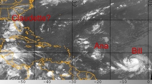
Tropical Storms Ana and Bill formed Saturday.  The National Hurricane Center expects a tropical depression off of the coast of Florida to become Tropical Storm Claudette today.
Tropical Storms Ana and Bill formed Saturday. The National Hurricane Center expects a tropical depression off of the coast of Florida to become Tropical Storm Claudette on Sunday.

Following on the first two named storms of the 2009 Atlantic hurricane season forming Saturday, a third may form off the coast of Florida today. Tropical Storm Ana, the first of the season, formed early Saturday. This was followed by Bill later in the day. Today the National Hurricane Center is forecasting that a tropical depression near Florida will reach tropical storm strength by the end of the day and if so, will be assigned the name Claudette.

Tropical Depression Four is currently 90 miles west-southwest of Tampa, Florida and moving to the north-northwest at 16 mph. With maximum sustained winds of 35 mph, the storm is just below the 39 mph threshold to become a tropical storm.

Strengthening is expected and the NHC predicts the system will become a tropical storm before it hits the coast. In anticipation of this, a tropical storm warning has been issued from the Alabama / Florida border east to the Suwannee River in Florida. Rainfall accumulations from 3 to 5 inches are expected with coastal storm surge of 3 to 5 feet.

For more information:

There's more to this story on the Denver Weather Examiner's site!For complete details on this potential triple threat, read the full story on Examiner.com.

Tropical Storm Ana forms in the Atlantic

Tropical Storm Ana has formed in the Atlantic and become the first named storm in that basin of the 2009 season.

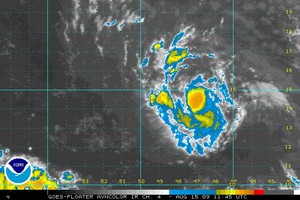
The 2009 hurricane season began on June 1st but it wasn’t until this week that the Atlantic basin finally started to really show signs of life. Tropical Storm Ana has formed over the eastern Atlantic becoming that ocean basin’s first named storm of the 2009 season. By contrast, the Pacific basin has had nine storms with Hurricane Guillermo currently being the latest.

The National Hurricane Center says that Tropical Storm Ana is currently 1,010 miles east of the Leeward Islands where a Tropical Storm Watch may be issued later today. The storm is moving west at 16 mph with maximum sustained winds of 40 mph. The NHC says that Ana is expected to strengthen and pick up speed over the next 48 hours.

For more information:

There's more to this story on the Denver Weather Examiner's site!For more details, view the complete story on Examiner.com.