|
Sarasota, Florida (dpa) – The south-eastern US coast was likely to be spared the wrath of Hurricane Joaquin, but rainfall from a low pressure system drenched several states Saturday. Flood warnings were posted in several coastal states, reaching accumulations of up to 25 centimetres in already saturated areas. One of the worst hit was South Carolina,… Continue reading Weather system deluges eastern US coast as hurricane threat eases |
Tag Archives: flooding
Helmet cam captures motorcycle rider trying to cross Colorado floodwaters

September 2013 went into the history books as one of the most disastrous in Colorado history as torrential rains brought devastating flooding. Most residents heeded warnings meant to save lives but newly discovered video showcases one man ignoring them and nearly drowning in the process.
The video, released by action camera maker GoPro last week, features motorcycle rider Michael Henao attempting to cross flooded Colorado roadways near Boulder. The results were nearly deadly.
Shown from his helmet-mounted camera, Henao starts on on mud-covered roads but then continues on what is clearly a closed road. Water that initially appears calm gets deeper and runs faster as he rides further into the floodwaters.
Read the rest of this story and watch the amazing video on Examiner.com
NOAA satellite image captures ‘biblical’ storm as it strikes Colorado
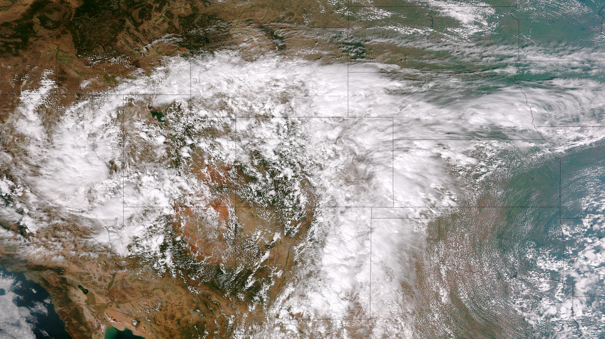
* Click the image above for a larger view
Five days of rain, one with absolutely torrential downpours, created dangerous and deadly flooding across much of the Colorado Front Range. At one point the National Weather Service warned of ‘biblical rainfall amounts’ and it became hard to argue with that terminology. The rainfall amounts were truly astounding.
Boulder, where some of the worst flooding was seen, recorded 9.08” on Thursday, September 12. Estes Park, where the Big Thompson River flooded its banks, saw 3.9” over the 24 hour period.
Officially Denver only saw 1.1” on the date but that was as measured at Denver International Airport which only saw the edge of the storms. At the previous historical location in Stapleton, 3.68” was measured.
Here in Thornton we seemed to be right in line for the storms and generated one of the higher totals in the metro area accumulating 4.76” on the date. Since the rain started five days ago, we have received an amazing 7.66” (as of this writing).
Raw video: Colorado’s flooding in Boulder and Estes Park
What has been called a 100-year storm and even referred to as being of ‘biblical’ proportions is very slowly coming to an end. The worst of the rain fell on Thursday, September 12 with locations in Colorado’s foothills reporting in excess of 8 inches of rainfall.
Among the hardest hit areas were the college town of Boulder and picturesque Estes Park. Both cities have seen extensive flooding and damage totals across the state will be well into the tens, if not hundreds, of millions of dollars.
The two videos below capture the raging waters as they pummeled the communities.
The first video shows Boulder as well as some commentary by Gov. John Hickenlooper. The second is of downtown Estes Park.
United States sees record-setting number of billion dollar disasters in 2011

According to the National Climatic Data Center (NCDC), the U.S. has seen a record number of billion dollar disasters in 2011. Thus far this year the nation has seen 10 such disasters and with hurricane season far from over, it seems likely the number will grow.
The events range from the Groundhog Day Blizzard to Hurricane Irene’s recent devastating blow to the East Coast. In all, the disasters represent more than $35 billion in losses and that is no including Irene’s yet to be determined toll.
Below is the list and narrative for each disaster from the NCDC. For the latest disaster news, be sure to check out the Natural Disasters Examiner.
Hurricane Irene, August 20-29, 2011 While it will take several months to determine an accurate estimate of the damage from Hurricane Irene, there is no question it will rank as the 10th billion-dollar weather event of the year. This 10th U.S. billion-dollar disaster officially breaks the annual record dating back to 1980.
Upper Midwest Flooding, Summer, 2011 Melting of an above-average snow pack across the Northern Rocky Mountains combined with above-average precipitation caused the Missouri and Souris Rivers to swell beyond their banks across the Upper Midwest (MT, ND, SD, NE, IA, KS, MO). An estimated 11,000 people were forced to evacuate Minot, North Dakota due to the record high water level of the Souris River, where 4,000 homes were flooded. Numerous levees were breached along the Missouri River, flooding thousands of acres of farmland. Estimated losses exceed $2.0 billion as the event continues to unfold (as of 8/15). The flooding also stretched into the Canadian Prairies, where property and agriculture losses were expected to surpass $1.0 billion, at least 5 deaths.
Mississippi River flooding, Spring-Summer, 2011 Persistent rainfall (nearly 300 percent normal precipitation amounts in the Ohio Valley) combined with melting snowpack caused historical flooding along the Mississippi River and its tributaries. Estimated economic loss ranges from $2.0-4.0 billion; at least 2 deaths. Below are more detailed stats, which are preliminary, as the event continues to unfold (as of 8/15): $500 million to agriculture in Arkansas; $320 million in damage to Memphis, Tennessee; $800 million to agriculture in Mississippi; $317 million to agriculture and property in Missouri’s Birds Point-New Madrid Spillway; $80 million for the first 30 days of flood fighting efforts in Louisiana.
Southern Plains/Southwest Drought, Heatwave, & Wildfires, Spring-Summer, 2011 Drought, heatwave, and wildfires have created major impacts across the Texas, Oklahoma, New Mexico, Arizona, southern Kansas, and western Arkansas and Louisiana. In Texas and Oklahoma, respectively, 75% and 63% of range and pasture conditions were classified in ‘very poor’ condition as of mid-August. Wildfire fighting/suppression costs for the region are also ~$1 million / day with over 2,000 homes and structures lost. The total direct losses (as of August 15) to agriculture, cattle and structures are well over $5.0 billion; both direct and total economic losses will rise dramatically as the event continues.
Midwest/Southeast Tornadoes, May 22-27, 2011 Outbreak of tornadoes over central and southern states (MO, TX, OK, KS, AR, GA, TN, VA, KY, IN, IL, OH, WI, MN, PA) with an estimated 180 tornadoes and 177 deaths. Notably, an EF-5 tornado struck Joplin, MO resulting in at least 141 deaths, making it the deadliest single tornado to strike the U.S. since modern tornado record keeping began in 1950. Over $4.9 billion insured losses for event; total losses greater than $7.0 billion; 177 deaths.
Southeast/Ohio Valley/Midwest Tornadoes, April 25-30, 2011 Outbreak of tornadoes over central and southern states (AL, AR, LA, MS, GA, TN, VA, KY, IL, MO, OH, TX, OK) with an estimated 305 tornadoes and 327 deaths. Of those fatalities, 240 occurred in Alabama. The deadliest tornado of the outbreak, an EF-5, hit northern Alabama, killing 78 people. Several major metropolitan areas were directly impacted by strong tornadoes including Tuscaloosa, Birmingham, and Huntsville in Alabama and Chattanooga, Tennessee, causing the estimated damage costs to soar. Over $6.6 billion insured losses; total losses greater than $9.0 billion; 327 deaths.
Midwest/Southeast Tornadoes, April 14-16, 2011 Outbreak of tornadoes over central and southern states (OK, TX, AR, MS, AL, GA, NC, SC, VA, PA) with an estimated 160 tornadoes. Despite the large overall number of tornadoes, few were classified as intense, with just 14 EF-3, and no EF-4 or EF-5 tornadoes identified. Over $1.4 billion insured losses; total losses greater than $2.0 billion; 38 deaths [22 of which were in North Carolina].
Southeast/Midwest Tornadoes, April 8-11, 2011 Outbreak of tornadoes over central and southern states (NC, SC, TN, AL, TX, OK, KS, IA, WI) with an estimated 59 tornadoes. Over $1.5 billion insured losses; total losses greater than $2.2 billion; numerous injuries, 0 deaths.
Midwest/Southeast Tornadoes, April 4-5, 2011 Outbreak of tornadoes over central and southern states (KS, MO, IA, IL, WI, KY, GA, TN, NC, SC) with an estimated 46 tornadoes. Over $1.6 billion insured losses; total losses greater than $2.3 billion; 9 deaths.
Groundhog Day Blizzard, Jan 29-Feb 3, 2011 Large winter storm impacting many central, eastern and northeastern states. The city of Chicago was brought to a virtual standstill as between 1 and 2 feet of snow fell over the area. Insured losses greater than $1.1 billion; total losses greater than $2.0 billion; 36 deaths.
Monsoon season arrives early, brings heavy rains to Thornton area
")
La Niña is winding down and normally we would expect a drier than normal monsoon. Mother Nature however has other plans as she not only brought the season to Thornton early, it came with a vengeance this week.
In a presentation that just came out at the first of the month, the National Weather Service discussed the coming monsoon. At that time forecasters predicted a drier and shorter than normal monsoon for the Colorado Front Range. Thus far it has been anything but.
- Be sure to follow us on Twitter and ‘like’ us on Facebook for all the latest weather news!
This past week copious amounts of moisture have streamed into Colorado. Coupled with daytime heating leading to a good deal of atmospheric instability, thunderstorms have been a daily occurrence. Strong winds and heavy rain have occurred virtually daily.
Over the past five days Denver has recorded 1.78 inches of rain at the city’s official monitoring station at Denver International Airport. Closer to where population actually lives even greater amounts have been seen.
Here in Thornton we have recorded 1.98 inches of rain over the past five days. Other amounts over the same period recorded at nearby stations include 1.79 inches in Arvada, 3.18 inches at Reunion in Commerce City, and 3.06 inches in north Denver.
On Friday evening, a slow-moving thunderstorm dumped heavy rain on the southern parts of Thornton. Video footage from storm chaser Tony Laubach (below) shows the end result as streets in the area of I-25 and 84th Avenue were flooded.
Is there an end in sight? Not in the immediate future. For at least the next few days atmospheric moisture will continue to be in abundance and we will continue to see the same general pattern. By mid-week we may see some drying but we can’t entirely eliminate the threat of afternoon thunderstorms.
As always you can get the latest Thornton forecast here.
Death toll in Brazilian flooding and landslides climbs over 800
 via Wikimedia Commons")
Australia and Brazil have both been besieged by heavy rains and flooding in recent weeks. While Australia’s damage was more widespread, the death toll in Brazil has been far more severe.
At latest count at least 809 people have been killed in the flooding in areas just north of Rio de Janeiro. 389 are reported dead from the floods and mudslides in Nova Friburgo and 324 in Teresolis. With at least 200 people missing the toll may eventually exceed 1,000.
More than 20,000 people have been forced out of their homes as flash floods and mud rushed through the Serrana region and the Brazilian government is being heavily criticized for its lax oversight of construction standards. The lack of a proper weather warning system and civil defense plan have also been highlighted by the calamity.
Many within the country and in the international community are questioning the ability of Brazil to play host to the World Cup and the Olympics later this decade. Brazilian daily newspaper Estado de S. Paulo wrote, “A look at public policy … or the lack thereof … reveals a long chain of unpreparedness, administrative incompetence, technical incapacity, and political irresponsibility.”
The recent deaths far surpass Brazil’s previous worst natural disaster. That event, a flood in the state of Sao Paulo in 1967, claimed 436 lives.
For complete coverage of all types of natural disasters, please visit the Natural Disasters Examiner.
Aussie teens learn what type of flotation device not to use in a flooding river
")
Sometimes you just can’t save people from themselves. With Australia battling flooding across four of its states, emergency officials have had their hands full providing relief and rescuing those affected by the disaster. The Natural Disasters Examiner reports about how the decision by a young couple to test the floodwaters with inflatable sex dolls earlier this week was not met with amusement by authorities.
The 19-year-old couple chose to enter the waters of the Yarra River near Melbourne with inflatable sex dolls to aid them in their swim. The rushing waters apparently were too much for the pair – and the dolls – and they soon found themselves in danger.
- Don’t miss – NASA & NOAA satellite imagery of the flooding in Australia (Examiner.com)
The young lady held onto a tree while her companion and his doll stood watch and began yelling for help. A passerby called police and rescue units retrieved the couple from the river.
According to The Telegraph, officials told the couple that sex dolls were “not a recognized flotation device.” Authorities were not pleased to have had to divert resources for a rescue that should not have been necessary.
Flooding in Australia has become a disaster of gargantuan proportions as hundreds of thousands of acres across four states have been flooded. More than 30 people have been killed and tens of thousands of people are now homeless.
California’s ‘big one’ may not be an earthquake
")
California and earthquakes go together like coffee and a cup but a new study suggests that an entirely different kind of disaster may have a bigger impact. The U.S. Geological Survey gathered 117 scientists to evaluate a hypothetical – but possible – “super storm” and its impact on the Golden State.
At the end of 1861 and into the beginning of 1862 a very wet Pacific storm inundated California with rain. This storm turned much of the Sacramento Valley into an inland sea and flooded an area hundreds of miles long.
Today, California is the United State’s most populous state and it has the equivalent of the eighth largest economy in the world. The study shows that if a similar storm were to occur today the result would be disastrous.
The implications of this disaster scenario are tremendous and stretch far beyond California’s borders. Further, one has to wonder ‘what if’ Thornton and the Denver area were presented with a similar scenario?
Read more about the study at the Natural Disasters Examiner.
Australian floods continue unabated flooding hundreds of thousands of square miles

The death toll from the relentless flooding in Queensland, Australia continues to climb as four people were killed in a flash flood. The rising waters have inundated an area covering hundreds of thousands of square miles and now threaten the city of Brisbane.
The most recent fatalities, two adults and two children, occurred near the city of Toowoomba when flash floods swept their vehicle from the road. A wall of water as high as 26 feet (eight meters) raged through the area in the wake of a rainstorm.
Cars, furniture and people were tossed around by the rushing waters and search and rescue operations continue as fears of additional deaths weigh heavily. The waters hit with enough intensity to move houses from their foundations and landslides covered highways.
Premier Anna Bligh told a press conference, “Mother Nature has unleashed something shocking on Toowoomba.”
- Don’t miss – Latest NASA satellite images show expanding floods in Australia (Examiner.com)
Continue reading Australian floods continue unabated flooding hundreds of thousands of square miles